
Howard is a census-designated place (CDP) in southern Howard Township, Knox County, Ohio, United States. As of the 2020 census it had a population of 246. The United States Postal Service has assigned Howard the ZIP Code 43028. The community lies along U.S. Route 36.

East Liberty is an unincorporated community and census-designated place (CDP) located in Perry Township, Logan County, Ohio, United States. As of the 2020 census, it had a population of 371. It is located just off U.S. Route 33, 10 miles (16 km) east of Bellefontaine and 46 miles (74 km) northwest of Columbus. It has a post office with the ZIP code 43319.

Bascom is a census-designated place in western Hopewell Township, Seneca County, Ohio. It has a post office with the ZIP code 44809 and hosts Hopewell-Loudon High School. The community is located at the intersection of State Routes 18 and 635 east of Fostoria. The population was 397 at the 2020 census.
Jacksontown is a census-designated place (CDP) in central Licking Township, Licking County, Ohio, United States. It has a post office with the ZIP code 43030. It lies at the intersection of U.S. Route 40 with State Route 13.

Kunkle is a census-designated place in southeastern Madison Township, Williams County, Ohio, United States. It is located approximately 60 miles (97 km) west of Toledo. The population was 173 at the 2020 census.

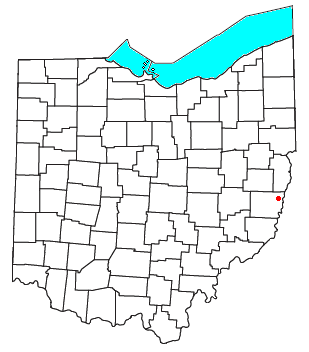
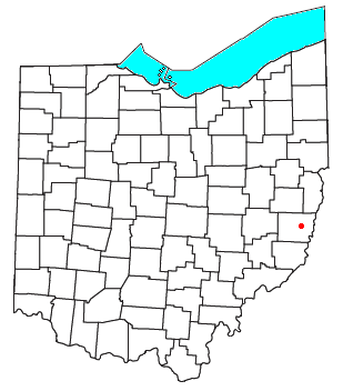
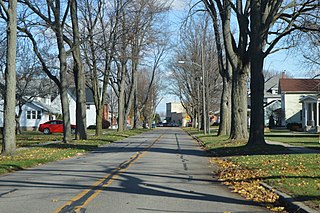
Tippecanoe is an unincorporated community and census-designated place (CDP) in central Washington Township, Harrison County, Ohio, United States. It is located along State Route 800 in the valley of Stillwater Creek, a north-flowing tributary of the Tuscarawas River. It had a post office until 2011 with the ZIP code 44699. The population was 83 at the 2020 census.

Dola is a census-designated place in central Washington Township, Hardin County, Ohio, United States. As of the 2020 United States Census it had a population of 143. It has a post office with the ZIP code 45835.

Radnor is an unincorporated community and census-designated place (CDP) in central Radnor Township, Delaware County, Ohio, United States. As of the 2020 census it had a population of 180. Radnor has a post office with the ZIP code of 43066. It lies along State Route 203 at its intersection with Radnor Road.

Kilbourne is a census-designated place in eastern Brown Township, Delaware County, Ohio, United States. As of the 2020 census it had a population of 127. The community has a post office with the ZIP code of 43032. It lies along State Route 521.

Oceola is a census-designated place (CDP) in central Tod Township, Crawford County, Ohio, United States. As of the 2020 census its population was 156. It has a post office with the ZIP code 44860. It is located along the road that was U.S. Route 30 until being upgraded to a freeway.
Lansing is a census-designated place in northern Pease Township, Belmont County, Ohio, United States, along Wheeling Creek. As of the 2020 census it had a population of 596. It has a post office with the ZIP code 43934.
Glencoe is a census-designated place in southern Richland Township, Belmont County, Ohio, United States. As of the 2020 census it had a population of 264. It has a post office with the ZIP code 43928.
Ridgeville Corners is an unincorporated community and census-designated place (CDP) in southern Ridgeville Township, Henry County, Ohio, United States. It has a post office with the ZIP code 43555. The population was 416 at the 2020 census.

Rockbridge is an unincorporated community and census-designated place (CDP) in eastern Good Hope Township, Hocking County, Ohio, United States. It has a post office with the ZIP code 43149. It is located at the interchange of U.S. Route 33 and State Route 374, between Logan and Lancaster. As of the 2020 census the population of the CDP was 160.

Fresno is a census-designated place in eastern White Eyes Township, Coshocton County, Ohio, United States. As of the 2020 census it had a population of 140. It has a post office with the ZIP code 43824. It lies along State Route 93 between West Lafayette and Baltic.

East Rochester is an unincorporated community and census-designated place (CDP) in southern West Township, Columbiana County, Ohio, United States. The population was 224 as of the 2020 census. It lies along U.S. Route 30, and has a post office with the ZIP code 44625. It is a part of the Salem micropolitan area, about 20 miles (32 km) east of Canton.

New Marshfield is a census-designated place in central Waterloo Township, Athens County, Ohio, United States. The population was 316 at the 2020 census. It has a post office with the ZIP code 45766. It is located along State Route 56 west of the county seat of Athens.

Millfield is a census-designated place in northern Dover Township, Athens County, Ohio, United States. It had a population of 311 at the 2020 census. It has a post office with the ZIP code 45761. It is located near State Route 13 midway between Chauncey and Jacksonville. Route 13 formerly ran through the community, but a bypass relocated it close by.

Reno is a census-designated place in southern Marietta Township, Washington County, Ohio, United States. It has a post office with the ZIP code 45773. It is located on the Ohio River a short distance south of the county seat of Marietta. State Route 7 forms its main street. The population was 1,129 at the 2020 census.
Flat Rock is a census-designated place in northeastern Thompson Township, Seneca County, Ohio, United States. It has a post office with the ZIP code 44828. The population was 227 at the 2020 census.


