
Bledlow is a village in the civil parish of Bledlow-cum-Saunderton in Buckinghamshire, England. It is about 1+1⁄2 miles (2.4 km) WSW of Princes Risborough, and is on the county boundary with Oxfordshire.

Bledlow Ridge is a village in the civil parish of Bledlow-cum-Saunderton in Buckinghamshire, England. In 2004 the population was 940. It is situated in the Chiltern Hills, about 4 miles SSW of Princes Risborough and on the road between the High Wycombe and Chinnor.

Great Marlow is a civil parish within Wycombe district in the English county of Buckinghamshire, lying north of the town of Marlow and south of High Wycombe. The parish includes the hamlets of Bovingdon Green, Burroughs Grove, Chisbridge Cross and Marlow Common. Prior to November 2007 the major settlement in Great Marlow was Marlow Bottom which has now become a civil parish in its own right.

Saunderton is a village in the Saunderton Valley in the Chiltern Hills, Buckinghamshire, England, in the civil parish of Bledlow-cum-Saunderton. The village consists of three main areas: a linear settlement along Bledlow Road about 1+1⁄4 miles (2 km) southwest of Princes Risborough, Saunderton Lee, about 1+1⁄2 miles (2 km) further south and a residential area on the A4010 road around Saunderton railway station, about 4+1⁄2 miles (7 km) northwest of High Wycombe. This residential area, unlike the other two parts of the village, is in the HP14 postcode district, meaning its post town is High Wycombe, not Princes Risborough, the boundary between the two post towns passing just south of Grange Farm.

Aylesbury is a constituency created in 1553 — created as a single-member seat in 1885 — represented in the House of Commons of the United Kingdom since 2019 by Rob Butler of the Conservative Party.
Brogborough is a village and civil parish in the Central Bedfordshire district of Bedfordshire, England, by junction 13 of the M1 motorway. According to the 2001, census it had a population of 343, reducing to 302 at the 2011 Census. The village is about 2.5 miles (4 km) east of Milton Keynes in Buckinghamshire.

Burland is a village and civil parish in the unitary authority of Cheshire East and the ceremonial county of Cheshire, England, about 2½ miles west of Nantwich. The civil parish also includes the small settlements of Burland Lower Green, Burland Upper Green, Hollin Green and Stoneley Green, as well as parts of Gradeley Green and Swanley. The eastern part of the village of Ravensmoor also falls within the civil parish.

Martin is a village and civil parish in the New Forest district in Hampshire. The nearest town Fordingbridge is 7 miles (11 km) to the southeast, and the cathedral city of Salisbury is 12 miles (19 km) to the northeast.
Skittle Green is a hamlet in the civil parish of Bledlow-cum-Saunderton in the county of Buckinghamshire, England.

Wisborough Green is a village and civil parish in the north of the Chichester district of West Sussex, England, 2 miles (3.2 km) west of Billingshurst on the A272 road.

Calveley is a village and civil parish in the unitary authority of Cheshire East and the ceremonial county of Cheshire, England. The village lies 5½ miles to the north west of Nantwich. The parish also includes parts of the settlements of Barrets Green and Wardle Bank. The total population is 280 people. The area is largely agricultural and includes a short stretch of the Shropshire Union Canal. There is an Anglican parish church, a primary school and a public house. Nearby villages include Alpraham, Bunbury, Haughton and Wardle.

Chorley is a hamlet and civil parish in the unitary authority of Cheshire East and the ceremonial county of Cheshire, England. The hamlet lies 5 miles to the west of Nantwich and 6 miles to the north east of Malpas. The total population is a little over a hundred people. Nearby villages include Faddiley, Norbury, Ravensmoor and Wrenbury.
Itchingfield is a small village and civil parish in the Horsham district of West Sussex, England. It lies on the Barns Green to Broadbridge Heath road 2.7 miles (4.3 km) southwest of Horsham.
Shipley is a village and civil parish in the Horsham District of West Sussex, England. It lies just off the A272 road 6 miles north-east of Storrington. The parish includes the village of Coolham and the hamlets of Dragon's Green, Brooks Green and Broomer's Corner.

Carbrooke is a village and civil parish in the Breckland district of mid-Norfolk, East Anglia, England in the United Kingdom. It is 3 miles (4.8 km) from the centre of Watton, 8 miles (13 km) from Dereham and 17 miles (27 km) from its postal town of Thetford. It has an area of 12.66 km2 (4.89 sq mi) with an estimated population of 1,310 in 2007. The measured population at the Census 2011 was 2,076.

Cranworth is a village and civil parish in the Breckland district of mid-Norfolk, East Anglia, England, in the United Kingdom. It has an area of 20.63 km2 (7.97 sq mi) with an estimated population of 415 in 2007, increasing to 419 taken at the 2011 Census.

Hockham is a civil parish in the English county of Norfolk. It covers an area of 13.36 km2 (5.16 sq mi) and had a population of 620 in 252 households at the 2001 census. For the purposes of local government, it falls within the district of Breckland. The district's 2007/08 estimate suggests that the population had risen to 645. At the 2011 Census the population was measured at 603 only in 259 households.

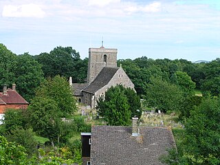
Clothall is a village and civil parish in the county of Hertfordshire, England, with a population of 358. It is situated 2.25 miles (3.62 km) south-east of Baldock, and is in the district of North Hertfordshire. At the 2011 Census the civil parish had a population of 150. The village contains the Church of St Mary the Virgin, which was built of flint and stone around 1350–70, though parts of the church are older, dating to the 12th century.

Great Munden is a village and civil parish in Hertfordshire, England. The parish, in the district of East Hertfordshire, spans 3,758 acres (5.872 sq mi), of which 1,895.75 acres (2.96211 sq mi) are arable land, 927.5 acres (1.4492 sq mi) are permanent grass and 97 acres (0.152 sq mi) are wood. It has a population of 477, reducing to 339 at the 2011 Census, and is situated 6 miles (9.7 km) north of the town of Ware. The village includes the church of St Nicholas, Munden Bury, and a rectory that includes the remains of a moat. Other settlements in the parish include Nasty and Levens Green. A detached portion of Little Munden was added to the parish in 1888.


