
Slovakia is a landlocked Central European country with mountainous regions in the north and flat terrain in the south.

A ski resort is a resort developed for skiing, snowboarding, and other winter sports. In Europe, most ski resorts are towns or villages in or adjacent to a ski area – a mountainous area with pistes and a ski lift system. In North America, it is more common for ski areas to exist well away from towns, so ski resorts usually are destination resorts, often purpose-built and self-contained, where skiing is the main activity.
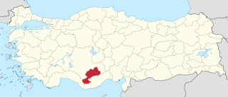
Karaman Province is a province of south-central Turkey. It has an area of 9,163 km2. It has a population of 232,633. According to the 2000 census the population was 243,210. Population density is 27.54 people/km2. The traffic code is 70. The capital is the city of Karaman. Karaman was the location of the Karamanid Beylik, which came to an end in 1486.

Beaumont-Hamel is a commune in the Somme department in Hauts-de-France in northern France.

Nelaug is a lake in the municipalities of Froland and Åmli in Aust-Agder county, Norway. The 10 kilometres (6.2 mi) lake is formed by a dam which regulates a hydroelectric power plant on the Nidelva river. The village of Nelaug is located near the dam in Froland municipality. The lake is located about 11 kilometres (6.8 mi) south of the village of Åmli, about 15 kilometres (9.3 mi) southeast of the village of Dølemo, and about 20 kilometres (12 mi) north of Blakstad.

Hirekudi is a village in the southern state of Karnataka, India. It is located in the Chikodi taluk of Belgaum district in Karnataka.
Inchal is a village in the southern state of Karnataka, India. It is located in the Saundatti taluk of Belgaum district in Karnataka.
Madabhavi is a large village located in Athani taaluk of Belagavi district, Karnataka state of India. The village is famous for production leather chappals which have main market in Kolhapur. The village name came from Madya means central and Bhavi means open well. Open well is near panchayat of village.This village Has two Oldest Ancients Temples one Kalbhairava and another one is Madhukeshwar temple.

Mullur is a village near Sarjapur road in Karnataka, India. It is in Bengaluru East Taluk, Bengaluru District in Karnataka. An adjacent village is Gunjur via Kachamaranahalli. The distance from Vidhana Soudha is 22 km.out of the village there is one school called Sri Sri Ravishankar vidhya mandir and there is a railway station 3.5 km from the village.

The following is a list of reportedly haunted locations in the United Kingdom.
Badachi is a village in Belgaum district in the southern state of Karnataka, India. It is located in Athani Taluka of Belgaum District, near Bijapur -Athani Highway. Maashahibi Darga is situated in the village managed by native Mulla(s) .Allabax S MULLA, Peeralal s mulla, Badashahlal d mulla and every year Maashahibi and Shakarbashah Uras is happen in april or may month,
Basapur is a village in Hukeri taluk, Belgaum district in the southern state of Karnataka, India.
Halashi (Halasi) is a historical village in Belgaum district in the southern state of Karnataka, India. It is about 45 kilometres away from Belgaum on the route to Dandeli, Goa.
Halolli is a village in Belgaum district in the southern state of Karnataka, India.
Kanakumbi is a village in Belgaum district in Karnataka, India. A beautiful village situated on boarder of satteri taluka Goa. Near cities are mapusa 65km. Punaji 71km. Belgaum city 45km. 101%konkani speaking people village. And people use village officially language is marathi. Karnataka and maharashtra boarder disputes on thise village but kanakumbi people not happy to accept or merge in maharashtra. But linguistic diversity kanakumbi village and their neibhar Villages injusticed by central govt. All people village belong hindu 96kuli Maratha community.village situated on MH Goa Ka boarder.
Nallanatti is a village in Belgaum district of Karnataka, India.
Yadurwadi is a village situated at the banks of the Krishna River in Belagavi district in the southern state of Karnataka, India. Sugarcane is a main source of income for the people here. Farmers also grow soybeans in the monsoon season and wheat in the winter season. Yadurwadi is the part of Yadur Gram Panchayat. Neighbouring villages are Chandur, Shahapur, Khotwadi, Hale Yadur, Hosa Yadur and Khidrapur
Yadoga is a village in Uttar kannada district in the state of Karnataka, India.
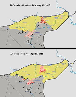
The Eastern al-Hasakah offensive was launched in the Al-Hasakah Governorate during the Syrian Civil War, by the Kurdish People's Protection Units, Assyrian Christian militias, and allied Arab forces against the jihadist Islamic State of Iraq and the Levant, with the intent of retaking the areas of the Jazira Canton that had been captured by ISIL. Subsequently, the Syrian Armed Forces also launched an assault against the radical militants, without coordinating with the Kurds.
The Western Nineveh offensive (2017), code-named Operation Muhammad, Prophet of God, was launched by the Iraqi Popular Mobilization Forces (PMF) against the Islamic State of Iraq and the Levant (ISIL) in the western Nineveh province of northern Iraq in late April 2017.


