The Tejon Pass, previously known as Portezuelo de Cortes, Portezuela de Castac, and Fort Tejon Pass is a mountain pass between the southwest end of the Tehachapi Mountains and northeastern San Emigdio Mountains, linking Southern California north to the Central Valley. Both the pass and the grade north of it to the Central Valley are commonly referred to as "the Grapevine". It has been traversed by major roads such as the El Camino Viejo, the Stockton – Los Angeles Road, the Ridge Route, U.S. Route 99, and now Interstate 5.
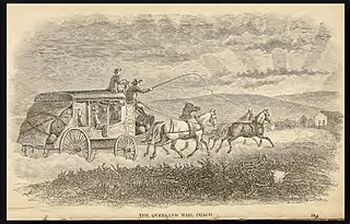
Butterfield Overland Mail was a stagecoach service in the United States operating from 1858 to 1861. It carried passengers and U.S. Mail from two eastern termini, Memphis, Tennessee, and St. Louis, Missouri, to San Francisco, California. The routes from each eastern terminus met at Fort Smith, Arkansas, and then continued through Indian Territory (Oklahoma), Texas, New Mexico, Arizona, Mexico, and California ending in San Francisco. On March 3, 1857, Congress authorized the U.S. postmaster general, at that time Aaron V. Brown, to contract for delivery of the U.S. mail from St. Louis to San Francisco. Prior to this, U.S. Mail bound for the Far West had been delivered by the San Antonio and San Diego Mail Line since June 1857.

Elizabeth Lake is a natural sag pond that lies directly on the San Andreas Fault in the northern Sierra Pelona Mountains, in northwestern Los Angeles County, southern California.

Oak Grove Butterfield Stage Station is located in the western foothills of the Laguna Mountains, in northern San Diego County, California. It is located on State Route 79, 13 miles (21 km) northwest of Warner Springs and Warner's Ranch. The station was built on the site of Camp Wright, an 1860s Civil War outpost.
Sackett's Wells is a former settlement in Imperial County, California. It was located 3 miles (4.8 km) west northwest of Plaster City, in or near Coyote Wash.

Southern Emigrant Trail, also known as the Gila Trail, the Kearny Trail, Southern Trail and the Butterfield Stage Trail, was a major land route for immigration into California from the eastern United States that followed the Santa Fe Trail to New Mexico during the California Gold Rush. Unlike the more northern routes, pioneer wagons could travel year round, mountain passes not being blocked by snows, however it had the disadvantage of summer heat and lack of water in the desert regions through which it passed in New Mexico Territory and the Colorado Desert of California. Subsequently, it was a route of travel and commerce between the eastern United States and California. Many herds of cattle and sheep were driven along this route and it was followed by the San Antonio-San Diego Mail Line in 1857–1858 and then the Butterfield Overland Mail from 1858–1861.
Alamo Mucho Station, the misspelled name of Alamo Mocho Station was one of the original Butterfield Overland Mail stations located south of the Mexican border, in Baja California. Its location is 0.5 miles south-southeast of the Mexicali International Airport Terminal building.
The San Antonio–San Diego Mail Line, also known as the Jackass Mail, was the earliest overland stagecoach and mail operation from the Eastern United States to California in operation between 1857 and 1861. It was created, organized and financed by James E. Birch the head of the California Stage Company. Birch was awarded the first contract for overland service on the "Southern Route", designated Route 8076. This contract required a semi-monthly service in four-horse coaches, scheduled to leave San Antonio and San Diego on the ninth and the 24th of each month, with 30 days allowed for each trip.
In Texas, the Butterfield Overland Mail service created by Congress on March 3, 1857, was operated until March 30, 1861.
The Butterfield Overland Mail was a transport and mail delivery system that employed stagecoaches that travelled on a specific route between St. Louis, Missouri and San Francisco, California and which passed through the New Mexico Territory. It was created by the United States Congress on March 3, 1857, and operated until March 30, 1861. The route that was operated extended from where the ferry across the Colorado River to Fort Yuma Station, California was located, through New Mexico Territory via, Tucson to the Rio Grande and Mesilla, New Mexico then south to Franklin, Texas, midpoint on the route. The New Mexico Territory mail route was divided into two divisions each under a superintendent. Tucson was the headquarters of the 3rd Division of the Butterfield Overland Mail Company. Franklin Station in the town of Franklin,, was the headquarters of the 4th Division.
The Stockton–Los Angeles Road, also known as the Millerton Road, Stockton–Mariposa Road, Stockton–Fort Miller Road or the Stockton–Visalia Road, was established about 1853 following the discovery of gold on the Kern River in Old Tulare County. This route between Stockton and Los Angeles followed by the Stockton–Los Angeles Road is described in "Itinerary XXI. From Fort Yuma to Benicia, California", in The Prairie Traveler: A Hand-book for Overland Expeditions by Randolph Barnes Marcy. The Itinerary was derived from the report of Lieutenant R. S. Williamson on his topographical survey party in 1853, that was in search of a railroad route through the interior of California.
El Camino Viejo a Los Ángeles, also known as El Camino Viejo and the Old Los Angeles Trail, was the oldest north-south trail in the interior of Spanish colonial Las Californias (1769–1822) and Mexican Alta California (1822–1848), present day California. It became a well established inland route, and an alternative to the coastal El Camino Real trail used since the 1770s in the period.
Tejon Creek, originally in Spanish Arroyo de Tejon, is a stream in Kern County, California. Its headwaters are located on the western slopes of the Tehachapi Mountains, and it flows northwest into the southern San Joaquin Valley.
Mud Spring, formerly called Aquaje Lodoso, is a spring and historic site in the western Antelope Valley, within northern Los Angeles County, southern California.
The Butterfield Overland Mail route in Baja California was created as a result of an act by the United States Congress on March 3, 1857, and operated until June 30, 1861 as part of the Second Division of the route. Subsequently other stage lines operated along the route until the Southern Pacific Railroad arrived in Yuma, Arizona.
Willow Springs Station was a changing station at Alamos or Willow Springs along the Second Division route of the Butterfield Overland Mail, in what is now Murrieta, in Riverside County, California. It was also known as Alamos, Clines's or Kline's, or Willows, was one of the later Butterfield Overland Mail stations, placed in 1859, between some of the original stations for changing teams and providing water between stops in hot dry areas. Willow Springs, also originally known as Alamos Springs, was located west of the hills that line the east side of the Temecula Valley, on land of the Rancho Temecula, near Santa Gertrudis Creek on the low flood plain of Murrieta Creek, between Santa Gertrudis and Warm Springs Creek.

Vallecito, in San Diego County, California is an oasis of cienegas and salt grass along Vallecito Creek and a former settlement on the edge of the Colorado Desert in the Vallecito Valley. Its Spanish name is translated as "little valley". Vallecito was located at the apex of the gap in the Carrizo Badlands created by Carrizo Creek and its wash in its lower reach, to which Vallecito Creek is a tributary. The springs of Vallecito, like many in the vicinity, are a product of the faults that run along the base of the Peninsular Ranges to the west.
Palm Spring Station is a former Butterfield Overland Mail stagecoach station located at Palm Spring in San Diego County, California. This station built in 1858 by division agent, Warren F. Hall is commemorated by California State Historical Marker Number 639 Palm Spring.
Carrizo Creek Station, a former stage station of the San Antonio-San Diego Mail Line and Butterfield Overland Mail, located in Imperial County, California just east of the San Diego County line. It lies within the boundaries of the Anza-Borrego Desert State Park just west of the Carrizo Impact Area. Its site is located along the bank of Carrizo Creek.
The Carrizo Creek and Carrizo Wash in California are a stream and an arroyo that the stream flows into, in San Diego County, California and Imperial County, California.