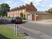
North Thoresby is a village and civil parish in the East Lindsey district of Lincolnshire, England. It is situated between Louth and Grimsby, approximately 7.5 miles (12 km) from each, and has a village population of 1,068 (2011) with 50.5% of the population being over 60.

Skegness is a seaside town and civil parish in the East Lindsey District of Lincolnshire, England. On the Lincolnshire coast of the North Sea, the town is 43 miles (69 km) east of Lincoln and 22 miles (35 km) north-east of Boston. With a population of 19,579 as of 2011, it is the largest settlement in East Lindsey. It also incorporates Winthorpe and Seacroft, and forms a larger built-up area with the resorts of Ingoldmells and Chapel St Leonards to the north. The town is on the A52 and A158 roads, connecting it with Boston and the East Midlands, and Lincoln respectively. Skegness railway station is on the Nottingham to Skegness line.

Horncastle is a town and civil parish in the East Lindsey district in Lincolnshire, 17 miles (27 km) east of Lincoln. Its population was 6,815 at the 2011 census and estimated at 7,123 in 2019. A section of the ancient Roman walls remains.
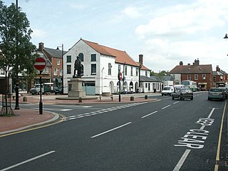
Spilsby is a market town, civil parish and electoral ward in the East Lindsey district of Lincolnshire, England. The town is adjacent to the main A16, 33 miles (53 km) east of the county town of Lincoln, 17 miles (27 km) north-east of Boston and 13 miles (21 km) north-west of Skegness. It lies at the southern edge of the Lincolnshire Wolds and north of the Fenlands, and is surrounded by scenic walking, nature reserves and other places to visit.

The Lincolnshire Wolds are a range of low hills in the county of Lincolnshire, England which run roughly parallel with the North Sea coast, from the Humber Estuary in the north-west to the edge of the Lincolnshire Fens in the south-east. They are a designated Area of Outstanding Natural Beauty (AONB), and the highest area of land in eastern England between Yorkshire and Kent.

Burwell is a small village and Civil parish in the East Lindsey district of Lincolnshire, England. It is situated on the A16 road, and north from Spilsby. The village covers approximately 2200 acres (9 km2).

Donington on Bain is a village and civil parish in the East Lindsey district of Lincolnshire, England.
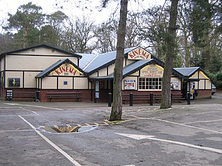
Woodhall Spa is a former spa town and civil parish in Lincolnshire, England, on the southern edge of the Lincolnshire Wolds, 6 miles (10 km) south-west of Horncastle, 23 miles (37 km) west of Skegness, 15 miles (24 km) east-south-east of Lincoln and 17 miles (27 km) north-west of Boston. It is noted for its mineral springs, cinema and its Second World War association with the RAF 617 Squadron. The cinema has the last remaining rear screen projector in the country.
Lincolnshire is one of the few counties within the UK that still uses the eleven-plus to decide who may attend grammar school, in common with Buckinghamshire and Kent.

Huttoft is a village in the East Lindsey district of Lincolnshire, England, about 4 miles (6 km) east of the market town of Alford, on the A52 road between Ingoldmells and Sutton-on-Sea. John Betjeman, later England's Poet Laureate, visited Huttoft in the 1940s and devoted a poem to its parish church.

Firsby is a small rural linear village and civil parish in the East Lindsey district of Lincolnshire, England. It is situated 30 miles (48 km) east from the city and county town of Lincoln, 4 miles (6.4 km) south-east from the nearest market town of Spilsby, and 7 miles (11 km) inland from the holiday resort town of Skegness.

South Thoresby is a village and civil parish in the East Lindsey district of Lincolnshire, England. It is situated 10 miles (16 km) north-east from Horncastle and 8 miles (13 km) south-east from Louth.

Skendleby is a small village and civil parish in the East Lindsey district of Lincolnshire, England. It is situated near to the A158 and lies 35 miles (56 km) east from the county town Lincoln, and about 4 miles (6 km) north-east from the town of Spilsby. The village stands near the south-eastern edge of the Lincolnshire Wolds.

Fulletby is a village and a civil parish in the East Lindsey district of Lincolnshire, England. It is in the Lincolnshire Wolds, and 3 miles (5 km) north-east from Horncastle, 9 miles (14 km) south from Louth, and 8 miles (13 km) north-west from Spilsby. The parish covers approximately 1,950 acres (8 km2). At the time of the 2011 census the population remained less than 100 and is included in the civil parish of Low Toynton.

The Banovallum School is a co-educational secondary school located in Horncastle, Lincolnshire, England.

Raithby by Spilsby or Raithby is a village and civil parish in the East Lindsey district of Lincolnshire, England. It is situated about 2 miles (3.2 km) north-west from the town of Spilsby.

High Toynton is a village and civil parish in the East Lindsey district of Lincolnshire, England. It is situated approximately 1.5 miles (2.4 km) east from the town of Horncastle, and in the Lincolnshire Wolds, a designated Area of Outstanding Natural Beauty.

Tumby is a village in the East Lindsey district of Lincolnshire, England. It is situated approximately 2 miles (3.2 km) north from Coningsby and 6.5 miles (10.5 km) south from Horncastle, and in the civil parish of Kirkby on Bain.

South Willingham is a village and civil parish in the East Lindsey district of Lincolnshire, England, and partly within the Lincolnshire Wolds Area of Outstanding Natural Beauty,. It is situated 1 mile (2 km) south of the A157 Lincoln to Louth road, 15 miles (24 km) west of Lincoln, where the central Lincolnshire Vale and the Lincolnshire Wolds meet. Its population was 160 at the 2011 census, down from a maximum of 341 in 1851.

Middle Rasen is a village and civil parish in the West Lindsey district of Lincolnshire, England, located about 1.5 miles (2.4 km) west from the town of Market Rasen. The population of the civil parish at the 2011 census was 2,043.