Canton (village), New York

Last updated

Canton
Village
Canton NY.JPG
USA New York location map.svg
Red pog.svg
Canton
Location within the state of New York
Coordinates: 44°35′51″N75°10′16″W / 44.59750°N 75.17111°W / 44.59750; -75.17111
CountryUnited States
State New York
County St. Lawrence
Area
[1]
  Total4.27 sq mi (11.07 km2)
  Land4.14 sq mi (10.74 km2)
  Water0.13 sq mi (0.33 km2)
Elevation
377 ft (115 m)
Population
 (2020)
  Total7,155
  Density1,726.18/sq mi (666.49/km2)
Time zone UTC-5 (Eastern (EST))
  Summer (DST) UTC-4 (EDT)
ZIP Code
13617
FIPS code 36-12331
GNIS feature ID0976078
Website http://www.cantonnewyork.us/
United Methodist Church of Canton United Methodist Church of Canton, New York.JPG
United Methodist Church of Canton
The United States Post Office (Canton, New York) is on the National Register of Historic Places US Post Office in Canton, New York.JPG
The United States Post Office (Canton, New York) is on the National Register of Historic Places
First Presbyterian Church of Canton First Presbyterian Church of Canton New York.JPG
First Presbyterian Church of Canton

Canton is a village and county seat of St. Lawrence County, New York, United States. The village is centrally located in both the town of Canton and the county of St. Lawrence. The population was 7,155 at the 2020 census. The name comes from Canton (Welsh: Treganna) in Cardiff, Wales.

Contents

The village of Canton provides many municipal services such as a fully functional village highway department, water and sewer department, volunteer fire department, court system and a police department along with other municipal agencies.

History

The Harrington Hotel in Canton, New York overlooked the Grasse River until it was demolished in 1959. Canton NY - 1923.jpg
The Harrington Hotel in Canton, New York overlooked the Grasse River until it was demolished in 1959.

The first attempt at settlement was made in 1800, but the first permanent settlement occurred in 1801. The first post office used the name "New Cairo," but changed to Canton by 1807. The early economy was based on farming and lumbering.

The village was incorporated in 1845. Between 1887 and 1889, the village was modernized with a sewage system, water works, and electrical lighting.

St. Lawrence University was founded here in 1856, and the State University of New York at Canton (northwest of the village) was begun in 1906.

In addition to Herring-Cole Hall Richardson Hall, and the Old Campus Historic District of St. Lawrence University, the Village Park Historic District and United States Post Office are listed on the National Register of Historic Places. [2]

Notable people

Education

The Village of Canton is home to two colleges. SUNY Canton is a two-/four-year college located in the western part of the village. Its entrance is accessible via NY RT 68 (West Main Street). SUNY Canton is also home to the David Sullivan/St. Lawrence County Law Enforcement Academy that provides police training to local, county, state and federal agencies as well as new police officers in its 5-month police academy every spring.

St. Lawrence University, a four-year liberal arts college located in the eastern part of the village, is home to several sports, including its famous NCAA Division I hockey team and several notable alumni. Access to the college is via US RT 11 (East Main Street).

Canton Central School District is centered in the village of Canton at Hugh Williams Senior High School, home of the Golden Bears.

Police department

The village's police department is located in the municipal building on Main Street. It is composed of a Chief of Police, three sergeants and five patrolmen. The department has one full-time and two part-time dispatchers.

Fire department

The Canton Fire Department, which is at its new location at 77 Riverside Drive, is an all-volunteer fire department with one chief, three assistant chiefs and nearly 80 members. The department also operates a Paramedic Ambulance service and serves the people of the village and town of Canton as well as providing mutual aid services to surrounding towns. In 2008 the fire department answered over 1500 fire and EMS calls.

Geography

Canton is located at 44°35′51″N75°10′16″W / 44.59750°N 75.17111°W / 44.59750; -75.17111 (44.5976, -75.17118). [4]

According to the United States Census Bureau, the village has a total area of 3.3 square miles (8.7 km2), of which 3.2 square miles (8.4 km2) is land and 0.1 square mile (0.3 km2) (2.99%) is water.

The village is located on the Grasse River, a tributary of the St. Lawrence River.

The village is served by U.S. Route 11, New York State Route 68, New York State Route 310, and County Roads 27 and 24.

Demographics

Historical population
CensusPop.Note
1840 800
1850 1,00025.0%
1860 1,56056.0%
1870 1,6817.8%
1880 2,04921.9%
1890 2,58025.9%
1900 2,7576.9%
1910 2,701−2.0%
1920 2,522−6.6%
1930 2,82211.9%
1940 3,0186.9%
1950 4,37945.1%
1960 5,04615.2%
1970 6,39826.8%
1980 7,05510.3%
1990 6,379−9.6%
2000 5,882−7.8%
2010 6,3147.3%
2020 7,15513.3%
U.S. Decennial Census [5] [6]

As of the census [7] of 2000, there were 5,882 people, 1,531 households, and 797 families residing in the village. The population density was 1,817.9 inhabitants per square mile (701.9/km2). There were 1,680 housing units at an average density of 519.2 per square mile (200.5/km2). The racial makeup of the village was 91.81% White, 4.49% Black or African American, 0.54% Native American, 0.99% Asian, 1.02% from other races, and 1.16% from two or more races. Hispanic or Latino of any race were 1.92% of the population.

There were 1,531 households, out of which 26.5% had children under the age of 18 living with them, 38.9% were married couples living together, 10.2% had a female householder with no husband present, and 47.9% were non-families. 38.9% of all households were made up of individuals, and 14.4% had someone living alone who was 65 years of age or older. The average household size was 2.13 and the average family size was 2.86.

In the village, the population was spread out, with 12.3% under the age of 18, 45.8% from 18 to 24, 16.7% from 25 to 44, 13.6% from 45 to 64, and 11.7% who were 65 years of age or older. The median age was 22 years. For every 100 females, there were 101.2 males. For every 100 females age 18 and over, there were 101.2 males.

The median income for a household in the village was $38,627, and the median income for a family was $59,211. Males had a median income of $38,818 versus $28,750 for females. The per capita income for the village was $14,745. About 8.5% of families and 15.6% of the population were below the poverty line, including 19.6% of those under age 18 and 7.1% of those age 65 or over.

Radio

Related Research Articles

<span class="mw-page-title-main">Marion, Kansas</span> City in Marion County, Kansas

Marion is a city in, and the county seat of, Marion County, Kansas, United States. As of the 2020 census, the population of the city was 1,922. The city was named in honor of Francis Marion, a brigadier general of the American Revolutionary War, known as the "Swamp Fox".

<span class="mw-page-title-main">Cambridge Township, Michigan</span> Civil township in Michigan, United States

Cambridge Township is a civil township of Lenawee County in the U.S. state of Michigan. The population was 5,299 at the 2000 census.

<span class="mw-page-title-main">Hillsdale, Missouri</span> Village in Missouri, United States

Hillsdale is a village in St. Louis County, Missouri, United States. Greenwood Cemetery is located in Hillsdale. The population was 1,478 at the 2010 census.

<span class="mw-page-title-main">Velda Village Hills, Missouri</span> City in Missouri, United States

Velda Village Hills is a city in northeastern St. Louis County, Missouri, United States. The population was 1,055 at the 2010 census.

<span class="mw-page-title-main">Clare, New York</span> Town in New York, United States

Clare is a town in St. Lawrence County, New York, United States. The population was 105 at the 2010 census.

<span class="mw-page-title-main">Hopkinton, New York</span> Town in New York, United States

Hopkinton is a town in St. Lawrence County, New York, United States. The population was 1,105 at the 2020 census and has a Population density of 5.9 square miles. The town is named for Roswell Hopkins, a pioneer settler and a government official.

<span class="mw-page-title-main">Madrid, New York</span> Town in New York, United States

Madrid is a town in St. Lawrence County, New York. The population was 1,735 at the time of the 2010 census. The town is named after the capital of Spain. Madrid is in the northern part of the county, north of Canton.

<span class="mw-page-title-main">Piercefield, New York</span> Town in New York, United States

Piercefield is a town in St. Lawrence County, New York, United States. The population was 310 at the 2010 census.

Rensselaer Falls is a village located in St. Lawrence County, New York. As of the 2010 census, the village had a total population of 332. The current name came from mill owner Henry Van Rensselaer.

<span class="mw-page-title-main">Carrollton, Ohio</span> Village in Ohio, United States

Carrollton is a village in and the county seat of Carroll County, Ohio, located 22 miles (35 km) southeast of Canton. The population was 3,087 at the time of the 2020 census. It is part of the Canton–Massillon metropolitan area.

<span class="mw-page-title-main">Chateaugay, New York</span> Town in New York, United States

Chateaugay is a town in Franklin County, New York, United States. As of the 2020 census, the town population was 1,743, down from 2,155 in 2010. The name is derived from a location in France, which was applied to a local land grant.

<span class="mw-page-title-main">Lowville (village), New York</span> Village in New York, United States

Lowville is a village in Lewis County, New York, United States. As of the 2010 census it had a population of 3,470. The village is in the Black River Valley, between the foothills of the Adirondack Mountains and the Tug Hill Plateau, in an area often referred to as the North Country. It is located in the center of Lewis County, in the southeastern part of the similarly named town of Lowville.

<span class="mw-page-title-main">Canton, New York</span> Town in New York, United States

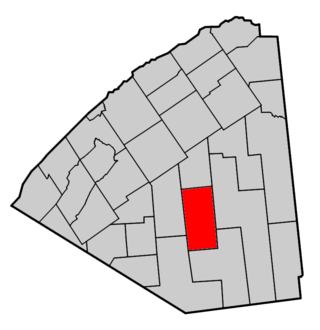
Canton is an incorporated town in St. Lawrence County, New York. The population was 11,638 at the time of the 2020 census. The town contains two villages: one also named Canton, the other named Rensselaer Falls. The town is named after the great port of Canton in China. Canton is the home of St. Lawrence University and the State University of New York at Canton. The Canton Central School District is based in the village of Canton.

<span class="mw-page-title-main">Edwards, New York</span> Town in New York, United States

Edwards is a town in St. Lawrence County, New York, United States. The population was 1,156 at the 2010 census. The village is named after Edward McCormack, brother of the founder.

<span class="mw-page-title-main">Gouverneur, New York</span> Town in New York, United States

Gouverneur is a town in St. Lawrence County, New York, United States. As of the 2020 census, the population was 6,551. That was down from 7,085 in 2010. The town is named after statesman and landowner Gouverneur Morris.

Massena is a village in St. Lawrence County, New York, United States. The village is named after André Masséna, one of Napoleon's generals.

<span class="mw-page-title-main">Potsdam (village), New York</span> Village in New York, United States

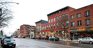
Potsdam is a village located in the Town of Potsdam in St. Lawrence County, New York, United States. The population was 8,312 at the 2020 census. The Village of Potsdam is in the eastern part of the town and is northeast of Canton, the county seat. The village is the locale of the State University of New York at Potsdam and Clarkson University.

Waddington is a village located in the Town of Waddington in St. Lawrence County, New York, United States. The population was 972 at the 2010 census. The village is named after James Waddington.

Waddington is a town in St. Lawrence County, New York, United States. The population was 2,266 at the 2010 census. The town was named after its principal village.

<span class="mw-page-title-main">Jackson (village), Wisconsin</span> Village in Washington County, Wisconsin

Jackson is a village in Washington County, Wisconsin, United States. The population was 7,185 at the 2020 census. The village is adjacent to the Town of Jackson.

References

  1. "ArcGIS REST Services Directory". United States Census Bureau. Retrieved September 20, 2022.
  2. "National Register Information System". National Register of Historic Places . National Park Service. March 13, 2009.
  3. "NRHP listing for Silas Wright Museum" . Retrieved February 15, 2010.
  4. "US Gazetteer files: 2010, 2000, and 1990". United States Census Bureau. February 12, 2011. Retrieved April 23, 2011.
  5. "Census of Population and Housing". Census.gov. Retrieved June 4, 2015.
  6. "United States Census Bureau QuickFacts". United States Census Bureau. Retrieved February 26, 2022.
  7. "U.S. Census website". United States Census Bureau . Retrieved January 31, 2008.