Carpentaria tropical savanna

Last updated

Carpentaria tropical savanna
D Site, Riversleigh, Australian Fossil Mammal Site.jpg
Savanna at Riversleigh fossil site, near Lawn Hill, Queensland.
Ecoregion AA0704.png
Ecoregion territory (in purple)
Ecology
Realm Australasian
Biome tropical and subtropical grasslands, savannas, and shrublands
Borders
Geography
Area365,042 km2 (140,944 sq mi)
Country Australia
States
Coordinates 17°30′S138°57′E / 17.5°S 138.95°E / -17.5; 138.95
Conservation
Conservation status Relatively stable/intact
Protected24,914 km² (7%) [1]

The Carpentaria tropical savanna is a tropical and subtropical grasslands, savannas, and shrublands ecoregion in northern Australia. [2] [3] [4] [5]

Contents

Geography

The ecoregion lies in northwestern Queensland and northeastern Northern Territory, south of the Gulf of Carpentaria. It includes much of Queensland's Gulf Country, and a portion of the Barkly Tableland in the Northern Territory. The ecoregion includes the Wellesley Islands and Pellew Islands in the gulf.

The Roper, Limmen Bight, McArthur, Calvert, Nicholson, Leichhardt, Flinders, Norman, Gilbert, Staaten, and Mitchell rivers drain into the Gulf of Carpentaria. Most have freshwater and brackish wetlands in near the gulf. [2]

It is bounded on the northeast by the Cape York Peninsula tropical savanna, on the east by the Einasleigh Uplands savanna, on the south by the Mitchell Grass Downs, on the west by the Victoria Plains tropical savanna and Kimberley tropical savanna, and on the northwest by the Arnhem Land tropical savanna.

IBRA regions

The ecoregion includes three IBRA regionsGulf Coastal, Gulf Fall and Uplands, and Gulf Plains.

Climate

The ecoregion has a tropical savanna climate. Rainfall is strongly seasonal. The monsoon winds bring rainfall during the Southern Hemisphere summer from November to March, followed by a dry season during the rest of the year. Average annual rainfall generally decreases from north to south. It is highest (1000 mm to 1200 mm) in the northwestern portion of the ecoregion in the Northern Territory, and over 900 mm in the northeastern part of the ecoregion east of the Gulf of Carpentaria. Rainfall is approximately 750 mm along the southern coast of the Gulf of Carpentaria, and decreases to less than 500 mm further south. Temperatures are generally warm year-round, with a wider range between maximum and minimum monthly temperatures as one moves further from the coast. [2] [6]

Flora

The vegetation of the ecoregion includes grasslands, savanna, open woodlands, and small patches of forest.

The Gulf Coastal region, which encompasses the coastal plains along the western Gulf of Carpentaria in Northern Territory, is covered mostly in woodlands of Darwin stringybark (Eucalyptus tetrodonta) with an understory of grasses, chiefly curly spinifex (Triodia pungens). [2]

The Gulf Fall and Uplands, which lies west and south of the gulf coastal plain, is mostly woodland and savanna of Darwin box (Eucalyptus tectifica) and long-fruited bloodwood (Corymbia polycarpa). Curly spinifex is the most common grass, with areas of tall Sorghum grasses, like those typical of Arnhem Land's savannas, in more humid areas of the uplands. [2]

The Gulf Plains, which lie south and southeast of the Gulf, are mostly open grasslands of bluegrass (Dichanthium spp.). In the southwestern Gulf Plains, along the northern edge of the Mount Isa Inlier, there is a narrow belt of Eucalyptus and Melaleuca woodlands, with a grassy understory dominated by Chrysopogon fallax . In the southeastern Gulf Plains close to the Einasleigh Uplands, there are Eucalyptus woodlands, and low woodlands of Melaleuca with the grasses Aristida spp. and Chrysopogon fallax. On the higher plateau remnants in the southeast, there are woodlands of narrow-leaved ironbark (Eucalyptus crebra) and bloodwood (Corymbia spp.), interspersed with stands of lancewood (Acacia shirleyi). [2]

The ecoregion's rivers form freshwater and saltwater wetlands as they approach the gulf. There are extensive mangroves along the coast.

Fauna

The Carpentarian rock rat (Zyzomys palatalis) is endemic to the ecoregion, and found only in patches of ravine forest and vine thickets on sandstone outcrops in Wollogorang Station. The station is located close to the gulf in the Northern Territory near the border with Queensland. [7]

Protected areas

A 2017 assessment found that 24,914 km², or 7%, of the ecoregion is in protected areas. [1] Protected areas in the ecoregion include Limmen National Park, Rutland Plains Nature Refuge, Staaten River National Park, Thuwathu-Bujimulla Indigenous Protected Area, Nijinda Durlga Indigenous Protected Area, Pungalina-Seven Emu Sanctuary, Wongalara Sanctuary, the southern portion of South-East Arnhem Land Indigenous Protected Area, and the northern portion of Boodjamulla National Park. [8]

Related Research Articles

<span class="mw-page-title-main">Top End</span> Region in the Northern Territory, Australia

The Top End of Australia's Northern Territory is a geographical region encompassing the northernmost section of the Northern Territory, which aside from the Cape York Peninsula is the northernmost part of the Australian continent. It covers a rather vaguely defined area of about 245,000 km² behind the northern coast from the Northern Territory capital of Darwin across to Arnhem Land with the Indian Ocean on the west, the Arafura Sea to the north, and the Gulf of Carpentaria to the east, and with the almost waterless semi-arid interior of Australia to the south, beyond the huge Kakadu National Park.

<span class="mw-page-title-main">Llanos</span> Tropical grassland ecoregion in Colombia and Venezuela

The Llanos is a vast tropical grassland plain situated to the east of the Andes in Colombia and Venezuela, in northwestern South America. It is an ecoregion of the tropical and subtropical grasslands, savannas, and shrublands biome.

<span class="mw-page-title-main">Ord Victoria Plain</span> Bioregion in Australia

The Ord Victoria Plain, an interim Australian bioregion, is located in the Northern Territory and Western Australia, comprising 12,540,703 hectares.

<span class="mw-page-title-main">Geography of Western Australia</span>

Western Australia occupies nearly one third of the Australian continent. Due to the size and the isolation of the state, considerable emphasis has been made of these features; it is the second largest administrative territory in the world, after Yakutia in Russia, despite the fact that Australia is only the sixth largest country in the world by area, and no other regional administrative jurisdiction in the world occupies such a high percentage of a continental land mass.

<span class="mw-page-title-main">Geography of the Northern Territory</span> Geography of the Northern Territory region of Australia

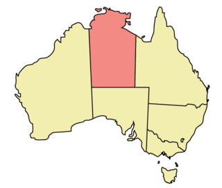
The Northern Territory (NT) occupies the north central part of the continent of Australia. The Northern Territory borders are to the west with Western Australia, the Western Australia border being near the 129° east longitude. The NT to the south with the South Australian border being the 26th parallel south latitude. To the east the NT with the Queensland border along the 138° east longitude.

<span class="mw-page-title-main">Gulf Country</span> Queensland region

The Gulf Country or North West Queensland is the region of woodland and savanna grassland surrounding the Gulf of Carpentaria in north western Queensland and eastern Northern Territory on the north coast of Australia. The region is also called the Gulf Savannah. The Gulf Country is crossed by the Savannah Way highway.

<span class="mw-page-title-main">Arnhem Land tropical savanna</span> Ecoregion in Northern Territory, Australia

The Arnhem Land tropical savanna is a tropical and subtropical grasslands, savannas, and shrublands ecoregion in Australia's Northern Territory.

<span class="mw-page-title-main">Kimberley tropical savanna</span> Terrestrial ecoregion in Western Australia

The Kimberley tropical savanna is a tropical and subtropical grasslands, savannas, and shrublands ecoregion in northwestern Australia, covering portions of Western Australia and the Northern Territory south of the Timor Sea.

<span class="mw-page-title-main">Einasleigh Uplands</span> Bioregion in Queensland, Australia

The Einasleigh Uplands is an interim Australian bioregion, with vegetation consisting of savanna and woodland located on a large plateau in inland Queensland, Australia. It corresponds to the Einasleigh Uplands savanna ecoregion, as identified by the World Wildlife Fund.

<span class="mw-page-title-main">Victoria Plains tropical savanna</span> Ecoregion in Australia

The Victoria Plains tropical savanna is a tropical and subtropical grasslands, savannas, and shrublands ecoregion in northwestern Australia.

<span class="mw-page-title-main">Southeast Australia temperate savanna</span>

The Southeast Australia temperate savanna ecoregion is a large area of grassland dotted with eucalyptus trees running north–south across central New South Wales, Australia.

<span class="mw-page-title-main">Mount Lofty woodlands</span> Ecoregion in South Australia

The Mount Lofty woodlands, or the Peppermint Box Grassy Woodland of South Australia, is an ecoregion in South Australia, which includes woodlands, shrublands, and grasslands in the Mount Lofty Ranges, Fleurieu Peninsula, and Kangaroo Island.

<i>Corymbia confertiflora</i> Species of plant

Corymbia confertiflora, commonly known as broad-leaved carbeen or rough leaf cabbage gum, is a species of tree that is endemic to northern Australia. It has rough, tessellated bark near the base of the trunk, smooth white to pale grey bark above, a crown of both intermediate and adult leaves, large numbers of flower buds borne on leafless sections of branchlets in groups of seven, creamy white flowers and cylindrical to barrel-shaped or bell-shaped fruit.

<i>Corymbia setosa</i> Species of plant

Corymbia setosa, commonly known as rough leaved bloodwood or desert bloodwood, is a species of small tree that is endemic to north-eastern Australia. It has rough, tessellated brown bark on the trunk and branches, a crown of juvenile, heart-shaped leaves arranged in opposite pairs, flower buds in groups of three or seven, white flowers and urn-shaped to shortened spherical fruit.

<span class="mw-page-title-main">Pilbara shrublands</span> Terrestrial ecoregion in Western Australia

The Pilbara shrublands is a deserts and xeric shrublands ecoregion in Western Australia. It is coterminous with the Pilbara IBRA region. For other definitions and uses of "Pilbara region" see Pilbara.

<span class="mw-page-title-main">Cape York Peninsula tropical savanna</span> Region in Queensland, Australia

The Cape York Peninsula tropical savanna is a tropical grasslands, savannas, and shrublands ecoregion in northern Australia. It occupies the Cape York Peninsula in Queensland, mainland Australia's northernmost point. It is coterminous with the Cape York Peninsula, an interim Australian bioregion.

Southern <i>Acacia</i>–<i>Commiphora</i> bushlands and thickets

The Southern AcaciaCommiphora bushlands and thickets is a tropical grasslands, savannas, and shrublands ecoregion in Tanzania and Kenya. It includes portions of Serengeti National Park and Ngorongoro Conservation Area, which are designated World Heritage Sites and biosphere reserves for their outstanding wildlife and landscapes. It is one of three Acacia–Commiphora bushlands and thickets ecoregions in eastern Africa.

<span class="mw-page-title-main">Mitchell Grass Downs</span> Ecoregion in Australia

The Mitchell Grass Downs is a tropical and subtropical grasslands, savannas, and shrublands ecoregion in northeastern Australia. It is a mostly treeless grassland, characterised by Mitchell grasses .

References

  1. 1 2 Eric Dinerstein, David Olson, et al. (2017). An Ecoregion-Based Approach to Protecting Half the Terrestrial Realm, BioScience, Volume 67, Issue 6, June 2017, Pages 534–545; Supplemental material 2 table S1b.
  2. 1 2 3 4 5 6 "Carpentaria tropical savanna". Terrestrial Ecoregions. World Wildlife Fund.
  3. "Map of Ecoregions 2017". Resolve. Retrieved 20 August 2021.
  4. "Carpentaria tropical savanna". Digital Observatory for Protected Areas. Retrieved 20 August 2021.
  5. "Carpentaria tropical savanna". The Encyclopedia of Earth. Retrieved 20 August 2021.
  6. Neldner, Victor & Fox, Ian & Wilson, Garry & Bannink, Peter. (2001). The Vegetation of the Australian Tropical Savannas.
  7. Bowman, D. M. J. S., G. K. Brown, M. F. Braby, J. R. Brown, L. G. Cook, M. D. Crisp, F. Ford, S. Haberle, J. Hughes, Y. Isagi, L. Joseph, J. McBride, G. Nelson and P. Y. Ladiges (2010). "Biogeography of the Australian monsoon tropics". Journal of Biogeography, February 2010. DOI: 10.1111/j.1365-2699.2009.02210.
  8. UNEP-WCMC (2020). Protected Area Profile for Australia from the World Database of Protected Areas, September 2020. Available at: www.protectedplanet.net