Caswell Beach, North Carolina

Last updated

Caswell Beach, North Carolina
Oak Island Light North Carolina.jpg
Caswell Beach–Oak Island Lighthouse
Motto: 
The Best Little Beach Town in America
USA North Carolina location map.svg
Red pog.svg
Caswell Beach
Location within the state of North Carolina
Coordinates: 33°54′27″N78°02′50″W / 33.90750°N 78.04722°W / 33.90750; -78.04722
Country United States
State North Carolina
County Brunswick
Area
[1]
  Total4.10 sq mi (10.62 km2)
  Land2.97 sq mi (7.69 km2)
  Water1.13 sq mi (2.93 km2)
Elevation
[2]
0 ft (0 m)
Population
 (2020)
  Total395
  Density133.04/sq mi (51.37/km2)
Time zone UTC-5 (Eastern (EST))
  Summer (DST) UTC-4 (EDT)
ZIP code
28465
Area codes 910, 472
FIPS code 37-10960 [3]
GNIS feature ID2406237 [2]
Website www.caswellbeach.org

Caswell Beach is a small seaside town located on the Atlantic Ocean at the mouth of the Cape Fear River in Southeastern North Carolina, United States. Occupying the eastern part of Oak Island in Brunswick County, its population was listed at 395 in the 2020 census. Prominent features include the Civil War era Fort Caswell, the Oak Island Lighthouse co-located with the Oak Island Coast Guard Station, and the Oak Island Golf Club, the sole business in town and one of the few eighteen-hole courses located on a North Carolina barrier island. Along with the Town of Oak Island which occupies the central and west parts of the island, Caswell Beach is part of the Wilmington, NC Metropolitan Statistical Area.

Contents

History

Contiguous to Fort Caswell which dates from 1825, Caswell Beach was incorporated as a town in 1975; both were named for Richard Caswell, 1st & 5th Governor of North Carolina. [4] The fort which is located on the extreme eastern end of Oak Island now houses the North Carolina Baptist Assembly, a Christian retreat and conference center and in 2013 it was designated a National Historic District. [5] Also on the east end of town, the Oak Island Lighthouse which became operational in 1958 [6] was acquired by the town in 2004 after extensive negotiations with the National Park Service. [7] In 1975, the same year the town was incorporated, all 18 holes of the Oak Island Golf Club on the west end of town were first opened for play.

Beach Erosion-1998 Caswell Beach-1998.jpg
Beach Erosion–1998
Beachfront property after 1998 Nor'easter Honey Paw (1998).jpg
Beachfront property after 1998 Nor'easter

Caswell Beach slowly developed into a vacation resort community, [8] but was plagued over the years by the incessant erosion of beach sand due to hurricanes and nor-easters. This erosion threatened the town's main thoroughfare (Caswell Beach Rd) and made uninhabitable many ocean front houses. Installation of roadside sandbags provided temporary relief and its success prompted the town to set in motion an intensive restoration and preservation effort focused on installing sand fences and planting sea oats/beach grass. This work was abetted by the Wilmington Harbor Channel Project, which dumped huge amounts of sand on the beach as a least cost disposal option. [9] This effort was very successful and widely recognized as the town received a national award in 2002 for Best Restored Beach. [10]

Geography

Caswell Beach NC Map Caswell Beach NC Map.jpg
Caswell Beach NC Map

Roughly halfway distant from Wilmington, North Carolina and Myrtle Beach, South Carolina, Caswell Beach is located on the east end of Oak Island. This island is the easternmost of the South Brunswick Islands which were formed in the late 1930s by the construction of the Intracoastal Waterway (ICW) which was dredged from Southport, NC at the mouth of the Cape Fear River through coastal sounds and marshes to the Little River in South Carolina. Elevations in the town range from sea level to approximately 25'while the town has a total area of 4.1 square miles (10.5 km2), of which 2.9 square miles (7.6 km2) is land.

Climate

Caswell Beach NC-Average Temperature Range Caswell Beach NC-Average Temperature Range.jpg
Caswell Beach NC-Average Temperature Range

Summers in Caswell Beach are hot and humid with an average temperature of 85˚, although the beach front is cooled much of the time by sea breezes (the prevailing winds are from the southwest). Winters are moderate with an average temperature in the 50s (°F), albeit with brief cold periods. Rain occurs throughout the year with average annual rainfall approximately 57", 45% of this falling between June and September. [11]

Tropical storms are a continuing source of concern, [12] e.g., in October 1954, Hurricane Hazel washed away almost all the houses on Oak Island. A threat in late summer/early fall, the 1996-1999 period was intense with four major hurricanes (Bertha, Fran, Bonnie, and Floyd) making landfall and having significant effects on the area, while in the fall of 2005, Hurricane Ophelia and Tropical Storm Tammy combined to cause flooding in low-lying areas. [13] More recently, in October 2016, the eye of Hurricane Matthew passed almost directly over the town, inflicting extensive damage to the dune system, and in September 2018, Hurricane Florence caused severe flooding and wind damage in addition to washing away most of the beach sand added earlier in the year. [14]

Demographics

Historical population
CensusPop.Note
1980 110
1990 17559.1%
2000 370111.4%
2010 3987.6%
2020 395−0.8%

The 395 people identified in the 2020 census reside in some 190 permanent households (overall there were 681 housing units in Caswell Beach at the time of the census). This population is essentially all white, fairly elderly (median age 63) with more women (55%) than men (45%). Median household income is $74,219. None of the population or families were below the poverty line. While the number of full-time residents is fairly small, in the summer peak population reaches 2,000, mostly family vacationers using rental properties. [15]

Housing

Large single family homes, many of which serve as vacation rental properties, can be found along the beach strand at the east end of town, while on the west end, the ocean-front Oak Island Beach Villas feature condo rental units. Most of the full-time residents live clustered in and around the golf course in various types of housing: the Arboretum (single family homes) [16] Caswell Dunes (patio homes and condo units), [17] and Ocean Greens (single family, duplexes, townhouses, and luxury condos).

Government

The town government operates under a council-manager type system where various officials have authority to make decisions on services, revenues and expenditures in accordance with a state issued charter. The Governing Body consists of six members (the Mayor who votes only in case of a tie and five Commissioners) all of whom are elected for four year terms on a two-year rotational schedule. Town Hall is located in the west end of town next to the newly constructed Public Services Facility, which houses the Caswell Beach Police and Public Works Departments along with units of the Southport Fire Department and Brunswick County EMS. [18]

Attractions

Beach. In way of combating erosion rates ranging from 2-5' per year, the town's three mile long, south facing beach has been re-nourished three times in the past 17 years as part of the Wilmington Harbor Channel dredging project. [19] The beach also serves as a sea turtle nesting area, [20] which has spurred a vigorous dune protection and restoration program featuring sea oats/beach grass plantings. [21] This program not only benefits turtle nesting but protects the town against hurricane storm surge damage. As for public access to the beach, the town maintains a free parking lot and 12 walkways spread out along the strand, most of which have wheelchair ramps.

Caswell Beach-2011 View looking East.jpg
Panoramic view of Caswell Beach in 2011 looking east with the Oak Island Lighthouse in the background
View looking north at the OIGC 18th green Oak Island Golf Club-18th Hole.png
View looking north at the OIGC 18th green
View from the Oak Island Lighthouse looking west Oak Island Lighthouse View.jpg
View from the Oak Island Lighthouse looking west
Fort Caswell (Batteries McKavett and McDonough) Fort Caswell-Battery McKavett & McDonough.jpg
Fort Caswell (Batteries McKavett and McDonough)
Caswell Dunes Rifle Pits Caswell Dunes WWI Rifle Range Painting.jpg
Caswell Dunes Rifle Pits
Intrepid alligator enjoying the surf Caswell Beach Wildlife.jpg
Intrepid alligator enjoying the surf

Golf Course. The 18 hole, par 72 course at the Oak Island Golf Club is open to the public. The 6,720 yard course layout has 37 bunkers and water in play on 11 different holes with five sets of tees (back tees are course rated at 73.1 with a slope of 139). The course features ultradwarf TifEagle greens [22] and Bermuda tees/fairways/rough while Long Leaf Pines, Live Oaks and Yaupon Holly trees border most every fairway. George Cobb, co-designer of Augusta National's par 3 course, is the architect. A full practice facility is available to the public which includes a putting green, sand traps and a driving range. [23]

Lighthouse. The Oak Island Lighthouse grounds are open to the public year-round for viewing and picture taking, with limited 30 minute parking provided at the base of the tower from sunrise until sunset. [24] During the summer months, two types of interior tours are available (the one to the top is by appointment only). The light is maintained by personnel housed at the adjacent Coast Guard Station, while the structure itself is cared for and managed by a citizens group, Friends of Oak Island Lighthouse (FOIL). A major exterior rehabilitation project was completed in 2016, notable in that it was funded entirely by contributions. [25] Located across the street slightly to the east of the lighthouse is the historic Oak Island Life Saving Station.

Fort Caswell Fort Caswell is accessible by the public to a limited extent per the conditions set forth by the Director, North Carolina Baptist Assembly. [26] Now utilized as a Christian retreat and conference center, during the Civil War it defended Confederate positions on the North Carolina coast. Subsequently, it served as an army training ground in World War I and as a patrol communications base in World War II. Thus its forts and batteries provide opportunities to view and connect with a significant part of US history. [27] Also a part of the Fort Caswell Historic District but located further west in the Caswell Dunes area is the Fort Caswell Rifle Range used by WW I soldiers for target practice. [28] Brunswick County in the Great War [29] published in 2020 contains a 25-page section with numerous rifle pit photos and diagrams along with biographic sketches of all known Brunswick County NC WW I service members.

Natural Habitat. Given its small population and remote location, much of the town's charm rests with its salt and fresh water marshes and a maritime forest, all of which support a wide range of plant and animal life. Alligators, turtles, foxes, deer, raccoons, beavers, eagles, brown pelicans, great white and blue herons, and ibis abound, while an occasional bear has been known to swim across the Intracoastal Waterway to visit the town. As for plant diversity, live oak, Longleaf Pine and Yaupon Holly predominate in the forest, while Azaleas, American Beautyberry and Sweet Bay Magnolia thrive both in natural and landscaped areas. [30]

Neighboring Communities

Oak Island. The Town of Oak Island, which occupies the rest of the island, has a contract post office, a branch of the county library, supermarkets, liquor store, two fishing piers [31] a few gas stations, numerous small professional offices/retail stores, and a large number of restaurants. [32]

Southport. Located just across the ICW is the city of Southport (pop. 3,700). Founded as Smithville in 1792, it is home to the NC Fourth of July Festival and has been the location for many movies, one of the more notable being Safe Haven (2013). The part of town known as "Old Southport" has many historic houses and buildings, e.g. Fort Johnston, and situated on its waterfront is the North Carolina Maritime Museum at Southport and year-round ferry service that provides scenic trips across the Cape Fear River [33] to the NC Aquarium and Civil War battleground site at Fort Fisher. [34]

Related Research Articles

<span class="mw-page-title-main">New Hanover County, North Carolina</span> County in North Carolina, United States

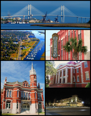
New Hanover County is a county located in the U.S. state of North Carolina. As of the 2020 census, the population was 225,702. Though the second-smallest county in North Carolina by land area, it is one of the most populous, as its county seat, Wilmington, is one of the state's largest communities. The county was created in 1729 as New Hanover Precinct and gained county status in 1739. New Hanover County is included in the Wilmington, NC Metropolitan Statistical Area, which also includes neighboring Pender and Brunswick counties.

<span class="mw-page-title-main">Brunswick County, North Carolina</span> County in North Carolina, United States

Brunswick County is a county located in the U.S. state of North Carolina. It is the southernmost county in the state. As of the 2020 census, the population was 136,693. Its population was only 73,143 in 2000, making it one of the fastest-growing counties in the state. With a nominal growth rate of approximately 47% in ten years, much of the growth is centered in the eastern section of the county in the suburbs of Wilmington such as Leland, Belville and Southport. The county seat is Bolivia, which at a population of around 150 people is among the least populous county seats in the state.

<span class="mw-page-title-main">Bald Head Island, North Carolina</span> Village in North Carolina, United States

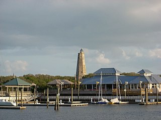
Bald Head Island, historically Smith Island, is a village located on the east side of the Cape Fear River in Brunswick County, North Carolina, United States. Compared to the nearby city of Wilmington to the north, the village of Bald Head Island is small and somewhat remote. It is accessible by ferry from the nearby town of Southport and by four-wheel drive vehicle along the beach strand from Fort Fisher to the north. Only government officials are allowed to drive the beach strand route. There are few cars on the island; instead, residents drive modified electric golf carts. Bald Head Island is nationally recognized for its sea turtle nesting activity.

<span class="mw-page-title-main">Boiling Spring Lakes, North Carolina</span> City in North Carolina, United States

Boiling Spring Lakes is a city in Brunswick County, North Carolina, United States. The population was 5,943 at the 2020 census, up from 5,372 in 2010.

<span class="mw-page-title-main">Oak Island, North Carolina</span> Town in North Carolina, United States

Oak Island is a seaside town located in the southeastern corner of North Carolina, United States. Part of Brunswick County, the major portion of the town is on Oak Island which it shares with Caswell Beach. Founded in 1999 as the result of the consolidation of two existing towns, Oak Island's main industry is tourism. Per the 2020 census, the town has a permanent population of 8,396 while its summer population is near 50,000. It along with the town of Caswell Beach is part of the Wilmington, NC, Metropolitan Statistical Area.

<span class="mw-page-title-main">Southport, North Carolina</span> City in North Carolina, United States

Southport is a city in Brunswick County, North Carolina, United States, near the mouth of the Cape Fear River. Its population was 3,828 as of the 2018 census. The current mayor, Rich Alt, was elected to a two-year term in November 2023.

<span class="mw-page-title-main">Carolina Beach, North Carolina</span> Town in North Carolina, United States

Carolina Beach is a beach town in New Hanover County, North Carolina, United States, situated about 12 miles (19 km) south of Wilmington International Airport in southeastern coastal North Carolina. As of the 2020 census, the city population was 6,564. It is part of the Wilmington metropolitan area. The community of Wilmington Beach was annexed by the town in 2000.

<span class="mw-page-title-main">Oak Island (North Carolina)</span>

Oak Island is located on the Atlantic Ocean coast in Brunswick County, North Carolina near the South Carolina border. A barrier island, it contains the towns of Oak Island and Caswell Beach, Fort Caswell and the Oak Island Coast Guard Station which is co-located with the Oak Island Lighthouse. Almost 13 miles long, the island averages about one mile wide. Approximately 7000 people live on it year-round, a number which can balloon to over 40,000 during the summer

<span class="mw-page-title-main">North Carolina Baptist Assembly</span>

The North Carolina Baptist Assembly is a Christian retreat owned and operated by the Baptist State Convention of North Carolina, the state's largest denomination. The grounds of the retreat, located adjacent to Caswell Beach on the eastern end of Oak Island, is the former site of Fort Caswell, a military base that was occupied by various branches of the U.S. armed forces for most of the period between 1836 and 1945. Most people still refer to the Baptist Assembly as Fort Caswell.

<span class="mw-page-title-main">Oak Island Light</span> Lighthouse in North Carolina, US

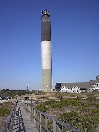
The Oak Island Lighthouse is located in the Town of Caswell Beach near the mouth of the Cape Fear River in Southeastern North Carolina. It sits next to the Oak Island Coast Guard Station on the east end of Oak Island in Brunswick County looking south out at the Atlantic Ocean. Featuring 16 LED lights which produce four, one-second bursts of light every 10 seconds, it has a luminous range of 20.5 nautical miles. Owned by the town since 2004, it is managed by a citizens group.

<span class="mw-page-title-main">Golden Isles of Georgia</span> Place in Georgia, United States

The Golden Isles of Georgia consist of barrier islands, and the mainland port cities of Brunswick and Darien, on the 100-mile-long coast of the U.S. state of Georgia on the Atlantic Ocean. They include St. Simons Island, Sea Island, Jekyll Island, Little St. Simons Island, Sapelo Island, Blackbeard Island, Historic Darien and Historic Brunswick. The islands are part of a long chain of barrier islands known as the "Sea Islands", located along the coasts of South Carolina, Georgia and northern Florida.

<span class="mw-page-title-main">Supply, North Carolina</span> Unincorporated community in North Carolina, United States

Supply is a small unincorporated community in Brunswick County, North Carolina, United States, located around the intersection of US 17 and NC 211. Its name is derived from the use of the Lockwoods Folly River as a trade route in the 18th and 19th centuries. Residents of the nearby beach communities of Holden Beach, Oak Island, Ocean Isle, Caswell Beach, and Sunset Beach often formerly commuted to Supply for goods and other materials. This practice is still common, but development in the town of Southport and in the Intracoastal Waterway commercial districts has made traveling to Supply unnecessary.

<span class="mw-page-title-main">Cape Fear (region)</span> Wilmington metropolitan area

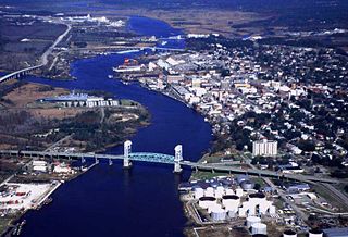
Cape Fear is a coastal plain and Tidewater region of North Carolina centered about the city of Wilmington. The region takes its name from the adjacent Cape Fear headland, as does the Cape Fear River which flows through the region and empties into the Atlantic Ocean near the cape. Much of the region's populated areas are found along the Atlantic beaches and the Atlantic Intracoastal Waterway, while the rural areas are dominated by farms and swampland like that of the Green Swamp. The general area can be also identified by the titles "Lower Cape Fear", "Wilmington, NC Metropolitan Statistical Area", "Southeastern North Carolina", and "Azalea Coast". The latter name is derived from the North Carolina Azalea Festival held annually in Wilmington. Municipalities in the area belong to the Cape Fear Council of Governments.

<span class="mw-page-title-main">Pleasure Island (North Carolina)</span> Coastal barrier island in North Carolina

Pleasure Island is a coastal barrier island in Southeastern North Carolina, United States, just south of the City of Wilmington. Pleasure Island is located within Federal Point Township, in New Hanover County. The coastal resort towns of Carolina Beach and Kure Beach, as well as the annexed communities of Wilmington Beach and Hanby Beach are located on the island. The southern end of Pleasure Island was separated from Bald Head Island by Corncake Inlet until the inlet was shoaled and closed in 1998 by Hurricane Bonnie; thus Pleasure Island and Bald Head Island are no longer separate islands.

Smithville Township is one of six townships within Brunswick County, North Carolina, United States. As of the 2000 Census, Smithville Township had a population of 12,019 and a population density of 152 inhabitants per square mile (59/km2). It is a part of the Wilmington, NC Metropolitan Statistical Area.

<span class="mw-page-title-main">North Carolina Highway 133</span> State highway in North Carolina, US

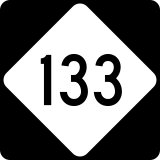
North Carolina Highway 133 (NC 133) is a primary state highway in the U.S. state of North Carolina. It traverses 46.6 miles (75.0 km) from Oak Island Drive in Oak Island to NC 210 in Bells Crossroads. The route serves communities such as Southport, Belville, Leland, Wilmington, and Castle Hayne. Additionally, NC 133 serves as an entry point for Military Ocean Terminal Sunny Point located to its east. Much of NC 133 runs parallel to the Cape Fear River and Brunswick River between Southport and Belville. West of Wilmington, NC 133 runs concurrently with U.S. Route 17 (US 17), US 74, and US 76. The road follows another concurrency along US 74 and US 421, west of Downtown Wilmington, and crosses into New Hanover County on the Isabel Holmes Bridge. North of Wilmington, NC 133 exits to the north, serving several suburban communities north of Wilmington. NC 133 runs concurrently with US 117 through Castle Hayne, before bearing northwest toward Bells Crossroads.

<span class="mw-page-title-main">Fort Caswell Historic District</span> Historic district in North Carolina, United States

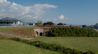
Located in North Carolina on the Atlantic Coast, the Fort Caswell Historic District encompasses 2 sites, 43 buildings, and 23 structures; it was added to the National Register of Historic Places in 2013. The fort itself was occupied by various branches of the U.S. armed forces for most of the period between 1836 and 1945 and is now a part of the North Carolina Baptist Assembly, a Christian retreat, owned and operated by the Baptist State Convention of North Carolina. It is accessible by the public to a limited extent per the conditions set forth by the Assembly’s Director.

<span class="mw-page-title-main">Oak Island Golf Club</span>

The Oak Island Golf Club (OIGC) is located in Caswell Beach NC on the south side of Oak Island looking out at the Atlantic Ocean. Part of the Lower Cape Fear region in Brunswick County, Southeast North Carolina, it is one of the few 18 holes golf courses built on a barrier island. The privately owned 6,720 yard, par 72 course is open to the public and has 37 bunkers with water in play on 11 holes. Laid out with five sets of tees which present a wide range of playability, the back (blue) tees are course rated at 73.1 with a slope of 139. A pro shop/pub/snack bar along with a full practice facility to include a sand trap, both putting and pitching greens, and a driving range is also available to the public.

<span class="mw-page-title-main">Fort Caswell Rifle Range</span> United States historic place

The Fort Caswell Rifle Range located in Caswell Beach NC, is a discontiguous part of Fort Caswell which defended Confederate positions on the North Carolina coast during the Civil War and served both as an army training ground in World War I and a patrol/ communications base in World War II. In 2013, the rifle range which was constructed during WWI, along with Fort Caswell itself, was designated as a National Register of Historic Places property.

<span class="mw-page-title-main">Coast Guard Station Oak Island</span> US Coast Guard station in North Carolina

Coast Guard Station Oak Island referred to locally as the Oak Island Coast Guard Station (OICGS) is located in the Town of Caswell Beach on Oak Island in Brunswick County, North Carolina. A part of the Cape Fear region, the station is in the United States Coast Guard 5th District which is charged with ensuring the safety and security of the oceans, coastal areas, and marine transportation system within the Mid-Atlantic Region. The district encompasses some 156,000 square miles of ocean, bays, rivers, wetlands and tidal marshes, geographic waterways, several major mid-Atlantic ports, and the Nation's capital. They also patrol the mouth of the Cape Fear River in Southport, North Carolina and the Intracoastal Waterway (ICW)

References

  1. "ArcGIS REST Services Directory". United States Census Bureau. Retrieved September 20, 2022.
  2. 1 2 U.S. Geological Survey Geographic Names Information System: Caswell Beach, North Carolina
  3. "U.S. Census website". United States Census Bureau . Retrieved May 22, 2016.
  4. "Governor Caswell". StarNews.com. Retrieved January 30, 2019.
  5. "National Register of Historic Places Listings". Weekly List of Actions Taken on Properties: 12/30/13 through 1/03/14. National Park Service. January 10, 2014.
  6. "National Register of Historic Places" (PDF). NPS.gov. Retrieved May 13, 2019.
  7. "Lighthouse Transfer". LighthouseDigest.com. Retrieved January 25, 2019.
  8. "Census 2010". Census.gov. Archived from the original on February 12, 2020. Retrieved January 30, 2019.
  9. "Harbor Channel Project" (PDF). USACE.gov. Retrieved January 30, 2019.
  10. Bausch F. A. (2013). Nothing Like Losing. Caswell Beach , NC: Amazon. ISBN   978-0-9853517-6-2.
  11. "Climate Data". ClimateData.com. Retrieved January 30, 2019.
  12. "Hurricane Summary" (PDF). NOAA.com. Retrieved January 30, 2019.
  13. Barnes, Jay (2013). North Carolina's Hurricane History: Fourth Edition. UNC Press Books. ISBN   978-1-4696-0652-1.
  14. "Hurricane Florence". Weather.gov. Retrieved January 30, 2019.
  15. "Demographic Profile". Census.gov. Retrieved January 30, 2019.
  16. "Arboretum". Arboretum.com. Retrieved January 30, 2019.
  17. "Caswell Dunes". Caswell Dunes.com. Retrieved January 30, 2019.
  18. "Brunswick County". Brunsco.com. Retrieved January 30, 2019.
  19. "Harbor Dredging Project". StatePortPilot.com. Retrieved January 30, 2019.
  20. "SeaTurtleWatch". SeaTurtle.org. Retrieved January 30, 2019.
  21. Rogers, Spencer; Nash, David (2003). The Dune Book. North Carolina Sea Grant. ISBN   978-0-9747801-1-5
  22. "UltraDwarf Bermuda" (PDF). MSU.edu. Retrieved January 30, 2019.
  23. "Oak Island Golf Club". OakIslandGolf.com. Retrieved January 30, 2019.
  24. "NRHP Listing". NPS.com. Retrieved January 30, 2019.
  25. "Oak Island Lighthouse". OILight.org. Retrieved January 30, 2019.
  26. "Fort Caswell". FortCaswell.com. Retrieved January 30, 2019.
  27. Herring, Ethel; Williams, Carolee (1999). Fort Caswell in War and Peace. Oak Island, NC: NC Baptist Assembly. ISBN   978-0-9671897-1-0.
  28. "Rifle Range". RifleRange.com. Retrieved January 30, 2019.
  29. Eckard, Amy; Eckard, Norma; Eckard, Ron (2020). Brunswick County in the Great War. Oak Island, NC: SlapDash, Wilmington NC. ISBN   978-099-841-15-6-9.
  30. "Coastal Planting Guide" (PDF). FWS.gov. Retrieved January 30, 2019.
  31. "Oak Island Pier". OakIsandPier.com. Retrieved January 30, 2019.
  32. "Town of Oak Island". OakIsland.com. Retrieved January 30, 2019.
  33. "Ferry System Schedule" (PDF). North Carolina. Retrieved March 10, 2023.
  34. "Southport". Southport.com. Retrieved January 30, 2019.

Commons-logo.svg Media related to Caswell Beach, North Carolina at Wikimedia Commons

Preceded by Beaches of Southeastern North Carolina Succeeded by