Cataract, Wisconsin | |
|---|---|
 | |
 Cataract, Wisconsin | |
| Coordinates: 44°05′16″N90°50′32″W / 44.08778°N 90.84222°W | |
| Country | United States |
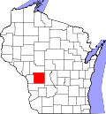
| State | Wisconsin |
| County | Monroe |
| Area | |
• Total | 0.594 sq mi (1.54 km2) |
| • Land | 0.594 sq mi (1.54 km2) |
| • Water | 0 sq mi (0 km2) |
| Elevation | 850 ft (260 m) |
| Population | |
• Total | 220 |
| • Density | 370/sq mi (140/km2) |
| Time zone | UTC-6 (Central (CST)) |
| • Summer (DST) | UTC-5 (CDT) |
| Area code | 608 |
| GNIS feature ID | 1562802 [2] |
Cataract is a census-designated place (CDP) in the Town of Little Falls in Monroe County, Wisconsin, United States. As of the 2020 census, its population was 220, up from 186 at the 2010 census. [3]