Wilton, Wisconsin

Last updated
Wilton, Wisconsin
Wilton, WI welcome sign.JPG
Wilton welcome sign
Monroe County Wisconsin Incorporated and Unincorporated areas Wilton Highlighted.svg
Location of Wilton in Monroe County, Wisconsin.
Coordinates: 43°51′13″N90°29′22″W / 43.85361°N 90.48944°W / 43.85361; -90.48944 Coordinates: 43°51′13″N90°29′22″W / 43.85361°N 90.48944°W / 43.85361; -90.48944
Country Flag of the United States.svg  United States
State Flag of Wisconsin.svg  Wisconsin
County Monroe
Area
[1]
  Total0.89 sq mi (2.31 km2)
  Land0.89 sq mi (2.31 km2)
  Water0.00 sq mi (0.00 km2)
Elevation
[2]
1,155 ft (352 m)
Population
 (2010) [3]
  Total504
  Estimate 
(2019) [4]
500
  Density561.17/sq mi (216.70/km2)
Time zone UTC-6 (Central (CST))
  Summer (DST) UTC-5 (CDT)
Area code(s) 608
FIPS code 55-87550 [5]
GNIS feature ID1576838 [2]

Wilton is a village in Monroe County, Wisconsin, United States. The population was 504 at the 2010 census. The village is located partially within the Town of Wilton and partially within the Town of Wellington.

Contents

Geography

Wilton is located at 43°48′48″N90°31′43″W / 43.81333°N 90.52861°W / 43.81333; -90.52861 (43.813451, -90.528847). [6]

According to the United States Census Bureau, the village has a total area of 0.89 square miles (2.31 km2), all of it land. [7]

Demographics

Historical population
CensusPop.
1880 140
1900 400
1910 51027.5%
1920 5191.8%
1930 449−13.5%
1940 4868.2%
1950 5339.7%
1960 5788.4%
1970 516−10.7%
1980 465−9.9%
1990 4782.8%
2000 5198.6%
2010 504−2.9%
2019 (est.)500 [4] −0.8%
U.S. Decennial Census [8]

2010 census

As of the census [3] of 2010, there were 504 people, 203 households, and 130 families living in the village. The population density was 566.3 inhabitants per square mile (218.6/km2). There were 233 housing units at an average density of 261.8 per square mile (101.1/km2). The racial makeup of the village was 93.8% White, 0.4% African American, 1.0% Asian, 3.6% from other races, and 1.2% from two or more races. Hispanic or Latino of any race were 7.3% of the population.

There were 203 households, of which 33.5% had children under the age of 18 living with them, 44.3% were married couples living together, 12.3% had a female householder with no husband present, 7.4% had a male householder with no wife present, and 36.0% were non-families. 30.5% of all households were made up of individuals, and 11.3% had someone living alone who was 65 years of age or older. The average household size was 2.48 and the average family size was 3.03.

The median age in the village was 35.4 years. 29.2% of residents were under the age of 18; 6.6% were between the ages of 18 and 24; 24.4% were from 25 to 44; 26.9% were from 45 to 64; and 12.7% were 65 years of age or older. The gender makeup of the village was 51.8% male and 48.2% female.

2000 census

As of the census [5] of 2000, there were 519 people, 214 households, and 121 families living in the village. The population density was 613.6 people per square mile (235.7/km2). There were 233 housing units at an average density of 275.5 per square mile (105.8/km2). The racial makeup of the village was 95.57% White, 3.08% from other races, and 1.35% from two or more races. 8.48% of the population were Hispanic or Latino of any race.

There were 214 households, out of which 32.7% had children under the age of 18 living with them, 39.7% were married couples living together, 9.8% had a female householder with no husband present, and 43.0% were non-families. 37.9% of all households were made up of individuals, and 20.1% had someone living alone who was 65 years of age or older. The average household size was 2.43 and the average family size was 3.19.

In the village, the population was spread out, with 28.3% under the age of 18, 10.0% from 18 to 24, 27.4% from 25 to 44, 19.5% from 45 to 64, and 14.8% who were 65 years of age or older. The median age was 34 years. For every 100 females, there were 110.1 males. For every 100 females age 18 and over, there were 105.5 males.

The median income for a household in the village was $37,721, and the median income for a family was $46,607. Males had a median income of $31,591 versus $22,292 for females. The per capita income for the village was $15,998. About 9.6% of families and 9.7% of the population were below the poverty line, including 4.2% of those under age 18 and 13.4% of those age 65 or over.

See also

Related Research Articles

Banks, Alabama Town in Alabama, United States

Banks is a town in Pike County, Alabama, United States. As of the 2010 census it had a population of 179, down from 224 in 2000. It incorporated in December 1894.

Jacksonville, Georgia Town in Georgia, United States

Jacksonville is a town in Telfair County, Georgia, United States. The population was 140 at the 2010 census.

Virgil, Illinois Village in Illinois, United States

Virgil is a village in Virgil Township, Kane County, Illinois, United States. It was incorporated on November 6, 1990. The population was 329 at the 2010 census, up from 266 in 2000.

Michiana, Michigan Village in Michigan, United States

Michiana is a village in New Buffalo Township, Berrien County in the extreme southwest corner of the U.S. state of Michigan. The population was 182 at the 2010 census.

Floyd, New Mexico Village in New Mexico, United States

Floyd is a village in Roosevelt County, New Mexico, United States. The population was 133 at the 2010 census.

McFarlan, North Carolina Town in North Carolina, United States

McFarlan is a town in Anson County, North Carolina, United States. The population was 117 at the 2010 census. The town was named after Alan McFarland, a railroad official.

Jerusalem, Ohio Village in Ohio, United States

Jerusalem is a village in Monroe County, Ohio, United States. The population was 161 at the 2010 census.

Lewisville, Ohio Village in Ohio, United States

Lewisville is a village in Monroe County, Ohio, United States. The population was 176 at the 2010 census.

Gratis, Ohio Village in Ohio, United States

Gratis is a village in Preble County, Ohio, United States. The population was 881 at the 2010 census. It is part of the Dayton Metropolitan Statistical Area.

Erin Springs, Oklahoma Town in Oklahoma, United States

Erin Springs is a town in Garvin County, Oklahoma, United States. The population was 87 at the 2010 census, a decline of 23.7 percent from the figure of 114 in 2000.

Burnside, Pennsylvania Borough in Pennsylvania, United States

Burnside is a borough in Clearfield County, Pennsylvania, United States. The population was 234 at the 2010 census.

Wilburton Number One, Pennsylvania Census-designated place in Pennsylvania, United States

Wilburton Number One is a census-designated place (CDP) in Columbia County, Pennsylvania, United States. The population was 196 at the 2010 census. It is part of the Bloomsburg–Berwick Micropolitan Statistical Area.

Wilburton Number Two, Pennsylvania Census-designated place in Pennsylvania, United States

Wilburton Number Two is a census-designated place (CDP) in Columbia County, Pennsylvania, United States. The population was 96 at the 2010 census. It is part of the Bloomsburg–Berwick Micropolitan Statistical Area.

Colman, South Dakota City in South Dakota, United States

Colman is a city in Moody County, South Dakota, United States. The population was 634 at the 2020 census.

Hawley, Texas City in Texas, United States

Hawley is a city in Jones County, Texas, United States. The population was 634 at the 2010 census. Named for Congressman Robert B. Hawley, it is part of the Abilene metropolitan area.

Melvina, Wisconsin Village in Wisconsin, United States

Melvina is a village in Monroe County, Wisconsin, United States. The population was 104 at the 2010 census.

Spring Lake, Wisconsin Town in Wisconsin, United States

Spring Lake is a town in Pierce County, Wisconsin, in the United States. As of the 2000 census, the town population was 550. The unincorporated communities of Hatchville and Olivet are located partially in the town.

Yuba, Wisconsin Village in Wisconsin, United States

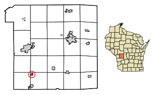
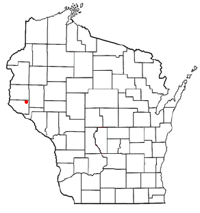
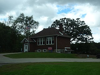
Yuba is a village in Richland County, Wisconsin, United States. The population was 74 at the 2010 census. Yuba is 11 miles southwest of Hillsboro and 17 miles north of Richland Center. County Hwy C runs through the village.

Wilton is a town in Monroe County, Wisconsin, United States. The population was 925 at the 2008 census. The Village of Wilton is located partially within the town.

Merrimac, Wisconsin Village in Wisconsin, United States

Merrimac is a village in Sauk County, Wisconsin, United States, northwest of Madison. The population was 420 at the 2010 census. The village is located within the Town of Merrimac.

References

  1. "2019 U.S. Gazetteer Files". United States Census Bureau. Retrieved August 7, 2020.
  2. 1 2 "US Board on Geographic Names". United States Geological Survey. 2007-10-25. Retrieved 2008-01-31.
  3. 1 2 "U.S. Census website". United States Census Bureau . Retrieved 2012-11-18.
  4. 1 2 "Population and Housing Unit Estimates". United States Census Bureau. May 24, 2020. Retrieved May 27, 2020.
  5. 1 2 "U.S. Census website". United States Census Bureau . Retrieved 2008-01-31.
  6. "US Gazetteer files: 2010, 2000, and 1990". United States Census Bureau. 2011-02-12. Retrieved 2011-04-23.
  7. "US Gazetteer files 2010". United States Census Bureau . Retrieved 2012-11-18.
  8. "Census of Population and Housing". Census.gov. Retrieved June 4, 2015.

Commons-logo.svg Media related to Wilton, Wisconsin at Wikimedia Commons