Warrens, Wisconsin

Last updated

Warrens, Wisconsin
Warrens, Wisconsin.jpg
Monroe County Wisconsin Incorporated and Unincorporated areas Warrens Highlighted.svg
Location of Warrens in Monroe County, Wisconsin.
Coordinates: 44°7′49″N90°30′3″W / 44.13028°N 90.50083°W / 44.13028; -90.50083
Country Flag of the United States.svg  United States
State Flag of Wisconsin.svg  Wisconsin
County Monroe
Area
[1]
  Total1.50 sq mi (3.89 km2)
  Land1.48 sq mi (3.84 km2)
  Water0.02 sq mi (0.05 km2)
Elevation
[2]
1,017 ft (310 m)
Population
 (2020) [3]
  Total544
  Density235.33/sq mi (90.86/km2)
Time zone UTC-6 (Central (CST))
  Summer (DST) UTC-5 (CDT)
Area code 608
FIPS code 55-83450 [4]
GNIS feature ID1576222 [2]

Warrens is a village in Monroe County, Wisconsin, United States off I-94. The population was 544 at the 2020 census.

Contents

Geography

Warrens is located at 44°7′49″N90°30′3″W / 44.13028°N 90.50083°W / 44.13028; -90.50083 (44.130347, -90.500699). [5]

According to the United States Census Bureau, the village has a total area of 1.47 square miles (3.81 km2), of which, 1.45 square miles (3.76 km2) of it is land and 0.02 square miles (0.05 km2) is water. [6]

Demographics

Historical population
CensusPop.Note
1980 300
1990 34314.3%
2000 286−16.6%
2010 36326.9%
2020 54449.9%
U.S. Decennial Census [7]

2010 census

As of the census [3] of 2010, there were 363 people, 154 households, and 96 families living in the village. The population density was 250.3 inhabitants per square mile (96.6/km2). There were 375 housing units at an average density of 258.6 per square mile (99.8/km2). The racial makeup of the village was 94.5% White, 1.1% African American, 1.9% Native American, and 2.5% from two or more races. Hispanic or Latino of any race were 0.8% of the population.

There were 154 households, of which 35.1% had children under the age of 18 living with them, 48.7% were married couples living together, 11.0% had a female householder with no husband present, 2.6% had a male householder with no wife present, and 37.7% were non-families. 32.5% of all households were made up of individuals, and 19.4% had someone living alone who was 65 years of age or older. The average household size was 2.36 and the average family size was 3.03.

The median age in the village was 37.5 years. 25.3% of residents were under the age of 18; 7.7% were between the ages of 18 and 24; 23.9% were from 25 to 44; 28.2% were from 45 to 64; and 14.9% were 65 years of age or older. The gender makeup of the village was 50.1% male and 49.9% female.

2000 census

As of the census [4] of 2000, there were 286 people, 113 households, and 76 families living in the village. The population density was 484.5 people per square mile (187.2/km2). There were 128 housing units at an aver had children under the age of 18 living with them, 47.8% were married couples living together, 13.3% had a female householder with no husband present, and 32.7% were non-families. 24.8% of all households were made up of individuals, and 13.3% had someone living alone who was 65 years of age or older. The average household size was 2.53 and the average family size was 3.07.

In the village, the population was spread out, with 26.6% under the age of 18, 10.1% from 18 to 24, 26.6% from 25 to 44, 21.7% from 45 to 64, and 15.0% who were 65 years of age or older. The median age was 36 years. For every 100 females, there were 95.9 males. For every 100 females age 18 and over, there were 94.4 males.

The median income for a household in the village was $29,464, and the median income for a family was $37,500. Males had a median income of $26,932 versus $16,607 for females. The per capita income for the village was $13,005. About 1.4% of families and 10.7% of the population were below the poverty line, including 11.1% of those under the age of eighteen and 18.4% of those 65 or over.

Economy

Cranberry farm near Warrens Cranberry farm.jpg
Cranberry farm near Warrens
Warrens Cranberry Festival building WarrensCranberryFestivalBuildingWisconsin.jpg
Warrens Cranberry Festival building

Warrens is the hub of a cranberry-growing region. The population of the small village of Warrens swells to over 100,000 each September when it hosts the annual Warrens Cranberry Festival. One of the largest such festivals in the country, Cranfest is held annually during the last full weekend of September. The festival includes over 100 farmers' market booths, 350 antique and flea market vendors, 800 arts and craft vendors, and Wisconsin's largest marching band parade. Due to the Coronavirus Pandemic of 2020, Cranfest was cancelled, with plans to hold a festival in 2021. [8]

Images

Related Research Articles

<span class="mw-page-title-main">Cranberry Isles, Maine</span> Town in the state of Maine, United States

Cranberry Isles is a town in Hancock County, Maine, United States. The population was 160 at the 2020 census.

Blind Lake Township is a township in Cass County, Minnesota, United States. The population was 88 as of the 2000 census.

Deerfield Township is a township in Cass County, Minnesota, United States. The population was 154 as of the 2000 census. Deerfield Township was named for the large population of deer within its borders.

Trelipe Township is a township in Cass County, Minnesota, United States. The population was 174 as of the 2000 census. Trelipe Township was named for the freshwater fish Coregonus artedi, commonly known as the tullibee.

Pembina Township is a township in Mahnomen County, Minnesota in the United States. The population was 471 at the 2000 census.

<span class="mw-page-title-main">Elgin, Minnesota</span> City in Minnesota, United States

Elgin is a city in Wabasha County, Minnesota, United States on Minnesota State Highway 42. The population was 1,089 at the 2010 census. Its annual festival is Elgin Cheese Days.

<span class="mw-page-title-main">Clifton, New York</span> Town in New York, United States

Clifton is a town in St. Lawrence County, New York, United States. The population was 675 at the 2020 census. The town takes its name from a mining company.

<span class="mw-page-title-main">New Washington, Ohio</span> Village in Ohio, United States

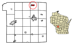
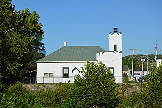
New Washington is a village in Cranberry Township in Crawford County, Ohio, United States. The population was 873 at the 2020 census.

<span class="mw-page-title-main">Lowellville, Ohio</span> Village in Ohio, United States

Lowellville is a village in eastern Mahoning County, Ohio, United States, along the Mahoning River. The population was 996 at the 2020 census. Located about 8 miles (13 km) southeast of Youngstown, it is part of the Youngstown–Warren metropolitan area.

<span class="mw-page-title-main">Cloverdale, Ohio</span> Village in Ohio, United States

Cloverdale is a village in Perry Township, Putnam County, Ohio, United States. The population was 170 at the 2020 census.

<span class="mw-page-title-main">Dupont, Ohio</span> Village in Ohio, United States

Dupont is a village in Putnam County, Ohio, United States. The population was 212 at the 2020 census.

<span class="mw-page-title-main">Orangeville, Ohio</span> Village in Ohio, United States

Orangeville is a village in eastern Trumbull County, Ohio, United States, along the state line with Pennsylvania. The population was 174 at the 2020 census. It is part of the Youngstown–Warren metropolitan area.

<span class="mw-page-title-main">Butlerville, Ohio</span> Village in Ohio, United States

Butlerville is a village in central Harlan Township, Warren County, Ohio, United States, located in the southwestern part of the state. The population was 155 at the 2020 census.

<span class="mw-page-title-main">Corwin, Ohio</span> Village in Ohio, United States

Corwin is a village in Wayne Township, Warren County, Ohio, United States. The population was 484 at the 2020 census.

<span class="mw-page-title-main">Morrow, Ohio</span> Village in Ohio, United States

Morrow is a village in Salem Township, Warren County, Ohio, United States. The population was 2,049 at the 2020 census.

<span class="mw-page-title-main">Pleasant Plain, Ohio</span> Village in Ohio, United States

Pleasant Plain is a village in Harlan Township, Warren County, Ohio, United States. The population was 129 at the 2020 census.

<span class="mw-page-title-main">South Lebanon, Ohio</span> City in Ohio, United States

South Lebanon is a city located in Union and Hamilton Townships in central Warren County in the southwestern part of the U.S. state of Ohio. The population was 6,384 at the 2020 census.

<span class="mw-page-title-main">Fernway, Pennsylvania</span> Former census-designated place in Pennsylvania, United States

Fernway is a neighborhood in Cranberry Township, Butler County, Pennsylvania, United States. It includes 458 homes on 183 acres and was the first planned housing subdivision in the Township, dating back to the 1950s. Fernway was formerly used as the name of a census-designated place (CDP), but the designation was removed as of TIGER 2013 after Cranberry Township officials pointed out that users of Internet mapping websites frequently misinterpreted the CDP as the name of its parent municipality.

Larga Vista is a former census-designated place (CDP) in Webb County, Texas, United States. The population was 742 at the 2000 census. Larga Vista lost its census-designated place status in 2010 because it became surrounded by Laredo. A CDP may not be located, either partially or entirely, within an incorporated place or another CDP. Today, Larga Vista is considered a Laredo neighborhood.

<span class="mw-page-title-main">New Castle, Virginia</span> Town in Virginia, United States

New Castle is the only town in Craig County, Virginia, United States. The population was 125 at the 2020 census. It is the county seat of Craig County.

References

  1. "2019 U.S. Gazetteer Files". United States Census Bureau. Retrieved August 7, 2020.
  2. 1 2 "US Board on Geographic Names". United States Geological Survey. October 25, 2007. Retrieved January 31, 2008.
  3. 1 2 "U.S. Census website". United States Census Bureau . Retrieved November 18, 2012.
  4. 1 2 "U.S. Census website". United States Census Bureau . Retrieved January 31, 2008.
  5. "US Gazetteer files: 2010, 2000, and 1990". United States Census Bureau. February 12, 2011. Retrieved April 23, 2011.
  6. "US Gazetteer files 2010". United States Census Bureau . Retrieved November 18, 2012.
  7. "Census of Population and Housing". Census.gov. Retrieved June 4, 2015.
  8. Cranfest - Welcome to Cranfest Online!