Melvina, Wisconsin

Last updated

Melvina, Wisconsin
Melvina, Wisconsin.jpg
Monroe County Wisconsin Incorporated and Unincorporated areas Melvina Highlighted.svg
Location of Melvina in Monroe County, Wisconsin.
Coordinates: 43°48′6″N90°46′31″W / 43.80167°N 90.77528°W / 43.80167; -90.77528
Country Flag of the United States.svg  United States
State Flag of Wisconsin.svg  Wisconsin
County Monroe
Area
[1]
  Total0.49 sq mi (1.26 km2)
  Land0.49 sq mi (1.26 km2)
  Water0.00 sq mi (0.00 km2)
Elevation
[2]
863 ft (263 m)
Population
 (2020) [3]
  Total93
  Density226.34/sq mi (87.48/km2)
Time zone UTC-6 (Central (CST))
  Summer (DST) UTC-5 (CDT)
Area code 608
FIPS code 55-50800 [4]
GNIS feature ID1569329 [2]

Melvina is a village in Monroe County, Wisconsin, United States. The population was 93 at the 2020 census.

Contents

History

The story of Melvina began when Vernon County miller Charles A. Hunt returned from the Civil War and sold all his interests in that county. He used the funds to buy 300 acres of land in Monroe County, including the present site of the village of Melvina. He built a mill at that site and persuaded other families to come and settle there. He named the settlement "Melvina" after his recently deceased wife, Amanda Melvina Hunt ( née Ray). [5]

Geography

Melvina is located at 43°48′6″N90°46′31″W / 43.80167°N 90.77528°W / 43.80167; -90.77528 (43.801747, -90.775267). [6]

According to the United States Census Bureau, the village has a total area of 0.48 square miles (1.24 km2), all of it land. [7]

Demographics

Historical population
CensusPop.Note
1930 143
1940 135−5.6%
1950 121−10.4%
1960 111−8.3%
1970 1164.5%
1980 1170.9%
1990 115−1.7%
2000 93−19.1%
2010 10411.8%
2020 93−10.6%
U.S. Decennial Census [8]

2010 census

As of the census [3] of 2010, there were 104 people, 39 households, and 26 families living in the village. The population density was 216.7 inhabitants per square mile (83.7/km2). There were 44 housing units at an average density of 91.7 per square mile (35.4/km2). The racial makeup of the village was 96.2% White, 1.9% African American, and 1.9% from two or more races.

There were 39 households, of which 38.5% had children under the age of 18 living with them, 43.6% were married couples living together, 15.4% had a female householder with no husband present, 7.7% had a male householder with no wife present, and 33.3% were non-families. 33.3% of all households were made up of individuals, and 7.7% had someone living alone who was 65 years of age or older. The average household size was 2.67 and the average family size was 3.31.

The median age in the village was 29.4 years. 33.7% of residents were under the age of 18; 7.7% were between the ages of 18 and 24; 33.6% were from 25 to 44; 19.2% were from 45 to 64; and 5.8% were 65 years of age or older. The gender makeup of the village was 49.0% male and 51.0% female.

2000 census

As of the census [4] of 2000, there were 93 people, 38 households, and 25 families living in the village. The population density was 195.6 people per square mile (74.8/km2). There were 41 housing units at an average density of 86.2 per square mile (33.0/km2). The racial makeup of the village was 97.85% White, 1.08% Native American, and 1.08% from two or more races.

There were 38 households, out of which 31.6% had children under the age of 18 living with them, 47.4% were married couples living together, 10.5% had a female householder with no husband present, and 34.2% were non-families. 31.6% of all households were made up of individuals, and 10.5% had someone living alone who was 65 years of age or older. The average household size was 2.45 and the average family size was 3.12.

In the village, the population was spread out, with 33.3% under the age of 18, 5.4% from 18 to 24, 30.1% from 25 to 44, 18.3% from 45 to 64, and 12.9% who were 65 years of age or older. The median age was 35 years. For every 100 females, there were 86.0 males. For every 100 females age 18 and over, there were 87.9 males.

The median income for a household in the village was $21,250, and the median income for a family was $28,750. Males had a median income of $21,563 versus $18,281 for females. The per capita income for the village was $11,791. There were 12.5% of families and 17.5% of the population living below the poverty line, including 21.2% of under eighteens and 18.2% of those over 64.

Related Research Articles

<span class="mw-page-title-main">Buchanan, Georgia</span> City in Georgia, United States

Buchanan is a city and the county seat of Haralson County, Georgia, United States. The population was 1,104 at the 2010 census, up from 941 at the 2000 census.

<span class="mw-page-title-main">Deepwater, Missouri</span> City in Missouri, United States

Deepwater is a city in Henry County, Missouri, United States. The population was 433 at the 2010 census.

<span class="mw-page-title-main">Cloverdale, Ohio</span> Village in Ohio, United States

Cloverdale is a village in Perry Township, Putnam County, Ohio, United States. The population was 170 at the 2020 census.

<span class="mw-page-title-main">Bellevue, Wisconsin</span> Village in Wisconsin, United States

Bellevue is a village in Brown County, Wisconsin. It was a town until incorporating as a village on February 14, 2003. The population was 15,935 at the time of the 2020 census. Bellevue is part of the Green Bay metropolitan area. Bellevue sits around 4.34 miles (6.99 km) east from central Green Bay.

<span class="mw-page-title-main">Bell Center, Wisconsin</span> Village in Wisconsin, United States

Bell Center is a village in Crawford County, Wisconsin, United States. The population was 117 at the 2010 census.

<span class="mw-page-title-main">Steuben, Wisconsin</span> Village in Wisconsin, United States

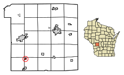
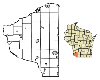
Steuben is a village in Crawford County, Wisconsin, United States. The population was 131 at the 2010 census.

<span class="mw-page-title-main">Kekoskee, Wisconsin</span> Village in Wisconsin, United States

Kekoskee is a village in Dodge County, Wisconsin, United States. The population was 161 at the 2010 census.

<span class="mw-page-title-main">Fairwater, Wisconsin</span> Village in Wisconsin, United States

Fairwater is a village in Fond du Lac County, Wisconsin, United States. The population was 371 at the 2010 census. The town of Metomen surrounds the village.

<span class="mw-page-title-main">Blue River, Wisconsin</span> Village in Wisconsin, United States

Blue River is a village in Grant County, Wisconsin, United States. The population was 434 at the 2010 census.

<span class="mw-page-title-main">Avoca, Wisconsin</span> Village in Wisconsin, United States

Avoca is a village in Iowa County, Wisconsin, United States. The population was 637 at the 2010 census. It is part of the Madison Metropolitan Statistical Area. It is named after Avoca in Ireland.

<span class="mw-page-title-main">Boaz, Wisconsin</span> Village in Wisconsin, United States

Boaz is a village in Richland County, Wisconsin, United States. According to the 2010 census, the population of the village was 156.

<span class="mw-page-title-main">Yuba, Wisconsin</span> Village in Wisconsin, United States

Yuba is a village in Richland County, Wisconsin, United States. The population was 74 at the 2010 census. Yuba is 11 miles southwest of Hillsboro and 17 miles north of Richland Center. County Hwy C runs through the village.

<span class="mw-page-title-main">Eastman, Wisconsin</span> Village in Wisconsin, United States

Eastman is a village in Crawford County, Wisconsin, United States. The population was 428 at the 2010 census. The village is located within the Town of Eastman.

<span class="mw-page-title-main">Mount Hope, Wisconsin</span> Village in Wisconsin, United States

Mount Hope is a village in Grant County, Wisconsin, United States. The population was 225 at the 2010 census. The village is located within the Town of Mount Hope.

<span class="mw-page-title-main">Woodman, Wisconsin</span> Village in Wisconsin, United States

Woodman is a village in Grant County in the U.S. state of Wisconsin. The population was 132 at the 2010 census. The village is located within the Town of Woodman.

<span class="mw-page-title-main">Marquette, Wisconsin</span> Village in Wisconsin, United States

Marquette is a village in Green Lake County, Wisconsin, United States. The population was 150 at the 2010 census. The village is located within the Town of Marquette. Marquette uses the postal code 53947.

<span class="mw-page-title-main">Arena, Wisconsin</span> Village in Wisconsin, United States

Arena is a village in Iowa County, Wisconsin, United States. The population was 834 at the 2010 census. The village is located within the Town of Arena. It is part of the Madison Metropolitan Statistical Area.

<span class="mw-page-title-main">Wilton, Wisconsin</span> Village in Wisconsin, United States

Wilton is a village in Monroe County, Wisconsin, United States. The population was 504 at the 2010 census. The village is located partially within the Town of Wilton and partially within the Town of Wellington.

<span class="mw-page-title-main">Rudolph, Wisconsin</span> Village in Wisconsin, United States

Rudolph is a village in Wood County, Wisconsin, United States. The population was 439 at the 2010 census. The village is located within the Town of Rudolph.

<span class="mw-page-title-main">Jefferson Valley, New York</span> Census-designated place in New York, United States

Jefferson Valley-Yorktown, commonly known as Jefferson Valley, is a census-designated place (CDP) located in the town of Yorktown in Westchester County, New York, United States. The population was 14,142 at the 2010 census. It is a hot spot for local shoppers, due to its Jefferson Valley Mall.

References

  1. "2019 U.S. Gazetteer Files". United States Census Bureau. Retrieved August 7, 2020.
  2. 1 2 "US Board on Geographic Names". United States Geological Survey. October 25, 2007. Retrieved January 31, 2008.
  3. 1 2 "U.S. Census website". United States Census Bureau . Retrieved November 18, 2012.
  4. 1 2 "U.S. Census website". United States Census Bureau . Retrieved January 31, 2008.
  5. History of Monroe County Wisconsin, Past and Present. C. F. Cooper & Co. 1912. p.  510 . Retrieved June 17, 2022.
  6. "US Gazetteer files: 2010, 2000, and 1990". United States Census Bureau. February 12, 2011. Retrieved April 23, 2011.
  7. "US Gazetteer files 2010". United States Census Bureau. Archived from the original on July 2, 2012. Retrieved November 18, 2012.
  8. "Census of Population and Housing". Census.gov. Retrieved February 15, 2023.