Wyeville, Wisconsin

Last updated

Wyeville, Wisconsin
Wyeville, Wisconsin.jpg
Monroe County Wisconsin Incorporated and Unincorporated areas Wyeville Highlighted.svg
Location of Wyeville in Monroe County, Wisconsin.
Coordinates: 44°1′40″N90°23′9″W / 44.02778°N 90.38583°W / 44.02778; -90.38583
Country Flag of the United States.svg  United States
State Flag of Wisconsin.svg  Wisconsin
County Monroe
Area
[1]
  Total0.56 sq mi (1.46 km2)
  Land0.56 sq mi (1.46 km2)
  Water0.00 sq mi (0.00 km2)
Elevation
[2]
919 ft (280 m)
Population
 (2010) [3]
  Total147
  Estimate 
(2019) [4]
143
  Density253.10/sq mi (97.78/km2)
Time zone UTC-6 (Central (CST))
  Summer (DST) UTC-5 (CDT)
Area code 608
FIPS code 55-89275 [5]
GNIS feature ID1577062 [2]

Wyeville is a village in Monroe County, Wisconsin, United States. It is located on Wisconsin Highway 21. [6] The population was 147 at the 2010 census.

Contents

History

The West Wisconsin Railway was authorized in 1876 to build from St. Paul, Minnesota through to reach the Chicago and North Western Railway at Elroy, Wisconsin. [7] This railroad became the Chicago, St. Paul, Minneapolis and Omaha Railway ("The Omaha Road") in 1880. At this location, a branch rail line was constructed eastward to Necedah. The location originally was named "Necedah Junction". The local post office was called Wyeville when established in 1890 and the first postmaster was Charles Brooks. [8] [9] The name Wyeville is documented as a variation of "Wythe", a county in Virginia. [10] Eventually the name "Necedah Junction" was dropped in 1911 and the community was called the same name as the post office.

The railway junction became a crossing in 1911 for the lines of the Chicago and North Western Railway and its Omaha Road subsidiary. [11] The Milwaukee, Sparta, and Northwestern Railroad, a subsidiary of the Chicago and North Western Railway, began the "Air Line" or "Adams Cutoff" from Adams, Wisconsin towards Sparta, Wisconsin in 1910. [12] This railroad used the line from Necedah to Wyeville as part of this new route. A true railroad wye was built at the railroad crossover, along with an interlocking tower and railroad depot. [11]

Until 1963, passengers of Twin Cities 400 and the Rochester 400 changed trains there, as it was a scheduled transfer point for the two streamliners. [13] [14] [15]

Geography

According to the United States Census Bureau, the village has a total area of 0.59 square miles (1.53 km2), all of it land. [16]

Demographics

Historical population
CensusPop.Note
1930 140
1940 21956.4%
1950 195−11.0%
1960 22012.8%
1970 203−7.7%
1980 163−19.7%
1990 154−5.5%
2000 146−5.2%
2010 1470.7%
2019 (est.)143 [4] −2.7%
U.S. Decennial Census [17]

2010 census

As of the census [3] of 2010, there were 147 people, 62 households, and 38 families living in the village. The population density was 249.2 inhabitants per square mile (96.2/km2). There were 70 housing units at an average density of 118.6 per square mile (45.8/km2). The racial makeup of the village was 95.9% White, 1.4% Native American, 0.7% from other races, and 2.0% from two or more races. Hispanic or Latino of any race were 1.4% of the population.

There were 62 households, of which 25.8% had children under the age of 18 living with them, 50.0% were married couples living together, 6.5% had a female householder with no husband present, 4.8% had a male householder with no wife present, and 38.7% were non-families. 22.6% of all households were made up of individuals, and 8.1% had someone living alone who was 65 years of age or older. The average household size was 2.37 and the average family size was 2.79.

The median age in the village was 43.5 years. 21.1% of residents were under the age of 18; 8.1% were between the ages of 18 and 24; 25.8% were from 25 to 44; 28.5% were from 45 to 64; and 16.3% were 65 years of age or older. The gender makeup of the village was 53.7% male and 46.3% female.

2000 census

As of the census [5] of 2000, there were 146 people, 56 households, and 39 families living in the village. The population density was 245.7 people per square mile (95.5/km2). There were 60 housing units at an average density of 101.0 per square mile (39.3/km2). The racial makeup of the village was 93.84% White, 3.42% Native American, 2.74% from other races. Hispanic or Latino of any race were 2.74% of the population.

There were 56 households, out of which 30.4% had children under the age of 18 living with them, 57.1% were married couples living together, 7.1% had a female householder with no husband present, and 28.6% were non-families. 25.0% of all households were made up of individuals, and 19.6% had someone living alone who was 65 years of age or older. The average household size was 2.61 and the average family size was 3.15.

In the village, the population was spread out, with 29.5% under the age of 18, 6.2% from 18 to 24, 30.8% from 25 to 44, 21.9% from 45 to 64, and 11.6% who were 65 years of age or older. The median age was 37 years. For every 100 females, there were 105.6 males. For every 100 females age 18 and over, there were 87.3 males.

The median income for a household in the village was $38,750, and the median income for a family was $44,531. Males had a median income of $33,750 versus $27,813 for females. The per capita income for the village was $14,344. There were 9.8% of families and 13.1% of the population living below the poverty line, including 25.5% of under eighteens and 9.5% of those over 64.

Looking west in downtown Wyeville on Wisconsin Highway 21 Wyeville Wisconsin Downtown Looking West WIS21.jpg
Looking west in downtown Wyeville on Wisconsin Highway 21
Wyeville Elementary School Wyeville Wisconsin Elementary School.jpg
Wyeville Elementary School
Sign on WIS 21 Wyeville Wisconsin Sign WIS21.jpg
Sign on WIS 21

Notable people

Related Research Articles

<span class="mw-page-title-main">Luzerne, Iowa</span> City in Iowa, United States

Luzerne is a city in Benton County, Iowa, United States. The population was 112 at the time of the 2020 census. It is part of the Cedar Rapids Metropolitan Statistical Area.

<span class="mw-page-title-main">Powers, Michigan</span> Village in Michigan, United States

Powers is a village in Menominee County in the U.S. state of Michigan. The population was 381 at the 2020 census, down from 422 in 2010. Located within Spalding Township, it is part of the Marinette micropolitan area.

<span class="mw-page-title-main">Redfield, South Dakota</span> City in South Dakota, United States

Redfield is a city in and the county seat of Spink County, South Dakota, United States. The population was 2,214 at the 2020 census. The city was named for J. B. Redfield, a railroad official.

<span class="mw-page-title-main">Nashville, Wisconsin</span> Town in Wisconsin, United States

Nashville is a town in Forest County, Wisconsin, United States. The population was 1,064 at the 2010 census. The Mole Lake Indian Reservation is located within the town. The town is named after G.V. Nash of Forest City, Arkansas.

<span class="mw-page-title-main">Elroy, Wisconsin</span> City in Wisconsin, United States

Elroy is a city in Juneau County, Wisconsin, United States, along the Baraboo River and at the east end of the Elroy-Sparta Bike Trail. The population was 1,356 at the 2020 census.

<span class="mw-page-title-main">West Salem, Wisconsin</span> Village in Wisconsin, United States

West Salem is a village in La Crosse County, Wisconsin, United States, along the La Crosse River. It is part of the La Crosse-Onalaska, WI-MN Metropolitan Statistical Area. The population was 5,277 as of the 2020 census.

<span class="mw-page-title-main">Cleveland (village), Wisconsin</span> Village in Wisconsin, United States

Cleveland is a village in Manitowoc County, Wisconsin, United States. The population was 1,579 at the 2020 census.

<span class="mw-page-title-main">Fenwood, Wisconsin</span> Village in Wisconsin, United States

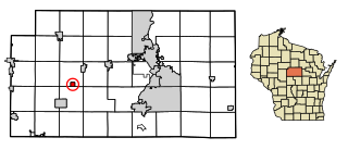
Fenwood is a village in Marathon County, Wisconsin, United States. It is part of the Wausau, Wisconsin Metropolitan Statistical Area. The population was 152 at the 2010 census.

<span class="mw-page-title-main">Stratford, Wisconsin</span> Village in Wisconsin, United States

Stratford is a village in Marathon County, Wisconsin, United States. It is part of the Wausau, Wisconsin Metropolitan Statistical Area. The population was 1,578 at the 2010 census.

<span class="mw-page-title-main">Norwalk, Wisconsin</span> Village in Wisconsin, United States

Norwalk is a village in Monroe County, Wisconsin, United States. The population was 611 at the 2020 census.

<span class="mw-page-title-main">Footville, Wisconsin</span> Village in Wisconsin, United States

Footville is a village in Rock County, Wisconsin, United States. The population was 772 at the 2020 census.

<span class="mw-page-title-main">Eland, Wisconsin</span> Village in Wisconsin, United States

Eland is a village in Shawano County, Wisconsin, in the United States. The population was 202 at the 2010 census.

<span class="mw-page-title-main">Tigerton, Wisconsin</span> Village in Wisconsin, United States

Tigerton is a village in Shawano County, Wisconsin, United States. The population was 741 at the 2010 census.

<span class="mw-page-title-main">Glenbeulah, Wisconsin</span> Village in Wisconsin, United States

Glenbeulah is a village in Sheboygan County, Wisconsin, United States. The population was 463 at the 2010 census. It is included in the Sheboygan, Wisconsin Metropolitan Statistical Area. Glenbeulah is situated on the Mullet River.

<span class="mw-page-title-main">Eden, Wisconsin</span> Village in Wisconsin, United States

Eden is a village in Fond du Lac County, Wisconsin, United States. The population was 875 at the 2010 census. The village is located within the Town of Eden.

<span class="mw-page-title-main">Woodman, Wisconsin</span> Village in Wisconsin, United States

Woodman is a village in Grant County in the U.S. state of Wisconsin. The population was 132 at the 2010 census. The village is located within the Town of Woodman.

<span class="mw-page-title-main">Necedah, Wisconsin</span> Village in Wisconsin, United States

Necedah is a village in Juneau County, Wisconsin, United States. The population was 916 at the 2020 census. The village is located within the Town of Necedah.

<span class="mw-page-title-main">Ellsworth, Wisconsin</span> Village in Wisconsin, United States

Ellsworth is a village in and the county seat of Pierce County, Wisconsin, United States. The population was 3,348 at the 2020 census. The village is adjacent to the Town of Ellsworth and now incorporates the formerly separate district known as East Ellsworth. The municipality of Ellsworth and its surroundings are slowly becoming incorporated into the Twin Cities Metro Area.

<span class="mw-page-title-main">Baldwin, Wisconsin</span> Village in Wisconsin, United States

Baldwin is a village in St. Croix County, Wisconsin, United States. The population was 3,957 at the 2010 census, a growth rate of 48% from 2000. The village is adjacent to the Town of Baldwin.

<span class="mw-page-title-main">Spooner, Wisconsin</span> City in Wisconsin, United States

Spooner is a city in Washburn County, Wisconsin, United States. The population was 2,573 at the 2020 census. The city is located mostly within the southwest corner of the Town of Spooner, with a small portion extending into the Town of Beaver Brook on the south, the Town of Bashaw on the southwest, and the Town of Evergreen on the west. The city's nickname, Crossroads of the North, is a reference to the city's location at the junction of two U.S. highways, 53 and 63, and State Highways 70 and 253.

References

  1. "2019 U.S. Gazetteer Files". United States Census Bureau. Retrieved August 7, 2020.
  2. 1 2 "US Board on Geographic Names". United States Geological Survey. October 25, 2007. Retrieved January 31, 2008.
  3. 1 2 "U.S. Census website". United States Census Bureau . Retrieved November 18, 2012.
  4. 1 2 "Population and Housing Unit Estimates". United States Census Bureau. May 24, 2020. Retrieved May 27, 2020.
  5. 1 2 "U.S. Census website". United States Census Bureau . Retrieved January 31, 2008.
  6. 2001-2 Official Wisconsin State Highway Map
  7. Yesterday and Today: A History of the Chicago and North Western Railway System. Winship Company, Printers. 1910. pp.  77–.
  8. New England Railway Publishing Company (1892). Pathfinder Shipping and Mailing Guide. New England Railway Publishing Company. pp. 635–.
  9. Edward Callary (2016). Place Names of Wisconsin. University of Wisconsin Press. ISBN   978-0-299-30964-0. Note: re-ref to Stennett book, and Callary cites Stennett as "usually quite reliable in these matters."
  10. Stennett, W.H. (an officer with Chicago and North Western Railway Company for more than 34 years) (1908). A History of the Origin of the Place Names Connected with the Chicago & North Western and Chicago, St. Paul, Minneapolis & Omaha Railways (2nd ed.). Chicago. p.  141.{{cite book}}: CS1 maint: numeric names: authors list (link)
  11. 1 2 Railway Track and Structures: RT & S. Simmons-Boardman Publishing Corporation. 1912. pp. 294–.
  12. History of Monroe County, Wisconsin: Past and Present Including an Account of the Cities, Towns and Villages of the County. Unigraphic. 1912.
  13. Chicago and Northwestern Railway Timetable, 1962.
  14. Scribbins, Jim (2008) [1982]. The 400 Story. Minneapolis, Minnesota: University of Minnesota Press. ISBN   978-0-8166-5449-9. pp. 81, 98 (photograph of transfers), 203-06 (discontinuance).
  15. Official Guide of Railways Feb. 1961 Chicago and North Western Railway Pg. 661 Table 1
  16. "US Gazetteer files 2010". United States Census Bureau. Archived from the original on February 20, 2011. Retrieved November 18, 2012.
  17. "Census of Population and Housing". Census.gov. Retrieved June 4, 2015.
  18. 'Wisconsin Blue Book 1970,' Biographical Sketch of Kyle Kenyon, pg. 58