Chest Springs, Pennsylvania

Last updated
Chest Springs, Pennsylvania
Borough
Columbia in Chest Springs.jpg
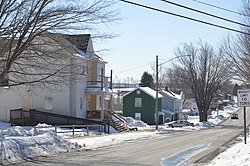
Houses on Columbia Street
Cambria County Pennsylvania Incorporated and Unincorporated areas Chest Springs Highlighted.svg
Location of Chest Springs in Cambria County, Pennsylvania.
USA Pennsylvania location map.svg
Red pog.svg
Chest Springs
Coordinates: 40°34′44″N78°36′35″W / 40.57889°N 78.60972°W / 40.57889; -78.60972 Coordinates: 40°34′44″N78°36′35″W / 40.57889°N 78.60972°W / 40.57889; -78.60972
Country United States
State Pennsylvania
County Cambria
Incorporated1858
Government
  TypeBorough Council
  MayorPaul Eckenrode
Area
[1]
  Total0.19 sq mi (0.50 km2)
  Land0.19 sq mi (0.50 km2)
  Water0.00 sq mi (0.00 km2)
Elevation
[2]
1,942 ft (592 m)
Population
 (2020) [3]
  Total140
  Density725.39/sq mi (280.42/km2)
Time zone UTC-5 (Eastern (EST))
  Summer (DST) UTC-4 (EDT)
Zip code
16624
Area code 814
FIPS code 42-13384
GNIS feature ID1215013 [2]

Chest Springs is a borough in Cambria County, Pennsylvania, United States. It is part of the Johnstown, Pennsylvania Metropolitan Statistical Area. The population was 149 at the 2010 census. [4]

Contents

Geography

Chest Springs is located in northeastern Cambria County at 40°34′44″N78°36′35″W / 40.57889°N 78.60972°W / 40.57889; -78.60972 (40.578804, -78.609807). [5]

According to the United States Census Bureau, the borough has a total area of 0.19 square miles (0.5 km2), all of it land. [4]

Demographics

Historical population
CensusPop.
1860 183
1870 26947.0%
1880 30513.4%
1890 255−16.4%
1900 202−20.8%
1910 174−13.9%
1920 126−27.6%
1930 16127.8%
1940 18313.7%
1950 23226.8%
1960 215−7.3%
1970 178−17.2%
1980 19811.2%
1990 166−16.2%
2000 110−33.7%
2010 14935.5%
2020 140−6.0%
Sources: [6] [7] [8] [3]

At the 2000 census there were 110 people, 50 households, and 30 families in the borough. The population density was 476.9 people per square mile (184.7/km²). There were 50 housing units at an average density of 216.8 per square mile (83.9/km²). The racial makeup of the borough was 100.00% White. [7] There were 50 households, 30.0% had children under the age of 18 living with them, 44.0% were married couples living together, 8.0% had a female householder with no husband present, and 40.0% were non-families. 36.0% of households were made up of individuals, and 18.0% were one person aged 65 or older. The average household size was 2.20 and the average family size was 2.93.

The age distribution was 23.6% under the age of 18, 8.2% from 18 to 24, 28.2% from 25 to 44, 20.9% from 45 to 64, and 19.1% 65 or older. The median age was 40 years. For every 100 females there were 100.0 males. For every 100 females age 18 and over, there were 104.9 males.

The median household income was $23,750 and the median family income was $38,750. Males had a median income of $35,000 versus $26,250 for females. The per capita income for the borough was $14,357. There were no families and 3.7% of the population living below the poverty line, including no under eighteens and 8.7% of those over 64.

Related Research Articles

<span class="mw-page-title-main">Brownstown, Cambria County, Pennsylvania</span> Borough in Pennsylvania, United States

Brownstown is a borough in Cambria County, Pennsylvania, United States. The population was 744 at the 2010 census. It is part of the Johnstown, Pennsylvania Metropolitan Statistical Area and also part of Johnstown's urban area.

<span class="mw-page-title-main">Carrolltown, Pennsylvania</span> Borough in Pennsylvania, United States

Carrolltown is a borough in Cambria County, Pennsylvania, United States. The population was 853 at the 2010 census, down from 1,049 at the 2000 census. It is part of the Johnstown, Pennsylvania Metropolitan Statistical Area.

<span class="mw-page-title-main">Chest Township, Cambria County, Pennsylvania</span> Township in Pennsylvania, United States

Chest Township is a township in Cambria County, Pennsylvania, United States. The population was 458 at the 2020 census. It is part of the Johnstown, Pennsylvania Metropolitan Statistical Area.

<span class="mw-page-title-main">Clearfield Township, Cambria County, Pennsylvania</span> Township in Pennsylvania, United States

Clearfield Township is a township in Cambria County, Pennsylvania, United States. The population was 1,608 at the 2020 census. It is part of the Johnstown, Pennsylvania Metropolitan Statistical Area.

<span class="mw-page-title-main">Daisytown, Pennsylvania</span> Borough in Pennsylvania, United States

Daisytown is a borough in Cambria County, Pennsylvania, United States. It is part of the Johnstown, Pennsylvania Metropolitan Statistical Area. The population was 326 at the 2010 census.

<span class="mw-page-title-main">Dale, Pennsylvania</span> Borough in Pennsylvania, United States

Dale is a borough in Cambria County, Pennsylvania, United States. It is part of the Johnstown, Pennsylvania Metropolitan Statistical Area. The population was 1,234 at the 2010 census, down from 1,503 at the 2000 census.

<span class="mw-page-title-main">East Carroll Township, Cambria County, Pennsylvania</span> Township in Pennsylvania, United States

East Carroll Township is a township in Cambria County, Pennsylvania, United States. The population was 1,654 at the 2010 census. It is part of the Johnstown, Pennsylvania Metropolitan Statistical Area.

<span class="mw-page-title-main">Ehrenfeld, Pennsylvania</span> Borough in Pennsylvania, United States

Ehrenfeld is a borough in Cambria County, Pennsylvania, United States. It is part of the Johnstown, Pennsylvania Metropolitan Statistical Area. The population was 228 at the 2010 census.

<span class="mw-page-title-main">Elder Township, Cambria County, Pennsylvania</span> Township in Pennsylvania, United States

Elder Township is a township in Cambria County, Pennsylvania, United States, about 24 miles (39 km) northwest of Altoona. As of the 2010 census, the township had a population of 1,038. It is part of the Johnstown, Pennsylvania Metropolitan Statistical Area.

<span class="mw-page-title-main">Ferndale, Pennsylvania</span> Borough in Pennsylvania, United States

Ferndale is a borough in Cambria County, Pennsylvania, United States. It is part of the Johnstown, Pennsylvania Metropolitan Statistical Area. The population was 1,636 at the 2010 census, down from 1,834 at the 2000 census.

<span class="mw-page-title-main">Geistown, Pennsylvania</span> Borough in Pennsylvania, United States

Geistown is a borough in Cambria County, Pennsylvania, United States. It is part of the Johnstown, Pennsylvania Metropolitan Statistical Area. The population was 2,467 at the 2010 census.

<span class="mw-page-title-main">Hastings, Pennsylvania</span> Borough in Pennsylvania, United States

Hastings is a borough in Cambria County, Pennsylvania, United States. It is part of the Johnstown, Pennsylvania Metropolitan Statistical Area. The population was 1,278 at the 2010 census.

<span class="mw-page-title-main">Loretto, Pennsylvania</span> Borough in Pennsylvania, United States

Loretto is a borough in Cambria County, Pennsylvania. As of the 2010 census it had a population of 1,302. Like the rest of Cambria County, it is part of the Johnstown, Pennsylvania Metropolitan Statistical Area. Loretto is the home of Saint Francis University.

<span class="mw-page-title-main">Patton, Pennsylvania</span> Borough in Pennsylvania, United States

Patton is a borough in Cambria County, Pennsylvania, United States. It is 19 miles (31 km) northwest of Altoona, in an agricultural region. It is part of the Johnstown, Pennsylvania Metropolitan Statistical Area. In 1900, 2,651 people lived here, and in 1910, 3,907 people inhabited Patton. The population was 1,769 at the 2010 census.

<span class="mw-page-title-main">Sankertown, Pennsylvania</span> Borough in Pennsylvania, United States

Sankertown is a borough in Cambria County, Pennsylvania, United States. It is part of the Johnstown, Pennsylvania Metropolitan Statistical Area. The population was 675 at the 2010 census.

<span class="mw-page-title-main">South Fork, Pennsylvania</span> Borough in Pennsylvania, United States

South Fork is a borough in Cambria County, Pennsylvania, United States. It is part of the Johnstown, Pennsylvania Metropolitan Statistical Area. The population was 928 at the 2010 census, down from 1,138 at the 2000 census.

<span class="mw-page-title-main">Spring Hill, Pennsylvania</span>

Spring Hill is a census-designated place (CDP) in Cambria County, Pennsylvania, United States. The population was 839 at the 2010 census, down from 970 at the 2000 census.

<span class="mw-page-title-main">Westover, Pennsylvania</span> Borough in Pennsylvania, United States

Westover is a borough in Clearfield County, Pennsylvania, United States. The population was 359 at the 2020 census.

<span class="mw-page-title-main">Tunnelhill, Pennsylvania</span> Borough in Pennsylvania, United States

Tunnelhill is a borough that is located in both Cambria and Blair counties in Pennsylvania in the United States. The population was 363 at the 2010 census. Of this, 245 were in Cambria County, and 118 were in Blair County. It is part of the Altoona, PA Metropolitan Statistical Area. Tunnelhill is named after the many railroad tunnels of the Pennsylvania Railroad near here known as the Gallitzin Tunnels.

<span class="mw-page-title-main">Franklin, Cambria County, Pennsylvania</span> Borough in Pennsylvania, United States

Franklin is a borough in Cambria County, Pennsylvania, United States. It is part of the Johnstown, Pennsylvania Metropolitan Statistical Area. At the 2010 census the borough population was 323, down from 442 at the 2000 census.

References

  1. "ArcGIS REST Services Directory". United States Census Bureau. Retrieved October 12, 2022.
  2. 1 2 U.S. Geological Survey Geographic Names Information System: Chest Springs, Pennsylvania
  3. 1 2 "Census Population API". United States Census Bureau. Retrieved Oct 12, 2022.
  4. 1 2 "Geographic Identifiers: 2010 Demographic Profile Data (G001): Chest Springs borough, Pennsylvania". U.S. Census Bureau, American Factfinder. Archived from the original on March 11, 2015. Retrieved March 11, 2015.
  5. "US Gazetteer files: 2010, 2000, and 1990". United States Census Bureau. 2011-02-12. Retrieved 2011-04-23.
  6. "Census of Population and Housing". U.S. Census Bureau. Retrieved 11 December 2013.
  7. 1 2 "U.S. Census website". United States Census Bureau . Retrieved 2008-01-31.
  8. "Incorporated Places and Minor Civil Divisions Datasets: Subcounty Resident Population Estimates: April 1, 2010 to July 1, 2012". Population Estimates. U.S. Census Bureau. Archived from the original on 11 June 2013. Retrieved 11 December 2013.