Tunnel Creek National Park is a national park in the Kimberley region of Western Australia, 1,845 kilometres (1,146 mi) northeast of Perth and 390 km (240 mi) east of Broome. The natural cave through which Tunnel Creek flows is a major attraction of the park.

Broome, also known as Rubibi by the Yawuru people, is a coastal, pearling and tourist town in the Kimberley region of Western Australia, 1,681 km (1,045 mi) north of Perth. The estimated urban population was 13,984 in August 2016. It is the largest town in the Kimberley region.
Kimberley Airport is an airport serving Kimberley, the capital city of the province of Northern Cape in South Africa. The airport is approximately 10 km away from the centre of Kimberley.

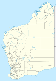
The Kimberley is the northernmost of the nine regions of Western Australia. It is bordered on the west by the Indian Ocean, on the north by the Timor Sea, on the south by the Great Sandy and Tanami deserts in the region of the Pilbara, and on the east by the Northern Territory.

Badgerys Creek, also known as Badgery's Creek, is a suburb of Sydney, in the state of New South Wales, Australia, located approximately 41 kilometres (25 mi) west of the Sydney central business district, in the local government areas of the City of Liverpool. It is part of the Greater Western Sydney region and is adjacent to Kemps Creek, Austral and the Blue Mountains.

Skippers Aviation is a small regional airline based out of Perth Airport that specialises in charter flights for companies with fly-in fly-out workers. They also operate flights for the mining industry in Western Australia, as well as some scheduled regular public transport (RPT) flights. Primarily serving the northern Goldfields, Skippers also has a secondary base in Broome in order to service the Kimberley region.

Jandakot Airport is an Australian general aviation airport located in Jandakot, Western Australia. Jandakot airport opened in 1963. From 1 July 1998, Jandakot Airport Holdings purchased a 50-year lease with a 49-year option to operate and maintain the airport including its conservation areas.

Albany Regional Airport is an airport serving Albany, Western Australia. It is located 6 nautical miles northwest of Albany just off Albany Highway and operated by the City of Albany.

Mungalalu Truscott Airbase or Truscott-Mungalalu Airport, which during World War II was known as Truscott Airfield is today a commercial airport in the remote Kimberley region of Western Australia.

Christmas Island International Airport is an airport located on Christmas Island, a territory of Australia in the Indian Ocean. The island is located 2,600 km (1,600 mi) northwest of the Western Australian city of Perth, 500 km (310 mi) south of the Indonesian capital, Jakarta, and 975 km (606 mi) east-northeast of the Cocos (Keeling) Islands.

Cocos (Keeling) Islands Airport is an airport serving the Cocos (Keeling) Islands, a territory of Australia located in the Indian Ocean. The airport is located on West Island, one of the South Keeling Islands and capital of the territory.
Network Aviation is an airline based at Perth Airport, operating regular scheduled and air charter services in support of "fly-in fly-out" mining operations throughout Western Australia. In partnership with subsidiary engineering provider Network Turbine Solutions, Network Aviation operates over 50 flights a week on behalf of mining companies to facilitate crew changes at remote sites.

The de Havilland DH.94 Moth Minor was a 1930s British two-seat tourer/trainer aircraft built by de Havilland at Hatfield Aerodrome, England. With the start of the second world war production of the Moth Minor was moved to de Havilland Australia at Bankstown Aerodrome, Australia.
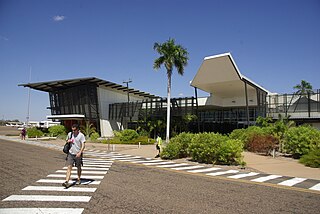
The East Kimberley Regional Airport, locally known as the Kununurra Airport, is an airport in Kununurra, Western Australia. The airport is 2 nautical miles west of the town. Heavy wet seasons often result in this area being cut off from essential outside services and deliveries. The airport is a crucial piece of infrastructure which enables people and goods to enter or leave from the region and especially supports tourism and economic development.

Paraburdoo Airport is an airport serving Paraburdoo, a town in the Pilbara region of Western Australia. The airport is located 5 nautical miles northeast of Paraburdoo. It also serves the town of Tom Price, with bus services completing the extra 71 km to Tom Price.
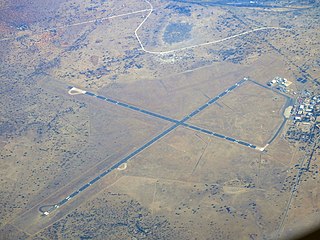
Halls Creek Airport is a regional airport in Western Australia's Kimberley region. It is located in Halls Creek, which is approximately 2,524 km (1,568 mi) from Perth, Western Australia.
Balgo Hill Airport is located 1 nautical mile south of Balgo, Western Australia.

Western Sydney Airport, formally the Western Sydney International Nancy-Bird Walton Airport is a new international airport under construction within the suburb of Badgerys Creek. The airport is planned to have 24-hour and curfew-free operations, and will supplement Kingsford Smith Airport, which has reached capacity due to a legislated curfew and flight caps. The first stage of construction on the new airport began on 24 September 2018, and the first stage is expected to be complete and open by December 2026. The site was officially designated by the Federal Government on 15 April 2014, after decades of debate on the location of another airport within Greater Sydney.
Graeme Rowley Aerodrome is located about 10 km northwest of Fortescue Metals Group's Christmas Creek mine in Western Australia.
Aviair Pty Ltd, previously known as Slingair Heliwork, is an airline and air charter company based in Kununurra, Western Australia. It operates air charter services and regular passenger services. Its main bases are Kununurra Airport, Broome International Airport and Karratha Airport.