Maylands is a suburb of Adelaide located within the City of Norwood Payneham St Peters, and bounded by the main roads Portrush Road and Magill Road.

Norwood is a suburb of Adelaide, about 4 km (2.5 mi) east of the Adelaide city centre. The suburb is in the City of Norwood Payneham & St Peters, whose predecessor was the oldest South Australian local government municipality.
The City of Burnside is a local government area in the South Australian city of Adelaide stretching from the Adelaide Parklands into the Adelaide foothills with an area of 2,753 hectares. It was founded in August 1856 as the District Council of Burnside, the name of a property of an early settler, and was classed as a city in 1943. The LGA is bounded by Adelaide, Adelaide Hills Council, Campbelltown, Mitcham, Norwood Payneham and St Peters and Unley.

Hackney is an inner-eastern suburb of Adelaide, South Australia, in the City of Norwood Payneham St Peters. It is adjacent to the Adelaide Park Lands, the Adelaide city centre and North Adelaide. The O-Bahn Busway passes along Hackney Road, part of the City Ring Route, which forms its western boundary. Its other boundaries are the River Torrens (north), the continuation of North Terrace through Kent Town (south), and a series of small streets and lanes to the east.
Heathpool is a residential suburb of Adelaide, Australia, east of the city, in the City of Norwood Payneham St Peters.
Kensington is a suburb of Adelaide, South Australia in the City of Norwood, Payneham & St Peters council area. Unlike the rest of the city, Kensington's streets are laid out diagonally. Second Creek runs through and under part of the suburb, which contains many heritage buildings as well as Norwood Swimming Centre and several schools.
Kent Town is an inner suburb of Adelaide, South Australia. It is located in the City of Norwood Payneham & St Peters local government area.
Marden is a suburb of Adelaide, South Australia in the City of Norwood Payneham St Peters. The suburb is bordered by the River Torrens to the north, O.G. Rd to the east, Payneham Rd to the south and Battams Rd to the west.
Payneham is an eastern suburb of Adelaide in the City of Norwood Payneham St Peters. It is part of a string of suburbs in Adelaide's east with a high proportion of Adelaide's Italian-Australian and French-Australian residents, many of whom can be traced back to the large-scale migration following World War II.
The City of Campbelltown is a local government area in the north eastern suburbs of Adelaide, South Australia about 6 kilometres from the Adelaide GPO. The city is bordered by the River Torrens and the City of Tea Tree Gully, the District of Adelaide Hills, the City of Burnside, the City of Norwood Payneham St Peters, and the City of Port Adelaide Enfield.

The history of the City of Burnside, a local government area in the metropolitan area of Adelaide, spans three centuries. Prior to European settlement Burnside was inhabited by the Kaurna people, who lived around the creeks of the River Torrens during the winter and in the Adelaide Hills during the summer.
The Norwood Town Hall is the council seat of the City of Norwood Payneham & St Peters, and the building includes a number of other venues. It is located at 175 The Parade in Norwood, an inner-eastern suburb of greater Adelaide, South Australia, five minutes east of the city centre. The current town hall building was completed in 1883, with the large concert hall added at the back between 1914 and 1918.
Gilberton is an inner northern suburb of Adelaide, South Australia on the northern bank of the River Torrens. It is a short distance from Adelaide's city centre. It is bounded by the river, Park Terrace, Stephen Terrace and Northcote Terrace. The suburb is largely residential with some large and ornate Victorian homes and approximately 2 kilometres (1 mi) of the Torrens Linear Park represent its southern boundary. The large homes in the suburb's northern section give it a historic character that is protected by government planning regulations.

The Hundred of Adelaide is a cadastral hundred in the city of Adelaide spanning all the inner suburbs south of River Torrens. It is one of the eleven hundreds of the County of Adelaide, and was one of the first hundreds to be proclaimed. Like the city it surrounds, the Hundred was named after Queen Adelaide, and was named by Governor Frederick Robe in 1846. It is 106 square miles (270 km2); close to but not exactly one hundred square miles as with most of the other hundreds. Its north boundary is the Torrens River and the Sturt River forms the south east boundary, with the hundred extending to the Adelaide foothills.

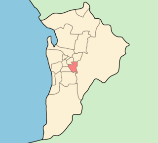
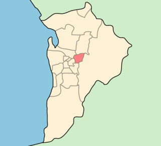
Dunstan is a single-member electoral district for the South Australian House of Assembly, covering the inner eastern suburbs of Beulah Park, College Park, Evandale, Firle, Hackney, Joslin, Kensington, Kensington Park, Kensington Gardens, Kent Town, Marden, Maylands, Norwood, Payneham, Payneham South, Royston Park, St Morris, St Peters, Stepney, and Trinity Gardens.
The District Council of East Torrens was a local government council of South Australia from 1853 to 1997.
The City of Kensington and Norwood, originally the Corporate Town of Kensington and Norwood, was a local government area in South Australia from 1853 to 1997, centred on the inner eastern Adelaide suburbs of Kensington and Norwood. In November 1997 it amalgamated with the City of Payneham and the Town of St Peters to form the City of Norwood Payneham & St Peters.
The City of Payneham, formerly the District Council of Stepney, was a local government area in South Australia from 1867 to 1997.
The Corporate Town of St Peters was a local government area in South Australia from 1883 to 1997.

The 2006 South Australian local elections were held in November 2006 to elect the councils of 66 of the 68 local government areas (LGAs) in South Australia. Many councils also held mayoral elections.