
Whitkirk is a suburb of east Leeds, England. It is situated between Cross Gates to the north, Austhorpe to the east, Killingbeck to the west, Colton to the south-east and Halton to the south-west. The Temple Newsam estate lies directly south of the area.

Temple Newsam is a Tudor-Jacobean house in Leeds, West Yorkshire, England, with grounds landscaped by Capability Brown.

Austhorpe is a civil parish and residential suburb of east Leeds, West Yorkshire, England. It is 5 miles (8.0 km) to the east of city centre and close to the A6120 dual carriageway and the M1 motorway.

Seacroft is an outer-city suburb/township consisting mainly of council estate housing covering an extensive area of east Leeds, West Yorkshire, England. It lies in the LS14 Leeds postcode area, around 4 miles (6.4 km) east of Leeds city centre.

Alwoodley is a suburb and civil parish of Leeds in West Yorkshire, England. It is 5 miles (8.0 km) north of central Leeds and is one of the most affluent areas of the county. Alwoodley lies in the LS17 postcode area which was reported to contain the most expensive housing area in Yorkshire and the Humber by The Times.

Halton is a district of east Leeds, West Yorkshire, England, situated between Cross Gates to the north, Halton Moor to the west, Colton to the east and Whitkirk to the South. Temple Newsam lies directly south of the estate.
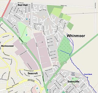
Whinmoor is a residential area of east Leeds, West Yorkshire, England.

East End Park is an inner city area of east Leeds, West Yorkshire, England. It is situated between Burmantofts to the north west, Harehills to the north east, Halton Moor to the east, Richmond Hill to the west and Cross Green to the south west. It blends into the Halton Moor/Osmondthorpe area and is 1 mile to the east of Leeds city centre in the LS9 Leeds postcode area.
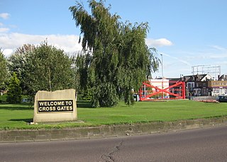
Cross Gates is a suburb in east Leeds, West Yorkshire, England.

Leeds East is a constituency represented in the House of Commons of the UK Parliament since 2015 by Richard Burgon of the Labour Party.
Swillington is a village and civil parish near Leeds, West Yorkshire, England, in the City of Leeds metropolitan borough. It is situated 5 miles (8 km) east from Leeds city centre, north of the River Aire, and is surrounded by streams including Fleakingley Beck. In 2001, Swillington had a population of about 3,530, reducing to 3,381 at the 2011 Census.

Richmond Hill is a district of Leeds, West Yorkshire, England. The district lies a mile to the east of the city centre between York Road, East End Park and Cross Green. The appropriate City of Leeds ward is Burmantofts and Richmond Hill.

Killingbeck is a district of east Leeds, West Yorkshire, England named after the Killingbeck family, historic local landowners, and is situated between Seacroft to the north, Cross Gates and Whitkirk to the east, Gipton to the west, Halton Moor to the south, Halton to the south-east and Osmondthorpe to the south-west.
Halton Moor is a district of east Leeds, West Yorkshire, England, about three miles east of Leeds city centre close to the A63. It is situated between Killingbeck to the north, Temple Newsam to the south, Osmondthorpe to the west and Halton and Colton to the east.

Temple Moor High School is a coeducational secondary school and sixth form located in Leeds, West Yorkshire, England. In recent years, it has received 'Science College' status. In 2017 an Ofsted inspection gave the school a Good rating.
Osmondthorpe a district of east Leeds in West Yorkshire, England is considered part of the Halton Moor district.
The Leeds Outer Ring Road is a main road that runs around most of the perimeter of the city of Leeds, West Yorkshire, England. The ring road is approximately 29 miles and consists of single and dual carriageways. The road is not a loop and so is not a true ring road, although it is designated as such.
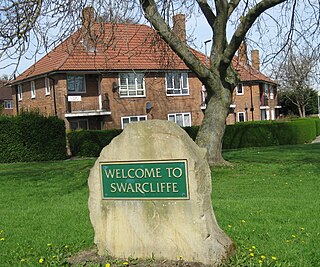
Swarcliffe, originally the Swarcliffe Estate, is a district of Leeds, West Yorkshire, England. It is 4.9 miles (8 km) east of Leeds city centre, and within the LS14 and LS15 Leeds postcode area. The district falls within the Cross Gates and Whinmoor ward of the Leeds Metropolitan Council.

Temple Newsam is an electoral ward of Leeds City Council in east Leeds, West Yorkshire, covering the outer city suburbs of Colton, Halton, Halton Moor and Whitkirk. Austhorpe is also shared with Cross Gates and Whinmoor ward, whilst the current civil parish boundaries of Austhorpe see its eastern half lie in the western tip of Garforth and Swillington ward.
Temple Newsam is a ward in the metropolitan borough of the City of Leeds, West Yorkshire, England. It contains 51 listed buildings that are recorded in the National Heritage List for England. Of these, two are listed at Grade I, the highest of the three grades, three are at Grade II*, the middle grade, and the others are at Grade II, the lowest grade. The ward is to the east of the centre of Leeds, it is largely residential, and contains the suburbs of Colton, Halton, Halton Moor and Whitkirk. The most important building in the ward is Temple Newsam House, which is listed, together with associated structures and buildings in the surrounding park. Most of the other listed buildings are houses, cottages and associated structures, farmhouses and farm buildings. The rest include churches and associated structures, a former windmill and mill buildings, two railway bridges, and a school.


