Coward, South Carolina

Last updated

Coward, South Carolina
SCMap-doton-Coward.PNG
Location of Coward in South Carolina
Coordinates: 33°58′32″N79°44′50″W / 33.97556°N 79.74722°W / 33.97556; -79.74722
Country United States
State South Carolina
County Florence
Area
[1]
  Total3.53 sq mi (9.15 km2)
  Land3.53 sq mi (9.15 km2)
  Water0.00 sq mi (0.00 km2)
Elevation
82 ft (25 m)
Population
 (2020) [2]
  Total748
  Density211.84/sq mi (81.79/km2)
Time zone UTC-5 (EST)
  Summer (DST) UTC-4 (EDT)
ZIP code
29530
Area code(s) 843, 854
FIPS code 45-17215 [3]
GNIS feature ID1247407 [4]
Website townofcoward.com

Coward is a town in Florence County, South Carolina, United States. The population was 752 at the 2010 census, [5] up from 650 in 2000. It is part of the Florence Metropolitan Statistical Area.

Contents

Geography

Coward is in south-central Florence County at 33°58′32″N79°44′50″W / 33.975560°N 79.747097°W / 33.975560; -79.747097 . [6] U.S. Route 52 runs through the center of town, leading north 16 miles (26 km) to Florence, the county seat, and south 7 miles (11 km) to Lake City. South Carolina Highway 541 leads west from Coward 12 miles (19 km) to Olanta.

According to the United States Census Bureau, the town of Coward has a total area of 3.5 square miles (9.1 km2), of which 0.637 acres (2,576 m2), or 0.03%, is water. [5] The town is in the watershed of the Lynches River, a tributary of the Pee Dee River.

Demographics

Historical population
CensusPop.Note
1970 466
1980 428−8.2%
1990 53224.3%
2000 65022.2%
2010 75215.7%
2020 748−0.5%
U.S. Decennial Census [7] [2]

As of the census [3] of 2000, there were 650 people, 246 households, and 178 families residing in the town. The population density was 189.9 inhabitants per square mile (73.3/km2). There were 263 housing units at an average density of 76.8 per square mile (29.7/km2). The racial makeup of the town was 84.15% White, 14.00% African American, 0.15% Asian, 0.62% from other races, and 1.08% from two or more races. Hispanic or Latino of any race were 1.38% of the population.

There were 246 households, out of which 32.9% had children under the age of 18 living with them, 56.1% were married couples living together, 12.2% had a female householder with no husband present, and 27.6% were non-families. 24.8% of all households were made up of individuals, and 8.1% had someone living alone who was 65 years of age or older. The average household size was 2.64 and the average family size was 3.17.

In the town, the population was spread out, with 26.2% under the age of 18, 9.7% from 18 to 24, 28.8% from 25 to 44, 25.5% from 45 to 64, and 9.8% who were 65 years of age or older. The median age was 35 years. For every 100 females, there were 98.8 males. For every 100 females age 18 and over, there were 94.3 males.

The median income for a household in the town was $28,182, and the median income for a family was $30,208. Males had a median income of $28,977 versus $17,039 for females. The per capita income for the town was $12,711. About 16.1% of families and 24.4% of the population were below the poverty line, including 37.2% of those under age of 18 and 43.2% of those aged 65 or over.

Related Research Articles

<span class="mw-page-title-main">Florence County, South Carolina</span> County in South Carolina, United States

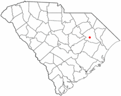
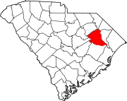
Florence County is a county located in the U.S. state of South Carolina. As of the 2020 census, its population was 137,059. Its county seat is Florence.

<span class="mw-page-title-main">Rogersville, Alabama</span> Town in Alabama, United States

Rogersville is a town in Lauderdale County, Alabama, United States. As of the 2018 census, the population of the town is 1,231, up from 1,199 in 2000.

<span class="mw-page-title-main">New Eagle, Pennsylvania</span> Borough in Pennsylvania, United States

New Eagle is a borough in Washington County, Pennsylvania, United States and is part of the Pittsburgh Metro Area. The population was 2,047 at the 2020 census.

<span class="mw-page-title-main">Hilda, South Carolina</span> Town in South Carolina, United States

Hilda is a town in Barnwell County, South Carolina, United States. The population was 447 at the 2010 census..

<span class="mw-page-title-main">Snelling, South Carolina</span> Town in South Carolina, United States

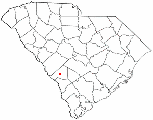
Snelling is a town in Barnwell County, South Carolina, United States. The population was 274 at the 2010 census.

<span class="mw-page-title-main">Bonneau, South Carolina</span> Town in South Carolina, United States

Bonneau is a town in Berkeley County, South Carolina, United States. The population was 487 at the 2010 census. It is part of the Charleston–North Charleston–Summerville Metropolitan Statistical Area.

<span class="mw-page-title-main">St. Stephen, South Carolina</span> Town in South Carolina, United States

St. Stephen is a town in Berkeley County, South Carolina, United States. The population was 1,697 at the 2010 census.

<span class="mw-page-title-main">Society Hill, South Carolina</span> Town in South Carolina, United States

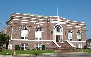
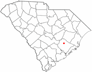
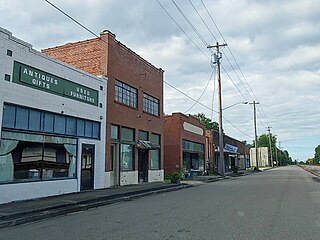
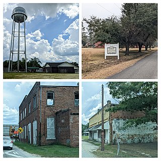
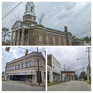
Society Hill is a town in Darlington County, South Carolina, United States alongside the Pee Dee River. It is the oldest community in Darlington County and one of the first towns founded in South Carolina. The town was once the intellectual center of the Pee Dee region. However, the town's fortunes declined in the 19th century after rivers became less important as means of transportation. It is part of the Florence Metropolitan Statistical Area.

<span class="mw-page-title-main">Lake View, South Carolina</span> Town in South Carolina, United States

Lake View is a town in Dillon County, South Carolina, United States. The population was 807 at the 2010 census.

<span class="mw-page-title-main">Olanta, South Carolina</span> Town in South Carolina, United States

Olanta is a town in Florence County, South Carolina, United States. The population was 563 at the 2010 census, down from 613 in 2000. It is part of the Florence Metropolitan Statistical Area.

<span class="mw-page-title-main">Pamplico, South Carolina</span> Town in South Carolina, United States

Pamplico is a town in southeastern Florence County, South Carolina, United States. The population was 1,226 at the 2010 census. It is part of the Florence Metropolitan Statistical Area.

<span class="mw-page-title-main">Quinby, South Carolina</span> Town in South Carolina, United States

Quinby is a town in Florence County, South Carolina, United States. The population was 932 at the 2010 census, up from 842 in 2000. It is part of the Florence Metropolitan Statistical Area.

<span class="mw-page-title-main">Scranton, South Carolina</span> Town in South Carolina, United States

Scranton is a town in Florence County, South Carolina, United States. The population was 932 at the 2010 census. It is part of the Florence Metropolitan Statistical Area.

<span class="mw-page-title-main">Timmonsville, South Carolina</span> Town in South Carolina, United States

Timmonsville is a town in Florence County, South Carolina, United States. The population was 2,320 at the 2010 census, an increase of five persons from 2000. It is part of the Florence Metropolitan Statistical Area.

<span class="mw-page-title-main">Clio, South Carolina</span> Town in South Carolina, United States

Clio is a town in Marlboro County, South Carolina, United States. The population was 726 at the 2010 census. Marlboro School of Discovery is a magnet school in Clio, South Carolina and is part of the Marlboro County School District.

<span class="mw-page-title-main">Arcadia Lakes, South Carolina</span> Town in South Carolina, United States

Arcadia Lakes is a town in Richland County, South Carolina, United States. The population was 861 at the 2010 census. It is part of the Columbia, South Carolina, Metropolitan Statistical Area.

<span class="mw-page-title-main">Jonesville, South Carolina</span> City in South Carolina, United States

Jonesville is a town in Union County, South Carolina, United States. The population was 911 at the 2010 United States Census.

<span class="mw-page-title-main">York, South Carolina</span> City in South Carolina, United States

York is a city in and county seat of York County, South Carolina, United States. The population was approximately 6,985 at the 2000 census and up to 7,736 at the 2010 census. York is located approximately 27 miles (43 km) southwest of Charlotte, North Carolina and 13 miles (21 km) west of Rock Hill, South Carolina.

<span class="mw-page-title-main">Florence, South Dakota</span> Town in South Dakota, United States

Florence is a town in northwestern Codington County, South Dakota, United States. It is part of the Watertown, South Dakota Micropolitan Statistical Area. The population was 337 at the 2020 census.

<span class="mw-page-title-main">Ridgeway, Virginia</span> Town in Virginia, United States

Ridgeway is a town in Henry County, Virginia, United States. The population was 742 at the 2010 census. It is part of the Martinsville Micropolitan Statistical Area. Martinsville Speedway, a NASCAR racetrack, is located between Ridgeway and the Martinsville city limits.

References

  1. "ArcGIS REST Services Directory". United States Census Bureau. Retrieved October 15, 2022.
  2. 1 2 "Census Population API". United States Census Bureau. Retrieved October 15, 2022.
  3. 1 2 "U.S. Census website". United States Census Bureau . Retrieved January 31, 2008.
  4. "US Board on Geographic Names". United States Geological Survey. October 25, 2007. Retrieved January 31, 2008.
  5. 1 2 "Geographic Identifiers: 2010 Demographic Profile Data (G001): Coward town, South Carolina". U.S. Census Bureau, American Factfinder. Retrieved August 15, 2016.[ dead link ]
  6. "US Gazetteer files: 2010, 2000, and 1990". United States Census Bureau. February 12, 2011. Retrieved April 23, 2011.
  7. "Census of Population and Housing". Census.gov. Retrieved June 4, 2015.