Olanta, South Carolina

Last updated

Olanta, South Carolina
Olanta SC.jpg
SCMap-doton-Olanta.PNG
Location of Olanta in South Carolina
Coordinates: 33°56′11″N79°55′55″W / 33.93639°N 79.93194°W / 33.93639; -79.93194
Country United States
State South Carolina
County Florence
Area
[1]
  Total1.00 sq mi (2.59 km2)
  Land0.99 sq mi (2.58 km2)
  Water0.00 sq mi (0.01 km2)
Elevation
112 ft (34 m)
Population
 (2020) [2]
  Total550
  Density552.76/sq mi (213.47/km2)
Time zone UTC-5 (EST)
  Summer (DST) UTC-4 (EDT)
ZIP code
29114
Area code(s) 843, 854
FIPS code 45-52540 [3]
GNIS feature ID1249947 [4]
Website www.olantasc.com

Olanta is a town in Florence County, South Carolina, United States. The population was 563 at the 2010 census, [5] down from 613 in 2000. It is part of the Florence Metropolitan Statistical Area.

Contents

Geography

Olanta is located in south Florence County at 33°56′11″N79°55′55″W / 33.93639°N 79.93194°W / 33.93639; -79.93194 (33.936256, -79.931944). [6] U.S. Route 301 passes through the town as Jones Road, leading northeast 24 miles (39 km) to Florence, the county seat, and southwest 23 miles (37 km) to Manning. South Carolina Highway 341 leads northwest from Olanta 13 miles (21 km) to Lynchburg and southeast 13 miles to Lake City. South Carolina Highway 541 leads east 12 miles (19 km) to Coward.

According to the United States Census Bureau, the town has a total area of 1.0 square mile (2.6 km2), of which 0.004 square miles (0.01 km2), or 0.44%, is water. [5]

Demographics

Historical population
CensusPop.Note
1910 230
1920 40977.8%
1930 4335.9%
1940 51518.9%
1950 58613.8%
1960 568−3.1%
1970 64012.7%
1980 6999.2%
1990 687−1.7%
2000 613−10.8%
2010 563−8.2%
2020 550−2.3%
U.S. Decennial Census [7] [2]

As of the census [3] of 2000, there were 613 people, 206 households, and 133 families residing in the town. The population density was 632.3 inhabitants per square mile (244.1/km2). There were 223 housing units at an average density of 230.0 per square mile (88.8/km2). The racial makeup of the town was 61.34% White, 37.52% African American, 0.98% from other races, and 0.16% from two or more races. Hispanic or Latino of any race were 1.14% of the population.

There were 206 households, out of which 28.2% had children under the age of 18 living with them, 40.8% were married couples living together, 20.4% had a female householder with no husband present, and 35.4% were non-families. 32.0% of all households were made up of individuals, and 14.1% had someone living alone who was 65 years of age or older. The average household size was 2.47 and the average family size was 3.15.

In the town, the population was spread out, with 21.4% under the age of 18, 7.3% from 18 to 24, 27.2% from 25 to 44, 22.7% from 45 to 64, and 21.4% who were 65 years of age or older. The median age was 41 years. For every 100 females, there were 95.2 males. For every 100 females age 18 and over, there were 105.1 males.

The median income for a household in the town was $27,813, and the median income for a family was $27,813. Males had a median income of $28,438 versus $17,361 for females. The per capita income for the town was $12,606. About 17.8% of families and 28.5% of the population were below the poverty line, including 54.0% of those under age 18 and 11.7% of those age 65 or over.

Education

Olanta has a public library, a branch of the Florence County Library System. [8]

Related Research Articles

<span class="mw-page-title-main">Florence County, South Carolina</span> County in South Carolina, United States

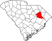
Florence County is a county located in the U.S. state of South Carolina. As of the 2020 census, its population was 137,059. Its county seat is Florence.

<span class="mw-page-title-main">Corsica, Pennsylvania</span> Borough in Pennsylvania, United States

Corsica is a borough in Jefferson County, Pennsylvania, United States. The population was 357 at the 2010 census. It was named for the island of Corsica, birthplace of Napoleon Bonaparte. The mayor of the borough is Dave Leadbetter.

<span class="mw-page-title-main">Elco, Pennsylvania</span> Borough in Pennsylvania, United States

Elco is a borough in Washington County, Pennsylvania, United States. The population was 263 at the 2020 census.

<span class="mw-page-title-main">Elko, South Carolina</span> Town in South Carolina, United States

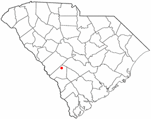
Elko is a town in Barnwell County, South Carolina, United States. According to the 2010 census the population was 193.

<span class="mw-page-title-main">Snelling, South Carolina</span> Town in South Carolina, United States

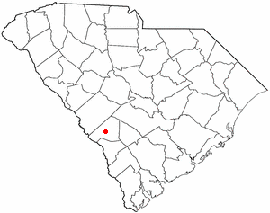
Snelling is a town in Barnwell County, South Carolina, United States. The population was 274 at the 2010 census.

<span class="mw-page-title-main">Bonneau, South Carolina</span> Town in South Carolina, United States

Bonneau is a town in Berkeley County, South Carolina, United States. The population was 487 at the 2010 census. It is part of the Charleston–North Charleston–Summerville Metropolitan Statistical Area.

<span class="mw-page-title-main">Moncks Corner, South Carolina</span> Town in South Carolina, United States

Moncks Corner is a town in and the county seat of Berkeley County, South Carolina, United States. The population was 7,885 at the 2010 census. As defined by the U.S. Census Bureau, Moncks Corner is included within the Charleston-North Charleston, SC Metropolitan Statistical Area.

<span class="mw-page-title-main">Turbeville, South Carolina</span> Town in South Carolina, United States

Turbeville is a town in Clarendon County, South Carolina, United States. The population was 766 at the 2010 census, up from 602 in 2000.

<span class="mw-page-title-main">Coward, South Carolina</span> Town in South Carolina, United States

Coward is a town in Florence County, South Carolina, United States. The population was 752 at the 2010 census, up from 650 in 2000. It is part of the Florence Metropolitan Statistical Area.

<span class="mw-page-title-main">Johnsonville, South Carolina</span> City in South Carolina, United States

Johnsonville is a city in Florence County, South Carolina, United States. The population was 1,480 at the 2010 census. It is part of the Florence Metropolitan Statistical Area.

<span class="mw-page-title-main">Lake City, South Carolina</span> City in South Carolina, United States

Lake City is a city in Florence County, South Carolina, United States. The population was 6,675 at the 2010 census. Located in central South Carolina, it is south of Florence and included as part of the Florence Metropolitan Statistical Area.

<span class="mw-page-title-main">Pamplico, South Carolina</span> Town in South Carolina, United States

Pamplico is a town in southeastern Florence County, South Carolina, United States. The population was 1,226 at the 2010 census. It is part of the Florence Metropolitan Statistical Area.

<span class="mw-page-title-main">Quinby, South Carolina</span> Town in South Carolina, United States

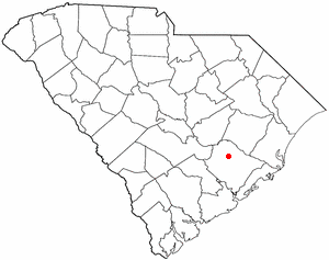
Quinby is a town in Florence County, South Carolina, United States. The population was 932 at the 2010 census, up from 842 in 2000. It is part of the Florence Metropolitan Statistical Area.

<span class="mw-page-title-main">Scranton, South Carolina</span> Town in South Carolina, United States

Scranton is a town in Florence County, South Carolina, United States. The population was 932 at the 2010 census. It is part of the Florence Metropolitan Statistical Area.

<span class="mw-page-title-main">Red Hill, South Carolina</span> Census-designated place in South Carolina, United States

Red Hill is a census-designated place (CDP) in Horry County, South Carolina, United States. The population was 13,223 at the 2010 census, up from 10,509 at the 2000 census.

<span class="mw-page-title-main">Red Bank, South Carolina</span> Census-designated place in South Carolina, United States

Red Bank is an unincorporated community and census-designated place (CDP) in Lexington County, South Carolina, United States. The population was 9,617 at the 2010 census, up from 8,811 at the 2000 census. It is part of the Columbia, South Carolina Metropolitan Statistical Area.

<span class="mw-page-title-main">Arcadia Lakes, South Carolina</span> Town in South Carolina, United States

Arcadia Lakes is a town in Richland County, South Carolina, United States. The population was 861 at the 2010 census. It is part of the Columbia, South Carolina, Metropolitan Statistical Area.

<span class="mw-page-title-main">Lane, South Carolina</span> Town in South Carolina, United States

Lane is a town in Williamsburg County, South Carolina, United States. The population was 480 at the 2020 census.

<span class="mw-page-title-main">Florence, South Dakota</span> Town in South Dakota, United States

Florence is a town in northwestern Codington County, South Dakota, United States. It is part of the Watertown, South Dakota Micropolitan Statistical Area. The population was 337 at the 2020 census.

<span class="mw-page-title-main">Alberta, Virginia</span> Town in Virginia, United States

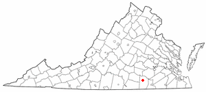
Alberta is a town in Brunswick County, Virginia, United States. The population was 302 at the 2020 census. It is home to the Christanna Campus of Southside Virginia Community College.

References

  1. "ArcGIS REST Services Directory". United States Census Bureau. Retrieved October 15, 2022.
  2. 1 2 "Census Population API". United States Census Bureau. Retrieved October 15, 2022.
  3. 1 2 "U.S. Census website". United States Census Bureau . Retrieved January 31, 2008.
  4. "US Board on Geographic Names". United States Geological Survey. October 25, 2007. Retrieved January 31, 2008.
  5. 1 2 "Geographic Identifiers: 2010 Demographic Profile Data (G001): Olanta town, South Carolina". U.S. Census Bureau, American Factfinder. Retrieved August 1, 2016.[ dead link ]
  6. "US Gazetteer files: 2010, 2000, and 1990". United States Census Bureau. February 12, 2011. Retrieved April 23, 2011.
  7. "Census of Population and Housing". Census.gov. Retrieved June 4, 2015.
  8. "South Carolina libraries and archives". SCIWAY. Retrieved June 8, 2019.