Quinby, South Carolina

Last updated

Quinby, South Carolina
SCMap-doton-Quinby.PNG
Location of Quinby in South Carolina
Coordinates: 34°13′42″N79°43′57″W / 34.22833°N 79.73250°W / 34.22833; -79.73250
Country United States
State South Carolina
County Florence
Area
[1]
  Total1.31 sq mi (3.38 km2)
  Land1.31 sq mi (3.38 km2)
  Water0.00 sq mi (0.00 km2)
Elevation
118 ft (36 m)
Population
 (2020) [2]
  Total915
  Density700.08/sq mi (270.33/km2)
Time zone UTC-5 (EST)
  Summer (DST) UTC-4 (EDT)
ZIP code
29506
Area code(s) 843, 854
FIPS code 45-58795 [3]
GNIS feature ID1253496 [4]
Website www.townofquinby.com

Quinby is a town in Florence County, South Carolina, United States. The population was 932 at the 2010 census, [5] up from 842 in 2000. It is part of the Florence Metropolitan Statistical Area.

Contents

Geography

Quinby is located in northern Florence County at 34°13′42″N79°43′57″W / 34.22833°N 79.73250°W / 34.22833; -79.73250 (34.228445, -79.732460). [6] It is bordered on the south and west by the city of Florence, the county seat. The town limits extend north to Black Creek, a tributary of the Pee Dee River. Interstate 95 passes north and west of the town, with the closest access from Exit 169, 3 miles (5 km) to the north.

According to the United States Census Bureau, the town has a total area of 1.4 square miles (3.5 km2), all land. [5]

Demographics

Historical population
CensusPop.Note
1970 788
1980 95220.8%
1990 865−9.1%
2000 842−2.7%
2010 93210.7%
2020 915−1.8%
U.S. Decennial Census [7] [2]

As of the census [3] of 2000, there were 842 people, 331 households, and 254 families residing in the town. The population density was 755.6 inhabitants per square mile (291.7/km2). There were 351 housing units at an average density of 315.0 per square mile (121.6/km2). The racial makeup of the town was 42.87% White, 56.18% African American, 0.12% Native American, and 0.83% from two or more races. Hispanic or Latino of any race were 0.36% of the population.

There were 331 households, out of which 30.5% had children under the age of 18 living with them, 63.1% were married couples living together, 12.7% had a female householder with no husband present, and 23.0% were non-families. 22.1% of all households were made up of individuals, and 8.8% had someone living alone who was 65 years of age or older. The average household size was 2.54 and the average family size was 2.97.

In the town, the population was spread out, with 23.4% under the age of 18, 5.5% from 18 to 24, 24.3% from 25 to 44, 29.7% from 45 to 64, and 17.1% who were 65 years of age or older. The median age was 43 years. For every 100 females, there were 92.2 males. For every 100 females age 18 and over, there were 88.0 males.

The median income for a household in the town was $52,639, and the median income for a family was $55,556. Males had a median income of $33,125 versus $25,417 for females. The per capita income for the town was $22,804. About 8.1% of families and 7.8% of the population were below the poverty line, including 13.5% of those under age 18 and 1.8% of those age 65 or over.

Related Research Articles

<span class="mw-page-title-main">Opp, Alabama</span> City in Alabama, United States

Opp is a city in Covington County, Alabama, United States. At the 2020 census, the population was 6,771. Opp is named after Henry Opp, a lawyer for the Louisville and Nashville Railroad.

<span class="mw-page-title-main">Rogersville, Alabama</span> Town in Alabama, United States

Rogersville is a town in Lauderdale County, Alabama, United States. As of the 2018 census, the population of the town is 1,231, up from 1,199 in 2000.

<span class="mw-page-title-main">Ripley, Mississippi</span> City in Mississippi, United States

Ripley is a city in Tippah County, Mississippi, United States. The population was 5,395 at the 2010 census. It is the county seat of Tippah County.

<span class="mw-page-title-main">Meadowlands, Minnesota</span> City in Minnesota, United States

Meadowlands is a city in Saint Louis County, Minnesota, United States. The population was 134 at the 2010 census.

<span class="mw-page-title-main">Charlotte, New York</span> Town in New York, United States

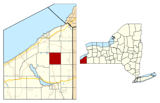
Charlotte is a town in Chautauqua County, New York, United States. As of the 2020 census, the town population was 1,521. Charlotte is centrally located in the county, north of Jamestown and south of Dunkirk.

<span class="mw-page-title-main">Hannaford, North Dakota</span> City in North Dakota, United States

Hannaford is a city in Griggs County, North Dakota, United States. The population was 126 at the 2020 census. Hannaford was founded in 1883.

<span class="mw-page-title-main">Velva, North Dakota</span> City in North Dakota, United States

Velva is a city in McHenry County, North Dakota, United States. Part of the Minot Micropolitan Statistical Area, it was founded in 1897 and the population was 1,086 at the 2020 census. Southeast of Minot, Velva is at the southernmost point of the Souris River.

<span class="mw-page-title-main">Guys Mills, Pennsylvania</span> Census-designated place in Pennsylvania, United States

Guys Mills is a census-designated place in Crawford County, Pennsylvania, United States. The population was 124 at the 2010 census.

Jacksonville is a census-designated place (CDP) in Indiana County, Pennsylvania, United States. The population was 637 at the 2010 census. It was formerly an independent borough, until January 1, 1993 when it was returned to Black Lick Township, Pennsylvania.

<span class="mw-page-title-main">St. Clair Township, Pennsylvania</span> Township in Pennsylvania, United States

St. Clair Township is a township in Westmoreland County, Pennsylvania, United States. The population was 1,339 at the 2020 census. It is also one of three communities within the county to utilise the 814 area code, alongside New Florence and Seward.

<span class="mw-page-title-main">Coward, South Carolina</span> Town in South Carolina, United States

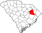
Coward is a town in Florence County, South Carolina, United States. The population was 752 at the 2010 census, up from 650 in 2000. It is part of the Florence Metropolitan Statistical Area.

<span class="mw-page-title-main">Olanta, South Carolina</span> Town in South Carolina, United States

Olanta is a town in Florence County, South Carolina, United States. The population was 563 at the 2010 census, down from 613 in 2000. It is part of the Florence Metropolitan Statistical Area.

<span class="mw-page-title-main">Pamplico, South Carolina</span> Town in South Carolina, United States

Pamplico is a town in southeastern Florence County, South Carolina, United States. The population was 1,226 at the 2010 census. It is part of the Florence Metropolitan Statistical Area.

<span class="mw-page-title-main">Timmonsville, South Carolina</span> Town in South Carolina, United States

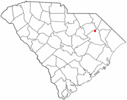
Timmonsville is a town in Florence County, South Carolina, United States. The population was 2,320 at the 2010 census, an increase of five persons from 2000. It is part of the Florence Metropolitan Statistical Area.

<span class="mw-page-title-main">Sellers, South Carolina</span> Town in South Carolina, United States

Sellers is a small town in Marion County, South Carolina, United States. The population was 219 at the 2000 census.

<span class="mw-page-title-main">Florence, South Dakota</span> Town in South Dakota, United States

Florence is a town in northwestern Codington County, South Dakota, United States. It is part of the Watertown, South Dakota Micropolitan Statistical Area. The population was 337 at the 2020 census.

<span class="mw-page-title-main">Altamont, Tennessee</span> Town in Tennessee, United States

Altamont is a town in Grundy County, Tennessee, United States. The population was 1,117 at the 2020 census. It is the county seat of Grundy County.

<span class="mw-page-title-main">Village of Maine, Wisconsin</span> Village in Wisconsin, United States

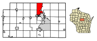
Maine is an incorporated village in Marathon County, Wisconsin, United States. It is part of the Wausau, Wisconsin Metropolitan Statistical Area. The population was 2,337 at the 2010 census. The unincorporated communities of Mount View and Taegesville are located partially in the town.

<span class="mw-page-title-main">Blue Mounds (town), Wisconsin</span> Town in Wisconsin, United States

Blue Mounds is a town in Dane County, Wisconsin, United States. The population was 899 at the 2020 census. The Village of Blue Mounds is located within the town.

Wittenberg is a town in Shawano County, Wisconsin, United States. As of the 2000 census, the town had a total population of 894. The Village of Wittenberg is located within the town. The unincorporated community of Whitcomb is also located within the town.

References

  1. "ArcGIS REST Services Directory". United States Census Bureau. Retrieved October 15, 2022.
  2. 1 2 "Census Population API". United States Census Bureau. Retrieved October 15, 2022.
  3. 1 2 "U.S. Census website". United States Census Bureau . Retrieved January 31, 2008.
  4. "US Board on Geographic Names". United States Geological Survey. October 25, 2007. Retrieved January 31, 2008.
  5. 1 2 "Geographic Identifiers: 2010 Demographic Profile Data (G001): Quinby town, South Carolina". U.S. Census Bureau, American Factfinder. Retrieved August 16, 2016.[ dead link ]
  6. "US Gazetteer files: 2010, 2000, and 1990". United States Census Bureau. February 12, 2011. Retrieved April 23, 2011.
  7. "Census of Population and Housing". Census.gov. Retrieved June 4, 2015.