Daresbury

Last updated

Daresbury
The Ring 'O' Bells - geograph.org.uk - 1725651.jpg
'The Ring 'O' Bells' public house, Daresbury
Cheshire UK location map.svg
Red pog.svg
Daresbury
Location within Cheshire
Population246 (2011 census) [1]
OS grid reference SJ5881
Unitary authority
Ceremonial county
Region
Country England
Sovereign state United Kingdom
Post town Warrington
Postcode district WA4
Dialling code 01925
Police Cheshire
Fire Cheshire
Ambulance North West
UK Parliament
List of places
UK
England
Cheshire
53°20′25″N2°38′00″W / 53.3402°N 2.6332°W / 53.3402; -2.6332

Daresbury is a village and civil parish in the Borough of Halton, Cheshire, England. At the 2011 census, it had a population of 246. [1]

Contents

History

Lewis Carroll, 1857 LewisCarrollSelfPhoto.jpg
Lewis Carroll, 1857

The name means "Deor's fortification", derived from an Old English personal name and the word burh (a fortified place). [2]

The population was recorded over time at 134 in the census of 1801, 157 in 1851, 153 in 1901, 235 in 1951 and reaching 216 by 2001. [3]

Opened in 1850 on the Birkenhead Railway, the area was served by Daresbury railway station in the nearby village of Moore. The station closed to passengers in 1952 and to goods in 1965, although the line through the station site remains in use. [4]

Daresbury was the birthplace of Alice's Adventures in Wonderland author Lewis Carroll, in All Saints' Vicarage. The village has a Lewis Carroll Visitor Centre [5] and in the parish church of All Saints, a Lewis Carroll window, which includes an image of the Cheshire Cat. [6]

Landmarks

Built in 1759, Daresbury Hall is a former Georgian country house which has been used as a private dwelling, military hospital and residential home. A designated Grade II* listed building since 1952, [7] it is on the Heritage at Risk Register due to being in very poor condition. A major fire in June 2016 destroyed much of the building, which has since been secured with scaffold and mothballed in a roofless condition. [8]

Governance

Daresbury was a township and chapelry in Runcorn parish of Bucklow Hundred, which became a civil parish in 1866. The village was administered as part of Runcorn Rural Sanitary District from 1875, then from 1894 Runcorn Rural District. Local government reorganisation on 1 April 1974 transferred the area to the Borough of Halton. [3]

Daresbury is also an electoral ward. However, the boundary of the ward is different from (and larger than) the parish boundary, and includes the parishes of Moore, Sandymoor and Preston Brook. The total ward population in 2011 was 5,401. [9] Daresbury is represented nationally by the Weaver Vale parliamentary constituency.

Economy

The Tower at Daresbury Laboratory Daresbury Laboratory tower.jpg
The Tower at Daresbury Laboratory

Near the village is the Science and Technology Facilities Council's Sci-Tech Daresbury science and innovation campus, which includes the Daresbury Laboratory and the Cockcroft Institute. The Synchrotron Radiation Source (SRS) facility at Daresbury Laboratory was in operation between 1981 and 2008.

Daresbury Park is to the south west of the village, at junction 11 of the M56 motorway. The 225 acres (91 ha) site provides office and warehouse space for several businesses and includes the Daresbury Park Hotel. [10]

Transport

The village of Daresbury lies to the east of the realigned A56 road. The B5356 Daresbury Lane heads eastwards from the village towards Hatton and Stretton, while the A558 Daresbury Expressway heads westwards towards Runcorn and crosses the Bridgewater Canal.

Community and culture

In 2006, the annual Creamfields dance festival was held in Daresbury after relocating from the disused Liverpool airport site it had occupied for the six previous years. This saw 40,000 revellers partying from 3pm-6am to a line-up that included live performances from The Prodigy and Zutons, as well as DJ sets from the likes of Sasha, Paul Oakenfold, 2 Many DJ's, Green Velvet and DJ Shadow. As of 2019, the festival has been an annual event at the site.

See also

Related Research Articles

<span class="mw-page-title-main">Runcorn</span> Town in England

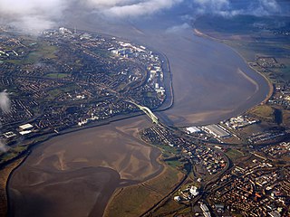
Runcorn is an industrial town and cargo port in the Borough of Halton in Cheshire, England. Its population in 2011 was 61,789. Runcorn is on the southern bank of the River Mersey, where the estuary narrows to form the Runcorn Gap.

<span class="mw-page-title-main">Borough of Halton</span> Borough and Unitary authority in England

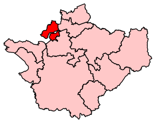
Halton is a unitary authority district with borough status in Cheshire, North West England. It was created in 1974 as a district of the non-metropolitan county of Cheshire, and became a unitary authority area on 1 April 1998 under Halton Borough Council. Since 2014, it has been a member of the Liverpool City Region Combined Authority. The borough consists of the towns of Runcorn and Widnes and the civil parishes of Daresbury, Hale, Halebank, Moore, Preston Brook, and Sandymoor. The district borders Merseyside, the Borough of Warrington and Cheshire West and Chester.

<span class="mw-page-title-main">Civil parishes in Cheshire</span>

A civil parish is a country subdivision, forming the lowest unit of local government in England. There are 333 civil parishes in the ceremonial county of Cheshire, most of the county being parished. Cheshire East unitary authority is entirely parished. At the 2001 census, there were 565,259 people living in 332 parishes, accounting for 57.5 per cent of the county's population.

<span class="mw-page-title-main">Halton (UK Parliament constituency)</span> Parliamentary constituency in the United Kingdom, 1983 onwards

<span class="mw-page-title-main">Weaver Vale (UK Parliament constituency)</span> Parliamentary constituency in the United Kingdom, 1997 onwards

<span class="mw-page-title-main">Alvanley</span> Human settlement in England

Alvanley is a small rural village and civil parish near Helsby, in the unitary authority of Cheshire West and Chester and the ceremonial county of Cheshire, England. The village is on the B5393 road and near junction 14 of the M56 motorway. According to the 2011 census the civil parish had a population of 472.

<span class="mw-page-title-main">Ince, Cheshire</span> Human settlement in England

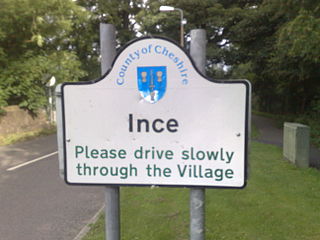
Ince is a village and civil parish in the unitary authority of Cheshire West and Chester and the ceremonial county of Cheshire, England. It is situated immediately to the east of the Stanlow Oil Refinery. It shares Ince & Elton railway station with the village of Elton, which it runs into.

<span class="mw-page-title-main">Runcorn Rural District</span>

<span class="mw-page-title-main">Bulkeley</span> Human settlement in England

Bulkeley is a village and civil parish in the unitary authority of Cheshire East and the ceremonial county of Cheshire, England. The village is on the A534 road, 9 miles (14 km) west of Nantwich. In the 2011 census it had a population of 239.

<span class="mw-page-title-main">Preston Brook</span> Human settlement in England

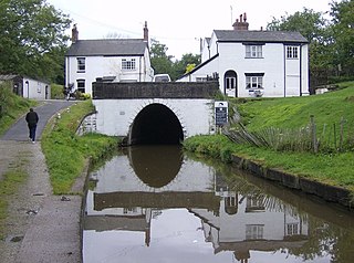
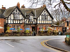
Preston Brook is a village and civil parish in the borough of Halton, a unitary authority in the ceremonial county of Cheshire in North West England. It is located to the south-east of Runcorn and south-west of Warrington, adjacent to the M56 motorway. The parish includes the village of Preston on the Hill.

<span class="mw-page-title-main">Croft-on-Tees</span> Village and civil parish in North Yorkshire, England

Croft-on-Tees is a village and civil parish in the Richmondshire district of North Yorkshire, England. It has also been known as Croft Spa, and from which the former Croft Spa railway station took its name. It lies 11 miles (18 km) north-north west of the county town of Northallerton.

<span class="mw-page-title-main">Moore, Cheshire</span> Human settlement in England

Moore is a village and civil parish in the Borough of Halton, Cheshire, England, located midway between Runcorn and Warrington. It has a population of 807.

<span class="mw-page-title-main">All Saints' Church, Daresbury</span> Church in Cheshire, England

All Saints' Church is in the village of Daresbury, Cheshire, England. It is known for its association with Lewis Carroll who is commemorated in its stained glass windows depicting characters from Alice's Adventures in Wonderland. It is recorded in the National Heritage List for England as a designated Grade II* listed building. The church is an active Church of England parish church in the diocese of Chester, the archdeaconry of Chester and the deanery of Great Budworth. The author Lewis Carroll was born in All Saints' Vicarage in 1832 when his father, Charles Dodgson, was perpetual curate at the church. This was commemorated in March 2012 when the Lewis Carroll Centre, attached to the church, was opened.

Keckwick is an area in the Borough of Halton in Cheshire. Although there is no village as such, numerous toponyms attest to a particular identity in the area which straddles the West Coast Main Line between the village of Daresbury and the new town of Runcorn.

<span class="mw-page-title-main">Preston on the Hill</span> Human settlement in England

Preston on the Hill is a village in the civil parish of Preston Brook and the unitary authority of Halton, in Cheshire, England. It is between the villages of Daresbury 1.5 miles (2.4 km) to the north and Dutton 1.1 miles (1.8 km) to the south. The village comprises the hamlets of Windmill Lane, Waterfront, Cotton's Bridge, Tunnel End North, Tunnel Top and Barker's Hollow as well as several farms including White House, Little Manor, New Manor, Windmill Farm and Humble Bee House.

<span class="mw-page-title-main">Halton Borough Council</span>

Halton Borough Council is the local authority for the Borough of Halton, incorporating the towns of Runcorn and Widnes and the parishes of Daresbury, Hale, Moore and Preston Brook. It is a constituent council of Liverpool City Region Combined Authority.

<span class="mw-page-title-main">Sandymoor</span> Human settlement in England

Sandymoor is a civil parish in Runcorn, Halton, Cheshire, England, with a population of approximately 3,663. The majority of housing in Sandymoor was built post-1990 and the parish was formed in 2008 by the Halton Order 2008. Sandymoor lies approximately 3 miles east of Runcorn town centre, 4 miles south-west from Warrington town centre and 2 miles north of the M56 motorway.

<span class="mw-page-title-main">Listed buildings in Runcorn (rural area)</span>

Runcorn is an industrial town in the borough of Halton, Cheshire, England. This list contains the 27 buildings that are recorded in the National Heritage List for England as designated listed buildings in the part of the borough lying to the south of the River Mersey outside the urban area of Runcorn. The area covered includes the villages of Clifton, Daresbury, Preston Brook, Preston on the Hill, and Moore. Three of the buildings in the area are classified as Grade II*, and the others are at Grade II; there are no buildings in Grade I. In the United Kingdom, the term listed building refers to a building or other structure officially designated as being of special architectural, historical, or cultural significance. These buildings are in three grades: Grade I consists of buildings of outstanding architectural or historical interest; Grade II* includes particularly significant buildings of more than local interest; Grade II consists of buildings of special architectural or historical interest. Buildings in England are listed by the Secretary of State for Culture, Media and Sport on recommendations provided by English Heritage, which also determines the grading.

<span class="mw-page-title-main">Daresbury Hall</span>

Daresbury Hall is a former Georgian country house in the village of Daresbury, Cheshire, England. It was built in 1759 for George Heron. The house is recorded in the National Heritage List for England as a designated Grade II* listed building. The mansion was badly damaged by fire in 2016.

There are over 9,000 Grade I listed buildings and 20,000 Grade II* listed buildings in England. This page is a list of these buildings in the borough of Halton in Cheshire.

References

  1. 1 2 UK Census (2011). "Local Area Report – Daresbury Parish (E04000313)". Nomis. Office for National Statistics . Retrieved 26 May 2020.
  2. "Key to English Place Names: Daresbury". University of Nottingham. Archived from the original on 14 May 2021. Retrieved 26 June 2021.
  3. 1 2 "Daresbury". GENUKI UK & Ireland Genealogy. Archived from the original on 26 June 2021. Retrieved 26 June 2021.
  4. "Station Name: Daresbury". Disused Stations. Archived from the original on 18 May 2021. Retrieved 26 June 2021.
  5. "Home". Lewis Carroll Centre & All Saints Daresbury PCC. Archived from the original on 26 June 2021. Retrieved 26 June 2021.
  6. Chester Diocesan News, February 2011
  7. Historic England. "Daresbury Hall (1330337)". National Heritage List for England . Retrieved 26 June 2021.
  8. "Heritage at Risk Register: Daresbury Hall (46467)". Historic England. Archived from the original on 26 June 2021. Retrieved 26 June 2021.
  9. UK Census (2011). "Local Area Report – Daresbury Ward (E05001582)". Nomis. Office for National Statistics . Retrieved 26 June 2021.
  10. "Welcome to Daresbury Park". Archived from the original on 26 June 2021. Retrieved 26 June 2021.