Weaver Vale (UK Parliament constituency)

Last updated

Weaver Vale
County constituency
for the House of Commons
WeaverVale2007Constituency.svg
Boundary of Weaver Vale in Cheshire
EnglandCheshire.svg
Location of Cheshire within England
County Cheshire
Electorate 70,129 (2018) [1]
Major settlements Northwich, Runcorn and Frodsham
Current constituency
Created 1997
Member of Parliament Mike Amesbury (Labour)
SeatsOne
Created from Eddisbury, Tatton, Halton, and Warrington South

Weaver Vale is a constituency [n 1] in Cheshire represented in the House of Commons of the UK Parliament since 2017 by Mike Amesbury, a member of the Labour Party. [n 2]

Contents

The seat is due to be abolished for the next general election. [2]

Constituency profile

The constituency takes its name from the River Weaver, which flows through the area, and much of the area was part of the former district of Vale Royal. It covers the northern part of the Cheshire West and Chester unitary authority in Cheshire, including the towns of Northwich and Frodsham and the villages of Helsby and Weaverham. It also includes part of the Borough of Halton, covering the eastern half of Runcorn.

The area has economic sectors as diverse as plastics and chemicals to construction. Other areas include telecommunications/bank communication centres, with in addition, a large national bakery and a supermarket distribution centre. Salt used to comprise a major mining industry of the area, much more of which is extracted today from large reserves in Northern Ireland. Workless claimants who were registered jobseekers were in November 2012 slightly higher than the national average of 3.8%, at 4.1% of the population based on a statistical compilation by The Guardian . This was, however, lower than the regional average of 4.4%. [3] Northwich and the wards from Halton are inclined to vote Labour, whereas Frodsham, Helsby and the smaller rural villages are more Conservative.

Creation

Weaver Vale was created for the 1997 general election from parts of Eddisbury, Tatton, Halton, and Warrington South, when the number of constituencies in Cheshire was increased from 10 to 11.

Boundaries

Weaver Vale (UK Parliament constituency)
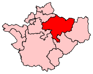
Map of current boundaries

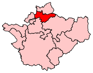
1997–2010: The District of Vale Royal wards of Castle, Church, Forest, Frodsham East, Frodsham North West, Frodsham South, Gorst Wood, Hartford, Helsby Central, Helsby North, Helsby South and Alvanley Ward, Kingsley, Milton, Northwich, Weaver, Winnington, Witton North, and Witton South, and the Borough of Halton wards of Brookfields, Castlefields, Clough, Daresbury, Murdishaw, and Norton. [4]

Norton and Daresbury were transferred from Warrington South, with other parts of Halton coming from the constituency thereof. Frodsham, Helsby and Weaverham were transferred from Eddisbury and Northwich had previously been part of Tatton.

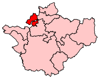
2010–2019: The Parliamentary Constituencies (England) Order 2007 defined the boundaries as:

The Borough of Halton wards of Beechwood, Daresbury, Halton Lea, Norton North, Norton South, and Windmill Hill, and the Borough of Vale Royal wards of Forest, Frodsham North, Frodsham South, Hartford & Whitegate, Helsby, Kingsley, Leftwich & Kingsmead, Milton Weaver, Northwich Castle, Northwich Winnington, Northwich Witton, and Weaverham. [5]

Halton Borough ward of Castlefields transferred to Halton constituency. Other minor changes due to revision of ward boundaries.

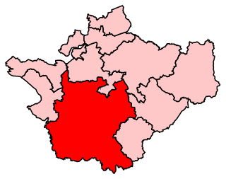
However, before the new boundaries came into force for the 2010 election, the districts making up the county of Cheshire were abolished on 1 April 2009, being replaced by four unitary authorities. Consequently, the constituency's boundaries became:

The Cheshire West and Chester wards of Davenham & Moulton (part), Frodsham, Gowy (part), Hartford & Greenbank, Helsby, Kingsley, Weaver & Cuddington (part), Winsford Over & Verdin (part), Winnington & Castle, and Witton & Rudheath (part), and the Borough of Halton wards of Beechwood, Daresbury, Halton Lea, Norton North, Norton South, and Windmill Hill.

2019–present: Following a further local government ward boundary review in 2019, the boundaries are currently:

The Cheshire West and Chester wards of Davenham, Moulton & Kingsmead (part), Frodsham, Hartford & Greenbank, Helsby, Marbury (part), Northwich Leftwich, Northwich Winnington & Castle, Northwich Witton, Rudheath (part), Sandstone (part), Weaver & Cuddington (part), and Winsford Over & Verdin (part), and the Borough of Halton wards of Beechwood, Daresbury, Halton Lea, Norton North, Norton South, and Windmill Hill. [6]

Proposed abolition

Further to the completion of the 2023 Periodic Review of Westminster constituencies, the seat will be abolished for the next general election, with its contents distributed to three new constituencies: [2]

Political history

From the 1997 general election, the new seat was held by the Labour Party's Mike Hall, who had first entered Parliament in 1992 for Warrington South. Labour held the seat relatively easily in the succeeding two general elections. In February 2010 Hall announced that he was standing down at the 2010 election due to health reasons. [7] Graham Evans (Conservative) gained the seat at the 2010 election on a swing of 8.15% with minor boundary changes mentioned likely affecting this swing.

The present MP, Mike Amesbury, regained the seat for Labour at the 2017 general election and was returned with a reduced majority in 2019.

Weaver Vale was one of seven seats won (held or gained) by a Labour candidate in 2017 from a total of 11 covering its county. Amesbury's 2017 win was one of 30 net gains of the Labour Party, three of which came from the county Cheshire.

The seat has been considered relative to others a marginal seat since 2005 as its winner's majority has not exceeded 7.8% of the vote since the 17.4% majority won in 2005 and the seat has changed hands twice since that year.

Members of Parliament

ElectionMember [8] Party
1997 Mike Hall Labour
2010 Graham Evans Conservative
2017 Mike Amesbury Labour

Elections

Elections in the 2010s

General election 2019: Weaver Vale [9]
PartyCandidateVotes%±%
Labour Mike Amesbury 22,772 44.9 ―6.6
Conservative Adam Wordsworth22,21043.8+0.1
Liberal Democrats Daniela Parker3,3006.5+3.3
Brexit Party Nicholas Goulding1,3802.7New
Green Paul Bowers1,0512.1+0.5
Majority5621.1―6.7
Turnout 50,71371.9―1.4
Labour hold Swing
General election 2017: Weaver Vale [10]
PartyCandidateVotes%±%
Labour Mike Amesbury 26,066 51.5 +10.1
Conservative Graham Evans 22,13843.7+0.5
Liberal Democrats Paul Roberts1,6233.2+0.2
Green Chris Copeman7861.6―0.9
Majority3,9287.8N/A
Turnout 50,61373.3+4.8
Labour gain from Conservative Swing +4.25
General election 2015: Weaver Vale [11]
PartyCandidateVotes%±%
Conservative Graham Evans 20,227 43.2 +4.7
Labour Julia Tickridge19,42141.4+5.1
UKIP Amos Wright4,5479.7+7.4
Liberal Democrats Mary Di Mauro1,3953.0―15.6
Green Chris Copeman1,1832.5+1.7
TUSC Joseph Whyte940.2New
Majority8061.8―0.4
Turnout 46,86768.5+2.4
Conservative hold Swing
General election 2010: Weaver Vale [12]
PartyCandidateVotes%±%
Conservative Graham Evans 16,953 38.5 +6.9
Labour John Stockton15,96236.3―9.4
Liberal Democrats Peter Hampson8,19618.6―1.1
BNP Colin Marsh1,0632.4New
UKIP Paul Remfry1,0182.3―0.5
Green Howard Thorp3380.8New
Independent Mike Cooksley2700.6New
Independent Tom Reynolds1330.3New
Independent Will Charlton570.1New
Majority9912.2N/A
Turnout 43,99066.1+10.5
Conservative gain from Labour Swing +8.15

Elections in the 2000s

General election 2005: Weaver Vale [13]
PartyCandidateVotes%±%
Labour Mike Hall 18,759 47.6 ―4.9
Conservative Jonathan Mackie11,90430.2+2.3
Liberal Democrats Trevor Griffiths7,72319.6+5.2
UKIP Brenda Swinscoe1,0342.6+1.2
Majority6,85517.4―7.2
Turnout 39,42057.1―0.5
Labour hold Swing
General election 2001: Weaver Vale [14]
PartyCandidateVotes%±%
Labour Mike Hall 20,611 52.5 ―3.9
Conservative Carl Cross10,97427.9―0.7
Liberal Democrats Trevor Griffiths5,64314.4+2.1
Independent Mike Cooksley1,4843.8New
UKIP Jim Bradshaw5591.4New
Majority9,63724.6―3.2
Turnout 39,27157.6―15.4
Labour hold Swing

Elections in the 1990s

General election 1997: Weaver Vale [15]
PartyCandidateVotes%±%
Labour Mike Hall 27,244 56.4
Conservative James Byrne13,79628.6
Liberal Democrats Trevor Griffiths5,94912.3
Referendum Roger Cockfield1,3122.7
Majority13,44827.8
Turnout 48,30173.0
Labour win (new seat)

See also

Notes

  1. A county constituency (for the purposes of election expenses and type of returning officer)
  2. As with all constituencies, the constituency elects one Member of Parliament (MP) by the first past the post system of election at least every five years.

Related Research Articles

<span class="mw-page-title-main">Frodsham</span> Town and civil parish in England

Frodsham is a market town, civil parish, and electoral ward in the unitary authority of Cheshire West and Chester and the ceremonial county of Cheshire, England. Its population in 2021 was 9,300. It is 16 miles (26 km) south of Liverpool and 28 miles (45 km) southwest of Manchester. The River Weaver runs to its northeast and on the west it overlooks the estuary of the River Mersey. The A56 road and the Chester–Manchester railway line pass through the town, and the M56 motorway passes to the northwest.

<span class="mw-page-title-main">Warrington South (UK Parliament constituency)</span> Parliamentary constituency in the United Kingdom, 1983 onwards

Warrington South is a constituency represented in the House of Commons of the UK Parliament since 2019 by Andy Carter, a Conservative Party politician.

<span class="mw-page-title-main">Northwich</span> Human settlement in England

Northwich is a town and civil parish in the unitary authority of Cheshire West and Chester in the ceremonial county of Cheshire, England. It lies in the heart of the Cheshire Plain, at the confluence of the rivers Weaver and Dane. The town is about 18 miles (29 km) east of Chester, 15 miles (24 km) south of Warrington, and 19 miles (31 km) south of Manchester.

<span class="mw-page-title-main">Vale Royal</span> Former borough in Cheshire, England

Vale Royal was, from 1974 to 2009, a local government district with borough status in Cheshire, England. It contained the towns of Northwich, Winsford and Frodsham.

<span class="mw-page-title-main">Civil parishes in Cheshire</span>

A civil parish is a country subdivision, forming the lowest unit of local government in England. There are 333 civil parishes in the ceremonial county of Cheshire, most of the county being parished. Cheshire East unitary authority is entirely parished. At the 2001 census, there were 565,259 people living in 332 parishes, accounting for 57.5 per cent of the county's population.

<span class="mw-page-title-main">Crewe and Nantwich (UK Parliament constituency)</span> Parliamentary constituency in the United Kingdom, 1983 onwards

Crewe and Nantwich is a constituency in the House of Commons of the UK Parliament. It is located in Cheshire. It was created in 1983, and has been represented since 2019 by Kieran Mullan of the Conservative Party.

<span class="mw-page-title-main">Eddisbury (UK Parliament constituency)</span> Parliamentary constituency in the United Kingdom, 1885 to 1950 and 1983 onwards

Eddisbury is a constituency in Cheshire represented in the House of Commons of the UK Parliament since 2019 by Edward Timpson, a Conservative.

<span class="mw-page-title-main">Halton (UK Parliament constituency)</span> Parliamentary constituency in the United Kingdom, 1983 onwards

Halton is a constituency in Cheshire, represented in the House of Commons of the UK Parliament since 1997 by Derek Twigg of the Labour Party.

<span class="mw-page-title-main">Tatton (UK Parliament constituency)</span> Parliamentary constituency in the United Kingdom

Tatton is a constituency in Cheshire represented in the House of Commons of the UK Parliament since 2017 by Esther McVey, a Conservative.

<span class="mw-page-title-main">Warrington North (UK Parliament constituency)</span> Parliamentary constituency in the United Kingdom, 1983 onwards

Warrington North is a parliamentary constituency represented in the House of Commons of the Parliament of the United Kingdom since 2019 by Charlotte Nichols of the Labour Party. It elects one Member of Parliament (MP) by the first past the post system of election.

Mid Cheshire is a former two-member United Kingdom parliamentary constituency which existed in the 19th century.

<span class="mw-page-title-main">Runcorn (UK Parliament constituency)</span> Parliamentary constituency in the United Kingdom, 1950–1983

Runcorn was a parliamentary constituency centred on the town of Runcorn in Cheshire. It returned one Member of Parliament (MP) to the House of Commons of the Parliament of the United Kingdom, elected by the first past the post system.

<span class="mw-page-title-main">Cheshire West and Chester</span> Borough in England

Cheshire West and Chester is a unitary authority area with borough status in Cheshire, England. It was established on 1 April 2009 as part of the 2009 local government changes, by virtue of an order under the Local Government and Public Involvement in Health Act 2007. It superseded the boroughs of Ellesmere Port and Neston, Vale Royal and the City of Chester; its council assumed the functions and responsibilities of the former Cheshire County Council within its area. The remainder of ceremonial Cheshire is composed of Cheshire East, Halton and Warrington. Cheshire West and Chester has three key urban areas: Chester, Ellesmere Port and Northwich/Winsford.

<span class="mw-page-title-main">2015 Cheshire West and Chester Council election</span>

The 2015 Cheshire West and Chester Council election took place on 7 May 2015, electing members of Cheshire West and Chester Council in England. This was on the same day as other local elections across the country as well as the general election.

<span class="mw-page-title-main">2019 Cheshire West and Chester Council election</span>

The 2019 Cheshire West and Chester Council election took place on 2 May 2019 to elect members of Cheshire West and Chester Council in England. This was on the same day as other local elections. Five fewer seats were contested because of boundary changes. No party gained overall control. The Labour Party gained a seat but lost control of the council; the Conservatives lost 8 seats, while the Independents gained 4, the Liberal Democrats gained 2, and the Green Party gained one.

The ceremonial county of Cheshire, which comprises the unitary authorities of Cheshire East, Cheshire West and Chester, Halton and Warrington, has returned 11 MPs to the UK Parliament since 1997.

<span class="mw-page-title-main">2023 Cheshire West and Chester Council election</span>

The 2023 Cheshire West and Chester Council election took place on 4 May 2023 to elect members of Cheshire West and Chester Council in England. This was on the same day as other local elections, including contested elections in the civil parishes of Broxton, Dutton, Great Boughton, Mouldsworth and Tarporley and the towns of Frodsham, Northwich and Winsford.

Runcorn and Helsby is a proposed constituency of the House of Commons in the UK Parliament. Further to the completion of the 2023 Periodic Review of Westminster constituencies, it will first be contested at the next general election.

References

  1. "England Parliamentary electorates 2010-2018". Boundary Commission for England. Retrieved 23 March 2019.
  2. 1 2 "The 2023 Review of Parliamentary Constituency Boundaries in England – Volume one: Report – North West | Boundary Commission for England". boundarycommissionforengland.independent.gov.uk. Retrieved 31 July 2023.
  3. Unemployment claimants by constituency The Guardian
  4. "Parliamentary Constituencies (England) Order 1995".
  5. "Parliamentary Constituencies (England) Order 2007".
  6. "Ellesmere Port and Neston: Seat, Ward and Prediction Details". Electoral Calculus. Retrieved 17 December 2019.
  7. "BBC News – Weaver Vale MP Mike Hall steps down for health reasons". bbc.co.uk.
  8. Leigh Rayment's Historical List of MPs – Constituencies beginning with "W" (part 2)
  9. "Statement of Persons Nominated 2019" (PDF).
  10. "Weaver Vale parliamentary constituency". BBC News.
  11. "Election Data 2015". Electoral Calculus. Archived from the original on 17 October 2015. Retrieved 17 October 2015.
  12. "Election Data 2010". Electoral Calculus. Archived from the original on 26 July 2013. Retrieved 17 October 2015.
  13. "Election Data 2005". Electoral Calculus. Archived from the original on 15 October 2011. Retrieved 18 October 2015.
  14. "Election Data 2001". Electoral Calculus. Archived from the original on 15 October 2011. Retrieved 18 October 2015.
  15. "Election Data 1997". Electoral Calculus. Archived from the original on 15 October 2011. Retrieved 18 October 2015.

53°15′36″N2°31′52″W / 53.260°N 2.531°W / 53.260; -2.531