December 1969 nor'easter

Last updated

Surface weather analysis of the nor'easter, with its track highlighted in red Nor'easter 1969-12-26 weather map.jpg
Surface weather analysis of the nor'easter, with its track highlighted in red

The December 1969 nor'easter was a strong winter storm that mainly affected the Northeastern United States and southern Quebec between December 25 and December 28, 1969. The multi-faceted storm system included a tornado outbreak, record snow accumulations, a damaging ice storm, and flooding rains.

Contents

The storm developed over Texas by December 25 and advanced eastward, spawning over a dozen tornadoes in Louisiana, Georgia, and Florida. Upon reaching the Eastern Seaboard, the cyclone turned northeastward and intensified into a powerful nor'easter. On December 26 and 27, the storm's forward movement slowed to a drift, causing very heavy snow over Upstate New York, Vermont, and southern Quebec. Warm onshore winds, caused by a storm track close to the shore, allowed precipitation to change to sleet and rain in central and eastern New England. Where precipitation remained as snow, accumulations reached 40 inches (100 cm) or more, crippling travel. Drifts up to 30 ft (9.1 m) high blocked roadways, isolating some communities and forcing emergency workers to rely on snowmobiles for transportation. At least 20 fatalities were attributed to the storm in New York and New England.

In central New England, a severe freezing rain event occurred along the boundary between cold air to the west and warmer air to the east. Several inches of glaze ice, accompanied by gale-force winds, caused damage comparable to the aftermath of the 1938 New England hurricane. Throughout the region, the snow and ice—in some cases further weighted by heavy rainfall—caused roofs to cave in. Montreal received 27.5 in (70 cm) of snow in that city's biggest snowstorm on record at the time; officials blamed the storm for 15 deaths in Quebec. In eastern New England, ice jams, poor drainage, and several inches of rain caused flooding that forced people from their homes and submerged roadways. Wind gusts to 100 mph (160 km/h) and strong waves battered the coastline.

Background

The winter of 1969–1970 continued a long-term El Niño from the previous winter, [1] which featured two significant storms in the Northeastern United States, including the "Lindsay storm" in February. [2] North Atlantic Oscillation (NAO) values ranged from weakly negative to weakly positive in the period leading up to the storm, trending more consistently negative in the days surrounding its genesis. NAO values dropped significantly in the wake of the nor'easter, signaling abnormally cold temperatures during January 1970. [1] [3] December 1969 was a month of active weather throughout the Northeast, with frequent light to moderate snow events preceding the late-month nor'easter. A significant storm on December 22–23 dropped 8 to 24 in (20 to 60 cm) of snow in eastern New York and northern New England, [4] [5] as well as significant freezing rain in southern and eastern New England. Many of the same areas would be impacted again just days later. [6]

Before the cyclone's arrival, a 1,033  hPa (30.5  inHg ) high-pressure area situated north of New England funneled very cold air into the region; the −22 °F (−30 °C) air temperature at Albany, New York, on December 25 still holds the record for the city's coldest December temperature. [7] On December 25 and 26, extensive cold air damming and frontogenesis occurred along the U.S. East Coast. The high-pressure area slowly retreated as the storm approached. [8]

Map of the developing low-pressure system north of the Gulf of Mexico on December 25 December 1969 nor'easter 2.jpg
Map of the developing low-pressure system north of the Gulf of Mexico on December 25

Meteorological history

The nor'easter originated in a weak area of surface low pressure that formed over northern Texas by December 25. It moved generally eastward over the next day as it crossed the Deep South. [9] A southerly low-level jet (a localized wind stream in the lower levels of the atmosphere) developed by midday over Mississippi and Alabama, and drifted eastward. [10] Precipitation soon blossomed, with heavy snow falling over the Appalachian Mountains by late on December 25. The low turned toward the northeast by early on December 26 to follow the temperature gradient along the East Coast, at which time the storm underwent the first of two periods of rapid intensification. In 12 hours, barometric pressure fell 12 hPa to 996 hPa (29.4 inHg) while the nor'easter accelerated from Georgia to the coast of New Jersey. [8] This bout of strengthening occurred as the associated upper-level trough at the 500-millibar level – several miles into the atmosphere – assumed a negative tilt from northwest to southeast. [1] Heavy precipitation overspread the Mid-Atlantic and New England early on December 26. [8]

The low-level jet continued to strengthen and delivered warm air to areas east of the storm center, where precipitation quickly transitioned to rain. The jet ultimately reached extremely high velocities of 55 m/s (120 mph) as it wrapped around the northern side of the low, feeding abundant moisture into areas of heavy precipitation. [1] The storm slowed drastically on December 26, [8] and over the next 24 hours, it moved very slowly from Cape May, New Jersey, to near Boston, Massachusetts. [4] During this period, exceptionally heavy snow fell over eastern New York, Vermont, and southern Quebec. While located just east of Long Island on December 27, the nor'easter began its second phase of rapid strengthening that brought central pressure down to 976 hPa (28.8 inHg). During this period of intensification, snow propagated around the western side of the system, reaching as far south as Long Island. [8]

With a storm track very close to the shore and a retreating high-pressure area to the northeast, onshore winds allowed temperatures to warm above freezing in eastern and northern New England. A frontal boundary between the warm Atlantic air and a residual wedge of colder air over the interior served as the focus for a severe ice storm in central New England. [8] Thunder and lightning accompanied the precipitation in some areas. [11] [12] By 12:00 UTC on December 27, the attendant upper-level trough matured into a closed cold-core low. [1] The nor'easter continued to drift toward the east-northeast over the next 24 hours. [8]

Impact and aftermath

United States snowfall map from the National Climatic Data Center Christmas 1969 nor'easter snowfall map.jpg
United States snowfall map from the National Climatic Data Center

Southeast U.S. and Mid-Atlantic

The developing extratropical cyclone spawned 16 known tornadoes and waterspouts in Louisiana, Georgia, and Florida, becoming the largest Christmas Day tornado outbreak on record. [13] A short-lived F3 tornado touched down in Vermillion Parish, Louisiana, destroying eight homes near Kaplan and damaging 25 more. One woman was killed and eight were injured, three severely enough to require hospitalization. Another damaging tornado moved through several settlements in southern Iberville Parish just over two hours later; the tornado destroyed seven homes and damaged multiple other buildings, with one injury reported. The tornado was officially classified an F3, [6] though meteorologist Thomas P. Grazulis determined it to have caused damage consistent with an F2 rating. [14] A non-tornadic wind gust destroyed a nearby trailer home. [6] Later that day, a tornado skipped along a path through Catahoula and Concordia parishes, touching down three different times. The F2 tornado damaged about 20 trailer homes in Glade, and caused further damage near the end of its track. [14]

A tornado in southern Georgia, about 9 mi (14 km) west of Albany, [14] damaged or destroyed several small homes, killed three head of cattle, toppled numerous trees, and injured seven people. Elsewhere in the state, there were isolated reports of hail and damaging thunderstorm winds. [15] Several tornadoes in the Florida Panhandle caused minor to moderate damage to trees and homes, the most destructive of them occurring in Quincy, Florida. [16] That tornado struck an industrial area and unroofed at least three structures. [17] A tornado in Lee, Florida, destroyed a trailer, damaged farm buildings, and injured one person. [16]

In addition to widespread rain, parts of northern South Carolina experienced freezing rain that damaged trees and power lines. Freezing rain and sleet fell over the southern Piedmont of North Carolina, resulting in power outages and dangerous travel conditions. [18] At least one fatal traffic accident was reported. Heavy snow covered the northwest Piedmont and Mountain Region of the state, accumulating to around 12 in (30 cm) at Asheville; [19] occurring on the heels of another winter storm, this snowfall contributed to depths up to 2 ft (60 cm) at higher elevations. [18] High winds from the storm left at least 50,000 electric customers in the Richmond, Virginia region without power. In Carroll County, strong winds uprooted trees. [17] Significant snow accumulations occurred throughout the Mid-Atlantic, chiefly away from the coastal plain. Snowfall exceeded 10 in (25 cm) in parts of western Virginia, western Maryland, and West Virginia; Washington, D.C. received 12.1 in (31 cm) of snow. [8]

Northeast U.S.

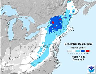
The cyclone was rated by meteorology researchers Kocin and Uccellini (2004) as a high-end Category 3 on the Northeast Snowfall Impact Scale, equating to a "major" winter storm. [8] However, more recent data from the National Climatic Data Center classifies the nor'easter as a low-end "crippling" Category 4. [2] By December 30, at least 20 deaths in New York and New England had been attributed to the storm, largely from traffic accidents and physical exhaustion. [20]

Areas of northeastern Pennsylvania, eastern New York, and Vermont received snowfall in excess of 20 in (51 cm), including 29.8 in (760 mm) at Burlington, 26.4 in (67 cm) at Albany, and 21.9 in (56 cm) at Binghamton, New York. [8] Accumulations locally exceeded 40 in (100 cm), [21] with 45 in (110 cm) measured at Waitsfield, Vermont and 48 in (120 cm) in the small village of East Wallingford, Vermont. [5] [22] The storm remains one of the greatest on record in cities like Albany and Burlington, and contributed to high monthly snowfall totals; in Albany, December 1969 stands as the snowiest documented month, with 57.5 in (146 cm). [21] [23] Throughout the region, the weight of the snow, combined with gale-force winds, collapsed roofs and brought down power lines. [24] The winds blew snow from this and previous storms into drifts as high as 30 ft (9 m), [25] blocking roads and leaving some communities isolated. [20] In some areas, travel was only possible with snowmobiles, which were used by emergency workers to deliver emergency supplies as needed. Rescuers also used snowmobiles and aircraft to search for stranded residents and travelers. [5] [20] Many cities and counties throughout the Northeast issued snow emergencies. [12] [26] Business and industry suffered extensively in the days following the storm. [12]

While major highways were generally cleared by December 29, [4] some local roads reportedly remained covered for up to a month. [21] About 230 mi (370 km) of the New York State Thruway—nearly half its total length—was closed for 27 hours. [27] [28] The snowfall also caused widespread property damage, as the roofs of barns, sheds, and other buildings caved in under the weight of the snow. An airport hangar in Oneonta collapsed, destroying five aircraft inside. In the aftermath of the storm, many homes sustained water damage from melting snow. "Innumerable" traffic accidents were reported, and many motorists became stranded or were forced to abandon their vehicles. [12] Four people in a stalled automobile died of carbon monoxide poisoning. Also in New York, one man froze to death, and three individuals were killed in a building collapse. [12] In the Capital District, the snow fell with a high water content, occasionally mixing with freezing rain. As a result, it was much denser than normal and proved difficult to manage. The City of Albany spent a record $2 million USD on snow removal, [21] and the city restricted nearly all traffic except for vehicles necessary to maintain emergency supplies. [20] Governor Nelson Rockefeller closed state offices in Albany on December 29 and 30, in an effort to enable efficient snow removal. [29] Mayor Erastus Corning 2nd assessed the situation as a "dire emergency". [30]

Map of the nor'easter on December 27 over eastern New England Nor'easter 1969-12-27 weather map.jpg
Map of the nor'easter on December 27 over eastern New England

Governor Deane C. Davis of Vermont declared a state of emergency and ordered the National Guard to assist with cleanup efforts. [31] Blowing snow continuously blocked roads after being cleared, and snow removal vehicles, not equipped to withstand the excessive snow, began experiencing mechanical issues. The storm left some communities without power or telephone service for up to two days, although isolated outages persisted longer. [20] One person died in Saxtons River. [5] With roads impassable in both New York and New England, tank trucks could not reach dairy farmers, who were in some cases forced to discard thousands of gallons of milk. [12] [25] In other cases, power outages rendered equipment useless, requiring milking to be done manually. [20] One person in New Hampshire died of exhaustion during the storm. [12]

The influx of warm, moist air over a wedge of cold air near the surface resulted in a severe ice storm across central and northern New England, most notably in the upper Connecticut River Valley. Glaze ice thicker than 2 in (51 mm), and reportedly up to 6 in (150 mm) thick in Vermont, built up on trees and power lines, wreaking "unbelievable" havoc. [5] In the hardest-hit areas, damage from the ice storm was comparable to that caused by the 1938 New England hurricane. [12] The combined load of snow and ice caused significant damage to many residential and industrial buildings, with several factory and warehouse roofs collapsing. [5] [32] Livestock were killed in multiple rural building collapses throughout the area. [5] Southern Maine endured its second damaging ice storm in a week, with many of the same communities losing power on both occasion. [6] Precipitation also transitioned to freezing rain and sleet across interior Connecticut, where the dangerous conditions induced numerous traffic accidents. [11] Due to the abnormally cold temperatures in the wake of the storm, the glaze persisted for up to six weeks, much longer than the typical three days for ice storms in New England. [32]

The changeover to heavy rain in southern and eastern New England swelled frozen rivers, creating ice jams which induced severe flooding. Flooding of roadways and homes was compounded by drainage issues from the dense snowcover. [6] Rising floodwaters forced hundreds of families to leave their homes in Massachusetts, New Hampshire, and Maine. Up to 4 in (100 mm) of rain fell in the Boston region, where thousands of homes were inundated. Rivers had begun to recede by December 29 after cresting well above flood stage. [31] [33] Up to 4 in (100 mm) of rain fell over Rhode Island after 6 to 11 in (15 to 28 cm) of snow, with widespread flooding reported in multiple towns. Frequent automobile accidents and large traffic jams were reported in the state. [5] Winds were strongest in Cape Cod, Massachusetts, where gusts peaked near 100 mph (160 km/h). The gales were particularly damaging to trees laden with snow and ice. The heavy rainfall in eastern Massachusetts added tremendous weigh to the snow that had already fallen, causing roof collapses and making it difficult to clear the snow. In southeastern New Hampshire, the strong winds toppled trees and blew out windows in Hampton Beach. [12] Although the coastal plain of New England avoided the heaviest snow accumulations, pounding surf and strong winds battered piers, boats, and other coastal installations, while low-lying areas experienced storm surge flooding. [34]

Quebec

The storm dropped up to 30 in (75 cm) of snow in southern Quebec, where wind gusts up to 50 mph (80 km/h) damaged buildings and brought down power lines. [35] Over a period of 60 hours, 27.5 in (70 cm) of snow fell at Montreal in what was then the city's heaviest snowfall on record. Rail, air, and automobile transportation were paralyzed. [36] One individual in Quebec City was struck and killed by a snowplow, and two more died of exposure to cold while ice fishing on the St. Lawrence River. Several fires broke out in Montreal during the storm, killing at least six people and leaving 23 families homeless. [35] In total, the storm was connected to at least 15 fatalities in the province. [36] [37]

See also

Related Research Articles

<span class="mw-page-title-main">Blizzard</span> Type of snowstorm

A blizzard is a severe snowstorm characterized by strong sustained winds and low visibility, lasting for a prolonged period of time—typically at least three or four hours. A ground blizzard is a weather condition where snow is not falling but loose snow on the ground is lifted and blown by strong winds. Blizzards can have an immense size and usually stretch to hundreds or thousands of kilometres.

The Northeast Snowfall Impact Scale (NESIS) was created to measure snowstorms in the U.S. Northeast in much the same way the Saffir-Simpson Hurricane Scale records hurricane intensity and the Enhanced Fujita Scale with tornadoes.

<span class="mw-page-title-main">Mid-December 2007 North American winter storms</span>

The Mid-December 2007 North American winter storms were a series of two winter storms that affected much of central and eastern North America, from December 8 to December 18, 2007. The systems affected areas from Oklahoma to Newfoundland and Labrador with freezing rain, thunderstorms, sleet, snow, damaging winds, and blizzard-like conditions in various areas. The first two storms produced copious amounts of ice across the Midwestern United States and Great Plains from December 8 to December 11, knocking out power to approximately 1.5 million customers from Oklahoma north to Iowa. The second storm moved northeast, producing heavy snow across New York and New England. A third storm was responsible for a major winter storm from Kansas to the Canadian Maritimes, bringing locally record-breaking snowfalls to Ontario, an icestorm across the Appalachians, and thunderstorms and 9 tornadoes to the Southeastern United States.

<span class="mw-page-title-main">December 2000 nor'easter</span>

The December 2000 nor'easter was a significant winter storm that impacted the Mid-Atlantic and New England regions of the United States around the end of the month. It began as an Alberta clipper that moved southeastward through the central United States and weakened over the Ohio Valley. However, it redeveloped off the coast of North Carolina and moved northward as it intensified. It moved into central Long Island and eventually tracked northward into New England. The storm dropped heavy precipitation throughout the Northeast, especially in northern New Jersey and eastern New York, where snowfall often exceeded 2 ft (0.61 m). Even so, as it struck on a weekend, its effects were generally minor and mostly limited to travel delays, traffic accidents, and business closures.

<span class="mw-page-title-main">February 1995 nor'easter</span> Significant extratropical cyclone

The February 1995 nor'easter was a significant nor'easter that impacted the Mid-Atlantic and New England regions of the United States around the beginning of the month. It was the only major nor'easter of the 1994–1995 winter.

<span class="mw-page-title-main">February 1987 nor'easter</span>

The February 1987 nor'easter was a significant winter storm in the US that impacted the Mid-Atlantic States around the end of the month. It delivered 8–12 hours of heavy, wet snowfall to several states from West Virginia to New York between February 22 and February 24. The storm was both preceded and followed by relatively warm temperatures, causing the snow to rapidly melt. The mild conditions were the result of a moderate anticyclone over the region that deteriorated as the nor'easter approached. Cold air damming likely took place prior to the storm's formation.

<span class="mw-page-title-main">February 1969 nor'easter</span> 1969 storm in the United States

The February 1969 nor'easter was a severe winter storm that affected the Mid-Atlantic and New England regions of the United States between February 8 and February 10. The nor'easter dropped paralyzing snowfall, exceeding 20 in (51 cm) in many places. New York City bore the brunt of the storm, suffering extensive disruption. Thousands of travelers became stranded on roads and in airports. The storm killed at least 94 people. City schools were closed for several days and some areas of the city remained uncleared for over a week. New York Mayor John Lindsay was criticized for failing to respond to the snowstorm adequately.

<span class="mw-page-title-main">March 18–20, 1956, nor'easter</span>

The March 18–20, 1956 nor'easter was a significant winter storm in the United States that affected the Mid-Atlantic States and southern New England. The storm ranked as Category 1, or "notable", on the Northeast Snowfall Impact Scale. A high-pressure area north of New York State, developing in the wake of another system on March 15–16, provided cold air for the snowfall. It was among a series of snowstorms to affect the region during the month.

<span class="mw-page-title-main">March 18–22, 1958, nor'easter</span>

The March 18–22, 1958 nor'easter was an unusual late-season and violent winter storm that impacted the Mid-Atlantic and New England regions of the United States. Its snowfall extended from North Carolina through Maine.

<span class="mw-page-title-main">February 1952 nor'easter</span>

The February 1952 nor'easter was a significant winter storm that impacted the New England region of the United States. The storm ranked as Category 1, or "notable", on the Northeast Snowfall Impact Scale. Its rapid intensification resulted in heavy snowfall between February 17 and 18, accumulating to 12 to 30 inches. High winds also affected central and northern New England. The nor'easter is estimated to have caused 42 fatalities. In Maine, over 1,000 travelers became stranded on roadways. Two ships cracked in two offshore New England during the storm.

<span class="mw-page-title-main">January 1961 nor'easter</span>

The January 1961 nor'easter was a significant winter storm that impacted the Mid-Atlantic and New England regions of the United States. It was the second of three major snowstorms during the 1960–1961 winter. The storm ranked as Category 3, or "major", on the Northeast Snowfall Impact Scale.

<span class="mw-page-title-main">December 1960 nor'easter</span> Early-season winter storm that impacted the Mid-Atlantic and New England of the United States

The December 1960 nor'easter was a significant early-season winter storm that impacted the Mid-Atlantic and New England regions of the United States. Moderate to heavy snowfall fell from West Virginia to eastern Maine, amounting to 10 in (25 cm) or more in parts of 13 states and peaking at 21.4 in (54 cm) at Newark, New Jersey. The storm was accompanied by strong winds, gusting to over 90 mph (140 km/h) in coastal New England, and left in its wake a dangerously cold air mass. The storm originated in a weak low pressure area which formed over the western Gulf of Mexico on December 10. A secondary low developed over South Carolina on the next day, supported by the merger of two troughs aloft. Sliding southeast of New England, the new storm explosively deepened to become a full-fledged nor'easter, with a minimum central air pressure of 966 mbar. It began to weaken over the Canadian Maritimes.

<span class="mw-page-title-main">March 1960 nor'easter</span>

The March 1960 nor'easter was a severe winter storm that impacted the Mid-Atlantic and New England regions of the United States. The storm ranked as Category 4, or "crippling", on the Northeast Snowfall Impact Scale. Northeasterly flow, combined with the storm's slower forward motion, enhanced snowfall across the region. The cyclone began moving away from the United States on March 5. It took place during a stormy period in the affected region, contributing to record snowfall.

<span class="mw-page-title-main">Weather of 2008</span>

Global storm activity of 2008 profiles the major worldwide storms, including blizzards, ice storms, and other winter events, from January 1, 2008 to December 31, 2008. A winter storm is an event in which the dominant varieties of precipitation are forms that only occur at cold temperatures, such as snow or sleet, or a rainstorm where ground temperatures are cold enough to allow ice to form. It may be marked by strong wind, thunder and lightning, heavy precipitation, such as ice, or wind transporting some substance through the atmosphere. Major dust storms, Hurricanes, cyclones, tornados, gales, flooding and rainstorms are also caused by such phenomena to a lesser or greater existent.

<span class="mw-page-title-main">2014–15 North American winter</span> Winter season in North America

The 2014–15 North American winter was frigid and prolifically wintry, especially across the eastern half of North America in the months of January–March. The season began early, with many places in North America experiencing their first wintry weather during mid-November. A period of below-average temperatures affected much of the contiguous United States, and several records were broken. An early trace of snowfall was recorded in Arkansas. There were greater accumulations of snow across parts of Oklahoma as well. A quasi-permanent phenomenon referred to as the polar vortex may have been partly responsible for the cold weather. Temperatures in much of the United States dropped 15 to 35 °F below average by November 19, following a southward "dip" of the polar vortex into the eastern two-thirds of the country. The effects of this dip were widespread, bringing about temperatures as low as 28 °F (−2 °C) in Pensacola, Florida. Following a significant snowstorm there, Buffalo, New York received several feet of snow from November 17–21. In addition, significant winter weather occurred throughout the season, including a major blizzard that struck the Northeastern United States at the end of January, another blizzard that affected much of the Northern United States days later in early February, and several significant snow events paired with very frigid temperatures for much of February.

<span class="mw-page-title-main">2015–16 North American winter</span>

The 2015–16 North American winter was not as frigid across North America and the United States as compared to the 2013–14 and 2014–15 winters. This was mainly due to a strong El Niño, which caused generally warmer-than-average conditions. However, despite the warmth, significant weather systems still occurred, including a snowstorm and flash flooding in Texas at the end of December and a large tornado outbreak at the end of February. The main event of the winter season, by far and large, was when a crippling and historic blizzard struck the Northeastern United States in late January, dumping up to 3 feet of snow in and around the metropolitan areas. Several other smaller snow events affected the Northeast as well, but for the most part the heaviest snowstorms and ice stayed out further west, such as a severe blizzard in western Texas in late December, and a major late-season snowstorm in Colorado in mid-April.

<span class="mw-page-title-main">2010–11 North American winter</span>

The 2010–11 North American winter was influenced by an ongoing La Niña, seeing winter storms and very cold temperatures affect a large portion of the Continental United States, even as far south as the Texas Panhandle. Notable events included a major blizzard that struck the Northeastern United States in late December with up to 2 feet (24 in) of snowfall and a significant tornado outbreak on New Year's Eve in the Southern United States. By far the most notable event was a historic blizzard that impacted areas from Oklahoma to Michigan in early February. The blizzard broke numerous snowfall records, and was one of the few winter storms to rank as a Category 5 on the Regional Snowfall Index. In addition, Oklahoma set a statewide low temperature record in February.

<span class="mw-page-title-main">2017–18 North American winter</span> Weather summary

The 2017–18 North American winter saw weather patterns across North America that were very active, erratic, and protracted, especially near the end of the season, resulting in widespread snow and cold across the continent during the winter. Significant events included rare snowfall in the South, an outbreak of frigid temperatures that affected the United States during the final week of 2017 and early weeks of January, and a series of strong nor'easters that affected the Northeastern United States during the month of March. In addition, flooding also took place during the month of February in the Central United States. Finally the winter came to a conclusion with a powerful storm system that caused a tornado outbreak and blizzard in mid-April. The most intense event, however, was an extremely powerful cyclonic blizzard that impacted the Northeastern United States in the first week of 2018. Similar to the previous winter, a La Niña was expected to influence the winter weather across North America.

<span class="mw-page-title-main">December 15–17, 2020 nor'easter</span> North American noreaster in 2020

The December 15–17, 2020 nor'easter was a powerful nor'easter that hammered the Northeastern United States and produced widespread swaths of over 1 foot (12 in) of snow in much of the region from December 15–17, 2020, ending a 1,000+ day high-impact snowstorm drought in much of the Mid-Atlantic and coastal New England regions. The system developed out of a weak area of low-pressure that first developed over the Central United States producing some snowfall before moving eastward, and by December 16, a new, dominant area of low pressure began to develop along the Southeast coast. This low steadily deepened as it moved along and impacted the Mid-Atlantic coastline, prompting several winter-related advisories and warnings for much of the Northeast.

<span class="mw-page-title-main">2022–23 North American winter</span> Winter season in North America

The 2022–23 North American winter was an unusually warm winter for the east and an unusually cold winter for the west in North America, as it occurred across the continent from late 2022 to early 2023. The winter season in North America began at the winter solstice, which occurred on December 21, 2022, and it ended at the March equinox, which occurred on March 20, 2023. The first day of meteorological winter began on December 1 and unofficially ended on February 28; winter storms may still occur outside of these limits.

References

General

Specific

  1. 1 2 3 4 5 Kocin and Uccellini, p. 473
  2. 1 2 National Climatic Data Center. "The Northeast Snowfall Impact Scale (NESIS)". National Oceanic and Atmospheric Administration. Archived from the original on January 5, 2011. Retrieved January 7, 2011.
  3. Climate Prediction Center. "Observation of Monthly Mean North Atlantic Oscillation". National Oceanic and Atmospheric Administration. Retrieved January 7, 2010.
  4. 1 2 3 A. Boyd Pack (1968). "New York – December 1969: special weather summary". Climatological data. New York, Volumes 80–81. National Climatic Data Center. p. 210. Retrieved January 10, 2016.
  5. 1 2 3 4 5 6 7 8 Storm Data, p. 159
  6. 1 2 3 4 5 Storm Data, p. 156
  7. Northeast Regional Climate Center. "Minimum 1-day mean min temperature for Albany AP, NY". Cornell University. Retrieved January 9, 2016.
  8. 1 2 3 4 5 6 7 8 9 10 Kocin and Uccellini, p. 467
  9. Kocin and Uccellini, p. 469
  10. Kocin and Uccellini, p. 468
  11. 1 2 Storm Data, p. 154
  12. 1 2 3 4 5 6 7 8 9 Storm Data, p. 157
  13. Ian Livingston (December 23, 2012). "Christmas Eve and Christmas Day tornado history". US Tornadoes. Retrieved January 8, 2016.
  14. 1 2 3 Grazulis, p. 502
  15. Storm Data, p. 155
  16. 1 2 Storm Data, pp. 154–155
  17. 1 2 "Snow Piles Quickly in Coast Area". Youngstown Vindicator. Associated Press. December 26, 1969. Retrieved March 10, 2011.
  18. 1 2 Storm Data, pp. 158–159
  19. "For much of the state, a white Christmas". The Daily Times-News. Associated Press. December 26, 1969. Retrieved January 9, 2016 via Newspapers.com. Open Access logo PLoS transparent.svg
  20. 1 2 3 4 5 6 "Northeast Stays Paralyzed By Storm". The Lewiston Morning Tribune. Associated Press. December 30, 1969. Retrieved January 7, 2011.
  21. 1 2 3 4 National Weather Service Albany, New York. "Major Winter Storms". National Oceanic and Atmospheric Administration. Retrieved January 10, 2016.
  22. "Wintry blast buries much of New England". The El Dorado Times. Associated Press. December 29, 1969. Retrieved January 10, 2015 via Newspapers.com. Open Access logo PLoS transparent.svg
  23. "Burlington, Vermont top 20 greatest snowstorms" (PDF). National Weather Service Burlington, Vermont. Retrieved January 10, 2015.
  24. Staff Writer (December 28, 1969). "New England Clogged by 2-Day Snow". The Chicago Tribune. Archived from the original on November 5, 2012. Retrieved January 7, 2011.
  25. 1 2 Lesley-Ann Dupigny-Giroux (2002). "Climate Variability and Socioeconomic Consequences of Vermont's Natural Hazards: A Historical Perspective" (PDF). Vermont Historical Society. Archived from the original (PDF) on July 25, 2011. Retrieved January 7, 2010.
  26. United Press International (December 26, 1969). "Cities declare emergencies: Conn. banks ordered closed". Naugatuck Daily News. Retrieved January 11, 2016 via Newspapers.com. Open Access logo PLoS transparent.svg
  27. United Press International (December 26, 1969). "State-wide storm has caused closing of Thruway". The Daily Messenger. Retrieved January 11, 2016 via Newspapers.com. Open Access logo PLoS transparent.svg
  28. United Press International (December 29, 1969). "Storm closes Albany state offices". The Daily Messenger. Retrieved January 11, 2016 via Newspapers.com.
  29. Charles Dumas (December 30, 1969). "Storm extends state government holiday to five days". The Oneonta Star. Retrieved January 11, 2016 via Newspapers.com. Open Access logo PLoS transparent.svg
  30. Bill Kovachs (December 30, 1969). "Albany Calls 'Dire' Emergency As 26-Inch Snow Paralyzes Area; Albany Declares 'Dire Emergency' After 26-Inch Snowstorm". The New York Times. Retrieved January 7, 2011.
  31. 1 2 "4-Foot Snow, Flood Strangle Northeast". The Modesto Bee. Associated Press. December 29, 1969.
  32. 1 2 S. F. Ackley and K. Itagaki (1970). "Distribution of Icing in the Northeast's Ice Storm of 26–27 December 1969". Weatherwise. 23 (6): 274–279. doi:10.1080/00431672.1970.9932909.
  33. "Vermont Declared a Disaster Area". The Meriden Journal. Associated Press. December 29, 1969. Retrieved January 7, 2011.
  34. Storm Data, pp. 156–157
  35. 1 2 The Canadian Press (December 29, 1969). "Death, destruction in Quebec blizzard". The Brandon Sun. Retrieved January 9, 2016 via Newspapers.com. Open Access logo PLoS transparent.svg
  36. 1 2 Mark E. H. Trueman (1970). "Montreal's great snowstorm of ′69". Weatherwise . 23 (6): 270–273. doi:10.1080/00431672.1970.9932908.
  37. Climat-Quebec. "Significant Climate Events of the 20th Century in Québec". Meteorological Service of Canada. Archived from the original on November 28, 2015. Retrieved January 9, 2016.