Dobbins Heights, North Carolina

Last updated

Dobbins Heights, North Carolina
USA North Carolina location map.svg
Red pog.svg
Dobbins Heights, North Carolina
Location within the state of North Carolina
Coordinates: 34°54′25″N79°41′36″W / 34.90694°N 79.69333°W / 34.90694; -79.69333
Country United States
State North Carolina
County Richmond
Area
[1]
  Total0.88 sq mi (2.29 km2)
  Land0.88 sq mi (2.29 km2)
  Water0.00 sq mi (0.00 km2)
Elevation
[2]
397 ft (121 m)
Population
 (2020)
  Total687
  Density778.03/sq mi (300.48/km2)
Time zone UTC-5 (Eastern (EST))
  Summer (DST) UTC-4 (EDT)
ZIP code
28345
Area codes 910, 472
FIPS code 37-17325 [3]
GNIS feature ID2406381 [2]
Website www.dobbinsheights.com

Dobbins Heights is a town in Richmond County, North Carolina, United States. The population was 866 at the 2010 census.

Contents

Geography

According to the United States Census Bureau, the town has a total area of 0.9 square miles (2.3 km2), all land.

History

Dobbins Heights was originally known as North Yard. It began as a largely black community in an unincorporated part of Richmond County near the city of Hamlet, with fewer than 1,000 residents. [4] A black school, the Pee Dee Institute, was built in North Yard in 1908. [5] Through the 1960s, many of the homes in the community were rented, and existed in poor condition with outdoor plumbing. [6] Many streets remained unpaved through the 1980s. Due to its unincorporated status, North Yard's residents received fewer government services than other municipal residents and lacked direct political representation. They usually paid taxes directly to Richmond County government, though occasionally levies were paid to Hamlet. [7] There was little cohesive community identity in the area; collective social life, such as it existed, was centered around several churches. [8]

A home in Dobbins Heights, 1972 Dobbins Heights, 1972.jpg
A home in Dobbins Heights, 1972

In the mid-1960s, a local minister founded the North Yard Improvement Association, which raised money to install streetlights along some of the main roads in the community. [7] From 1971 to 1972 United States Army engineers built a recreational area in the community. [9] Lack of adequate coverage from neighboring fire departments led the community to create a volunteer fire department in 1974. [10] [11] Two years later residents appealed for the city of Hamlet to annex the community, but the municipal government rejected the proposal, citing the economically depressed nature of the area. [11] Some locals suspected their lack of success was due to racism. Following the failure of the annexation request, residents began pushing for North Yard to be incorporated in its own right, and began calling the community Dobbins Heights in homage to Jim Dobbins, a minister who had owned a significant amount of the area's land in the 1930s. [12] In 1983 Representative Hugh Lee of Rockingham introduced a bill in the North Carolina General Assembly to authorize a local referendum to decide on incorporation. [5] On May 8, 1984, the referendum was held which concluded narrowly in favor of incorporation, leading to the creation of the town of Dobbins Heights. A black mayor and all-black city council were elected, and the officials successfully secured state and federal grants to improve local infrastructure, including the rehabilitation of streets and parks and equipment acquisitions for the fire department. [12]

Demographics

Historical population
CensusPop.Note
1990 1,144
2000 936−18.2%
2010 866−7.5%
2020 687−20.7%
U.S. Decennial Census [13]

2020 census

Dobbins Heights racial composition [14]
RaceNumberPercentage
White (non-Hispanic)7310.63%
Black or African American (non-Hispanic)54579.33%
Native American 60.87%
Asian 10.15%
Other/Mixed 456.55%
Hispanic or Latino 172.47%

As of the 2020 United States census, there were 687 people, 404 households, and 218 families residing in the town.

Related Research Articles

<span class="mw-page-title-main">Petersburg, Virginia</span> Independent city in Virginia, United States

Petersburg is an independent city in the Commonwealth of Virginia in the United States. As of the 2020 census, the population was 33,458 with a majority black American. The Bureau of Economic Analysis combines Petersburg with Dinwiddie County for statistical purposes. The city is 21 miles (34 km) south of the commonwealth (state) capital city of Richmond.

<span class="mw-page-title-main">Henrico County, Virginia</span> County in Virginia, United States

Henrico County, officially the County of Henrico, is located in the Commonwealth of Virginia in the United States. As of the 2020 census, the population was 334,389 making it the fifth-most populous county in Virginia. Henrico County is included in the Greater Richmond Region. There is no incorporated community within Henrico County; therefore, there is no incorporated county seat either. Laurel, an unincorporated CDP, serves this function.

<span class="mw-page-title-main">Yadkin County, North Carolina</span> County in North Carolina, United States

Yadkin County is located in the U.S. state of North Carolina. As of the 2020 census, the population was 37,214. Its county seat is Yadkinville. Yadkin County is included in the Winston-Salem, NC Metropolitan Statistical Area, which is also included in the Greensboro–Winston-Salem–High Point, NC Combined Statistical Area.

<span class="mw-page-title-main">Scotland County, North Carolina</span> County in North Carolina, United States

Scotland County is a county located in the southern part of the U.S. state of North Carolina. Its county seat is and largest community is Laurinburg. The county was formed in 1899 from part of Richmond County and named in honor of the Scottish settlers who occupied the area in the 1700s. As of the 2020 census, its population was 34,174.

<span class="mw-page-title-main">Richmond County, North Carolina</span> County in North Carolina, United States

Richmond County is a county located on the central southern border of the U.S. state of North Carolina. Its county seat is Rockingham. The county was formed in 1779 from a portion of Anson County and named in honor of Charles Lennox, 3rd Duke of Richmond and Lennox. As of the 2020 census, the population was 42,946.

<span class="mw-page-title-main">Hoke County, North Carolina</span> County in North Carolina, United States

Hoke County is a county in the U.S. state of North Carolina. As of the 2020 census, its population was 52,082. Its county seat is Raeford.

<span class="mw-page-title-main">East Richmond Heights, California</span> Unincorporated community in California, United States

East Richmond Heights is an unincorporated community and census-designated place (CDP) in western Contra Costa County, California, United States. Its population was 3,280 at the 2010 census.

<span class="mw-page-title-main">Somerset, Maryland</span> Town in Maryland, United States

Somerset is an incorporated town in Montgomery County, Maryland, United States, located near the border with Washington, D.C. The population was 1,187 at the 2020 census.

<span class="mw-page-title-main">Forest Heights, Maryland</span> Town in Maryland

Forest Heights is a town in Prince George's County, Maryland, United States, and is part of the larger postal designation of Oxon Hill. The town straddles both sides of dual-lane Maryland Route 210 and includes two elementary schools. Per the 2020 census, the population was 2,658.

<span class="mw-page-title-main">Hamlet, North Carolina</span> City in North Carolina, United States

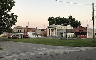
Hamlet is a city in Richmond County, North Carolina, United States. The population was 6,042 at the 2020 census.

<span class="mw-page-title-main">Rockingham, North Carolina</span> City in North Carolina, United States

Rockingham is a city in Richmond County, North Carolina, United States, named after the Marquess of Rockingham. The population was 9,558 at the 2010 census. It is the county seat of Richmond County.

<span class="mw-page-title-main">Gibson, North Carolina</span> Town in North Carolina, United States

Gibson is a town in Scotland County, North Carolina, United States. The population was 540 at the 2010 census.

<span class="mw-page-title-main">Apex, North Carolina</span> Town in North Carolina, United States

Apex is a town in Wake County, North Carolina, United States. At its southern border, Apex encompasses the community of Friendship. In 1994, the downtown area was designated a historic district, and the Apex train depot, built in 1867, is designated a Wake County landmark. The depot location marks the highest point on the old Chatham Railroad, hence the town's name. The town motto is "The Peak of Good Living".

<span class="mw-page-title-main">Darien, Connecticut</span> Town in Connecticut, United States

Darien is a coastal town in Fairfield County, Connecticut, United States. With a population of 21,499 and a land area of just under 13 square miles (34 km2), it is the smallest town on Connecticut's Gold Coast. The town is part of the Western Connecticut Planning Region. It has a high rate of marriage, and high average number of children per household.

<span class="mw-page-title-main">Colonie, New York</span> Town in New York, United States

Colonie is a town in Albany County, New York, United States. It is the most-populous suburb of Albany, and is the third-largest town in area in Albany County, occupying approximately 11% of the county. Several hamlets exist within the town. As of the 2020 census, the town had a total population of 85,590.

<span class="mw-page-title-main">Poughkeepsie (town), New York</span> Town in New York, United States

Poughkeepsie, officially the Town of Poughkeepsie, is a town in Dutchess County, New York, United States. As of the 2020 United States Census, the population was 45,471. The name is derived from the native compound Uppuqui-ipis-ing, from Uppuqui meaning "lodge-covered", plus ipis meaning "little water", plus ing meaning "place", all of which translates to "the reed-covered lodge by the little water place". This later evolved into Apokeepsing, then into Poughkeepsing, and finally Poughkeepsie.

<span class="mw-page-title-main">Administrative divisions of New York (state)</span>

The administrative divisions of New York are the various units of government that provide local services in the American state of New York. The state is divided into boroughs, counties, cities, towns, and villages. They are municipal corporations, chartered (created) by the New York State Legislature, as under the New York State Constitution the only body that can create governmental units is the state. All of them have their own governments, sometimes with no paid employees, that provide local services. Centers of population that are not incorporated and have no government or local services are designated hamlets. Whether a municipality is defined as a borough, city, town, or village is determined not by population or land area, but rather on the form of government selected by the residents and approved by the New York State Legislature. Each type of local government is granted specific home rule powers by the New York State Constitution. There are still occasional changes as a village becomes a city, or a village dissolves, each of which requires legislative action. New York also has various corporate entities that provide local services and have their own administrative structures (governments), such as school and fire districts. These are not found in all counties.

Honeoye is a hamlet in the Town of Richmond, in Ontario County, New York, United States. The population was 579 at the 2010 census, which lists the community as a census-designated place (CDP).

<span class="mw-page-title-main">Hamlet chicken processing plant fire</span> 1991 industrial fire in Hamlet, North Carolina, US

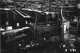
On September 3, 1991, an industrial fire caused by a failed improvised repair to a hydraulic line destroyed the Imperial Food Products chicken processing plant in Hamlet, North Carolina. Despite three previous fires in 11 years of operation, the plant had never received a safety inspection. The fire killed 25 people and injured 54, many of whom were unable to escape due to locked exits. It was the second deadliest industrial disaster in North Carolina's history.

<span class="mw-page-title-main">North Carolina Highway 177</span> State highway in Richmond County, North Carolina, US

North Carolina Highway 177 (NC 177) is a 16-mile-long (26 km) route in the piedmont region of North Carolina. The road runs from South Carolina Highway 177 (SC 177) at the North Carolina-South Carolina border, through the town of Hamlet to U.S. Highway 1 (US 1) just south of Hoffman and just north of Rockingham. NC 177 was created in 1961 as a renumbering of NC 77.

References

  1. "ArcGIS REST Services Directory". United States Census Bureau. Retrieved September 20, 2022.
  2. 1 2 U.S. Geological Survey Geographic Names Information System: Dobbins Heights, North Carolina
  3. "U.S. Census website". United States Census Bureau . Retrieved January 31, 2008.
  4. Simon 2020, pp. 23–24, 191.
  5. 1 2 Simmons-Henry 1990, p. 228.
  6. Simon 2020, pp. 23–24.
  7. 1 2 Simon 2020, p. 191.
  8. Noland 1972, p. 25.
  9. "Domestic Action Program Dates Back to Pioneer Days". Commanders Digest. Vol. 13, no. 10. United States Department of Defense. January 11, 1973. pp. 6–7.
  10. Simon 2020, pp. 191–192.
  11. 1 2 Arrington, Fran (December 9, 1991). "Dobbins Heights, Hamlet worlds apart". The News & Observer. p. 9A.
  12. 1 2 Simon 2020, p. 192.
  13. "Census of Population and Housing". Census.gov. Retrieved June 4, 2015.
  14. "Explore Census Data". data.census.gov. Retrieved December 22, 2021.

Works cited