Grandy is an unincorporated community and census-designated place (CDP) in Currituck County, North Carolina, USA. It was first listed as a CDP in the 2020 census with a population of 2,776. It is located along US 158 between the Currituck Sound and the North River.
Beech Island is an unincorporated community and census-designated place (CDP) in Aiken County, South Carolina, United States. It was first listed as a CDP in the 2020 census with a population of 1,421.

Alexis is an unincorporated community and census-designated place (CDP) in Gaston County, North Carolina, United States. It is located approximately three miles north of Stanley. It was first listed as a CDP in the 2020 census with a population of 589.

Springdale is an unincorporated community and census-designated place (CDP) in Gaston County, North Carolina, United States. It was first listed as a CDP in the 2020 census with a population of 1,203. It is bordered on the west and south by the City of Gastonia, on the east by the town of Ranlo, and on the north by the unincorporated community of Monterey Park.

Hamer is an unincorporated community and census-designated place (CDP) in Dillon County, South Carolina, United States. It was first listed as a CDP in the 2020 census with a population of 820.
Milwaukee is an unincorporated community and census-designated place (CDP) in Northampton County, North Carolina, United States. It was first listed as a CDP in the 2020 census with a population of 157.
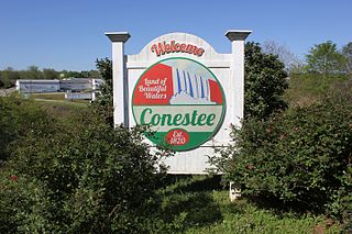
Conestee is an unincorporated community and census-designated place (CDP) in Greenville County, South Carolina, United States. It was first listed as a CDP in the 2020 census with a population of 904.
Cypress Landing is a planned community and census-designated place (CDP) in Beaufort County, North Carolina, United States. It was first listed as a CDP in the 2020 census with a population of 1,257.
Emma is an unincorporated community and census-designated place (CDP) in Buncombe County, North Carolina, United States. It was first listed as a CDP in the 2020 census with a population of 2,174.
Brandywine Bay is a planned community and census-designated place (CDP) in Carteret County, North Carolina, United States. It was first listed as a CDP in the 2020 census with a population of 1,153.
Carolina Meadows is a planned community and census-designated place (CDP) in Chatham County, North Carolina, United States. It was first listed as a CDP in the 2020 census with a population of 727.
Governors Club is a golf course community and census-designated place (CDP) in Chatham County, North Carolina, United States. It was first listed as a CDP in the 2020 census with a population of 1,969.
Cherry Branch is a planned community and census-designated place (CDP) in Craven County, North Carolina, United States. It was first listed as a CDP in the 2020 census with a population of 1,211.
Graingers is an unincorporated community and census-designated place (CDP) in Lenoir County, North Carolina, United States. It was first listed as a CDP in the 2020 census with a population of 229.
Long Creek is an unincorporated community and census-designated place (CDP) in Pender County, North Carolina, United States. It was first listed as a CDP in the 2020 census with a population of 277.
Unity is an unincorporated community and census-designated place (CDP) in Lancaster County, South Carolina, United States. It was first listed as a CDP prior to the 2020 census with a population of 325.
Ashwood is an unincorporated community and census-designated place (CDP) in Lee County, South Carolina, United States. It was first listed as a CDP prior to the 2020 census which showed a population of 116.
White Knoll is an unincorporated area and census-designated place (CDP) in Lexington County, South Carolina, United States. It was first listed as a CDP prior to the 2020 census with a population of 7,858.
The Cliffs Valley is a resort community and census-designated place (CDP) in Greenville County, South Carolina, United States. It was first listed as a CDP prior to the 2020 census with a population of 736.
Baxter Village is a planned community and census-designated place (CDP) in York County, South Carolina, United States. It was first listed as a CDP prior to the 2020 census which showed a population of 4,217.


