Ellerbe, North Carolina

Last updated

Ellerbe, North Carolina
Ellerbe, North Carolina.jpg
USA North Carolina location map.svg
Red pog.svg
Ellerbe, North Carolina
Location within the state of North Carolina
Coordinates: 35°04′19″N79°45′35″W / 35.07194°N 79.75972°W / 35.07194; -79.75972
Country United States
State North Carolina
County Richmond
Government
  MayorBrenda Capel
Area
[1]
  Total1.32 sq mi (3.42 km2)
  Land1.31 sq mi (3.41 km2)
  Water0.00 sq mi (0.01 km2)
Elevation
[2]
528 ft (161 m)
Population
 (2020)
  Total864
  Density657.03/sq mi (253.60/km2)
Time zone UTC-5 (Eastern (EST))
  Summer (DST) UTC-4 (EDT)
ZIP code
28338
Area codes 910, 472
FIPS code 37-20840 [3]
GNIS feature ID2406441 [2]

Ellerbe is a town in Richmond County, North Carolina, United States. The population was 1,054 at the 2010 census.

Contents

History

In the 1700s Scottish settlers held a fair every May and November in the present location of Ellerbe, leading locals to dub the place "the Fair Grounds". W. T. Ellerbe later developed a spa nearby called Ellerbe Springs, and thereafter the community took its name. [4] A railroad was built to Ellerbe in 1910 and a depot was constructed. [5] The town was incorporated the following year. [4] At the time it only had a population of 50. By 1923 it had grown to a population of over 500, with several mills, two banks, three churches, a telephone exchange, and a hotel. [6] The rail line remained in service until 1954, and the depot burnt down several years later. [5]

Geography

According to the United States Census Bureau, the town has a total area of 1.5 square miles (3.9 km2), all land.

Demographics

Historical population
CensusPop.Note
1920 473
1930 61530.0%
1940 69312.7%
1950 77311.5%
1960 8439.1%
1970 9138.3%
1980 1,12923.7%
1990 1,1320.3%
2000 1,021−9.8%
2010 1,0543.2%
2020 864−18.0%
U.S. Decennial Census [7]

2020 census

Ellerbe racial composition [8]
RaceNumberPercentage
White (non-Hispanic)39946.18%
Black or African American (non-Hispanic)27031.25%
Native American 212.43%
Asian 10.12%
Other/Mixed 637.29%
Hispanic or Latino 11012.73%

As of the 2020 United States census, there were 864 people, 398 households, and 284 families residing in the town.

2000 census

As of the census [3] of 2000, there were 1,021 people, 398 households, and 269 families residing in the town. The population density was 696.9 inhabitants per square mile (269.1/km2). There were 447 housing units at an average density of 305.1 per square mile (117.8/km2). The racial makeup of the town was 48.68% White, 46.13% African American, 0.20% Native American, 0.10% Asian, 4.90% from other races. Hispanic or Latino of any race were 8.42% of the population.

There were 398 households, out of which 32.7% had children under the age of 18 living with them, 37.9% were married couples living together, 25.4% had a female householder with no husband present, and 32.4% were non-families. 29.6% of all households were made up of individuals, and 13.8% had someone living alone who was 65 years of age or older. The average household size was 2.55 and the average family size was 3.16.

In the town, the population was spread out, with 30.7% under the age of 18, 7.8% from 18 to 24, 26.2% from 25 to 44, 19.8% from 45 to 64, and 15.5% who were 65 years of age or older. The median age was 33 years. For every 100 females, there were 82.3 males. For every 100 females age 18 and over, there were 74.8 males.

The median income for a household in the town was $21,118, and the median income for a family was $29,091. Males had a median income of $25,625 versus $16,544 for females. The per capita income for the town was $12,327. About 27.9% of families and 29.5% of the population were below the poverty line, including 42.9% of those under age 18 and 17.5% of those age 65 or over.

Arts and culture

The Bostick School, Ellerbe Springs Hotel, Liberty Hill School, and Powell-Brookshire-Parker Farm are listed on the National Register of Historic Places. [9]

Notable people

Related Research Articles

<span class="mw-page-title-main">Montgomery County, North Carolina</span> County in North Carolina, United States

Montgomery County is a rural county located in the southern Piedmont of the U.S. state of North Carolina. As of the 2020 census, the population was 25,751. Its county seat is Troy.

<span class="mw-page-title-main">Richmond County, North Carolina</span> County in North Carolina, United States

Richmond County is a county located on the central southern border of the U.S. state of North Carolina. Its county seat is Rockingham. The county was formed in 1779 from a portion of Anson County and named in honor of Charles Lennox, 3rd Duke of Richmond and Lennox. As of the 2020 census, the population was 42,946.

<span class="mw-page-title-main">Mooresboro, North Carolina</span> Town in North Carolina, United States

Mooresboro is a town in Cleveland County, North Carolina, United States. The population was 311 at the 2010 census.

Cerro Gordo is a town in Columbus County, North Carolina, United States. The population was 207 at the 2010 census.

<span class="mw-page-title-main">Stokesdale, North Carolina</span> Town in North Carolina, United States

Stokesdale is a town in Guilford County, North Carolina, United States with small parts in the counties of Rockingham, Forsyth, and Stokes. The population was 5,924 at the 2020 census. Belews Lake is located nearby, and North Carolina Highway 68 and North Carolina Highway 65 both intersect U.S. Route 158 near the town's center.

<span class="mw-page-title-main">Seaboard, North Carolina</span> Town in North Carolina, United States

Seaboard is a township in Northampton County, North Carolina, United States, created as a company town by the Seaboard and Roanoke Railroad, approximately 10 miles northeast of Weldon in the mid-1840s as a place for railroad employees to live.

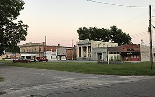
East Rockingham is a census-designated place (CDP) in Richmond County, North Carolina, United States. The population was 3,885 at the 2000 census.

<span class="mw-page-title-main">Hamlet, North Carolina</span> City in North Carolina, United States

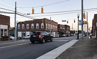
Hamlet is a city in Richmond County, North Carolina, United States. The population was 6,042 at the 2020 census.

<span class="mw-page-title-main">Rockingham, North Carolina</span> City in North Carolina, United States

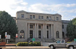
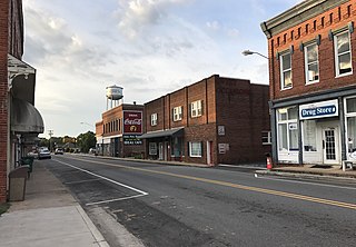
Rockingham is a city in Richmond County, North Carolina, United States, named after the Marquess of Rockingham. The population was 9,558 at the 2010 census. It is the county seat of Richmond County.

Orrum is a town in Robeson County, North Carolina, United States. The population was 91 at the 2010 census.

<span class="mw-page-title-main">Rowland, North Carolina</span> Town in North Carolina, United States

Rowland is a town in Rowland Township, Robeson County, North Carolina, United States. The population was 1,037 at the 2010 census.

<span class="mw-page-title-main">Madison, North Carolina</span> Town in North Carolina, United States

Madison is a town located in Rockingham County, North Carolina. At the 2020 census, the town had a total population of 2,132. Madison is part of the Greensboro-High Point Metropolitan Statistical Area of the Piedmont Triad metro region. It was home to the corporate headquarters of Remington Arms until 2020, when the company was made defunct by bankruptcy proceedings. It is still home to Marlin Firearms, which was an asset of Remington now owned by Sturm, Ruger & Co.

<span class="mw-page-title-main">Mayodan, North Carolina</span> Town in North Carolina, United States

Mayodan is a town in Rockingham County, North Carolina, in the United States. It is a manufacturing site for Sturm, Ruger & Co., Bridgestone Aircraft Tire, and formerly General Tobacco. Washington Mills Company, later Tultex, operated a textile mill in Mayodan until 1999.

<span class="mw-page-title-main">Reidsville, North Carolina</span> City in North Carolina, United States

Reidsville is a city in Rockingham County in the U.S. state of North Carolina. At the 2020 census, the city had a total population of 14,583. Reidsville is included in the Greensboro–High Point Metropolitan Statistical Area of the Piedmont Triad.

<span class="mw-page-title-main">Stoneville, North Carolina</span> Town in North Carolina, United States

Stoneville is a town in Rockingham County, North Carolina, United States. Stoneville is part of the Greensboro–High Point metropolitan area of the Piedmont Triad. At the 2020 United States census, the town had a population of 1,308.

<span class="mw-page-title-main">Wentworth, North Carolina</span> Town in Rockingham County

Wentworth is a town in Rockingham County, North Carolina, United States. The population was 2,646 at the 2020 census. Wentworth is the county seat of Rockingham County and is part of the Greensboro-High Point metropolitan area of the Piedmont Triad. On May 6, 2022, an EF-1 Tornado hit Wentworth. The storm traveled as a supercell with crazy structure from the Pilot Mountain, North Carolina, and Pinnacle, North Carolina, area across central Stokes County and into Rockingham County. It took out trees, damaged homes, and blocked roads before it lifted off southwest of Reidsville.

<span class="mw-page-title-main">Gibson, North Carolina</span> Town in North Carolina, United States

Gibson is a town in Scotland County, North Carolina, United States. The population was 540 at the 2010 census.

<span class="mw-page-title-main">Laurinburg, North Carolina</span> City in North Carolina, United States

Laurinburg is a city in and the county seat of Scotland County, North Carolina, United States. Located in southern North Carolina near the South Carolina border, Laurinburg is southwest of Fayetteville and is home to St. Andrews University. The population at the 2010 census was 15,962 people.

<span class="mw-page-title-main">Wagram, North Carolina</span> Town in North Carolina, United States

Wagram is a town in Scotland County, North Carolina, United States. The population was 840 at the 2010 census. The town was named for the Battle of Wagram, a Napoleonic battle at Deutsch-Wagram in Austria.

<span class="mw-page-title-main">Millers Creek, North Carolina</span> CDP in North Carolina, United States

Millers Creek is a census-designated place (CDP) in Wilkes County, North Carolina, United States. The population was 2,112 at the 2010 census. West Wilkes High School, one of the four public high schools in Wilkes County, is located in Millers Creek.

References

  1. "ArcGIS REST Services Directory". United States Census Bureau. Retrieved September 20, 2022.
  2. 1 2 U.S. Geological Survey Geographic Names Information System: Ellerbe, North Carolina
  3. 1 2 "U.S. Census website". United States Census Bureau . Retrieved January 31, 2008.
  4. 1 2 Powell 1976, p. 161.
  5. 1 2 Carriker & Linder 1982, p. 1.
  6. "What About Ellerbe". Rockingham Post-Dispatch. Vol. 6, no. 47 (Ellerbe Fair ed.). October 18, 1923. pp. 13, 20.
  7. "Census of Population and Housing". Census.gov. Retrieved June 4, 2015.
  8. "Explore Census Data". data.census.gov. Retrieved December 22, 2021.
  9. "National Register Information System". National Register of Historic Places . National Park Service. July 9, 2010.
  10. Henry E. Frye (1932- ) - North Carolina History Project Retrieved July 25, 2018.
  11. "Senator Tom McInnis - Biography - North Carolina General Assembly". ncleg.gov. Retrieved September 22, 2020.
  12. Benny Parsons Obituary | Benny Parsons Funeral | Legacy.com Retrieved July 25, 2018.