Drukken Steps

Last updated

The site of the Drukken Steps over the Red Burn on the 1774 Toll road to Millburn via Higgens House Drucken steps.JPG
The site of the Drukken Steps over the Red Burn on the 1774 Toll road to Millburn via Higgens House

The Drukken, Drucken Steps or Drunken Steps were stepping stones across the Red Burn in Irvine, North Ayrshire, Scotland and are associated with Scotland's national poet, Robert Burns. Drukken is used on the commemorative cairn plaque, [2] but Druken or Drucken may also be used.

Contents

The site of the Drukken Steps

The 1960s bridge abutment at the site of the old Drukken Steps of circa 1966 with the old Toll Road route in the background Drukken Steps Bridges.JPG
The 1960s bridge abutment at the site of the old Drukken Steps of circa 1966 with the old Toll Road route in the background
The site of the Drukken Steps. Redburn and the Drukken Steps, Irvine.JPG
The site of the Drukken Steps.

The Drukken, or in English, the 'Drunken Steps' in the old Eglinton Woods near Stanecastle at NS 329 404, were a favourite haunt of Burns and his friend Richard Brown whilst the two were in Irvine in 1781 – 82. A commemorative cairn off Bank Street at MacKinnon Terrace in Irvine, next to the expressway, stands several hundred yards from the site of the Drukken stepping stones across the Red Burn, also said to be the site of Saint Bryde's, Brides or Bridget's well. Until 2009 it was generally thought that the Drukken Steps had been buried beneath the road surface of the Kilwinning bypass. [3]

In 1799 the Earl closed the road beyond the Drucken Steps to 'protect' his new policies, providing a diversion which ran via Knadgerhill. [4]

The stepping stones remained in situ without any bridge present until at least the late 1960s. The Red Burn was wider with a greater flow at that time, and the flow would have been even greater when Littlestane Loch, located near the old farm of that name, still existed.

The original plaque had been inserted in the old estate boundary wall at the site of the stepping stones, having been donated to the Irvine Burns Club by Sir Andrew R. Duncan of Irvine in 1927. [5]

Origin of the name

The name 'Drukken' steps derives from a person's apparently drunken gait as they stepped from stone to stone whilst crossing the burn. Seven or more stones were originally set in the Red Burn which was much wider than now (2009).[ citation needed ] Burns himself used the Scots spelling 'Drucken' rather than 'Drukken' or 'Druken'. [6] The Scots word 'drouk', meaning 'drench' is another possible derivation. Strawhorn refers to the site as the 'Drunken Steps' [7] or 'Drucken Steps'. [4]

The commemorative cairn

The Drukken Steps / Saint Bryde's Well commemorative cairn as relocated in 1976. Drukken Cairn - Saint Bryde's Well.JPG
The Drukken Steps / Saint Bryde's Well commemorative cairn as relocated in 1976.
The old estate wall foundations at the Drukken Steps Drukken Steps wall.JPG
The old estate wall foundations at the Drukken Steps

The lower inscription (1927) on the commemorative cairn states:

Eglinton Woods, Drukken Steps (St Bryde's Well), Favourite Walk (1781–82) of Robert Burns and his sailor friend Richard Brown. "Do you recollect a Sunday we spent together in Eglinton Woods? R.B." 30 December 1787. Irvine Burns Club, 25 January 1927.

The upper inscription (1976) reads:

This cairn was erected for Irvine Burns Club to mark their 150th anniversary and to re-locate the plaque originally placed at the Drukken Steps (Drunken) / Saint Bride's Well. [9] 700 yards north west of this spot by W & C French (Construction) Ltd, builders of Irvine by-pass, January 1976.

The 'Steps Road' in Irvine commemorates the Drukken steps. [8]

The stepping stones and the 1774 toll road

The commemorative plaque on the Drukken Cairn as first unveiled by Sir Andrew Duncan, Irvine Burns Club President. Drukken Cairn Plaque.JPG
The commemorative plaque on the Drukken Cairn as first unveiled by Sir Andrew Duncan, Irvine Burns Club President.

The Drukken Steps therefore were stepping stones on the course of an old Road, later a Toll Road (1774), which ran from the west end of Irvine through the Eglinton policies to Kilwinning and Stevenston via Milnburn (sic) or Millburn; [11] crossing the Red burn near Knadgerhill (previously Knadgar and pronounced 'Nygerhill'[ citation needed ] as in the country. [12] ) and running passed 'The Higgins' cottage, the 'Hygenhouse' of 1774, [11] now demolished. The name may be a personal name or may relate to the Scots word for a fence or hedge as the building lay close to the boundary of the estate. [13] 55°37.902′N004°39.355′W / 55.631700°N 4.655917°W / 55.631700; -4.655917 The Eglinton estate wall used to cut across the burn and join up with the perimeter wall of the cemetery. The remains of this wall can still be seen at the site of the stepping stones and it was to this wall that the original commemorative plaque had been attached. No gate or door existed here, entry being gained through a collapsed section. The nearby Knadgerhill Cemetery has one wall built from a continuation of this estate wall.

Knadgerhill Cemetery wall, incorporating the estate wall. Knadger Hill cemetery wall, Irvine.JPG
Knadgerhill Cemetery wall, incorporating the estate wall.

Land in the vicinity of the Drukken Steps was locally known as the Spittal Meadow, [14] held in 1666 by the Laird of Corsbie or Crosbie and Robert Woodside or Robert of Woodside. [15] Spittal was a term chiefly applied to lands, the revenues of which supported a hospice but, in some instances, the reference maybe to the site of a hospice for the infirm, lepers, etc. This name is also recorded in a document dated 1542. [2] [16] This could have formed part of the lands of the nunnery at Stanecastle which could have been the site of the spittal in question. Other spittals in Ayrshire were located in Ayr, Prestwick, Symington, Fail, Maybole, Mauchline, Stewarton and Kilmarnock. [2] [17]

A Chapel of Saint Bridget (capelle sancte Brigide) [2] near Stanecastle is mentioned in 1417, however this seems to have been secularised by the early 17th century. [2] A secondary source makes reference to a chapel at the site of the Hill Cottage and it is indicated that the well at this site produced an abundance of water. [18] A Cruceford or Crossford was also located further down the Redburn on the Knights Templar lands of Redburn where the burn now crosses under the main road near Kidsneuk and Rood meadow. Roodmeadow was held by William Cuninghame and Robert Hamilton in 1666. [19] The term 'rood' may refer to the True Cross, the specific wooden cross used in Christ's crucifixion; the name 'Red' may also derive from this. [2]

Knadgerhill was only acquired by the Earls of Eglinton in 1851 when the burgh excambied part of the lands of Bogside Flats for them. This allowed the construction of the new entrance to the policies at Stanecastle via Long Drive. [20]

Coal heughs were shallow pits and in 1686 they had been sunk at Doura and Armsheugh, the coal being taken down to Irvine via the Drukken steps or via Stanecastle. [21]

The association with Robert Burns

The Red Burn from the Drukken Steps. Red Burn at Drukken Steps.JPG
The Red Burn from the Drukken Steps.

During the years 1781–82 Robert Burns lived in Irvine, [22] [23] During this time he took regular walks into the Eglinton Woods via the old Irvine to Kilwinning toll road and the Drukken (Drunken) [9] Steps and back via the site of the old Saint Brides or Bryde's Well at Stanecastle. [24]

Robert Burns wrote to Richard Brown or Ritchie Broun (1753–1833), on 30 December 1787, saying ..do you remember a Sunday we spent together in Eglinton Woods? You told me, on my repeating some verses to you that you wondered I could resist the temptation of sending verses of such merit to a magazine. [25] Burns wrote the following to Brown, Twas actually this that gave me an idea of my own pieces which encouraged me to endeavour at the character of a Poet. [25] [26]

Higgens House existed as far back as 1761 and would have been familiar to users of the old road during Burns' time in Irvine, however in 1799 [4] the earl closed this route and provided a diversion via Knadgerhill. [7]

The sites of the Drukken Steps and Saint Bride's well

An old path in the Higgins Plantation Higgins path.JPG
An old path in the Higgins Plantation
A view of the bluebell woodlands at Higgins Plantation Higgins Woods.JPG
A view of the bluebell woodlands at Higgins Plantation

The site of the old toll road crossing of the Red Burn is still extant near the original Eglinton Estate's Long Drive[ citation needed ] and the site of Saint Bride's well, now covered over, was at Stanecastle as is shown on the first edition of the OS map. The well site may even have been near the Annick Water. [27]

The commemorative cairn carries the re-located 1927 plaque that was attached to the now demolished estate boundary wall. The Drukken Steps / Saint Bride's Well site still exists, much altered. The 1966 1:2500 map shows the Drukken Steps in a position that still exists as a small wooden bridge and this has confirmed by several local people who knew the old ford when the stepping stones and boundary wall were still in existence. [28]

The reference to Saint Bride's Well at Stanecastle may reflect the poet and his companion's logical return journey via Millburn, Auchenwincie, Sourlie, Littlestane, Girdle Gate, Stanecastle and then back to the old Toll Road and into Irvine.

In 1761 the council records state that the "low ground of the Knadgerhill from the Drunken Steps near Higgens House southwards and to the east to the march with Stanecastle has been surveyed and laid out in eight plots". [7] As previously stated, In 1851 this land became part of the Eglinton Estate after the earl exchanged or excambied land at Bogside for this property, allowing him to build 'Long Drive' and a new controlled entrance, the Stanecastle Gates. [20]

See also

Related Research Articles

<span class="mw-page-title-main">Irvine, North Ayrshire</span> Administrative centre, new town and former royal burgh in Scotland

Irvine is a town on the coast of the Firth of Clyde in North Ayrshire, Scotland. The 2011 Census recorded the town's population at 33,698 inhabitants, making it the largest settlement in North Ayrshire.

<span class="mw-page-title-main">Stepping stones</span> A set of stones used for crossing water

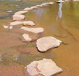
Stepping stones or stepstones are sets of stones arranged to form an improvised causeway that allows a pedestrian to cross a natural watercourse such as a river; or a water feature in a garden where water is allowed to flow between stone steps. Unlike bridges, stepstone crossings typically have no spans, although wood planks or stone slabs can be placed over between the stones to improvise as low-water bridges. Although their historical origin is unknown, stepping stones, along with log bridges, are likely to have been one of the earliest forms of crossing inland bodies of water devised by humans.

<span class="mw-page-title-main">Stanecastle</span> Tower in Stanecastle, Irvine

Stanecastle was a medieval barony and estate in North Ayrshire, Scotland, first mentioned in 1363 and now part of the Irvine New Town project. Its nearest neighbours are Bourtreehill and Girdle Toll.

<span class="mw-page-title-main">Kilwinning Abbey</span> Monastery in North Ayrshire, Scotland, UK

Kilwinning Abbey is a ruined abbey located in the centre of the town of Kilwinning, North Ayrshire.

<span class="mw-page-title-main">Eglinton Castle</span> Gothic castellated mansion in Kilwinning, Scotland

Eglinton Castle was a large Gothic castellated mansion in Kilwinning, North Ayrshire, Scotland.

Girdle Toll is an area of Irvine, North Ayrshire.

<span class="mw-page-title-main">Eglinton Country Park</span>

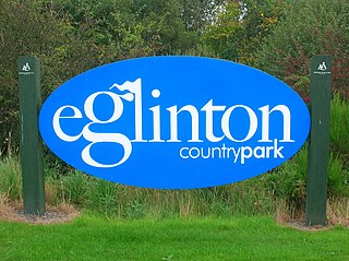
Eglinton Country Park is located on the grounds of the old Eglinton Castle estate in Kilwinning, North Ayrshire, Scotland. Eglinton Park is situated in the parish of Kilwinning, part of the former district of Cunninghame, and covers an area of 400 ha ([98 acres ] of which are woodland. The central iconic feature of the country park is the ruined Eglinton Castle, once home to the Eglinton family and later the Montgomeries, Earls of Eglinton and chiefs of the Clan Montgomery. Eglinton Country Park is managed and maintained by North Ayrshire Council and its Ranger Service.

Riccarton is a village and parish in East Ayrshire, Scotland. It lies across the River Irvine from Kilmarnock, this river forming the boundary between Riccarton and Kilmarnock parishes, and also between the historical districts of Kyle and Cunningham. The name is a corruption of 'Richard's town', traditionally said to refer to Richard Wallace, the uncle of Sir William Wallace. The parish also contains the village of Hurlford.

Benslie is a small village in North Ayrshire, in the parish of Kilwinning, Scotland. Map reference NS 336 429.

<span class="mw-page-title-main">Clonbeith Castle</span>

The Castle of Clonbeith is in the old feudal Baillerie of Cunninghame, near Auchentiber, on a sideroad off the B778, in what is now North Ayrshire, Scotland.

<span class="mw-page-title-main">Robert Burns and the Eglinton Estate</span>

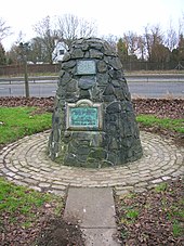
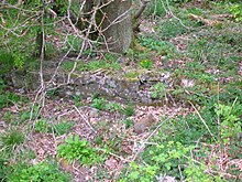
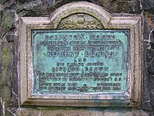
During the years 1781–1782, at the age of 23, Robert Burns (1759–1796) lived in Irvine, North Ayrshire for a period of around 9 months, whilst learning the craft of flax-dressing from Alexander Peacock, who may have been his mother's half-brother, working at the heckling shop in the Glasgow Vennel. Dr John Cumming of Milgarholm, a provost of Irvine, claimed that he had invited Burns to come to Irvine to learn flax dressing. During this time he made a number of acquaintances, befriended several locals and took regular walks into the Eglinton Woods via the old Irvine to Kilwinning toll road and the Drukken or Drucken (Drunken) Steps. Steps over the Red Burn and back via the site of Saint Brides or Bryde's Well at Stanecastle. Burns had several other connections with the Eglinton Estate and other branches of the Montgomerie family. He probably left in March 1782.

<span class="mw-page-title-main">Crosbie Castle and the Fullarton estate</span>

Crosbie Castle and the Fullarton estate lie near Troon in South Ayrshire. The site was the home of the Fullarton family for several centuries. The lands were part of the feudal Barony of Corsbie Fullartoune (sic). The Crosbie Castle ruins were eventually used as an ice house after the new Fullarton House mansion was built. The mansion house was later demolished and the area set aside as a public park and golf course.

<span class="mw-page-title-main">Industry and the Eglinton Castle estate</span>

The Eglinton Castle estate was situated at Irvine, on the outskirts of Kilwinning, North Ayrshire, Scotland in the former district of Cunninghame. Eglinton Castle, was once home to the Montgomeries, Earls of Eglinton and chiefs of the Clan Montgomery. Eglinton Country Park now occupies part of the site.

<span class="mw-page-title-main">Castle and Barony of Robertland</span>

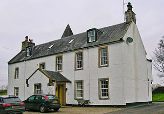
The Castle and Barony of Robertland is located near Stewarton, off the B769 road, in the old district of Cunninghame, Parish of Stewarton, and now part of East Ayrshire, Scotland.

<span class="mw-page-title-main">Seagate Castle</span>

Seagate Castle is a castle in North Ayrshire, in the town of Irvine, close to the River Irvine, Scotland. The castle was formerly a stronghold, a town house, and later a dower house of the Montgomery Clan. The castle overlooks the oldest street in Irvine, which was once the main route between the town and the old harbour at Seagatefoot, which by 1606, was useless and abandoned due to silting. The remains of the castle are protected as a scheduled ancient monument.

<span class="mw-page-title-main">Monkredding House, North Ayrshire</span>

Monkredding formed a small estate in the Parish of Kilwinning, North Ayrshire lying between Kilwinning and Auchentiber on the B778. The property was originally held by the Tironensian monks of Kilwinning Abbey and was the 'Monk's Garden', the rest home for the brothers. Monkcastle near Dalgarven was the abbot's country retreat. Monkredding remains in good condition and is in use as a private house in 2010.

<span class="mw-page-title-main">Richard Brown (captain)</span>

Richard Brown or Ritchie Broun in Scots was born in Irvine. He was a sea captain and a one time friend of Robert Burns who is credited by Burns as the being the person who "encouraged me to endeavour at the character of a Poet."

<span class="mw-page-title-main">Lylestone</span> Human settlement in Scotland

Lylestone is a hamlet in North Ayrshire, Parish of Kilwinning, Scotland. The habitation is situated between Kilwinning and Auchentiber on the B778. It was originally built as a row of housing for quarry workers.

<span class="mw-page-title-main">The Chapel Well</span>

The Chapel Well, sometimes known as Saint Mary's Well or probably erroneously as 'Saint Inan's Well' is located beside the River Irvine at the end of the Chapel Lane path that links to the Kirk Vennel in Irvine, North Ayrshire., Scotland.

<span class="mw-page-title-main">Lawthorn</span> Human settlement in Scotland

Lawthorn is a hamlet near Perceton in Strathannick, Irvine, North Ayrshire, Scotland. The settlement lies on the old Irvine to Stewarton toll road.

References

Notes
  1. McClure, page 61
  2. 1 2 3 4 5 6 Strawhorn, page 31
  3. Love, page 60.
  4. 1 2 3 Strawhorn, Page 95
  5. McJannet, Page 231
  6. Scotch Drink
  7. 1 2 3 Strawhorn, Page 74
  8. 1 2 Strawhorn, Page 223
  9. 1 2 Scots Dictionary Archived 20 February 2008 at the Wayback Machine
  10. Strawhorn, Page 191
  11. 1 2 McLure, page 53.
  12. Irvine Herald.
  13. Scots Dictionary
  14. Strawhorn, Map C6
  15. Muniments,Page 188
  16. Hall, Page 51
  17. Online Dictionary.
  18. Eglinton Archive, Eglinton Country Park
  19. Muniment, Page 188
  20. 1 2 Strawhorn, Page 125
  21. Strawhorn, Page 58
  22. Dougall, page 232.
  23. Douglas, page 24.
  24. Boyle, page 48.
  25. 1 2 Kilwinning 2000, page 36.
  26. Burns Letters 1787
  27. McJannet, page 11 and page 67.
  28. Ordnance Survey.
Bibliography and Sources
  1. Aikman, James (1839). An Account of the Tournament at Eglinton. Edinburgh : Hugh Paton, Carver and Guilder.
  2. Boyle, A. M. (1996), The Ayrshire Book of Burns-Lore. Darvel : Alloway Publishing. ISBN   0-907526-71-3.
  3. Burns, Robert (1787). Poems Chiefly in the Scottish Dialect. Edinburgh : William Creech.
  4. Chambers, Robert, Editor (1891). The Life and Works of Robert Burns. Edinburgh : W & R Chambers.
  5. Dougall, Charles E. (1911). The Burns Country. London : Adam and Charles Black.
  6. Douglas, Hugh (1968). Portrait of the Burns Country (and Galloway). London : Robin Hale. ISBN   0-7091-0113-9.
  7. Eglinton Archive, Eglinton Country Park.
  8. Hall, Derek (2006). Scottish Monastic Landscapes. Tempus Publishing. ISBN   0-7524-4012-8.
  9. Harvey, William, Picturesque Ayrshire. Dundee : Valentine & Sons.
  10. Hill, Rev John C. (1933). The Life and Work of Robert Burns in Irvine. London : Lincoln Williams.
  11. Hogg, Patrick Scott (2008). Robert Burns. The Patriot Bard. Edinburgh : Mainstream Publishing. ISBN   978-1-84596-412-2.
  12. Kilwinning 2000, Millennium Souvenir Programme. Rotary & North Ayrshire Council.
  13. Love, Dane (2003), Ayrshire : Discovering a County. Ayr : Fort Publishing. ISBN   0-9544461-1-9.
  14. Mackay, James. A Biography of Robert Burns. Edinburgh : Mainstream Publishing. ISBN   1-85158-462-5.
  15. McJannet, Arnold F. (1938). The Royal Burgh of Irvine. Glasgow : Civil Press.
  16. McLure, David (1994), Tolls and Tacksmen. 18th century Roads in the County of John Loudoun McAdam. Ayrshire Monographs No. 13. Ayr Arch & Nat Hist Soc. ISBN   0-9502698-5-9.
  17. McQueen, Colin Hunter (1999). Rantin, Rovin Robin. Irvine : Irvine Burns Club and Ayrshire Association. ISBN   1-899316-41-8.
  18. Muniments of the Royal Burgh of Irvine. Ayrshire & Galloway Archaeological Association. 1891.
  19. Ordnance Survey sheet 3240, 1966, 1 : 2500.
  20. Rackham, Oliver (1994). The Illustrated History of the Countryside. London : BCA.
  21. Ross, J. D. (1927). Who's Who in Burns. Stirling : Eneas Mackay.
  22. Service, John (1913), The Memorables of Robin Cummell Paisley : Alexander Gardner.
  23. Strawhorn, John (1985). The History of Irvine. Edinburgh : John Donald. ISBN   0-85976-140-1.
  24. Wilson, Professor and Chalmers, Robert (1840), The Land of Burns. Glasgow : Blackie & Son.