
A ZIP Code is a system of postal codes used by the United States Postal Service (USPS). The term ZIP was chosen to suggest that the mail travels more efficiently and quickly when senders use the code in the postal address.

Middleton Township is one of the nineteen townships of Wood County, Ohio, United States. The 2020 census found 5,611 people in the township.
Jacksontown is a census-designated place (CDP) in central Licking Township, Licking County, Ohio, United States. It has a post office with the ZIP code 43030. It lies at the intersection of U.S. Route 40 with State Route 13.

Buford is an unincorporated community and census-designated place in central Clay Township, Highland County, Ohio, United States. The population was 306 at the 2020 census. It once had a post office, with the ZIP code 45110. The current ZIP code 45171 is for nearby Sardinia.

Lafferty is a census-designated place in northeastern Union Township, Belmont County, Ohio, United States, along Wheeling Creek. As of the 2020 census it had a population of 255. It has a post office with the ZIP code 43951.
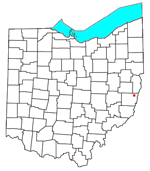
Glencoe is a census-designated place in southern Richland Township, Belmont County, Ohio, United States. As of the 2020 census it had a population of 264. It has a post office with the ZIP code 43928.
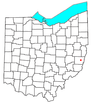
Barton is an unincorporated community in southern Colerain Township, Belmont County, Ohio, United States, along Wheeling Creek. It has a post office with the ZIP code 43905.

North Lima is an unincorporated community and census-designated place in eastern Beaver Township, Mahoning County, Ohio, United States. The population was 1,369 at the 2020 census. Located at the intersection of State Routes 7, 164, and 165, it is part of the Youngstown–Warren metropolitan area.

Ellsworth is an unincorporated community in central Ellsworth Township, Ohio, United States. It is part of the Youngstown–Warren metropolitan area. It lies at the intersection of U.S. Route 224 and State Route 45, and has a post office with the ZIP code 44416.

Damascus is an unincorporated community and census-designated place in southern Mahoning and northern Columbiana counties in the U.S. state of Ohio. As of the 2020 census, it had a population of 418. The community lies at the intersection of U.S. Route 62 and State Routes 173 and 534.

Miamitown is a census-designated place (CDP) in western Whitewater Township, Hamilton County, Ohio, United States. The population was 1,256 at the 2020 census. It has a post office with the ZIP code 45041.

Williamsfield is an unincorporated community in central Williamsfield Township, Ashtabula County, Ohio, United States. It has a post office with the ZIP code 44093. It lies at the intersection of U.S. Route 322 with State Route 7. In 2014, it was named the most stressed community in the United States.

Southington is an unincorporated community in central Southington Township, Trumbull County, Ohio, United States. It lies at the intersection of U.S. Route 422 with State Route 305 and has a post office with the ZIP code 44470. It is part of the Youngstown–Warren metropolitan area.

Kinsman is an unincorporated community and census-designated place in Kinsman Township, Trumbull County, Ohio, United States. The population was 574 at the 2020 census. It is part of the Youngstown–Warren metropolitan area. It lies at the intersection of State Route 5 and State Route 7 between Williamsfield and Burghill. Kinsman has a post office with the ZIP code 44428; as well as a library, the Kinsman Free Public Library.

Fowler is an unincorporated community in central Fowler Township, Trumbull County, Ohio, United States. It has a post office with the ZIP code 44418. It lies at the intersection of State Routes 193 and 305.

East Fultonham is a census-designated place in central Newton Township, Muskingum County, Ohio, United States. It has a post office with the ZIP code 43735. It is located along U.S. Route 22 a short distance east of the village of Fultonham. The population was 290 at the 2020 census.
Olivia is an unincorporated community centered in the Barbecue Township of Harnett County, North Carolina, United States, but also covering parts of Anderson Creek Township near the Lee County line. It is a part of the Dunn Micropolitan Area, which is also a part of the greater Raleigh–Durham–Cary Combined Statistical Area (CSA) as defined by the United States Census Bureau.
West Columbia is an unincorporated community in Mason County, West Virginia, United States. West Columbia is located on the Ohio River and West Virginia Route 62, 3 miles (4.8 km) southwest of Mason. West Columbia has a post office with ZIP code 25287.

Conotton is an unincorporated community in North Township, Harrison County, Ohio, United States. The community is serviced by the Bowerston post office, ZIP Code 44695. It is located near Conotton Creek, State Route 151 and the Wheeling and Lake Erie Railway. According to the GNIS the community has also been known as Masterville.
Dunbar is an unincorporated community in Butler County, Kentucky, United States.


