West Millgrove, Ohio

Last updated

West Millgrove, Ohio
West Millgrove southern houses.jpg
Houses on State Route 199
OHMap-doton-West Millgrove.png
Location of West Millgrove, Ohio
Map of Wood County Ohio Highlighting West Millgrove Village.png
Location of West Millgrove in Wood County
Coordinates: 41°14′34″N83°29′29″W / 41.24278°N 83.49139°W / 41.24278; -83.49139
Country United States
State Ohio
County Wood
Township Perry
Area
[1]
  Total0.26 sq mi (0.67 km2)
  Land0.26 sq mi (0.67 km2)
  Water0.00 sq mi (0.00 km2)
Elevation
[2]
712 ft (217 m)
Population
 (2020)
  Total131
  Density503.85/sq mi (194.55/km2)
Time zone UTC-5 (Eastern (EST))
  Summer (DST) UTC-4 (EDT)
ZIP code
43467
Area code 419
FIPS code 39-83888
GNIS feature ID2400139 [2]

West Millgrove is a village in Wood County, Ohio, United States. The population was 131 at the 2020 census.

Contents

History

West Millgrove was originally called Millgrove, and under the latter name was platted in 1835. [3] A post office called West Mill Grove was established in 1837, and the spelling was changed to West Millgrove in 1895. [4] The village was incorporated in 1874. [5]

Geography

According to the United States Census Bureau, the village has a total area of 0.26 square miles (0.67 km2), all land. [6]

Demographics

Historical population
CensusPop.Note
1880 222
1890 207−6.8%
1900 23614.0%
1910 191−19.1%
1920 132−30.9%
1930 15819.7%
1940 19724.7%
1950 180−8.6%
1960 1968.9%
1970 2159.7%
1980 205−4.7%
1990 171−16.6%
2000 78−54.4%
2010 174123.1%
2020 131−24.7%
U.S. Decennial Census [7]

2010 census

As of the census [8] of 2010, there were 174 people, 64 households, and 43 families living in the village. The population density was 669.2 inhabitants per square mile (258.4/km2). There were 70 housing units at an average density of 269.2 per square mile (103.9/km2). The racial makeup of the village was 96.0% White, 0.6% from other races, and 3.4% from two or more races. Hispanic or Latino of any race were 1.7% of the population.

There were 64 households, of which 37.5% had children under the age of 18 living with them, 35.9% were married couples living together, 23.4% had a female householder with no husband present, 7.8% had a male householder with no wife present, and 32.8% were non-families. 31.3% of all households were made up of individuals, and 12.5% had someone living alone who was 65 years of age or older. The average household size was 2.72 and the average family size was 3.37.

The median age in the village was 32 years. 31% of residents were under the age of 18; 9.2% were between the ages of 18 and 24; 25.3% were from 25 to 44; 24.6% were from 45 to 64; and 9.8% were 65 years of age or older. The gender makeup of the village was 43.7% male and 56.3% female.

2000 census

As of the census [9] of 2000, there were 78 people, 25 households, and 22 families living in the village. The population density was 300.5 inhabitants per square mile (116.0/km2). There were 28 housing units at an average density of 107.9 per square mile (41.7/km2). The racial makeup of the village was 100.00% White.

There were 25 households, out of which 44.0% had children under the age of 18 living with them, 72.0% were married couples living together, 12.0% had a female householder with no husband present, and 12.0% were non-families. 12.0% of all households were made up of individuals, and 4.0% had someone living alone who was 65 years of age or older. The average household size was 3.12 and the average family size was 3.18.

In the village, the population was spread out, with 35.9% under the age of 18, 5.1% from 18 to 24, 28.2% from 25 to 44, 15.4% from 45 to 64, and 15.4% who were 65 years of age or older. The median age was 31 years. For every 100 females there were 100.0 males. For every 100 females age 18 and over, there were 100.0 males.

The median income for a household in the village was $50,625, and the median income for a family was $51,875. Males had a median income of $41,250 versus $28,750 for females. The per capita income for the village was $12,578. There were 4.5% of families and 10.1% of the population living below the poverty line, including 2.6% of under eighteens and none of those over 64.

Related Research Articles

Bradley is a town in Penobscot County, Maine, United States. It is part of the Bangor Metropolitan Statistical Area. The population was 1,532 at the 2020 census. The village of Bradley is in the northwestern corner of the town.

<span class="mw-page-title-main">Mackenzie, Missouri</span> Village in Missouri, United States

Mackenzie is an unincorporated community in St. Louis County, Missouri, United States. The population was 134 at the 2010 census.

<span class="mw-page-title-main">Norwood Court, Missouri</span> Village in Missouri, United States

Norwood Court is a village in St. Louis County, Missouri, United States. The population was 959 at the 2010 census.

<span class="mw-page-title-main">Westwood, Missouri</span> Village in Missouri, United States

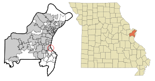
Westwood is a village in west St. Louis County, Missouri, United States. The population was 316 at the 2020 census.

<span class="mw-page-title-main">St. Helena, Nebraska</span> Village in Nebraska, United States

St. Helena is a village in Cedar County, Nebraska, United States. The population was 91 at the 2020 census.

<span class="mw-page-title-main">Chambers, Nebraska</span> Village in Nebraska, United States

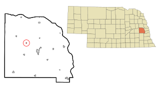
Chambers is a village in Holt County, Nebraska, United States. The population was 268 at the 2010 census.

<span class="mw-page-title-main">Malmo, Nebraska</span> Village in Saunders County, Nebraska, United States

Malmo is a village in Saunders County, Nebraska, United States. The population was 94 at the 2020 census.

<span class="mw-page-title-main">Warsaw, Ohio</span> Village in Ohio, United States

Warsaw is a village in Coshocton County, Ohio, United States, along the Walhonding River. The population was 624 at the 2020 census.

<span class="mw-page-title-main">Brice, Ohio</span> Village in Ohio, United States

Brice is a village in Franklin County, Ohio, United States, on the southeast side of the Columbus metropolitan area. The population was 93 at the 2020 census.

<span class="mw-page-title-main">Metamora, Ohio</span> Village in Ohio, United States

Metamora is a village in Fulton County, Ohio, United States. The population was 566 at the 2020 census.

<span class="mw-page-title-main">Newtown, Ohio</span> Village in Ohio, United States

Newtown is a village in southeastern Hamilton County, Ohio, United States, near Cincinnati. The population was 2,702 at the 2020 census. Newtown was settled in 1792 and incorporated as a village in 1901.

<span class="mw-page-title-main">Sheffield, Ohio</span> Village in Ohio, United States

Sheffield is a village in Lorain County, Ohio, United States, along the Black River. The population was 4,135 at the 2020 census. It is part of the Cleveland metropolitan area.

<span class="mw-page-title-main">Montezuma, Ohio</span> Village in Ohio, United States

Montezuma is a village in Mercer County, Ohio, United States. The population was 152 at the 2020 census.

<span class="mw-page-title-main">Lewisville, Ohio</span> Village in Ohio, United States

Lewisville is a village in Monroe County, Ohio, United States. The population was 184 at the 2020 census.

<span class="mw-page-title-main">Jerry City, Ohio</span> Village in Ohio, United States

Jerry City is a village in Wood County, Ohio, United States. The population was 454 at the 2020 census.

<span class="mw-page-title-main">Browntown, Wisconsin</span> Village in Wisconsin, United States

Browntown is a village in Green County, Wisconsin, United States. The population was 280 at the 2010 census.

<span class="mw-page-title-main">Taylor, Wisconsin</span> Village in Wisconsin, United States

Taylor is a village in Jackson County, Wisconsin, United States, along the Trempealeau River. The population was 484 at the 2020 census.

<span class="mw-page-title-main">South Wayne, Wisconsin</span> Village in Wisconsin, United States

South Wayne is a village in Lafayette County, Wisconsin, United States. The population was 489 at the 2010 census.

<span class="mw-page-title-main">Big Falls, Waupaca County, Wisconsin</span> Village in Wisconsin, United States

Big Falls is a village in Waupaca County, Wisconsin, United States. The population was 61 at the 2010 census.

<span class="mw-page-title-main">Gratiot, Ohio</span> Village in Ohio, United States

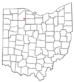
Gratiot is a village in Licking and Muskingum counties in the U.S. state of Ohio. The population was 215 at the 2020 census.

References

  1. "ArcGIS REST Services Directory". United States Census Bureau. Retrieved September 20, 2022.
  2. 1 2 U.S. Geological Survey Geographic Names Information System: West Millgrove, Ohio
  3. Leeson, Michael A. (1897). Commemorative Historical and Biographical Record of Wood County, Ohio: Its Past and Present, Early Settlement and Development. J.H. Beers & Company. p. 353.
  4. "Wood County". Jim Forte Postal History. Retrieved January 11, 2016.
  5. "Cities, Townships, & Villages". Wood County Government. Archived from the original on June 6, 2015. Retrieved January 11, 2016.
  6. "US Gazetteer files 2010". United States Census Bureau . Retrieved January 6, 2013.
  7. "Census of Population and Housing". Census.gov. Retrieved June 4, 2015.
  8. "U.S. Census website". United States Census Bureau . Retrieved January 6, 2013.
  9. "U.S. Census website". United States Census Bureau . Retrieved January 31, 2008.