Portage, Ohio

Last updated

Portage, Ohio
Portage, Ohio viewed from South Dixie Highway-026870.JPG
Portage, Ohio is bisected by State Route 25, sometimes known as South Dixie Highway.
OHMap-doton-Portage.png
Location of Portage, Ohio
Map of Wood County Ohio Highlighting Portage Village.png
Location of Portage in Wood County
Coordinates: 41°19′24″N83°38′48″W / 41.32333°N 83.64667°W / 41.32333; -83.64667
Country United States
State Ohio
County Wood
Government
  MayorWilliam Mark Wolford [1]
Area
[2]
  Total1.49 sq mi (3.85 km2)
  Land1.49 sq mi (3.85 km2)
  Water0.00 sq mi (0.00 km2)
Elevation
[3]
679 ft (207 m)
Population
 (2020)
  Total398
  Density267.47/sq mi (103.28/km2)
Time zone UTC-5 (Eastern (EST))
  Summer (DST) UTC-4 (EDT)
ZIP code
43451
Area code 419
FIPS code 39-64108 [4]
GNIS feature ID2399008 [3]

Portage is a village in Wood County, Ohio, United States. The population was 398 at the 2020 census.

Contents

History

Portage was platted in 1836. [5] The village takes its name from the nearby Portage River. [6] A post office called Portage has been in operation since 1829. [7] Portage was incorporated as a village in 1857. [8]

Geography

According to the United States Census Bureau, the village has a total area of 1.49 square miles (3.86 km2), all land. [9]

Portage is connected to Bowling Green and North Baltimore by the Slippery Elm Trail.

Demographics

Historical population
CensusPop.Note
1880 304
1890 43844.1%
1900 54624.7%
1910 450−17.6%
1920 408−9.3%
1930 4325.9%
1940 408−5.6%
1950 4377.1%
1960 420−3.9%
1970 49417.6%
1980 479−3.0%
1990 469−2.1%
2000 428−8.7%
2010 4382.3%
2020 398−9.1%
U.S. Decennial Census [10]

2010 census

As of the census [11] of 2010, there were 438 people, 164 households, and 105 families living in the village. The population density was 294.0 inhabitants per square mile (113.5/km2). There were 174 housing units at an average density of 116.8 per square mile (45.1/km2). The racial makeup of the village was 94.1% White, 1.4% African American, 0.5% Native American, 0.5% Pacific Islander, 3.0% from other races, and 0.7% from two or more races. Hispanic or Latino of any race were 7.8% of the population.

There were 164 households, of which 30.5% had children under the age of 18 living with them, 51.2% were married couples living together, 8.5% had a female householder with no husband present, 4.3% had a male householder with no wife present, and 36.0% were non-families. 27.4% of all households were made up of individuals, and 7.9% had someone living alone who was 65 years of age or older. The average household size was 2.50 and the average family size was 3.06.

The median age in the village was 38 years. 20.5% of residents were under the age of 18; 9.7% were between the ages of 18 and 24; 27.9% were from 25 to 44; 33.1% were from 45 to 64; and 8.9% were 65 years of age or older. The gender makeup of the village was 49.8% male and 50.2% female.

2000 census

As of the census [4] of 2000, there were 428 people, 153 households, and 108 families living in the village. The population density was 286.0 inhabitants per square mile (110.4/km2). There were 166 housing units at an average density of 110.9 per square mile (42.8/km2). The racial makeup of the village was 91.59% White, 1.17% African American, 0.70% Native American, 3.74% from other races, and 2.80% from two or more races. Hispanic or Latino of any race were 9.81% of the population.

There were 153 households, out of which 35.3% had children under the age of 18 living with them, 62.1% were married couples living together, 7.2% had a female householder with no husband present, and 28.8% were non-families. 22.9% of all households were made up of individuals, and 7.2% had someone living alone who was 65 years of age or older. The average household size was 2.63 and the average family size was 3.12.

In the village, the population was spread out, with 25.9% under the age of 18, 8.2% from 18 to 24, 34.1% from 25 to 44, 22.4% from 45 to 64, and 9.3% who were 65 years of age or older. The median age was 38 years. For every 100 females there were 106.8 males. For every 100 females age 18 and over, there were 105.8 males.

The median income for a household in the village was $37,031, and the median income for a family was $43,125. Males had a median income of $35,227 versus $22,321 for females. The per capita income for the village was $15,698. About 3.9% of families and 10.4% of the population were below the poverty line, including 5.5% of those under age 18 and none of those age 65 or over.

Notable people

Related Research Articles

<span class="mw-page-title-main">Portage Lake, Maine</span> Town in the state of Maine, United States

Portage Lake is a town in Aroostook County, Maine, United States. The population was 359 at the 2020 census.

<span class="mw-page-title-main">Onekama, Michigan</span> Village in Michigan, United States

Onekama is a village in Manistee County in the U.S. state of Michigan. The population was 399 at the 2020 census. The village is located on the northeast shore of Portage Lake and is surrounded by Onekama Township. The town's name is derived from Ona-ga-maa, an Anishinaabe word which means "singing water".

<span class="mw-page-title-main">Aberdeen, Ohio</span> Village in Ohio, United States

Aberdeen is a village in Huntington Township, Brown County, Ohio, United States, along the Ohio River 50 miles (80 km) southeast of Cincinnati. The population was 1,515 at the 2020 census.

<span class="mw-page-title-main">Brice, Ohio</span> Village in Ohio, United States

Brice is a village in Franklin County, Ohio, United States, on the southeast side of the Columbus metropolitan area. The population was 93 at the 2020 census.

<span class="mw-page-title-main">Addyston, Ohio</span> Village in Ohio, United States

Addyston is a village in Miami Township, Hamilton County, Ohio, United States. Located along the Ohio River, it is a western suburb of the neighboring city of Cincinnati. The population was 927 at the 2020 census.

<span class="mw-page-title-main">Cleves, Ohio</span> City in Ohio, United States

Cleves is a village in Miami Township, Hamilton County, Ohio, United States. Located along the Ohio River, it is a western suburb of Cincinnati. The population was 3,414 at the 2020 census.

<span class="mw-page-title-main">Hanover, Ohio</span> Village in Ohio, United States

Hanover is a village in Licking County, Ohio, United States. The population was 1,270 at the 2020 census. The village lies along Ohio State Route 16.

<span class="mw-page-title-main">Sparta, Ohio</span> Village in Ohio, United States

Sparta is a village in Morrow County, Ohio, United States. The population was 121 at the 2020 census. Sparta is southeast of Mount Gilead, the county seat.

<span class="mw-page-title-main">Garrettsville, Ohio</span> Village in Ohio, United States

Garrettsville is a village in northeastern Portage County, Ohio, United States. The population was 2,449 at the 2020 census. It is part of the Akron metropolitan area. The village was formed from portions of Hiram, Nelson, Freedom, and Windham townships in the Connecticut Western Reserve.

<span class="mw-page-title-main">Hiram, Ohio</span> Village in Ohio, United States

Hiram is a village in northern Portage County, Ohio, United States. It was formed from portions of Hiram Township in the Connecticut Western Reserve. The population was 996 at the 2020 census. Hiram is part of the Akron metropolitan area. It is the home of Hiram College, a small, private liberal arts college.

<span class="mw-page-title-main">Mantua, Ohio</span> Village in Ohio, United States

Mantua is a village in northern Portage County, Ohio, United States, along the Cuyahoga River. The population was 1,001 at the time of the 2020 census. It is part of the Akron metropolitan area. It was formed from portions of Mantua Township in the Connecticut Western Reserve.

<span class="mw-page-title-main">Sugar Bush Knolls, Ohio</span> Village in Ohio, United States

Sugar Bush Knolls is a village in western Portage County, Ohio, United States. The population was 217 at the 2020 census. It was formed from portions of Streetsboro and Franklin townships in 1964. The community has the highest median household income in the Akron metropolitan area.

<span class="mw-page-title-main">New Franklin, Ohio</span> City in Ohio, United States

New Franklin is a city in southwestern Summit County, Ohio, United States, in the northeastern part of the state. The population was 13,877 according to the 2020 census. It is part of the Akron metropolitan area.

<span class="mw-page-title-main">Portage Lakes, Ohio</span> Census-designated place in Ohio, United States

Portage Lakes is a census-designated place in Summit County, Ohio, United States. The population was 6,407 at the 2020 census. A suburb directly south of Akron, the community takes its name from the encompassing Portage Lakes.

<span class="mw-page-title-main">Port Washington, Ohio</span> Village in Ohio, United States

Port Washington is a village in Tuscarawas County, Ohio, United States. The population was 548 at the 2020 census.

<span class="mw-page-title-main">Nelsonville, Wisconsin</span> Village in Wisconsin, United States

Nelsonville is a village in Portage County, Wisconsin, United States. The population was 155 at the 2010 census.

<span class="mw-page-title-main">Whiting, Wisconsin</span> Village in Wisconsin, United States

Whiting is a village in Portage County, Wisconsin, United States and is a suburb of Stevens Point. It is included in the Stevens Point Micropolitan Statistical Area. The population was 1,601 at the 2020 census.

<span class="mw-page-title-main">Gratiot, Ohio</span> Village in Ohio, United States

Gratiot is a village in Licking and Muskingum counties in the U.S. state of Ohio. The population was 215 at the 2020 census.

<span class="mw-page-title-main">Elmore, Ohio</span> Village in Ohio, United States

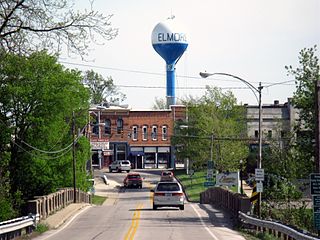
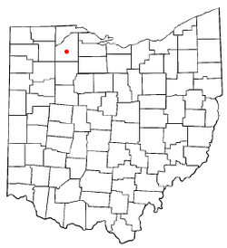
Elmore is a village in Ottawa and Sandusky counties in the U.S. state of Ohio. The population was 1,370 at the 2020 census.

<span class="mw-page-title-main">Mogadore, Ohio</span> Village in Ohio, United States

Mogadore is a village in Portage and Summit counties in the U.S. state of Ohio. The population was 3,811 at the 2020 census. A suburb of Akron, it is part of the Akron metropolitan area.

References

  1. "Office Holder Details" (PDF). Archived from the original (PDF) on June 24, 2016. Retrieved June 7, 2016.
  2. "ArcGIS REST Services Directory". United States Census Bureau. Retrieved September 20, 2022.
  3. 1 2 U.S. Geological Survey Geographic Names Information System: Portage, Ohio
  4. 1 2 "U.S. Census website". United States Census Bureau . Retrieved January 31, 2008.
  5. Leeson, Michael A. (1897). Commemorative Historical and Biographical Record of Wood County, Ohio: Its Past and Present, Early Settlement and Development. J.H. Beers & Company. p. 393.
  6. Overman, William Daniel (1958). Ohio Town Names. Akron, OH: Atlantic Press. p. 113.
  7. "Wood County". Jim Forte Postal History. Retrieved January 11, 2016.
  8. "Cities, Townships, & Villages". Wood County Government. Archived from the original on June 6, 2015. Retrieved January 11, 2016.
  9. "US Gazetteer files 2010". United States Census Bureau. Archived from the original on July 2, 2012. Retrieved January 6, 2013.
  10. "Census of Population and Housing". Census.gov. Retrieved June 4, 2015.
  11. "U.S. Census website". United States Census Bureau . Retrieved January 6, 2013.