East Keansburg, New Jersey

Last updated
East Keansburg, New Jersey
Unincorporated community
Location map of Monmouth County, New Jersey.svg
Red pog.svg
East Keansburg, New Jersey
Location of East Keansburg in Monmouth County Inset: Location of county within the state of New Jersey
USA New Jersey location map.svg
Red pog.svg
East Keansburg, New Jersey
East Keansburg, New Jersey (New Jersey)
Usa edcp location map.svg
Red pog.svg
East Keansburg, New Jersey
East Keansburg, New Jersey (the US)
Coordinates: 40°26′20″N74°07′01″W / 40.43889°N 74.11694°W / 40.43889; -74.11694 Coordinates: 40°26′20″N74°07′01″W / 40.43889°N 74.11694°W / 40.43889; -74.11694
Country Flag of the United States.svg  United States
State Flag of New Jersey.svg  New Jersey
County Monmouth
Township Middletown
Elevation [1] 7 ft (2 m)
GNIS feature ID 882449 [1]

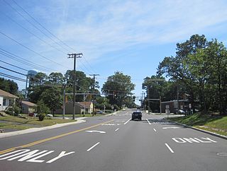
East Keansburg is an unincorporated community located within Middletown Township in Monmouth County, New Jersey, United States. [2] As the name suggests the area is east of Keansburg, NJ with State Route 36 bordering the south, Port Monmouth to the east across Pews Creek, and the Raritan Bay to the north. The community is included in the generalized North Middletown region of the township.

Middletown Township, New Jersey Township in New Jersey, United States

Middletown Township is a township in Monmouth County, New Jersey, United States. As of the 2010 United States Census, the township had a total population of 66,522, making it the state's 16th largest municipality, having seen an increase of 195 residents (0.3%) from its population of 66,327 in the 2000 Census, when it was the state's 17th most populous municipality, which had in turn declined by 1,856 (−2.7%) from the 68,183 counted in the 1990 Census. Middletown is one of the oldest sites of European settlement in New Jersey.

Monmouth County, New Jersey County in the United States

Monmouth County is a county located in Central New Jersey, in the United States within the New York metropolitan area, and the northernmost county along the Jersey Shore. As of the 2017 Census estimate, the county's population was 626,351, making it the state's fifth-most populous county, representing a decrease of 0.6% from the 2010 Census, when the population was enumerated at 630,380, in turn an increase of 15,079 from 615,301 at the 2000 Census. As of 2010, the county fell to the fifth-most populous county in the state, having been surpassed by Hudson County. Its county seat is Freehold Borough. The most populous place was Middletown Township, with 66,522 residents at the time of the 2010 Census, while Howell Township covered 61.21 square miles (158.5 km2), the largest total area of any municipality.

New Jersey State of the United States of America

New Jersey is a state in the Mid-Atlantic and Northeastern regions of the United States. It is located on a peninsula, bordered on the north and east by the state of New York, particularly along the extent of the length of New York City on its western edge; on the east, southeast, and south by the Atlantic Ocean; on the west by the Delaware River and Pennsylvania; and on the southwest by the Delaware Bay and Delaware. New Jersey is the fourth-smallest state by area but the 11th-most populous, with 9 million residents as of 2017, and the most densely populated of the 50 U.S. states; its biggest city is Newark. New Jersey lies completely within the combined statistical areas of New York City and Philadelphia and was the second-wealthiest U.S. state by median household income as of 2017.

East Keansburg is surrounded by an earthen levee (known as "the dike") constructed as protection against flooding, during large storms such as Hurricane Sandy. [3]

Levee Ridge or wall to hold back water

A levee, dike, dyke, embankment, floodbank or stopbank is an elongated naturally occurring ridge or artificially constructed fill or wall, which regulates water levels. It is usually earthen and often parallel to the course of a river in its floodplain or along low-lying coastlines.

Hurricane Sandy Category 3 Atlantic hurricane in 2012

Hurricane Sandy was the deadliest and most destructive hurricane of the 2012 Atlantic hurricane season. Inflicting nearly $70 billion in damage, it was the second-costliest hurricane on record in the United States until surpassed by Hurricanes Harvey and Maria in 2017. The eighteenth named storm, tenth hurricane, and second major hurricane of the year, Sandy was a Category 3 storm at its peak intensity when it made landfall in Cuba. While it was a Category 2 hurricane off the coast of the Northeastern United States, the storm became the largest Atlantic hurricane on record. At least 233 people were killed along the path of the storm in eight countries.

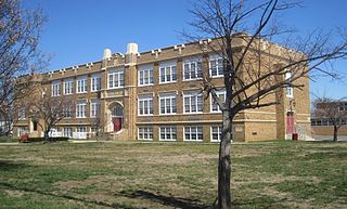
The community includes the Tonya Keller Community Center, McMahon Park, and Ideal Beach along the bay. East Keansburg Fire Company #1 and Middletown Township First Aid & Rescue Squad are both located in East Keansburg. Portions of the Keansburg High School grounds are in Middletown/East Keansburg.

Keansburg High School

Keansburg High School is a four-year comprehensive community public high school serving students in ninth through twelfth grades from Keansburg, Monmouth County, New Jersey, United States, operating as the lone high school of the Keansburg School District. The school is a candidate for accreditation by the Middle States Association of Colleges and Schools Commission on Secondary Schools.

Related Research Articles

New Jersey Route 35 highway in New Jersey

Route 35 is a state highway in the U.S. state of New Jersey, primarily traveling through the easternmost parts of Middlesex, Monmouth, and Ocean counties. It runs 58.11 mi (93.52 km) from the entrance to Island Beach State Park in Berkeley Township, Ocean County to an intersection with Route 27 in Rahway, Union County. Between Seaside Park and Mantoloking, Route 35 follows the right-of-way of the former Pennsylvania Railroad along the Jersey Shore. The route heads through Point Pleasant Beach and crosses the Manasquan River on the Brielle Bridge, meeting Route 34 and Route 70 at the former Brielle Circle in Wall Township. From there, Route 35 heads north and intersects Route 138, an extension of Interstate 195, continuing north through Monmouth County before crossing the Victory Bridge over the Raritan River into Perth Amboy, where the route continues north to Rahway.

New Jersey Route 36 highway in New Jersey

Route 36 is a state highway in Monmouth County, New Jersey, United States. The 24.40-mile (39.27 km) long route, shaped as a backwards C, begins at an intersection with Garden State Parkway and County Route 51 in Eatontown and runs east to Long Branch. From Long Branch, the route follows the Atlantic Ocean north to Sea Bright and turns west, running to the south of the Raritan Bay. Route 36 ends in Keyport at an interchange with the Garden State Parkway and Route 35. It varies in width from a six-lane divided highway to a two-lane undivided road. The route is signed east–west between Eatontown and Long Branch and north–south between Long Branch and Keyport.

Aberdeen Township, New Jersey Township in New Jersey

Aberdeen Township is a township in Monmouth County, New Jersey, United States. As of the 2010 United States Census, the township's population was 18,210, reflecting an increase of 756 (+4.3%) from the 17,454 counted in the 2000 Census, which had in turn increased by 416 (+2.4%) from the 17,038 counted in the 1990 Census.

Cliffwood Beach, New Jersey Census-designated place in New Jersey, United States

Cliffwood Beach is an unincorporated community and census-designated place (CDP) located within Aberdeen Township, in Monmouth County, New Jersey, United States. As of the 2010 United States Census, the CDP's population was 17,011. As of the 2010 United States Census, the CDP's population was 3,194.

Hazlet, New Jersey Township in New Jersey, United States

Hazlet is a township in Monmouth County, New Jersey, United States. As of the 2010 United States Census, the township's population was 20,334, reflecting a decline of 1,044 (-4.9%) from the 21,378 counted in the 2000 Census, which had in turn declined by 598 (-2.7%) from the 21,976 counted in the 1990 Census.

Highlands, New Jersey Borough in New Jersey, United States

Highlands is a borough in Monmouth County, New Jersey, United States. As of the 2010 United States Census, the borough's population was 5,005, reflecting a decline of 92 (-1.8%) from the 5,097 counted in the 2000 Census, which had in turn increased by 248 (+5.1%) from the 4,849 counted in the 1990 Census. It is the home town of film maker, director, and comic book writer Kevin Smith. The eastern part of the town is built on a high bluff that overlooks Sandy Hook and the Atlantic Ocean, from which the borough derives its name. Atop this bluff are the Navesink Twin Lights.

Keansburg, New Jersey Borough in New Jersey, United States

Keansburg is a borough in Monmouth County, New Jersey, United States. As of the 2010 United States Census, the borough's population was 10,105, which represented a decline of 627 (-5.8%) from the 10,732 counted in the 2000 Census, which had in turn declined by 337 (-3.0%) from the 11,069 counted in the 1990 Census.

Shrewsbury Township, New Jersey Township in New Jersey, United States

Shrewsbury Township is a township in Monmouth County, New Jersey, United States. As of the 2010 United States Census, the township's population was 1,141, reflecting an increase of 43 (+3.9%) from the 1,098 counted in the 2000 Census, which was unchanged from the 1,098 counted in the 1990 Census.

Union Beach, New Jersey Borough in New Jersey, United States

Union Beach is a borough in Monmouth County, New Jersey, United States. As of the 2010 United States Census, the borough's population was 6,245, reflecting a decline of 404 (-6.1%) from the 6,649 counted in the 2000 Census, which had in turn increased by 493 (+8.0%) from the 6,156 counted in the 1990 Census.

Keyport, New Jersey Borough in New Jersey, United States

Keyport is a borough in Monmouth County, New Jersey, United States. At the 2010 United States Census, the borough's population was 7,240, following a decline of 328 (-4.3%) from the 7,568 counted in the 2000 Census, which had in turn declined by 18 (-0.2%) from the 7,586 counted in the 1990 Census. Keyport's nickname is the "Pearl of the Bayshore" or the "Gateway to the Bayshore".

Atlantic Highlands, New Jersey Borough in New Jersey

Atlantic Highlands is a borough in Monmouth County, New Jersey, in the Bayshore Region. As of the 2010 United States Census, the borough's population was 4,385,, a decline of 320 (-6.8%) from the 4,705 in the 2000 Census, which had in turn increased by 76 (+1.6%) from the 4,629 in the 1990 Census.

Sandy Hook peninsula in New Jersey

Sandy Hook is a barrier spit in Middletown Township, Monmouth County, New Jersey, United States. The barrier spit, approximately 6 miles (9.7 km) in length and varying from 0.1 to 1.0 mile wide, is located at the north end of the Jersey Shore. It encloses the southern entrance of Lower New York Bay south of New York City, protecting it from the open waters of the Atlantic Ocean to the east. The Dutch called the area "Sant Hoek", with the English "Hook" deriving from the Dutch "Hoek", meaning "spit of land".

Jersey Shore coastal region of the U.S. state of New Jersey

The Jersey Shore is the coastal region of the U.S. state of New Jersey. Geographically, the term encompasses about 141 miles (227 km) of oceanfront bordering the Atlantic Ocean, from Perth Amboy in the north to Cape May Point in the south. The region includes Middlesex, Monmouth, Ocean, Atlantic, and Cape May counties. Many New Jersey residents refer to it simply as "The Shore", as in to go or have done something "down the shore". While there is no defined border between North Jersey and South Jersey, the Raritan River, Manasquan River, or I-195 are often mentioned as the border, and as such, most of the shore region is located in South Jersey.

Raritan Bayshore

The Raritan Bayshore region of New Jersey is a subregion of the larger Jersey Shore. It is the area around Raritan Bay from The Amboys to Sandy Hook, in Monmouth and Middlesex counties, including the towns of Perth Amboy, Keyport, "Pearl of the Bayshore", Keansburg, and Highlands, New Jersey. It is the northernmost part of the Jersey Shore, located just south of New York City. At Keansburg is a traditional amusement park while at Sandy Hook are found ocean beaches. The Sadowski Parkway beach area in Perth Amboy, which lies at the mouth of the Raritan River, was deemed the "Riviera of New Jersey" by local government. In the last years many of the beaches on the Bayshore area have been rediscovered and upgraded as the quality of the water continues to improve.

West Keansburg, New Jersey Unincorporated community in New Jersey, United States

West Keansburg is an unincorporated community located within Hazlet Township in Monmouth County, New Jersey, United States. Its total land area is estimated at 1.667 square miles (4.32 km2) and it includes portions of the township east of Waackaack Creek and some parts north of Route 36, as well as some other parts in northeast Hazlet. As of the 2000 United States Census, West Keansburg had a population of 14,423, which is over half of Hazlet's total population of 21,165.

Beacon Hill, New Jersey Unincorporated community in New Jersey, United States

Beacon Hill is an unincorporated community located within Marlboro Township in Monmouth County, New Jersey, United States. The community is named for a nearby hill, in-turn named because it was a lookout point towards the Raritan Bay and beacons on the hill were used to warn residents of impending British troops in the American Revolutionary War. Located on the north face of the hill are housing developments and Marlboro Memorial Middle School. East of the summit, New Jersey Route 34 runs through the area through a commercial zone.

Chapel Hill, New Jersey Unincorporated community in New Jersey, United States

Chapel Hill is an unincorporated community located within Middletown Township, in Monmouth County, New Jersey, United States. As its name implies, the area is on a high spot within the township between Fairview and Leonardo just south of the Naval Weapons Station Earle Waterfront Section. Unlike other areas of Middletown Township, the Chapel Hill section is not as developed with single-family homes; only a few housing developments are located off the area's main roads, Kings Highway and Chapel Hill Road. The rest of the area outside NWS Earle consists of horse farms and forestland.

Tiltons Corner, New Jersey Unincorporated community in New Jersey, United States

Tiltons Corner or Tiltons Corners is an unincorporated community located where the municipal boundaries of Keansburg Borough, Hazlet Township and Middletown Township intersect in Monmouth County, New Jersey, United States.

References

  1. 1 2 "East Keansburg". Geographic Names Information System . United States Geological Survey.
  2. Locality Search, State of New Jersey. Accessed February 23, 2015.
  3. Morang, Andrew. "Hurricane Barriers in New England and New Jersey: History and Status after Five Decades", Journal of Coastal Research, Volume 32, Issue 1. Accessed June 8, 2016. "The U.S. Army Engineer District, New York (NAN), project is in Laurence Harbor (previously named Madison), Keansburg, and North Middletown (previously named East Keansburg) Townships, New Jersey, facing Raritan and Sandy Hook Bays."