Allentown is a borough, located in western Monmouth County, in the U.S. state of New Jersey, bordering nearby Mercer County. As of the 2020 United States census, the borough's population was 1,734, a decrease of 94 (−5.1%) from the 2010 census count of 1,828, which in turn reflected a decline of 54 (−2.9%) from the 1,882 counted in the 2000 census. The borough is nestled within central New Jersey, and is roughly equidistant between New York City and Philadelphia.

Freehold is a borough and the county seat of Monmouth County, in the U.S. state of New Jersey. Known for its Victorian era homes and rich colonial history, the borough is located in the Raritan Valley region within the New York Metropolitan Area, located about 33 miles (53 km) from Manhattan and 17 miles (27 km) from Staten Island. The borough has grown to become a commuter town of New York City. As of the 2020 United States census, the borough's population was 12,538, an increase of 486 (+4.0%) from the 2010 census count of 12,052, which in turn reflected an increase of 1,076 (+9.8%) from the 10,976 counted in the 2000 census.
Millstone Township is a township in western Monmouth County, in the U.S. state of New Jersey. The Township is located within the Raritan Valley region and is a part of the New York metropolitan area. As of the 2020 United States census, the township's population was 10,376, a decrease of 190 (−1.8%) from the 2010 census count of 10,566, which in turn reflected an increase of 1,596 (+17.8%) from the 8,970 counted in the 2000 census.

Upper Freehold Township is a township in Monmouth County, in the U.S. state of New Jersey. As of the 2020 United States census, the township's population was 7,273, an increase of 371 (+5.4%) from the 2010 census count of 6,902, which in turn reflected an increase of 2,620 (+61.2%) from the 4,282 counted in the 2000 census.

Clarksburg is an unincorporated community located within Millstone Township in Monmouth County, in the U.S. state of New Jersey. The area is served as United States Postal Service ZIP code 08510.

Pottersville is an unincorporated community split between Bedminster Township in Somerset County, Tewksbury Township in Hunterdon County and Washington Township in Morris County, New Jersey, United States. The area is served as United States Postal Service ZIP Code 07979. As of the 2010 United States Census, the population for ZIP Code Tabulation Area 07979 was 589. In 1990, most of the village was listed on the National Register of Historic Places as the Pottersville Village Historic District.

The Monmouth County Historical Association was established in 1898 by a group of county residents headed by professional educator Caroline Gallup Reed. They soon incorporated in order “to discover, procure, preserve and perpetuate whatever relates to the history of Monmouth County.” In 1931, the present Museum and Library, a brick Georgian-style building designed by architect J. Hallam Conover, was constructed in Freehold, the county seat of Monmouth County, New Jersey. The enthusiasm generated by the announcement of a new headquarters brought in numerous contributions of furniture, artifacts, paintings, rare documents and books.

St. Peter's Episcopal Church is a historic Episcopal church building at 31 Throckmorton Street in Freehold Borough, Monmouth County, New Jersey, United States.

Upper Freehold Baptist Meeting, also known as Ye Olde Yellow Meeting House, is a historic church located on Yellow Meetinghouse and Red Valley roads in the Red Valley section of Upper Freehold Township near Imlaystown in Monmouth County, New Jersey. It is the oldest Baptist meetinghouse in the state. It was added to the National Register of Historic Places on April 21, 1975 for its significance in religion and exploration/settlement.

Upper Meeting House of the Baptist Church of Middletown is a historic church at 40 Main Street in Holmdel Township, Monmouth County, New Jersey, United States. It was the first Baptist church congregation in New Jersey.
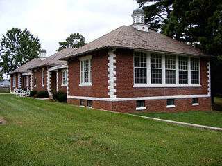
The Court Street School is located in Freehold Borough, Monmouth County, New Jersey, United States. The building was built in 1921 and was added to the National Register of Historic Places on August 4, 1995.

Arneytown is an unincorporated community located along Province Line Road on the border of North Hanover Township in Burlington County and Upper Freehold Township in Monmouth County of New Jersey. It is two miles (3.2 km) north of Jacobstown. Province Line Road was on the boundary line between the Provinces of East Jersey and West Jersey. The area was once called Upper Freehold by 18th-century Quaker settlers. With the establishment of the first post office in 1827, it became known as Arneytown.

Little York is an unincorporated community located along the border of Alexandria and Holland townships in Hunterdon County, New Jersey, United States. Little York is located on County Route 614 3.1 miles (5.0 km) north-northeast of Milford. Little York has a post office with ZIP code 08834.

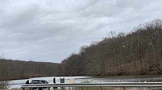
Cooleys Corner is an unincorporated community located within Upper Freehold Township in Monmouth County, New Jersey, United States. The site of the settlement is within the Assunpink Wildlife Management Area, a New Jersey Department of Environmental Protection Division of Fish and Wildlife-operated preserved area in Monmouth and Mercer counties along the Assunpink Creek. Before the creation of the Assunpink Lake in the 1970s, the area consisted of farmland located at the intersection of Clarksburg Road and Imlaystown-Hightstown Road. Some farmland is still present in the area but is now mostly used by hunters. The main boat ramp to Assunpink Lake is located along the former Imlaystown-Hightstown Road.

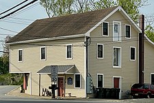
Coxs Corner, also known as Cox's Corner or Wrightsville, is an unincorporated community located within Upper Freehold Township, in Monmouth County, New Jersey, United States. Named for congressman and brigadier general James Cox (1753–1810), who had lived here at the family home of "Box Grove", it is at the juncture of County Route 524 and County Route 43. The Upper Freehold Historic Farmland Byway passes through the area.

Walnford is an unincorporated community located along Crosswicks Creek within Upper Freehold Township in Monmouth County, New Jersey, United States. Walnford was named for Richard Waln, the original owner of the town site.

The Walker, Combs, Hartshorne, Oakley Farmstead is located in the historic district of the village of West Freehold, a part of Freehold Township in Monmouth County, New Jersey, United States. The house was built in 1686 and was added to the National Register of Historic Places on October 14, 1990.

George Taylor House is in Freehold Borough, Monmouth County, New Jersey, United States on the corner of Broadway and Dutch Lane Road across from Freehold High School. The house was built in circa 1870 by George Taylor, the son of John G. Taylor and Cary Conover Taylor. John G. Taylor was of Scottish ancestry, while Cary Conover was of Dutch ancestry. John G. Taylor was the proprietor of Taylors Mills, a successful family business that George continued to run in his father's footsteps. The grist mill was successful during the mid-late 19th century, as new markets were opening up with the advent of extensive railroad networks.

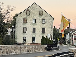
Salter's Mill is a historic gristmill built c. 1897 and located at 33 Imlaystown Road in the Imlaystown section of Upper Freehold Township in Monmouth County, New Jersey. It was added to the National Register of Historic Places on September 29, 1980, for its significance in agriculture, architecture, and exploration/settlement. The mill is next to a 28-acre (11 ha) mill pond, which was also used in the ice business. In 1985, it was also listed as a contributing property of the Imlaystown Historic District.

Franklin Corners is an unincorporated community located along the Passaic River at the intersection of County Route 613 and U.S. Route 202 in Bernards Township of Somerset County, New Jersey. In the 19th century, it had a grist mill, saw mill, general store, school, and several houses. The Franklin Corners Historic District, featuring Van Dorn's Mill, was listed on the National Register of Historic Places in 1975.