
Monmouth County is a county located on the northern part of the Jersey Shore in the U.S. state of New Jersey. The county is part of the New York metropolitan area. As of the 2020 United States census, the county was the state's fifth-most-populous county with a population of 643,615, its highest decennial count ever and an increase of 13,235 (+2.1%) from the 2010 census count of 630,380, which in turn reflected an increase of 15,079 from 615,301 at the 2000 census. As of 2010, the county fell to the fifth-most populous county in the state, having been surpassed by Hudson County. Monmouth County's geographic area comprises 30% water.

Route 36 is a state highway in Monmouth County, New Jersey, United States. The 24.40-mile (39.27 km) long route, shaped as a backwards C, begins at an intersection with the Garden State Parkway and County Route 51 on the border of Tinton Falls and Eatontown and runs east to Long Branch. From Long Branch, the route follows the Atlantic Ocean north to Sea Bright and turns west, running to the south of the Raritan Bay. Route 36 ends in Keyport at an interchange with the Garden State Parkway and Route 35. It varies in width from a six-lane divided highway to a two-lane undivided road. The route is signed east–west between Eatontown and Long Branch and north–south between Long Branch and Keyport.

Middletown Township is a township in Monmouth County, in the U.S. state of New Jersey. As of the 2020 United States census, the township was the state's 20th-most-populous municipality and the largest in the county, with a population of 67,106, an increase of 584 (+0.9%) from the 2010 census count of 66,522, which in turn reflected an increase of 195 residents (0.3%) from its population of 66,327 in the 2000 Census, when it was the state's 17th-most-populous municipality.

Sandy Hook is a barrier spit in Middletown Township, Monmouth County, New Jersey, United States. The barrier spit, approximately 6 miles (9.7 km) in length and varying from 0.1 to 1.0 mile wide, is located at the north end of the Jersey Shore. It encloses the southern entrance of Lower New York Bay south of New York City, protecting it from the open waters of the Atlantic Ocean to the east.

Naval Weapons Station Earle is a United States Navy base in Monmouth County, New Jersey, United States. Its distinguishing feature is a 2.9-mile (4.7 km) pier in Sandy Hook Bay where ammunition can be loaded and unloaded from warships at a safe distance from heavily populated areas.

The Raritan Bayshore is a region in central sections in the state of New Jersey. It is the area around Raritan Bay from The Amboys to Sandy Hook, in Monmouth and Middlesex counties, including the towns of Woodbridge, Perth Amboy, South Amboy, Sayreville, Old Bridge, Matawan, Aberdeen, Keyport, Union Beach, Hazlet, Keansburg, Middletown, Atlantic Highlands, and Highlands. It is the northernmost part of the Jersey Shore, located just south of New York City. At Keansburg is a traditional amusement park while at Sandy Hook are found ocean beaches. The Sadowski Parkway beach area in Perth Amboy, which lies at the mouth of the Raritan River, was deemed the "Riviera of New Jersey" by local government. In recent years many of the beaches on the Bayshore area have been rediscovered and upgraded.

Locust is an unincorporated community located within Middletown Township in Monmouth County, New Jersey, United States. It is situated along the north banks of the Navesink River and Claypit Creek. The area consists of mostly medium-to-large sized houses throughout the hilly terrain of this part of the township. The Oceanic Bridge connects Locust with Rumson to the south.

New Monmouth is an unincorporated community located within Middletown Township in Monmouth County, New Jersey, United States. The area is served as United States Postal Service ZIP code 07748.
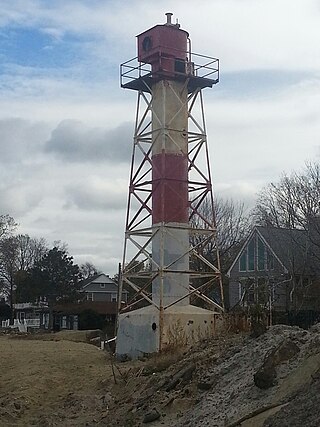
The Conover Beacon is a lighthouse in Leonardo section of Middletown Township, Monmouth County, New Jersey, United States, that functioned as the front light of the now-discontinued Chapel Hill Range.

Fort Hancock and the Sandy Hook Proving Ground Historic District is a National Historic Landmark District that includes Fort Hancock and the Sandy Hook Proving Ground on Sandy Hook in Middletown Township, Monmouth County, New Jersey, United States. The district was added to the National Register of Historic Places on April 24, 1980 and designated a National Historic Landmark on December 17, 1982. It is part of Gateway National Recreation Area, administered by the National Parks of New York Harbor office of the National Park Service.

River Plaza is an unincorporated community located within Middletown Township in Monmouth County, New Jersey, United States. It is adjacent to the Navesink River and Shadow Lake.

Retreat is an unincorporated community and former hamlet located within Southampton Township in Burlington County, New Jersey, United States. The area consists of some residential houses grouped together along Big Hill Road and Retreat Road. A large cranberry bog exists to the southeast of the community while Leisuretowne retirement community is located southwest of here. Most of the remaining area consists of forestland.

Prospertown is an unincorporated community located within the New Jersey townships of Jackson and Plumsted in Ocean County and Upper Freehold in Monmouth County. The community is home to Prospertown Lake and is adjacent to Six Flags Great Adventure, both located on County Route 537. The center of the community is located at the intersection of CR 537, Hawkin Road, and Emleys Hill Road. Most of the area consists of pine forests but there are some homes along the roads in the area.

Emleys Hill is an unincorporated community located within Upper Freehold Township in Monmouth County, New Jersey, United States. The settlement is located at the intersection of Emleys Hill Road and Burlington Path Road.

Hoffman is an unincorporated community located within Monroe Township in Middlesex County, New Jersey, United States. The settlement is located at the site of a former railroad station on the Freehold and Jamesburg Agricultural Railroad. Today, most of the area is made up of homes and housing developments along Hoffman Station Road and Gravel Hill-Spotswood Road. Forestland and the Manalapan Brook valley make up the remainder of the area.

Sandy Ridge is an unincorporated community located within Delaware Township in Hunterdon County, New Jersey, United States. As its name implies, the community is located at the top of a small hill that is sandwiched between the Hunterdon Plateau and the Sourland Mountains. Sandy Ridge Road is the main road east and west through the community while County Route 605 is a minor arterial road that passes north and south through the area. CR 605 enters from the south on Sandy Ridge-Mt. Airy Road, jogs to the west on Sandy Ridge Road for 0.04 miles (64 m), and exits to the north on Cemetery Road towards CR 523. The area consists of mainly residences with some farmland and forestland. The Sandy Ridge Church is a Baptist church founded in 1818 with its current building constructed in 1866 and is located in the center of Sandy Ridge.
East Keansburg is an unincorporated community located within Middletown Township in Monmouth County, New Jersey, United States. As the name suggests, the area is east of Keansburg with Route 36 bordering the south, Port Monmouth to the east across Pews Creek, and the Raritan Bay to the north. The community is included in the generalized North Middletown region of the township.

Oceanic is an unincorporated community located within Rumson in Monmouth County, New Jersey, United States. Located on the north side of the borough, Oceanic contains most of Rumson's commercial businesses mainly along Bingham Avenue and River Road. Bingham Avenue connects directly to the Oceanic Bridge over the Navesink River to the Middletown Township community of Locust Point.


