Elmbank, Ontario

Last updated

Elmbank, Ontario
Ghost town
Deicing Pearson.jpg
Looking north toward the former Hamlet of Elmbank, now occupied by the de-icing facility at Pearson Airport
Coordinates: 43°40′27″N79°37′33″W / 43.67417°N 79.62583°W / 43.67417; -79.62583
CountryCanada
Province Ontario
Regional municipality Peel
City Mississauga
Time zone UTC-5 (EST)
  Summer (DST) UTC-4 (EDT)
NTS Map030M12

Elmbank is a ghost town in Mississauga, Ontario, Canada.

Contents

The hamlet at the intersection of Fifth Line East (now Torbram Road) and Britannia Road was once a thriving 19th century rural community. It was later cleared for expansion of the Toronto Pearson International Airport.

A part of the original Britannia Rd. still exists, now as a street east of the airport named "Elmbank Road". Nothing remains of the former community.

History

1877 Peel Atlas pg20-21 Toronto Township Northern Part PN2019 21632-5.jpg
Map of Toronto Township in Peel County showing Elmbank, 1880

Land in the area was cleared for farming beginning in the mid 1820s.[ citation needed ] The first resident was John Grubb, who emigrated from Scotland in 1831. Grubb built a home overlooking Etobicoke Creek, and named the place Elmbank. [1]

Other settlers followed, and the Elmbank community soon had a blacksmith, store, inn, schoolhouse, cheese factory, carriage maker, and Sons of Temperance Society Hall. No mills were located there. [2]

The Elmbank Post Office operated from 1873 to 1915, and the first postmaster, William McKay, operated out of his store. [2]

Shell's Chapel was built south of the community in 1831, named after Jacob and Henry Shell. The chapel was renamed Bethany Wesleyan Methodist Church and Cemetery, and then Bethany United Church in 1925. The last service was held in 1956, and the graves were relocated to Riverside Cemetery in Etobicoke. [2]

Elmbank was noted for its importance to Toronto's Catholic community. The Catholic Mission and Cemetery, a log church constructed in 1833, was located in Elmbank and parishioners would travel from Toronto for mass or funerals. In 1885, a red brick church and rectory replaced the log church. The last recorded mass took place in 1915, and the church was torn down in 1932. Materials from the church such as pews, bricks and stained glass windows were reused in neighbouring churches. [2] [3]

Residents of Elmbank had a close association with the community of Malton, located a short distance northeast. The Elmbank soccer team, composed of young men from Elmbank and Malton, won the Peel league championship. [2] Residents of Elmbank also participated in Malton's day-long Callithumpian Parade, held annually beginning in 1896. The Sons of Temperance Society Hall was also used occasionally for lectures organized by the Malton Women's Institute, founded in 1906. [1]

Elmbank's population peaked at 300 in 1886, and had declined to about 30 by 1926. [2]

In 1937, the Toronto Harbour Commission selected Malton as the site for Toronto's airport. The rural land near Elmbank was expropriated and its buildings demolished for successive expansions of the airport. By the 1950s, the only visible remnant of the Elmbank community was the Catholic cemetery. [2]

Cemetery relocation

The Catholic cemetery, also called the Elmbank/Fifth Line Cemetery, was used for over 600 burials, the last taking place in 1937. Access to the cemetery was limited after that, as it was located on airport property. [3] [4]

The cemetery was damaged by Hurricane Hazel in 1954, after which most of the headstones were moved, though 23 headstones remained, delineating both individual and family plots. [5]

In the 1990s, plans were started to permit the building of an east–west runway, and the associated taxiway would have directly affected what remained of the cemetery. An application was submitted to relocate the graves. [6]

Archaeological Services Inc. (ASI) was hired in 2000 to assist with the cemetery's relocation. Excavation of the site began in 2001, when ASI located the stone foundation of the red brick church and rectory, as well as fragments of ceramics and stained glass. The headstones were removed, and 622 bodies were exhumed. By October 2001, the Elmbank Cemetery had been completely relocated to the Assumption Cemetery, a short distance northwest of the airport. It was the largest historic cemetery relocation in Ontario history. Living descendants were consulted and records of the area were researched so that the graves could be placed at the new site as close as possible to their original placements. Attention was paid to maintaining the closeness of family members. [5] [6]

A final mass was celebrated at the old cemetery on August 27, 2000, and on July 10, 2004, a mass took place for the relocated dead at Assumption Cemetery. [4] [6]

Notable people

Related Research Articles

<span class="mw-page-title-main">Mississauga</span> City in Ontario, Canada

Mississauga, historically known as Toronto Township, is a city in the Canadian province of Ontario. It is situated on the shores of Lake Ontario in the Regional Municipality of Peel, adjoining the western border of Toronto. With a population of 717,961 as of 2021, Mississauga is the seventh-most populous municipality in Canada, third-most in Ontario, and second-most in the Greater Toronto Area (GTA) after Toronto itself. However, for the first time in its history, the city's population declined according to the 2021 census, from a 2016 population of 721,599 to 717,961, a 0.5 percent decrease.

<span class="mw-page-title-main">Etobicoke</span> District of Toronto, Ontario, Canada

Etobicoke is an administrative district and former city within Toronto, Ontario, Canada. Comprising the city's west-end, Etobicoke is bordered on the south by Lake Ontario, on the east by the Humber River, on the west by Etobicoke Creek, the cities of Brampton, and Mississauga, the Toronto Pearson International Airport, and on the north by the city of Vaughan at Steeles Avenue West.

<span class="mw-page-title-main">Malton, Mississauga</span> Neighbourhood in Peel, Ontario, Canada

Malton is a neighbourhood in the northeastern part of the city of Mississauga, Ontario, Canada, located to the northwest of Toronto.

<span class="mw-page-title-main">Etobicoke Creek</span> River in Greater Toronto, Ontario, Canada

Etobicoke Creek is a river in the Greater Toronto Area of Ontario, Canada. It is a tributary of Lake Ontario and runs from Caledon to southern Etobicoke, part of the City of Toronto. The creek is within the jurisdiction of the Toronto and Region Conservation Authority.

<span class="mw-page-title-main">Rexdale</span> Neighbourhood in Toronto, Ontario, Canada

Rexdale is a neighbourhood of Toronto, Ontario, Canada, located north-west of the central core, in the district of Etobicoke. Rexdale defines an area of several official neighbourhoods north of Highway 401 and east of Highway 427. Rexdale was originally a post World War II residential development within Etobicoke, and today is applied to a general area from Malton and Toronto Pearson International Airport in the City of Mississauga to the west, Highway 401 to the south, Steeles Avenue to the north, and the Humber River to the east. It is centred on Rexdale Boulevard and Islington Avenue.

<span class="mw-page-title-main">Mimico Creek</span> River in Ontario, Canada

Mimico Creek is a stream that flows through Brampton, Mississauga and Toronto in the Greater Toronto Area of Ontario, Canada. It is 33 kilometres (21 mi) long, is in the Great Lakes Basin, and is a tributary of Lake Ontario.

<span class="mw-page-title-main">Malton GO Station</span> Railway station in Mississauga, Ontario, Canada

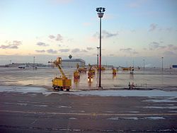
Malton GO Station is a train and bus station in the GO Transit network, located near Toronto Pearson International Airport, in the community of Malton in Mississauga, Ontario, Canada. It is a stop on the Kitchener line, and is a flag stop for Via Rail trains operating between Toronto, London and Sarnia.

<span class="mw-page-title-main">Claireville, Toronto</span> Place in Ontario, Canada

Claireville is a neighbourhood and former hamlet in the city of Toronto, Ontario, Canada. It is located in the northwest corner of Toronto, in the former city of Etobicoke. Today Claireville is almost wholly industrial/commercial.

<span class="mw-page-title-main">Smithfield, Toronto</span> Part of a neighbourhood in Toronto, Ontario, Canada

Smithfield is a neighbourhood and former village in Toronto, Ontario, Canada. Some new residents of Toronto and new immigrants to Canada are attracted to this neighbourhood, mainly because there is a large amount of affordable public housing. It is named after the former village of Smithfield that was located at the intersection of Albion Road and Martin Grove Road. The neighbourhood is located north of the west branch of the Humber River and west of Kipling Avenue.

<span class="mw-page-title-main">Eringate-Centennial-West Deane</span> Neighbourhood in Toronto, Ontario, Canada

Eringate-Centennial-West Deane is a neighbourhood in the city of Toronto, Canada. Eringate-Centennial-West Deane borders the city of Mississauga.

<span class="mw-page-title-main">Toronto Gore Township, Ontario</span>

Toronto Gore is a former incorporated and now geographic township in Ontario, Canada. It is today split between Mississauga and Brampton.

<span class="mw-page-title-main">St. Peter the Apostle Church</span> Historic church in Maryland, United States

St. Peter the Apostle Church was a Roman Catholic church located within the Archdiocese of Baltimore in Baltimore, Maryland. Constructed at the northwest corner of Hollins and South Poppleton Streets and, it was often referred to as "The Mother Church of West Baltimore."

<span class="mw-page-title-main">St. Leo's Roman Catholic Church (Mimico)</span> Church in Toronto, Ontario

St. Leo's Roman Catholic Church is a Catholic church in Toronto, Ontario, Canada. It is located on Royal York Road at Stanley, in the Mimico neighbourhood, part of Etobicoke. It is the oldest Catholic church in Etobicoke and the only Catholic church in Mimico.

<span class="mw-page-title-main">Nativity of the Blessed Virgin Mary Catholic Church</span> United States historic place

The Nativity of the Blessed Virgin Mary Catholic Church is a historic Catholic church in Cassella, an unincorporated community in Mercer County, Ohio, United States. One of several Catholic churches in Marion Township, it has been designated a historic site because of its well-preserved nineteenth-century architecture.

<span class="mw-page-title-main">St. Rose's Catholic Church (St. Rose, Ohio)</span> United States historic place

St. Rose's Catholic Church is a historic Catholic church in St. Rose, an unincorporated community in Marion Township, Mercer County, Ohio, United States.

<span class="mw-page-title-main">St. Mary's Church (Staten Island)</span> Building in New York City, United States of America

The Church of St. Mary is a Roman Catholic parish church in the Roman Catholic Archdiocese of New York, located at 1101 Bay Street, Staten Island, New York City. St. Mary's is the second oldest of the 36 Roman Catholic parishes on Staten Island, having been established in 1852, after St. Peter's (1839), and before St. Joseph's in Rossville (1855).

<span class="mw-page-title-main">Old St. Peter's Church (Poughkeepsie, New York)</span> Building in New York, United States of America

The Old Church of St. Peter is a Roman Catholic church established under the authority of the Roman Catholic Archdiocese of New York in Poughkeepsie, Dutchess County, New York in 1837. It is the second oldest Catholic Church on the Hudson and is considered the Mother Church of the Hudson Valley because from it all the parishes in Ulster and Dutchess counties were founded. The church is also referred to as Our Lady of Mount Carmel since 1965 when St. Peter's parish relocated to Hyde Park, New York and the parish of Our Lady of Mount Carmel church relocated to site.

<span class="mw-page-title-main">Ward 5 (Mississauga)</span>

Ward 5 is a municipal ward located in the northeast corner of the city of Mississauga, Ontario. Carolyn Parrish represents the ward's seat on Mississauga City Council and Peel Regional Council since her election in 2014.

<span class="mw-page-title-main">Renforth station</span> Bus station in Mississauga, Ontario

Renforth, referred to during planning as Renforth Gateway, is a bus station on the border of the cities of Mississauga and Toronto, in Ontario, Canada. Located at Eglinton Avenue and Renforth Drive, it is the eastern terminus of the Mississauga Transitway and is close to the interchange between Highway 401 and Highway 427.

References

  1. 1 2 Hicks, Kathleen A. (2005). Malton: Farms to Flying (PDF). Friends of the Mississauga Library System.
  2. 1 2 3 4 5 6 7 Wilkinson, Matthew; Mair, Nicole (2009). "Elmbank". Mississauga Heritage.
  3. 1 2 "History of Elbank Cemetery". Catholic Cemeteries – Archdiocese of Toronto. Retrieved January 1, 2014.
  4. 1 2 "The Elmbank/Fifth Line Mission History". Catholic Archdiocese of Toronto. Archived from the original on August 25, 2004. Retrieved January 1, 2014.
  5. 1 2 "Elmbank Cemetery". Archaeological Services Inc. Archived from the original on January 2, 2014. Retrieved January 1, 2014.
  6. 1 2 3 "Elmbank Cemetery Project Overview". Catholic Archdiocese of Toronto. Archived from the original on September 27, 2013. Retrieved January 1, 2014.
  7. "Robert James Speers – Father of Thoroughbred Horse Racing on the Canadian Prairies". Assiniboia Downs. May 23, 2013. Archived from the original on January 3, 2014.