The transport infrastructure and services in the Canadian city of Mississauga, Ontario include provincial highways and municipal roads, passenger and freight rail, regional and municipal bus service, and an international airport. It is interconnected with air, road, and rail transportation networks spanning the Greater Toronto Area and beyond.
The Queen Elizabeth Way traverses the southern end of the city from Etobicoke in the northeast to Oakville in the southwest. Also continuing from Etobicoke into Mississauga is Highway 401, which passes south of Toronto Pearson International Airport to the northwest corner of the city and into Milton. There, it intersects with Highway 407, an electronically tolled highway running northeast into Brampton, and southeast toward Lake Ontario and which median defines the municipal boundary between Mississauga and Milton. Where it intersects Highway 403 is the location of the boundaries between Milton in the southwest, Oakville in the southeast, and Mississauga in the north. Highway 401 has six interchanges in Mississauga.[1]:1
Highway 403 traverses Mississauga to the northeast, turning northwest at Cawthra Road until it intersects Highway 401, where it terminates at a stack interchange. From this point, the highway continues northwest as Highway 410 towards Brampton,[1]:1 where it intersects Highway 407.
Highway 427 defines some of the municipal boundary between Mississauga and Toronto on the northeast side of Toronto Pearson International Airport, and is intersected by Highway 409 which terminates at the airport and traverses eastward to Highway 401 in Toronto.[1]:1
The proposed GTA West Corridor would connect to the interchange at Highway 401 and Highway 407 at the northwest periphery of the city.[12]
Airport
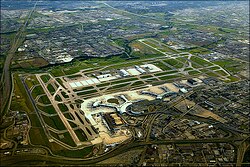
An aerial photograph of Toronto Pearson International Airport looking west-southwest. The white arced building is Terminal 1, and the partially arced building to its right is Terminal 3, the two passenger terminals at the airport.
As of 2013[update] the airport had 1.2millionsqft (0.11millionm2) of cargo-handling facilities and a dedicated cargo apron of 2.5millionsqft (0.23millionm2) with an annual capacity of 1milliont (0.98million long tons).[1]:2
Cycling
The municipal government of Mississauga created a Cycling Master Plan in 2010 and a finalized plan in 2018 that will result in the implementation of 897 kilometres (557mi) of cycling infrastructure to be built by 2045.[15] These will include:[15]
cycle tracks that are physically separated from roads by a curb
bicycle lanes that are separated from roads by barriers such as planters or bollards
bicycle lanes adjacent to road lanes
trails within parks (many cycle tracks are also designated as trails)
other routes shared by cyclists and motorists, such as low-speed roads
As of 2018[update] the city had 54 kilometres (34mi) of bicycle lanes, 88 kilometres (55mi) of boulevard multi-use trails, 221 kilometres (137mi) of off-road multi-use trails, and 91 kilometres (57mi) of shared routes. [16]:1 The cost to expand the network is expected to be about $267 million[16]:7 in annual investments of about $5.3 million.[16]:8
Modalities
About 82% of trips of up to 5 kilometres (3.1mi) within the city are with cars.[16]:25As of 2016[update], 0.6% of trips are completed using a bicycle by 0.3% of the city's residents; of these, 87% are less than 5 kilometres.[16]:25
Safety
The government of the Regional Municipality of Peel established a Vision Zero policy in December 2017 to reduce road-related injuries and fatalities.[16]:19 The goal was to reduce such incidents by 10% by 2022, and to (potentially) completely eliminate them in the long term.[16]:19 A resolution to adopt this policy was passed by Mississauga City Council in February 2018.[16]:20
Of the 473 reported collisions involving bicycles from 2010 to 2013, half resulted in an injury, 10 of which were major injuries, and 4 of which were fatal.[16]:29 Over 90% of these occurred at or near intersections.[16]:29
Future
Renforth station (LRT) under construction in October 2023
The Line 5 Eglinton is an underground light rail line under construction in both Mississauga and Toronto that will have a single station in Mississauga adjacent to the Mississauga Transitway's Renforth station.[3][17] Construction is expected to be completed circa 2030 or 2031,[17] with a later extension to the proposed Pearson Regional Transit Centre to be built later.[18]
The proposed Downtown Mississauga Terminal and Transitway Connection is a "critical piece of transit infrastructure" that would serve the Hurontario LRT, the Mississauga Transitway, and Miway and GO Transit buses.[3]
Two bus rapid transit lines are proposed for the city, one operating along a 2 kilometres (1.2mi) segment of Lakeshore Road and the other a 48 kilometres (30mi) line along Dundas Street from Kipling station in Toronto to Highway 6 in Hamilton.[3]
This page is based on this Wikipedia article Text is available under the CC BY-SA 4.0 license; additional terms may apply. Images, videos and audio are available under their respective licenses.