English Avenue and Vine City

Last updated

English Avenue and Vine City
Sunset Avenue side street - Georgia Dome.JPG
Herndon Home, built by African-American insurance magnate Alonzo Herndon
Atlanta Central.png
Red pog.svg
English Avenue and Vine City
Location in Central Atlanta
Coordinates: 33°45′48″N84°24′37″W / 33.763441°N 84.410341°W / 33.763441; -84.410341
Country United States
State Georgia
County Fulton
Government
  TypeNeighborhoods of Atlanta
Time zone UTC-5 (Eastern (EST))
  Summer (DST) UTC-4 (EDT)
English Avenue banner on street light pole English Avenue banner.JPG
English Avenue banner on street light pole
Vine City sign with Georgia Dome in background Vine City sign with Georgia Dome in background.JPG
Vine City sign with Georgia Dome in background

English Avenue and Vine City are two adjacent and closely linked neighborhoods of Atlanta, Georgia. Together the neighborhoods make up neighborhood planning unit L. [1] The two neighborhoods are frequently cited together in reference to shared problems and to shared redevelopment schemes and revitalization plans. [2] [3] [4] [5]

Contents

English Avenue is bounded by the railroad line and the Marietta Street Artery neighborhood to the northeast, Northside Drive, the North Avenue railyards and downtown Atlanta to the east, Joseph E. Lowery Blvd. (formerly Ashby St.) and the Bankhead neighborhood to the west, and Joseph E. Boone Blvd. (called Simpson St. until 2008) and Vine City to the south. Its population was 3,309 in 2010. [6]

Vine City is bounded by Joseph E. Boone Blvd. (Simpson) and the English Avenue neighborhood to the north, Northside Drive and downtown Atlanta to the east, Martin Luther King Jr. Dr. (formerly Hunter St.) and the Atlanta University Center to the south, and Joseph E. Lowery Blvd. (Ashby) and the Washington Park neighborhood to the west. Its population was 2,785 in 2010. [6]

A section of the area, "The Bluff," is infamous throughout Metro Atlanta as a high crime area, but in late 2011, English Avenue and Vine City were the focus of multiple improvement plans, including a network of parks and trails, [2] [7] increased police presence, and "rebranding" for a more positive image. [8] [9] [10] Construction is to start on the new Rodney Cook Sr. Park.

History

Houses in proposed Sunset Avenue Historic District Sunset Avenue house.JPG
Houses in proposed Sunset Avenue Historic District
Houses in proposed Sunset Avenue Historic District - in background, Herndon Stadium and Fountain Hall at Morris Brown College Sunset Avenue houses - Herndon - MBC.JPG
Houses in proposed Sunset Avenue Historic District - in background, Herndon Stadium and Fountain Hall at Morris Brown College
Former church on King Dr., Vine City Former church on King Dr., Vine City.JPG
Former church on King Dr., Vine City
John F. Kennedy Park, Vine City John F. Kennedy Park.JPG
John F. Kennedy Park, Vine City

Development

What is now the English Avenue neighborhood was purchased in 1891 by son of Atlanta mayor James W. English, James W. English Jr., a hot-headed man [11] who earned income by subletting convict labor. [12] It was created as a white working-class neighborhood. Simpson Road was long a residential race barrier with whites to the north and blacks to the south. [13] Today's English Avenue was known at different times as Bellwood [14] and as Western Heights. In 1910 the Western Heights school (later renamed Kingbery after a principal of the school, then renamed English Avenue Elementary School) was built at the northeast corner of English Ave. and Pelham St. [15]

Overcrowding in the neighborhood's school is documented as a serious issue from at least 1910 through 1946 (photo), notwithstanding multiple expansions of the facility. [16] [17] [18] [19]

The area south of Simpson Road today's Vine City was settled at the end of the 1800s by large land owners, and a predominantly African-American residential area was established, though there were also white subdivisions, schools, and churches. A mix of social classes were present. In 1910 Alonzo F. Herndon, founder of the Atlanta Life Insurance Company, built his home at 587 University Place, now listed on the National Register and open to visitors. [20]

Racial tension and transition

The Great Atlanta fire of 1917 contributed to the already great need for housing for African Americans and by the 1920s-1940s, despite violence and bombings trying to prevent it, black residents started to move north across Simpson Road. [13]

In 1941, the Eagan Homes and Herndon Homes public housing projects opened and as a result, the black population in the area increased. On Hunter Street (now Martin Luther King Jr. Drive), white business owners once lived behind their stores, but in the 1940s, black owners started taking over these businesses. [20] In 1947 Paschal's Restaurant, an Atlanta soul food landmark and meeting place for civil rights leaders, opened in its original location on West Hunter Street. [20] In 1951, the English Avenue Elementary School's designation was changed from white to black in response to most whites having moved out of the area. [21]

Heyday and Civil Rights

During the mid-20th century, the area was a middle-class African-American neighborhood. [22] Commercial areas included English Avenue; Simpson Street/Road, in its heyday in the 1950s and 1960s; and Bankhead Highway, which was part of the US Highway system, and was in its splendor in the 1960s. Dr. Martin Luther King Jr. moved to the area in 1967, and his widow Coretta Scott King continued to live here until she moved to a Peachtree Road luxury condominium purchased for her by Oprah Winfrey in 2004.

In 1960, the English Avenue elementary school was dynamited, likely in retaliation for civil rights demonstrations by Black activists. [23] Mayor William B. Hartsfield condemned the dynamiting as the work of those from outside Atlanta, "the outhouse set". [21] The area experienced notable pro- and anti-Black Power riots in 1966 [24] and 1967. [25]

Decline and crime

Abandoned houses, Proctor at Oliver streets, English Avenue English Avenue abandoned houses.JPG
Abandoned houses, Proctor at Oliver streets, English Avenue

Suburbanization started draining the area's vitality starting in the 1970s. [13] Over the following decades, it attracted buyers and sellers of heroin, and deteriorated into a corner of poverty in the city, characterized by large numbers of abandoned, boarded-up houses. [22]

In 1995 the English Avenue Elementary School closed. [15]

In 2006, a "no-knock raid" in search of a drug dealer, burst into the home of Kathryn Johnston. Ms. Johnston, in her 80s, opened fire on the officers and wounded three and was killed by return fire from the officers. The incident resulted in much anger in the neighborhood and in close scrutiny of police use of "no-knock warrants" in drug raids. [26]

The 2008 tornado caused major damage in areas of Vine City (photos).

The 2010s foreclosure crisis hit the neighborhoods hard. [27] In April 2012, Creative Loafing reported that "on some streets more houses are boarded up than are lived in". Occupy Atlanta protested the Vine City foreclosure of Mrs. Pamela Flores by Bank of America. [28]

The desperate state of the area was described by reporter Thomas Wheatley in Creative Loafing in September 2012 as: [29]

"boarded-up homes built among the trees along the narrow streets,…people loitering in the middle of vacant lots, casting hollow stares at passing motorists, and…young men hanging out on street corners, hollering at passers-by and then to lookouts down the street"

Revitalization

Recent revitalization efforts in the Vine City neighborhood include the Westside Commons town home complex, photographed here during the 2014 snowstorm. Rare snow day in Vine City 2014.JPG
Recent revitalization efforts in the Vine City neighborhood include the Westside Commons town home complex, photographed here during the 2014 snowstorm.

1990s: Failed "empowerment zone"

In November 1994, the Atlanta Empowerment Zone was established, a 10-year, $250 million federal program to revitalize Atlanta's 34 poorest neighborhoods including the Bluff. Scathing reports from both the U.S. Department of Housing and Urban Development and the Georgia Department of Community Affairs revealed corruption, waste, bureaucratic incompetence, and interference by mayor Bill Campbell. [30] [31]

Replacement of public housing projects

As part of the Atlanta Housing Authority's systematic replacement of public housing projects by mixed-income communities (MIC), Eagan Homes was demolished and the Magnolia Park MIC replaced it. Herndon Homes was demolished in 2011. [32]

Historic Westside Village and Walmart

New townhomes at Westside Village, August 2012 Westside Village - new development in Vine City.JPG
New townhomes at Westside Village, August 2012
A Walmart under construction at Westside Village, August 2012 Westside Village - new development in Vine City 2.JPG
A Walmart under construction at Westside Village, August 2012

In 1999, the Atlanta Housing Authority first announced plans for the "Historic Westside Village", a $130 million commercial, residential and retail project at the area's southern end near Martin Luther King Jr. Dr. at Ashby St. [33] A Publix supermarket opened in May 2002 [34] but the overall project stalled by 2003 as further anchor tenants did not materialize. [35] This, along with disappointing sales, caused the Publix - the only full-sized supermarket for miles around - to close in December 2009. [36] Creative Loafing called the project the most notorious "municipal boondoggle...to have tarred Atlanta" during mayor Bill Campbell's era; the project "fell victim to...cronyism, bureaucratic incompetence and a flagrant disregard for federal lending guidelines". [37] In December 2010 things looked up as the Atlanta Development Authority announced plans for Wal-Mart to open a store on the site, which Mayor Kasim Reed called "an end to the food desert in the area". [38] [39] In January 2013 the Wal-Mart opened for business. [40] [41]

Black-white coalition

The Christian Science Monitor reported that by 2008, businessman John Gordon and Rev. Anthony Motley, a 20-year resident of The Bluff, "Atlanta's roughest 'hood", had "formed a black-white coalition seeking angel investors" and brought together "local businesses, neighboring Georgia Tech, and church leaders to inspire not just city and private investment, but also to light a spark of hope among law-abiding residents – many of them older people fearful of the streets outside their front doors. Their unusual friendship" had "helped inspire two massive clean-up efforts, a small but significant drop in crime, and glimmers of fresh paint and clean-swept front walks." [42]

Rodney Cook Sr. Park

Cook Park is under construction by a partnership consisting of the City of Atlanta's Department of Watershed Management, The Trust for Public Land of Georgia, and the National Monuments Foundation. The park will consist of a system of storm water management including a retention pond similar to the one in nearby Historic Old Fourth Ward Park, walking trails and amenities including a terraced amphitheater and splash pad [43] and statues and monuments honoring a number of prominent Atlantans and Civil Rights leaders, including Martin Luther King Jr. and Booker T. Washington. [44]

The site, located along the south side of Joseph E. Boone Boulevard, has been vacant for many years, after the city purchased several homes there that perpetually fell victim to severe flooding caused by historic mismanagement in the Proctor Creek watershed. In December 2011 Park Pride, a greenspace advocacy group, proposed a network of greenspaces and parks that—through the incorporation of green infrastructure—would help mitigate the recurring flooding from stormwater runoff that plagued the neighborhoods of Vine City and English Avenue for years. [2] In 2015, the City began cleaning the site, and the Trust For Public Land joined the partnership to plan, raise funds, and construct the park above and around the stormwater management solutions. The National Monuments Foundation and Rodney Cook will fund and construct "sculptures of civil rights leaders, an urban farm, and an 80-foot "peace column." [45] [46]

The design mimics Mims Park, now demolished, which was once a prominent city park in Vine City named after Livingston Mims, who was mayor of Atlanta from 1901 to 1903. It was designed by Frederick Law Olmsted's sons, who also designed Piedmont Park in Midtown. [47]

English Avenue Elementary School, site of a proposed "green technology global community center" English Avenue School.JPG
English Avenue Elementary School, site of a proposed "green technology global community center"

In 2017, it was announced that construction will commence, however the park will be named Rodney Cook Sr. Park and it is hoped to stimulate revitalization. [48] Along with this park, Kathryn Johnston Memorial Park, named in honor of former neighborhood resident Kathryn Johnston, was also built in the neighborhood, being officially opened in 2019. [49]

Other efforts since 2010

In May 2010, the non-profit Greater Vine City Opportunities Program, founded and directed by "Able" Mable Thomas bought the English Avenue Elementary School with the intention to convert it into a "state of the art green technology global community center". [50]

In March 2011, NPU L voted in favor of a Sunset Avenue Historic District from Joseph E. Boone Blvd. southward to Magnolia Street. [5]

In December 2011, the nonprofit Friends of English Avenue arranged for a married couple, both police officers, to live rent-free in a neighborhood house. "Able" Mable Thomas and others expressed the need for a "rebranding" of the area similar to the one which rebranded crime and prostitution-infested Stewart Avenue in Southwest Atlanta as Metropolitan Parkway. [51]

Other transformative efforts continued in 2014. A new Urban Perform gym opened on Joseph E. Boone Blvd designed to empower residents to make healthy lifestyle changes. [52] The gym also hosts a local farmer's market on Saturdays which offers fresh, organic, produce from local community gardens. One of these gardens is the Historic Westside Gardens, which hopes to expand through a cooperative effort with the National Monument Foundation into Mims Park.

The Westside Works, a non-profit and jobs training center, opened in 2014 at the site of former E.R. Carter School at 80 Joseph E. Lowery Blvd. NW. Their mission is to serve the underserved by teaching new skills crucial to the modern workforce. In Summer 2014 they graduated their first class of trainees. [53]

2010s investments

There are multiple efforts underway to encourage and promote home ownership in Vine City and English Avenue. Invest Atlanta has a trust fund which provides up to 10% of the downpayment for a first time homeowner, up to $15,000. [54] Home Atlanta 4.0 provides up to 5% of the house cost, but waives the first-time buyer requirement.

Invest Atlanta and the Arthur M. Blank Foundation partnered to provide $30 million in seed money for innovative and transformative non-profits to help revitalize the two neighborhoods.

In 2018, Friendship Baptist church held talks with developers regarding Downtown West, a new construction development adjacent to the new home of the Atlanta Falcons, Mercedes-Benz Stadium. [55]

Culture

Revitalization in English Avenue continues with work on multiple community gardens. A before & after picture of the English Avenue Community Farm. English Avenue Community Garden.jpg
Revitalization in English Avenue continues with work on multiple community gardens. A before & after picture of the English Avenue Community Farm.

Festivals

In 2012, an annual festival was established, the Historic Westside Village Festival. The event includes educational seminars, vendors, a Kids Zone, and a concert stage, with proceeds going to local charities and services. In 2013 the festival took place on September 21. [56]

The annual English Avenue Festival of Lights is directed by the Historic Westside Cultural Arts Council. The Festival is an exhibition of the community and encourages community members to be a light in their neighborhood. There is a Children's pavilion, free food and drinks, and an exhibition of local non-profits.

Churches

The area is home to a large concentration of churches, including: [57]

Points of Interest

"The Bluff"

The Bluff is a district within the area that is infamous throughout metro Atlanta for the availability of drugs, heroin in particular. [58] [59] [22]

The borders of The Bluff are defined differently by different sources. For example, the Atlanta Journal-Constitution [22] and Creative Loafing [59] both defined The Bluff as including all of English Avenue and Vine City. However, a more recent and in-depth December 2011 series of reports by 11 Alive TV news, referred to The Bluff as a "section of English Avenue". [8] [9] [10] The English Avenue/Vine City area has some of the highest poverty and crime rates in the city, with the Carter St. area surrounding the Vine City MARTA station ranking in 2010 as the #1 most dangerous neighborhood in Atlanta and #5 in the United States. [60] [61]

Public transportation

The area is served by the MARTA rail Blue Line and Green Line at the Vine City and Ashby stations. Bus lines serving the neighborhood are the 3 along Martin Luther King Jr. Drive, the 51 along Joseph E. Boone Blvd., and the 26 along Cameron M. Alexander Blvd. (known as Kennedy St. until 2010), [62] English Avenue and Donald L. Hollowell Pkwy. [63]

Famous residents

Related Research Articles

<span class="mw-page-title-main">Midtown Atlanta</span> Neighborhood in Fulton County, Georgia, United States

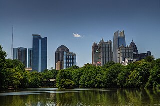
Midtown Atlanta, or Midtown, is a high-density commercial and residential neighborhood of Atlanta, Georgia. The exact geographical extent of the area is ill-defined due to differing definitions used by the city, residents, and local business groups. However, the commercial core of the area is anchored by a series of high-rise office buildings, condominiums, hotels, and high-end retail along Peachtree Street between North Avenue and 17th Street. Midtown, situated between Downtown to the south and Buckhead to the north, is the second-largest business district in Metro Atlanta. In 2011, Midtown had a resident population of 41,681 and a business population of 81,418.

East Atlanta is a neighborhood on the east side of Atlanta, Georgia, United States. The name East Atlanta Village primarily refers to the neighborhood's commercial district.

The Atlanta BeltLine is a 22 miles (35 km) open and planned loop of multi-use trail and light rail transit system on a former railway corridor around the core of Atlanta, Georgia. The Atlanta BeltLine is designed to reconnect neighborhoods and communities historically divided and marginalized by infrastructure, improve transportation, add green space, promote redevelopment, create and preserve affordable housing, and showcase arts and culture. The project is in varying stages of development, with several mainline and spur trails complete and others in an unpaved, but hikeable, state. Since the passage of the More MARTA sales tax in 2016, construction of the light rail streetcar system is overseen by MARTA in close partnership with Atlanta BeltLine, Inc.

<span class="mw-page-title-main">Jefferson Park, Los Angeles</span> Neighborhood of Los Angeles in California, United States

Jefferson Park is a neighborhood in the South Los Angeles region of the City of Los Angeles, California. There are fourteen Los Angeles Historic-Cultural Monuments in the neighborhood, and in 1987, the 1923 Spanish Colonial Revival Jefferson Branch Library was added to the National Register of Historic Places. A portion of the neighborhood is a designated Historic Preservation Overlay Zone (HPOZ).

<span class="mw-page-title-main">Virginia–Highland</span> Neighborhoods of Atlanta in Fulton County, Georgia, United States

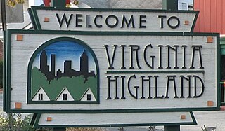
Virginia–Highland is an affluent neighborhood of Atlanta, Georgia, founded in the early 20th century as a streetcar suburb. It is named after the intersection of Virginia Avenue and North Highland Avenue, the heart of its trendy retail district at the center of the neighborhood. The neighborhood is famous for its bungalows and other historic houses from the 1910s to the 1930s. It has become a destination for people across Atlanta with its eclectic mix of restaurants, bars, and shops as well as for the Summerfest festival, annual Tour of Homes and other events.

<span class="mw-page-title-main">Sylvan Hills, Atlanta</span> Neighbourhood of Atlanta, Georgia, United States

Sylvan Hills is a historic intown neighborhood in southwest Atlanta, Georgia, United States.

<span class="mw-page-title-main">Old Fourth Ward</span> Neighborhoods of Atlanta in Fulton County, Georgia, United States

The Old Fourth Ward, often abbreviated O4W, is an intown neighborhood on the eastside of Atlanta, Georgia, United States. The neighborhood is best known as the location of the Martin Luther King Jr. historic site.

<span class="mw-page-title-main">Westview, Atlanta</span> CDP in Georgia, United States

Westview is a historic intown neighborhood located in southwest Atlanta, Georgia. It is named for the Westview Cemetery that borders the neighborhood to the northwest. The neighborhood is made up of a mixture of architectural styles including Arts & Crafts bungalows, Four-Squares, Tudors, Minimal Traditional houses, and Ranch style houses.

<span class="mw-page-title-main">Capitol View, Atlanta</span>

Capitol View is a historic intown southwest Atlanta, Georgia neighborhood. The neighborhood is 2.5 miles from downtown and was named for its views of the Georgia State Capitol building. Its boundaries include Metropolitan Parkway to the east, Lee Street to the west, and the Beltline to the north. On the south, the border follows Arden Street, Deckner Avenue, and Perkerson Park.

<span class="mw-page-title-main">Adair Park</span>

Adair Park is a residential neighborhood located southwest of downtown Atlanta. It has the form of a left curly bracket, bordered by the MARTA north–south rail line on the northwest, the BeltLine trail on the southwest and Metropolitan Parkway on the east. Historically Adair Park also included the area from Metropolitan Parkway to McDaniel Street on the east, but the city now considers that area part of the Pittsburgh neighborhood.

<span class="mw-page-title-main">Boulevard (Atlanta)</span>

Boulevard is a street in and, as a corridor, a subdistrict, of the Old Fourth Ward neighborhood of Atlanta, Georgia. The street runs east of, and parallel to, Atlanta's Downtown Connector. It begins at Ponce de Leon Avenue in the north, passing through the Old Fourth Ward, Cabbagetown, and Grant Park, and forming the border between Chosewood Park on the west and Boulevard Heights and Benteen Park to the east. It ends at McDonough Boulevard in the south, at the Federal Penitentiary.

West Midtown, also known as Westside, is a colloquial area, comprising many historical neighborhoods located in Atlanta, Georgia. Once largely industrial, West Midtown is now the location of urban lofts, art galleries, live music venues, retail and restaurants.

Marietta Street Artery is an officially defined neighborhood of the city of Atlanta, Georgia, part of the West Midtown area of Atlanta, also known as the "Westside."

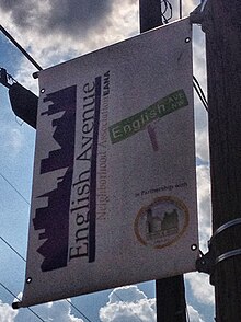
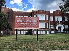
Cameron M. Alexander was an American Baptist minister. He was the leader of the 12,000-member Antioch Baptist Church North and community leader in the English Avenue neighborhood in Atlanta.

<span class="mw-page-title-main">Gentrification of Atlanta</span> Gentrification of Atlantas inner-city neighborhoods

Gentrification of Atlanta's inner-city neighborhoods began in the 1970s, and it has continued, at varying levels of intensity, into the present. Many factors have contributed to the city's gentrification. A major increase in gentrification that occurred in the last years of the 20th century has been attributed to the 1996 Summer Olympics. However, during the 2000s, Atlanta underwent a profound transformation demographically, physically, and culturally. Suburbanization, rising prices, a booming economy, and new migrants decreased the city’s black percentage from a high of 67% in 1990 to 54% in 2010. From 2000 to 2010, Atlanta gained 22,763 white residents, 5,142 Asian residents, and 3,095 Hispanic residents, while the city’s black population decreased by 31,678. Much of the city’s demographic change during the decade was driven by young, college-educated professionals: from 2000 to 2009, the three-mile radius surrounding Downtown Atlanta gained 9,722 residents aged 25 to 34 holding at least a four-year degree, an increase of 61%. Between the mid-1990s and 2010, stimulated by funding from the HOPE VI program, Atlanta demolished nearly all of its public housing, a total of 17,000 units and about 10% of all housing units in the city. In 2005, the $2.8 billion BeltLine project was adopted, with the stated goals of converting a disused 22-mile freight railroad loop that surrounds the central city into an art-filled multi-use trail and increasing the city’s park space by 40%. Lastly, Atlanta’s cultural offerings expanded during the 2000s: the High Museum of Art doubled in size; the Alliance Theatre won a Tony Award; and numerous art galleries were established on the once-industrial Westside.

The History of Virginia–Highland, the Intown Atlanta neighborhood, dates back to 1812, when William Zachary bought and built a farm on 202.5 acres (0.819 km2) of land there. At some point between 1888 and 1890 the Nine-Mile Circle streetcar arrived,, making a loop of what are now Ponce de Leon Avenue, North Highland Avenue, Virginia Avenue, and Monroe Drive. Atlantans at first used the line to visit what was then countryside, including Ponce de Leon Springs, but the line also enabled later development in the area. Residential development began as early as 1893 on St. Charles and Greenwood Avenues, must most development took place from 1909 through 1926 — solidly upper-middle class neighborhoods, kept all-white by covenant.

<span class="mw-page-title-main">Edgewood Avenue</span> Street in Atlanta, Georgia, United States

Edgewood Avenue is a street in Atlanta, Georgia, United States which runs from Five Points in Downtown Atlanta, eastward through the Old Fourth Ward. The avenue runs in the direction of the Edgewood neighborhood, and stops just short of it in Inman Park. Edgewood Avenue was first important as the route of a streetcar line to Inman Park, Atlanta's first garden suburb and home to many of its most prominent citizens. Today, the avenue is known for its restaurants and nightlife around its intersection with Boulevard.

Westside in Atlanta may mean:

<span class="mw-page-title-main">Historic Westside Village</span>

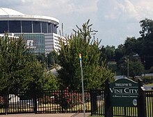
"'Historic Westside Village"' is a mixed-use development in Vine City, Atlanta including a Walmart, other retail stores, and apartment complexes.

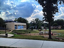
Lindsay Street Park is a public park in the English Avenue neighborhood of Atlanta, Georgia. Opened in 2015, it is the first park to be opened in English Avenue

References

  1. "City of Atlanta, NPU L Map" (PDF). 174.37.215.145. Retrieved April 16, 2018.[ permanent dead link ]
  2. 1 2 3 Thomas Wheatley, "Ambitious parks plans could give Vine City, English Avenue another chance", Creative Loafing, December 8, 2011
  3. "grants to the Vine City and English Avenue communities" in "Vine City targeted for revitalization", Atlanta Journal-Constitution, October 23, 2010
  4. ""Vine City/English Avenue Trust Fund", Invest Atlanta". Investatlanta.com. Archived from the original on 11 February 2012. Retrieved 16 April 2018.
  5. 1 2 "The Vine City and English Avenue neighborhoods have voiced their support" in Sunset Avenue Historic District Archived 2012-04-25 at the Wayback Machine
  6. 1 2 2010 U.S. census figures as tabulated by WalkScore
  7. ""Proctor Creek North Avenue Watershed basin", Park Pride" (PDF). Archived from the original (PDF) on April 20, 2012. Retrieved December 12, 2011.
  8. 1 2 "The Bluff: Atlanta's forgotten neighborhood", 11 Alive News (Atlanta) [ permanent dead link ]
  9. 1 2 ""Re-branding The Bluff and English Avenue in the ATL', 11 Alive News (Atlanta), December 22, 2011". Archived from the original on January 16, 2013. Retrieved February 21, 2012.
  10. 1 2 ""Return to The Bluff: Not Forgotten any longer", 11 Alive News (Atlanta), December 19, 2011". Archived from the original on January 15, 2013. Retrieved February 21, 2012.
  11. "Berry and English Fight at the Club". Newspapers.com. The Atlanta Constitution. March 5, 1898. p. 5. Retrieved March 31, 2024. Judge Berry charges that Mr. English, Jr., drew a pistol and struck him in the face. ...I saw young English's pistol and I am told that he tried to shoot me, but failing to do so, struck me in the face with the weapon.
  12. "Prisoners Secured From State For $8 Per Month and Hired Out For $14 and $20". Newspapers.com. The Atlanta Journal. October 27, 1902. p. 5. Retrieved March 31, 2024. James W. English, Jr., sublets 55 convicts to Thomas Jones, at Adrian, Ga.
  13. 1 2 3 "English Avenue Community Redevelopment Plan update" (PDF). Atlantaga.gov. Archived from the original (PDF) on 10 July 2010. Retrieved 16 April 2018.
  14. "Years of neglect turn English Avenue home into rotted shell", Atlanta Journal-Constitution, May 26, 2002
  15. 1 2 ""English Avenue Community Campus", Greater Vine City Opportunities Program, Inc". Englishavenuecampus.net. Archived from the original on 25 April 2012. Retrieved 16 April 2018.
  16. "Citizens ask for better facilities: Crowded condition of Western Heights school cause of complaint", Atlanta Georgian and News, August 19, 1910, p.8
  17. Clifford M. Kuhn et al., Living Atlanta: An Oral History of the City, 1914–1948
  18. "Metro Atlanta « Georgia Historic Newspapers". atlnewspapers.galileo.usg.edu. Retrieved April 16, 2018.
  19. "Crowded schools: more students than ever before threaten to clog all facilities" Life magazine, October 7, 1946, p.40
  20. 1 2 3 ""About Vine City", Vine City Health and Housing Ministry". Vinecity.net. Archived from the original on 25 April 2012. Retrieved 16 April 2018.
  21. 1 2 "Furtive Dynamiters Blast Big Atlanta Negro School", Meriden Record, December 13, 1960
  22. 1 2 3 4 Andria Simmons, "Heroin a deadly draw in 'Bluff'", Atlanta Journal-Constitution, September 7, 2011
  23. Blau, Max; Michney, Todd (December 12, 2020). "Terror in the City Too Busy to Hate: How the English Avenue School Bombing Challenged Atlanta's Popular Myth of Racial Progress". Atlanta Studies. Retrieved March 24, 2023.
  24. "Forming Mobs Turn into Anti-Black Power Rally", Lodi News-Sentinel, September 6, 1966
  25. "Negro Disorders Erupt in Atlanta Slum Section", Rome News-Tribune, October 24, 1967
  26. Patrik Jonsson, "After Atlanta raid tragedy, new scrutiny of police tactics", Christian Science Monitor, November 29, 2006
  27. "11alive.com". WXIA. Retrieved April 16, 2018.[ permanent dead link ]
  28. "Search - Atlanta Creative Loafing". Atlanta Creative Loafing. Retrieved April 16, 2018.
  29. "The Stadium Effect", Thomas Wheatley, Creative Loafing, September 6, 2012
  30. "Empowerment zones: Boondoggle or aid to poor?", Atlanta Business Chronicle, November 6, 2000
  31. Scott Henry, "Federal grants go to groups with shaky past", Creative Loafing, September 26, 2007
  32. Joeff Davis, "Photo of the Day: Herndon Homes demolition", Creative Loafing, February 2010]
  33. "Westside due a $130 million redo", Atlanta Journal-Constitution, March 16, 1999
  34. "A DREAM FULFILLED: Intown Publix to open", Atlanta Journal-Constitution, May 30, 2002
  35. David Pendered, "Entangled in Vine City; 'The city lost control': Officials scramble to save project to renew Historic Westside Village" Archived 2012-04-07 at the Wayback Machine , Atlanta Journal-Constitution, July 28, 2003
  36. "Historic Westside Village Publix To Close, Residents Not Happy". Majicatl.com. December 9, 2009. Retrieved April 16, 2018.
  37. Scott Henry, "Westside Do-over", Creative Loafing, April 26, 2006
  38. "Home". Atlantada.com. Retrieved April 16, 2018.[ permanent dead link ]
  39. "Home" (PDF). Atlantada.com. Archived from the original (PDF) on January 15, 2011. Retrieved April 16, 2018.
  40. EndPlay (January 23, 2013). "New Walmart opens in Vine City". Wsbtv.com. Retrieved April 16, 2018.
  41. "Vine City/AUC Walmart Grand Opening on Wednesday 1/23: Walmart has said they are ready to open to the public", Marc Richardson, Cascade Patch, January 21, 2013
  42. "New Life for Atlanta's English Avenue", Patrik Jonsson,Christian Science Monitor, December 11, 2008
  43. "Park Design". Cooks Park. Archived from the original on October 27, 2017. Retrieved October 26, 2017.
  44. "Remember Historic Mims Park? It Could Start Happening Soon". Atlanta.curbed.com. Retrieved April 16, 2018.
  45. McWilliams, Jeremiah (July 16, 2012). "Atlanta council approves Mims park proposal". Atlanta Journal-Constitution. Retrieved July 18, 2012.
  46. National Monuments Foundation (October 22, 2012). "Historic Mims Park". YouTube . Retrieved April 16, 2018.
  47. Wheatley, Thomas (December 8, 2011). "Ambitious parks plans could give Vine City, English Avenue another chance". Creative Loafing. Retrieved July 18, 2012.
  48. "Westside park could have potential of Historic Fourth Ward Park". Myajc.com. Retrieved April 16, 2018.
  49. Green, Josh (November 22, 2019). "Atlanta park opens in honor of 92-year-old neighborhood matriarch killed by police". Curbed Atlanta . Vox Media . Retrieved March 23, 2020.
  50. ""About GVCOP", Greater Vine City Opportunities Program, Inc". Englishavenuecampus.net. Archived from the original on 25 April 2012. Retrieved 16 April 2018.
  51. ""Re-branding the Bluff and English Ave. in the ATL", WXIA-TV (11 Alive), December 22, 2011". 11alive.com. Archived from the original on 15 January 2013. Retrieved 16 April 2018.
  52. Staples, Gracie Bonds (June 18, 2014). "A safe place to exercise". Atlanta Journal-Constitution. Retrieved September 10, 2014.
  53. "Our Programs « Westside Works". Westsideworks.org. Retrieved April 16, 2018.
  54. "Vine City / English Avenue Trust Fund (HOAP) | Invest Atlanta". Archived from the original on September 4, 2014. Retrieved September 10, 2014.
  55. "Downtown West Envisioned Around New Falcons". Bizjournals.com. Retrieved April 16, 2018.
  56. "Historic Westside Village Festival website". Hwvfestival.org. Archived from the original on 6 July 2013. Retrieved 16 April 2018.
  57. "Divine mission gives way to blighted streets". Myajc.com. Retrieved April 16, 2018.
  58. Atlanta Magazine, "The King File", 4/15/2009 Archived 2011-07-22 at the Wayback Machine
  59. 1 2 "Search - Atlanta Creative Loafing". Atlanta Creative Loafing. Retrieved April 16, 2018.
  60. Alexis stevens, "Study: 4 Atlanta neighborhoods among nation's most dangerous", Atlanta Journal-Constitution, October 5, 2010
  61. "My Portfolios - Finance Portfolio". Dailyfinance.com. Retrieved April 16, 2018.
  62. City of Atlanta online, ordinace 10-O-1420 Archived 2011-11-11 at the Wayback Machine
  63. "MARTA". Itsmarta.com. Retrieved April 16, 2018.
  64. "The Herman Cain of Atlanta's West Side". Cascade.patch.com. October 16, 2011. Retrieved April 16, 2018.
  65. Harmon Perry, "Gladys Knight and the Pips: Too hot to stop", Jet magazine, June 20, 1974
  66. 1 2 "Sidewalk Stories". Peopletv.org. Archived from the original on 25 April 2012. Retrieved 16 April 2018.
  67. Scott Gargan, "Connecticut Comedy Festival at Bridgeport arena", The News-Times (Danbury, Conn.), October 11, 2011
  68. "Rapper Ralo Talks The Bluff, Atlanta's Drug-Infested Neighborhood". Vibe.com. March 5, 2018. Retrieved April 16, 2018.