
North Druid Hills, also known as Briarcliff or Toco Hills, is an unincorporated community and census-designated place in DeKalb County, Georgia, United States. The population was 18,947 at the 2010 census. The commercial center of the area is the Toco Hill Shopping Center, located near the intersection of North Druid Hills Road and LaVista Road.

Morningside Heights is a neighborhood on the West Side of Upper Manhattan in New York City. It is bounded by Morningside Drive to the east, 125th Street to the north, 110th Street to the south, and Riverside Drive to the west. Morningside Heights borders Central Harlem and Morningside Park to the east, Manhattanville to the north, the Manhattan Valley section of the Upper West Side to the south, and Riverside Park to the west. Broadway is the neighborhood's main thoroughfare, running north–south.
Piedmont Park is an urban park in Atlanta, Georgia, located about 1 mile (1.6 km) northeast of Downtown, between the Midtown and Virginia Highland neighborhoods. Originally the land was owned by Dr. Benjamin Walker, who used it as his out-of-town gentleman's farm and residence. He sold the land in 1887 to the Gentlemen's Driving Club, who wanted to establish an exclusive club and racing ground for horse enthusiasts. The Driving Club entered an agreement with the Piedmont Exposition Company, headed by prominent Atlantan Charles A. Collier, to use the land for fairs and expositions and later gave the park its name.
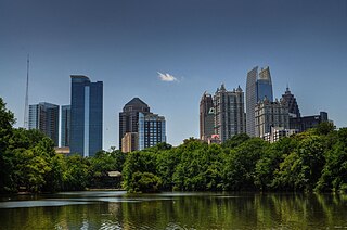
Midtown Atlanta, or Midtown, is a high-density commercial and residential neighborhood of Atlanta, Georgia. The exact geographical extent of the area is ill-defined due to differing definitions used by the city, residents, and local business groups. However, the commercial core of the area is anchored by a series of high-rise office buildings, condominiums, hotels, and high-end retail along Peachtree Street between North Avenue and 17th Street. Midtown, situated between Downtown to the south and Buckhead to the north, is the second-largest business district in Metro Atlanta. In 2011, Midtown had a resident population of 41,681 and a business population of 81,418.
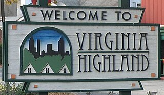
Virginia–Highland is an affluent neighborhood of Atlanta, Georgia, founded in the early 20th century as a streetcar suburb. It is named after the intersection of Virginia Avenue and North Highland Avenue, the heart of its trendy retail district at the center of the neighborhood. The neighborhood is famous for its bungalows and other historic houses from the 1910s to the 1930s. It has become a destination for people across Atlanta with its eclectic mix of restaurants, bars, and shops as well as for the Summerfest festival, annual Tour of Homes and other events.

Reynoldstown is a historic district and intown neighborhood on the near east side of Atlanta, Georgia, located two miles from downtown. The neighborhood is gentrifying and attracting new families, empty-nesters, Atlantans opposed to long commutes; as well as diverse culture of first-time homebuyers, single professionals, artist and students due to its close proximity to other nearby intown neighborhoods, high walkability index, urban amenities and nearby bohemian hotspots on Carroll Street in the adjoined-at-the-hip also historic Cabbagetown neighborhood and in other surrounding communities.

Ansley Park is an intown residential district in Atlanta, Georgia, located just east of Midtown and west of Piedmont Park. When developed in 1905-1908, it was the first Atlanta suburban neighborhood designed for automobiles, featuring wide, winding roads rather than the grid pattern typical of older streetcar suburbs. Streets were planned like parkways with extensive landscaping, while Winn Park and McClatchey Park are themselves long and narrow, extending deep into the neighborhood.
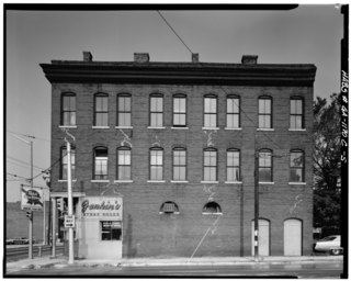
The following is a list of neighborhoods and commercial districts in Sioux City, Iowa.

Clear Creek is a stream in northeast Atlanta that is a tributary to Peachtree Creek and part of the Chattahoochee River watershed. It has two main branches, one originating east of the high ground along which Boulevard runs and another to the west originating on the northeast side of downtown Atlanta. The easterly branch of Clear Creek begins in several springs and branches in what are now Inman Park and the Old Fourth Ward. Flowing north, the creek was joined by other branches and springs, including Angier Springs near the end of Belgrade Avenue and the so-called Ponce de Leon Springs, which were “discovered” during railroad construction in the 1860s and gave rise to the eponymous park and avenue.

Morningside/Lenox Park is an intown neighborhood in Atlanta, Georgia founded in 1923. It is located north of Virginia-Highland, east of Ansley Park and west of Druid Hills. Approximately 3,500 households comprise the neighborhood that includes the original subdivisions of Morningside, Lenox Park, University Park, Noble Park, Johnson Estates and Hylan Park.
Lindridge/Martin Manor is an intown neighborhood of Atlanta, Georgia. It consists mostly of the single-family homes located off Lindbergh Drive in between I-85 and Cheshire Bridge Road. In addition, it includes a small commercial area of three streets west of I-85 bounded by Peachtree Creek, Piedmont Road and the Southern railroad. The neighborhood's boundaries are I-85 on the northwest, Morningside-Lenox Park on the south, and North Druid Hills in unincorporated DeKalb County, Georgia on the east.
Easton was a farming community located at the crossroads of Plaster Bridge Road and Monroe Drive, a location where today, three intown neighborhoods of Atlanta come together: Morningside-Lenox Park, Piedmont Heights and Ansley Park. Farmers took their cotton and corn to Walker's Mill, across from what is now Ansley Mall.
There have been multiple freeway revolts in Atlanta, Georgia. The longest and most famous examples of Interstate opposition were against I-485 and the Stone Mountain Freeway through Intown Atlanta, lasting over 30 years, from the early 1960s until the final construction of Freedom Parkway on a small portion of the contested routes in 1994.
Lindbergh, officially Lindbergh/Morosgo, is a neighborhood in the Buckhead district of Atlanta, Georgia. Most of the neighborhood consists of multi-use development combining retail, office and residential space.
Atlanta Georgia includes over 3,000 acres of parkland managed by Parks and Recreation. The 343 Atlanta parks range in scope from formal gardens at Atlanta Botanical Garden to pocket parks in neighborhoods. Additionally, there are six miles of paved pedestrian and bike trails in the Atlanta Beltline as well as the PATH Foundation network of 150 miles of off road trails.
The History of Virginia–Highland, the Intown Atlanta neighborhood, dates back to 1812, when William Zachary bought and built a farm on 202.5 acres (0.819 km2) of land there. At some point between 1888 and 1890 the Nine-Mile Circle streetcar arrived,, making a loop of what are now Ponce de Leon Avenue, North Highland Avenue, Virginia Avenue, and Monroe Drive. Atlantans at first used the line to visit what was then countryside, including Ponce de Leon Springs, but the line also enabled later development in the area. Residential development began as early as 1893 on St. Charles and Greenwood Avenues, must most development took place from 1909 through 1926 — solidly upper-middle class neighborhoods, kept all-white by covenant.
Piedmont Avenue is a major thoroughfare in Atlanta, beginning in Downtown Atlanta and ending at its continuation as Piedmont Road just before crossing under Interstate 85. Along the way, Piedmont Avenue passes through Midtown Atlanta where several historic properties are located on the street.

Ansley Mall is an open-air shopping mall in the Piedmont Heights neighborhood of Atlanta at 1544 Piedmont Avenue at the intersection of Monroe Drive near the Atlanta BeltLine trail.
