Marietta Street Artery

Last updated

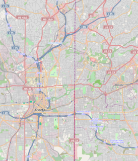
Marietta Street Artery (formerly designated as "Bellwood") is an officially defined neighborhood of the city of Atlanta, Georgia, [1] part of the West Midtown area of Atlanta, also known as the "Westside." [2]

Atlanta Capital of Georgia, United States

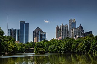
Atlanta is the capital and most populous city in the U.S. state of Georgia. With an estimated 2017 population of 486,290, it is also the 38th most-populous city in the United States. The city serves as the cultural and economic center of the Atlanta metropolitan area, home to 5.8 million people and the ninth-largest metropolitan area in the nation. Atlanta is the seat of Fulton County, the most populous county in Georgia. A small portion of the city extends eastward into neighboring DeKalb County.

Georgia (U.S. state) State of the United States of America

Georgia is a state in the Southeastern United States. It began as a British colony in 1733, the last and southernmost of the original Thirteen Colonies to be established. Named after King George II of Great Britain, the Province of Georgia covered the area from South Carolina south to Spanish Florida and west to French Louisiana at the Mississippi River. Georgia was the fourth state to ratify the United States Constitution, on January 2, 1788. In 1802–1804, western Georgia was split to the Mississippi Territory, which later split to form Alabama with part of former West Florida in 1819. Georgia declared its secession from the Union on January 19, 1861, and was one of the original seven Confederate states. It was the last state to be restored to the Union, on July 15, 1870. Georgia is the 24th largest and the 8th most populous of the 50 United States. From 2007 to 2008, 14 of Georgia's counties ranked among the nation's 100 fastest-growing, second only to Texas. Georgia is known as the Peach State and the Empire State of the South. Atlanta, the state's capital and most populous city, has been named a global city. Atlanta's metropolitan area contains about 55% of the population of the entire state.

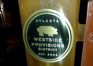
West Midtown, also known as Westside, is a colloquial area, comprising many historical neighborhoods located in Atlanta, Georgia. Once largely industrial, West Midtown is now the location of urban lofts, art galleries, live music venues, retail and restaurants.

Contents

The neighborhood consists of Marietta Street and the city blocks immediately to the east and west of it, stretching from 8th Street NW on the north to North Avenue NW on the south. It is bordered by the neighborhoods of Home Park on the north, Georgia Tech on the east, downtown Atlanta on the south, and English Avenue on the west. [3]

Marietta Street

Marietta Street is a historic street in Downtown Atlanta. The street leads from Atlanta towards the town of Marietta, as its name indicates. It begins as one of the five streets intersecting at Five Points, leading northwest, forming the southern border of Downtown's Fairlie-Poplar district, continuing through Downtown's Luckie Marietta district, then entering West Midtown's Marietta Street Artery neighborhood, until terminating at its junction with West Marietta St., Brady Ave., and 8th St.

City block central element of urban planning and urban design; smallest area that is surrounded by streets

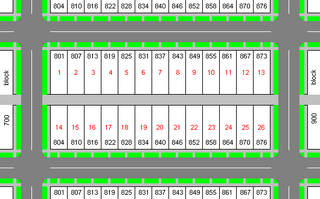
A city block, urban block or simply block is a central element of urban planning and urban design.

North Avenue (Atlanta) street in Atlanta, Georgia

North Avenue is a major avenue in Atlanta, Georgia that divides Downtown Atlanta from Midtown Atlanta. North Avenue stretches continuously in Atlanta from Candler Park in the east, across Interstate 75 & Interstate 85, along the southern boundary of the Georgia Institute of Technology, to Joseph E. Lowery Boulevard just southwest of Georgia Tech, where it ends. North Avenue passes through the neighborhoods of Poncey-Highland, Old Fourth Ward, and Midtown Atlanta.

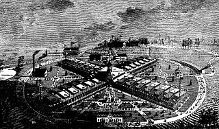
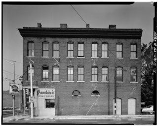
The neighborhood consists of many former industrial and warehouse properties which have been transformed into lofts, galleries, theaters, shops, restaurants, and coffee shops.

Factory facility where goods are made, or processed

A factory or manufacturing plant is an industrial site, usually consisting of buildings and machinery, or more commonly a complex having several buildings, where workers manufacture goods or operate machines processing one product into another.

Warehouse commercial storage building for goods in transit

A warehouse is a building for storing goods. Warehouses are used by manufacturers, importers, exporters, wholesalers, transport businesses, customs, etc. They are usually large plain buildings in industrial parks on the outskirts of cities, towns or villages.

Renovation process of improving a structure

Renovation is the process of improving a broken, damaged, or outdated structure. Renovations are typically either commercial or residential. Additionally, renovation can refer to making something new, or bringing something back to life and can apply in social contexts. For example, a community can be renovated if it is strengthened and revived.

History

The area began as an industrial area along the railroad line northwest from Atlanta even before the American Civil War — the Western and Atlantic Railroad line was completed in 1837. In 1881 the International Cotton Exposition was held at the north end of the corridor, for which the Exposition Cotton Mills were built. Mule-pulled trolleys brought workers starting in 1882, and these became electrified in 1894. [4] The area continued as an industrial and warehouse area, though the commercial strip along Marietta Street suffered with suburbanization starting in the 1960s. In the 1990s, several adaptive reuse projects kicked off (Hasting's Seed Company, The Carriage Works, King Plow Arts Center, and the Allied Warehouse #2), signaling the renaissance of the area. [5]

American Civil War Civil war in the United States from 1861 to 1865

The American Civil War was a civil war fought in the United States from 1861 to 1865, between the North and the South. The most studied and written about episode in U.S. history, the Civil War began primarily as a result of the long-standing controversy over the enslavement of black people. War broke out in April 1861 when secessionist forces attacked Fort Sumter in South Carolina shortly after Abraham Lincoln had been inaugurated as the President of the United States. The loyalists of the Union in the North proclaimed support for the Constitution. They faced secessionists of the Confederate States in the South, who advocated for states' rights to uphold slavery.

Western and Atlantic Railroad railway line

The Western & Atlantic Railroad of the State of Georgia (W&A) is a government-owned railroad and is currently leased by CSX, which CSX operates in the Southeastern United States from Atlanta, Georgia, to Chattanooga, Tennessee.

International Cotton Exposition

International Cotton Exposition (I.C.E) was a world's fair held in Atlanta, Georgia, from October 5 to December 31 of 1881. The location was along the Western & Atlantic Railroad tracks near the present-day King Plow Arts Center development in the West Midtown area. It planned to show the progress made since the city's destruction during the Battle of Atlanta and new developments in cotton production. It demonstrated the rebirth of Atlanta and the South by announcing an end to the Reconstruction Era and the sectional hostilities that had plagued the nation for several decades.

Bellwood was annexed to the city of Atlanta in 1897. [6] In January 1913 the Bellwood Viaduct was opened, allowing car and foot traffic to cross the railroad line parallel to Marietta Street to the west side of the city via Bellwood avenue (now Donald Lee Hollowell Pkwy.). [7] The neighborhood of Bellwood was officially renamed Marietta Street Artery in the 2000s.

Annexation acquisition of a states territory by another state

Annexation is the administrative action and concept in international law relating to the forcible acquisition of one state's territory by another state. It is generally held to be an illegal act. It is distinct from conquest, which refers to the acquisition of control over a territory involving a change of sovereignty, and differs from cession, in which territory is given or sold through treaty, since annexation is a unilateral act where territory is seized and held by one state. It usually follows military occupation of a territory.

Historic districts

The Artery area contains or is adjacent to the following NRHP-listed historic districts:

National Register of Historic Places federal list of historic sites in the United States

The National Register of Historic Places (NRHP) is the United States federal government's official list of districts, sites, buildings, structures, and objects deemed worthy of preservation for their historical significance. A property listed in the National Register, or located within a National Register Historic District, may qualify for tax incentives derived from the total value of expenses incurred preserving the property.

Historic buildings

Besides the historic buildings in the historic districts mentioned, the neighborhood also includes the following NRHP-listed buildings:

Related Research Articles

Pearl District, Portland, Oregon Neighborhood in Portland, Oregon, United States

The Pearl District is an area of Portland, Oregon, formerly occupied by warehouses, light industry and railroad classification yards and now noted for its art galleries, upscale businesses and residences. The area has been undergoing significant urban renewal since the mid-1980s when it was reclassified as mixed use from industrial, including the arrival of artists, the removal of a viaduct and construction of the Portland Streetcar. It now mostly consists of high-rise condominiums and warehouse-to-loft conversions.

Midtown Atlanta Neighborhoods of Atlanta in Fulton County, Georgia, United States

Midtown Atlanta, or Midtown, is a high-density commercial and residential neighborhood of Atlanta, Georgia. The exact geographical extent of the area is ill-defined due to differing definitions used by the city, residents, and local business groups. However, the commercial core of the area is anchored by a series of high-rise office buildings, condominiums, hotels, and high-end retail along Peachtree Street between North Avenue and 17th Street. Midtown, situated between Downtown to the south and Buckhead to the north, is the second-largest business district in Metro Atlanta. In 2011, Midtown had a resident population of 41,681 and a business population of 81,418.

The American city of Atlanta, Georgia is divided into 242 neighborhoods officially defined by the city. These "neighborhoods" are a mix of traditional neighborhoods; subdivisions or groups of subdivisions; and parts of core areas such as Downtown and Midtown.

The Neighborhood Planning Unit is a neighborhood-scale governmental structure used in the city of Atlanta, Georgia.

Westview, Atlanta CDP in Georgia, United States

Westview is a historic intown neighborhood located in southwest Atlanta, Georgia. It is named for the Westview Cemetery that borders the neighborhood to the northwest. The neighborhood is made up of a mixture of architectural styles including Arts & Crafts bungalows, Four-Squares, Tudors, Minimal Traditional houses, and Ranch style houses.

Ponce de Leon Avenue road in Georgia, USA

Ponce de Leon Avenue, often simply called Ponce, provides a link between Atlanta, Decatur, Clarkston, and Stone Mountain, Georgia. It was named for Ponce de Leon Springs, in turn from explorer Juan Ponce de León, but is not pronounced as in Spanish. Several grand and historic buildings are located on the avenue.

The King Plow Arts Center is a commercial, performing, and visual arts center located on Marietta Street in the Marietta Street Artery district of West Midtown, Atlanta. King Plow is the largest center of its kind in the city. King Plow is also a popular music venue for concerts and live music shows in Atlanta.

Howell Interlocking Historic District Area in West Midtown, Atlanta where four railroad lines converge

Howell Interlocking Historic District is the area in West Midtown, Atlanta where four railroad lines converge. It is adjacent to the Marietta Street Artery neighborhood, an area rich in industrial history, as an original industrial district built along Atlanta's first railway line (1837).

Southern Railway North Avenue Yards Historic District

The Southern Railway North Avenue Yards, now repurposed as the NorthYards business park, is located just west of the railway line northwest from downtown Atlanta, south of the Marietta Street Artery neighborhood, rich in industrial history. The Yards represent a microcosm in changes in American railroads over the course of the 20th century.

Means Street Historic District

The Means Street Historic District in the Marietta Street Artery district of Atlanta consists of historic, mostly 19th and early 20th century warehouse and industrial buildings now converted to office space along one block of Means St. between Bankhead and Ponders Aves. Means Street was named for landowner Alexander Means and was plotted in 1869. Warehouses were built in this early industrial corridor, then known as Bellwood, along the railroad line. Mule-pulled trolleys brought workers starting in 1882, and these became electrified in 1894.

North Buckhead is a neighborhood in the Buckhead district, at the northern edge of the city of Atlanta, Georgia, and is one of Atlanta's most affluent neighborhoods.

Blandtown is a neighborhood of the West Midtown area of Atlanta, Georgia. It is located along either side of Huff Road from Howell Mill Road west to Marietta Blvd. It was one of the first black settlements around Atlanta after the Civil War. As a community it declined from the 1950s through 1990s and now forms part of the West Midtown area, a rapidly developing part of Atlanta known for its home furnishings stores, new apartment and condo complexes, restaurants and bars.

Westside Provisions human settlement in Atlanta, Georgia, United States of America

Westside Provisions is a mixed use neighborhood located in the West Midtown area of Atlanta, Georgia, United States.

The King Plow/Railroad Historic District is a proposed historic district in Midtown West, Atlanta, Georgia. Creation of the district was approved at the state level in 2001 but it has not yet received national certification.

The Exposition Cotton Mills were cotton mills located in what is now the West Midtown area of Atlanta at the upper end of the Marietta Street Artery, an area rich with industrial heritage architecture. They were built for the International Cotton Exposition of 1881 and were demolished in 1952. A warehouse and distribution center now occupy the site.

Tuxedo Park is a neighborhood of Atlanta in the Buckhead area of the city. The area is NRHP-listed.

The Huff House was for decades the oldest house in the city of Atlanta. It was located at the northeast corner of Huff Road and Ellsworth Industrial Ave. at 1133 Huff Road NW in Blandtown, part of what is today West Midtown, overlooking the site of the Battle of Peachtree Creek. It was the family home of Sara Huff, the author of the memoir My 80 Years in Atlanta. Jeremiah Huff built the house of pine and brick in 1854 or 1855 over the remnants of an 1830s log cabin. It was razed in 1954 to make way for the Rushton Toy Factory building. Perennial Properties bought the factory site in 2006, demolished the factory in 2008, and the Apex West Midtown residential development is now located at the site.

Piedmont Avenue (Atlanta)

Piedmont Avenue is a major thoroughfare in Atlanta, beginning in Downtown Atlanta and ending at its continuation as Piedmont Road just before crossing under Interstate 85. Along the way, Piedmont Avenue passes through Midtown Atlanta where several historic properties are located on the street.

References

Coordinates: 33°46′28″N84°24′22″W / 33.774311°N 84.405998°W / 33.774311; -84.405998