The River Severn, at 220 miles (354 km) long, is the longest river in Great Britain. It is also the river with the most voluminous flow of water by far in all of England and Wales, with an average flow rate of 107 m3/s (3,800 cu ft/s) at Apperley, Gloucestershire. It rises in the Cambrian Mountains in mid Wales, at an altitude of 2,001 feet (610 m), on the Plynlimon massif, which lies close to the Ceredigion/Powys border near Llanidloes. The river then flows through Shropshire, Worcestershire and Gloucestershire. The county towns of Shrewsbury, Worcester and Gloucester lie on its course.

Cleobury Mortimer is a market town and civil parish in south-east Shropshire, England, which had a population of 3,036 at the 2011 census. It was granted a market charter by King Henry III in 1226.
Frankwell is a district of the town of Shrewsbury, in Shropshire, England. It lies adjacent to the River Severn, to the northwest of the town centre, and is one of Shrewsbury's oldest suburbs. The main road running through the area is also called Frankwell.

The English county of Shropshire has a fairly large railway network, with 19 National Rail stations on various national lines; there are also a small number of heritage and freight lines, including the famous heritage Severn Valley Railway running along its eastern border with Worcestershire.

The River Perry is a river in Shropshire, England. It rises near Oswestry and flows south to meet the River Severn above Shrewsbury. Along its 24 miles (39 km) length, its level drops by some 320 feet (95 m). The channel has been heavily engineered, both to enable water mills to be powered by it, and to improve the drainage of the surrounding land. There were at least seven corn mills in the 1880s, and the last one remained operational until 1966. The middle section of the river crosses Baggy Moor, where major improvements were made in 1777 to drain the moor. The scheme was one of the largest to enclose and improve land in North Shropshire, and the quality of the reclaimed land justified the high cost. A section of the river bed was lowered in the 1980s, to continue the process.

St George's Bridge was a bridge over the River Severn in Shrewsbury, England; so named as it was close to the medieval St George's Hospital. It connected Frankwell, an old suburb of the town, to the town centre via Mardol. The gate on the town side was called Mardol Gate and is located where the Mardol Quay Gardens are. The gate on the other side was called Welsh Gate or St George's Gate. The bridge, sometimes now known as the Old Welsh Bridge, was demolished in 1795 and was replaced with the Welsh Bridge.

The Welsh Bridge is a masonry arch viaduct in the town of Shrewsbury, England, which crosses the River Severn. It connects Frankwell with the town centre. It is a Grade II* listed building.
The town of Shrewsbury in Shropshire, England, has a history that extends back at least as far as the year 901, but it could have been first settled earlier. During the early Middle Ages, the town was a centre of the wool trade, and this was a peak in its importance. During the Industrial Revolution, comparatively little development took place in the town, although it did serve as a significant railway town after the development of rail transport in the area. The town today retains much of its historic architecture.
The Shrewsbury Canal was a canal in Shropshire, England. Authorised in 1793, the main line from Trench to Shrewsbury was fully open by 1797, but it remained isolated from the rest of the canal network until 1835, when the Birmingham and Liverpool Junction Canal built the Newport Branch from Norbury Junction to a new junction with the Shrewsbury Canal at Wappenshall. After ownership passed to a series of railway companies, the canal was officially abandoned in 1944; many sections have disappeared, though some bridges and other structures can still be found. There is an active campaign to preserve the remnants of the canal and to restore the Norbury to Shrewsbury line to navigation.

Shrewsbury railway station serves the town of Shrewsbury, in Shropshire, England. Built in 1848, it was designated a grade II listed building in 1969. Many services starting at or passing through the station are bound for Wales, and it is a key hub for its operator, Transport for Wales; services are also provided by West Midlands Railway.
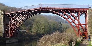
The Iron Bridge is a cast iron arch bridge that crosses the River Severn in Shropshire, England. Opened in 1781, it was the first major bridge in the world to be made of cast iron. Its success inspired the widespread use of cast iron as a structural material, and today the bridge is celebrated as a symbol of the Industrial Revolution.

Montford Bridge is a village and bridge. The village is in Shropshire, England, UK. The bridge is in that village. It lies on the River Severn and is close to the town of Shrewsbury.

Cound is a village and civil parish on the west bank of the River Severn in the English county of Shropshire, about 7 miles south east of the county town Shrewsbury. Once a busy and industrious river port Cound has now reverted to a quiet rural community and dormitory village, for commuters to the commercial centres of Shrewsbury and Telford.
Coleham is a district of the town of Shrewsbury in Shropshire, England. It is located just south, over the River Severn, from Shrewsbury town centre.
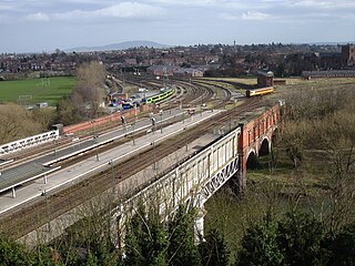
Severn Bridge Junction is the area of railway lines just south east of Shrewsbury railway station, in Shropshire, England. It is controlled by a mechanical interlocked signal box of the same name, which is the largest operational mechanical signal box in the world. The Network Rail signalling area code is 'SBJ.'

Mythe Bridge carries the A438 road across the River Severn at Tewkesbury. It is a cast-iron arch bridge spanning 170 feet (52 m) and 24 feet (7.3 m) wide, designed by Thomas Telford and completed in April 1826. It is a Grade II* listed structure.

Bewdley Bridge is a three-span masonry arch bridge over the River Severn at Bewdley, Worcestershire, designed by civil engineer Thomas Telford. The two side spans are each 52 feet (16 m), with the central span 60 feet (18 m). The central arch rises 18 feet (5.5 m). Smaller flood arches on the bank bridge the towpath. The bridge is 27 feet (8.2 m) wide.

Shrewsbury is a market town, civil parish and the county town of Shropshire, England. It is sited on the River Severn, 33 miles (53 km) northwest of Wolverhampton, 15 miles (24 km) west of Telford, 31 miles (50 km) southeast of Wrexham and 53 miles (85 km) north of Hereford. At the 2021 census, the parish had a population of 76,782.

John Carline was an 18th-century English bridge-builder. Both his son (1758-1834) and grandson (1792-1862) continued the name - the former focussing on churches and church monuments but also building bridges.
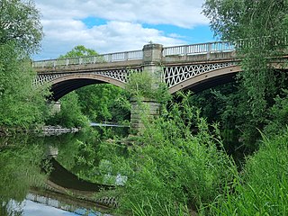
Belvidere Bridge is a cast iron arch railway bridge in Shrewsbury, western England, built for the Shrewsbury and Birmingham Railway in 1849. It carries the modern Wolverhampton to Shrewsbury railway line over the River Severn and is a grade II* listed building.