List of crossings of the River Severn

Last updated

Motorway crossings over the River Severn
Aerial view of M50 Motorway Viaduct - geograph org uk - 300101.jpg
Queenhill Viaduct (M50 motorway)

This is a list of crossings of the River Severn in Great Britain (including bridges, tunnels, ferries and fords), in order from source to mouth.

Contents

The Severn has historically been a very important and busy river, and has been bridged throughout history. The bridges that stand today are often of great historical and/or engineering interest. For example, the world's first iron bridge, The Iron Bridge, built from cast iron, crosses the River Severn at Ironbridge Gorge. The Iron Bridge is one of three bridges on the River Severn that are listed as grade I structures, including Bewdley Bridge and the Severn Bridge, which was opened in 1966. In total, 31 bridges that cross the River Severn are listed, either grade I, II* or II. Four bridges are scheduled monuments, including The Iron Bridge, which are nationally important archaeological bridges.

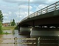
Many reaches of the Severn are prone to severe flooding, prompting the design of some unique bridges to cope with this.

There were historically also ferry crossings on the tidal river at:


Crossings

Key to heritage status
StatusCriteria [1]
IGrade I listed. Bridge of exceptional interest, sometimes considered to be internationally important
II*Grade II* listed. Particularly important bridge of more than special interest
IIGrade II listed. Bridge of national importance and special interest
SM
Scheduled monument. Nationally important archaeological bridge.

In order, moving downstream:

CrossingDate Coordinates Heritage
status
LocalityNotesImage
The source of the River Severn 52°29′36″N3°44′04″W / 52.49347°N 3.73458°W / 52.49347; -3.73458 (The source of the River Severn) - Plynlimon Included for completeness The source of the River Severn.jpg
First culvert on the Severn 52°29′19″N3°43′36″W / 52.48855°N 3.72676°W / 52.48855; -3.72676 (First culvert on the Severn) - Hafren Forest Provides Forestry Access.

Also carries the Severn Way long-distance footpath from left bank to right bank when heading downstream.

The first Severn crossing - geograph.org.uk - 1126088.jpg
First footbridge on the Severn 52°29′13″N3°43′20″W / 52.48681°N 3.72227°W / 52.48681; -3.72227 (First footbridge on the Severn) - Hafren Forest Carries the Severn Way long-distance footpath from right bank to left bank when heading downstream. Footbridge across the Severn - geograph.org.uk - 1124143.jpg
Blaen Hafren Falls culvert 52°28′53″N3°42′58″W / 52.48151°N 3.71618°W / 52.48151; -3.71618 (Blaen Hafren Falls Culvert) - Hafren Forest Provides forestry access.

Also carries Severn Way long-distance footpath from left bank to right bank when heading downstream.

River Severn, Forestry road pipe bridge, Blaen Hafren Falls - geograph.org.uk - 691252.jpg
Second footbridge on the Severn1992 52°28′22″N3°42′05″W / 52.47276°N 3.70141°W / 52.47276; -3.70141 (Second footbridge on the Severn) - Hafren Forest 
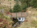
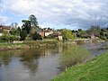
Previously known as the 'First Bridge on the Severn'. Opened May 1992 by Lady Hooson, wife of Emlyn Hooson, Baron Hooson. Also carries Severn Way long-distance footpath from right bank to left bank when heading downstream. The Wye Valley Walk long-distance footpath starts here. Footbridge at the meeting of the Severn Way and the Wye Valley Walk - geograph.org.uk - 772153.jpg
Rhyd-y-Benwch Ford 52°28′06″N3°41′05″W / 52.46847°N 3.68475°W / 52.46847; -3.68475 (Rhyd-y-Benwch Footbridge) -Hafren ForestFirst ford on the Severn. Provides forestry access. Ford across the Severn at Rhyd-y-benwch - geograph.org.uk - 1122443.jpg
Rhyd-y-Benwch Footbridge1997 52°28′02″N3°40′54″W / 52.46716°N 3.68180°W / 52.46716; -3.68180 (Rhyd-y-Benwch Footbridge) -Hafren Forest River Severn, Wooden Footbridge Rhyd-y-Benwch - geograph.org.uk - 808231.jpg
Cwm Ricket Bridge 52°27′59″N3°40′42″W / 52.46636°N 3.67824°W / 52.46636; -3.67824 (Cwm Ricket Bridge) -Cwm RicketFirst road bridge on the river. Weight limit of 12.5T. River Severn, Forestry road bridge, Cwm Ricket - geograph.org.uk - 809677.jpg
Cwm Ricket Pipe Bridge 52°27′59″N3°40′40″W / 52.46632°N 3.67775°W / 52.46632; -3.67775 (Cwm Ricket Pipe Bridge) -Cwm Ricket
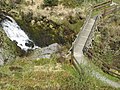
Previously known as Irish Bridge and Paddy's Bridge. Provides forestry access, as nearby Cwm Ricket Bridge has a 12.5T weight limit. With high water, it becomes a ford. River Severn, Forestry Road Pipe Bridge, Cwm Ricket - geograph.org.uk - 678604.jpg
Severn Break Its Neck Footbridge1995 52°28′00″N3°40′30″W / 52.46665°N 3.67500°W / 52.46665; -3.67500 (Severn Break Its Neck Footbridge) -Rhyd-yr-OnnenProvides view of waterfall and gorge. River Severn,Wooden footbridge,Break-its-neck-falls - geograph.org.uk - 812439.jpg
Rhyd-yr-Onnen Footbridge 52°27′55″N3°39′51″W / 52.46541°N 3.66407°W / 52.46541; -3.66407 (Rhyd-yr-Onnen Footbridge) -Rhyd-yr-Onnen River Severn,Wooden footbridge,Rhyd-yr-Onnen - geograph.org.uk - 814670.jpg
Hafodfeddgar Farm Bridge 52°27′32″N3°39′25″W / 52.45902°N 3.65694°W / 52.45902; -3.65694 (Hafodfeddgar Farm Bridge) -HafodfeddgarProvides farm access. River Severn,Hafodfeddgar farm bridge. - geograph.org.uk - 814688.jpg
Geufron Farm Bridge 52°27′23″N3°38′50″W / 52.45634°N 3.64720°W / 52.45634; -3.64720 (Geufron Farm Bridge) -GeufronProvides farm access. River Severn,Geufron farm bridge. - geograph.org.uk - 820672.jpg
Tynwtra Footbridge 52°27′14″N3°38′11″W / 52.45396°N 3.63637°W / 52.45396; -3.63637 (Tynwtra Footbridge) -Tan HinonHas been dismantled - only abuttments remain. River Severn, old bridge supports,Tan Hinon - geograph.org.uk - 820717.jpg
Glynhafren Farm Bridge 52°26′55″N3°37′41″W / 52.44850°N 3.62806°W / 52.44850; -3.62806 (Glynhafren Farm Bridge) -GlynhafrenProvides farm access. River Severn,Glynhafren farm bridge. - geograph.org.uk - 828602.jpg
Old Hall Ford 52°26′53″N3°36′52″W / 52.44819°N 3.61448°W / 52.44819; -3.61448 (Old Hall Ford) -Old HallProvides farm access. Ford across the Severn-Hafren - geograph.org.uk - 968405.jpg
Glanhafren Bridge1972 52°26′53″N3°36′27″W / 52.44804°N 3.60761°W / 52.44804; -3.60761 (Glanhafren Bridge) -Old HallFirst tarmac-surfaced road bridge on the Severn. River Severn,Glynhafren road bridge. - geograph.org.uk - 829942.jpg
Nantyrhebog Footbridge 52°27′02″N3°34′47″W / 52.45068°N 3.57978°W / 52.45068; -3.57978 (Nantyrhebog Footbridge) -Glan-y-Nant River Severn,Nantythebog footbridge. - geograph.org.uk - 836238.jpg
Cancoed Footbridge 52°26′35″N3°33′19″W / 52.44294°N 3.55540°W / 52.44294; -3.55540 (Cancoed Footbridge) -Glan-y-Nant River Severn,Cancoed footbridge. - geograph.org.uk - 836259.jpg
Felindre Bridge1848 52°26′35″N3°33′19″W / 52.44294°N 3.55540°W / 52.44294; -3.55540 (Felindre Bridge) IIMount SevernDesigned by Thomas Penson, masonry arch bridge Felindre Bridge - geograph.org.uk - 294112.jpg
Colonel's Bridge1975 52°26′41″N3°32′54″W / 52.44465°N 3.54839°W / 52.44465; -3.54839 (Colonel's Bridge) - Llanidloes Timber bridge also known as Pen-y-Green Bridge, named after Colonel Davies-Jenkins River Severn,Colonels timber farm access bridge. - geograph.org.uk - 842329.jpg
Short Bridge1850 52°26′57″N3°32′33″W / 52.44911°N 3.54242°W / 52.44911; -3.54242 (Short Bridge) IILlanidloesDesigned by Thomas Penson River Severn,Short bridge.Llanidloes. - geograph.org.uk - 855124.jpg
Long Bridge1826 52°27′04″N3°32′21″W / 52.45104°N 3.53923°W / 52.45104; -3.53923 (Long Bridge) IILlanidloesDesigned by Thomas Penson, carried the B4518 road. Longbridge, Llanidloes - geograph.org.uk - 622391.jpg
Morfodion Farm Bridge1859 52°27′26″N3°30′32″W / 52.45735°N 3.50879°W / 52.45735; -3.50879 (Morfodion Farm Bridge) -Llanidloes
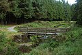
Timber bridge built as part of the Llanidloes and Newtown Railway, later becoming part of the Cambrian Railway's route from Newtown to Builth Wells; the railway was closed on 31 December 1962. Now used as a farm access bridge. River Severn,wooden disused railway bridge. - geograph.org.uk - 695172.jpg
Dolwen Bridge1926 52°27′19″N3°28′39″W / 52.45541°N 3.47737°W / 52.45541; -3.47737 (Dolwen Bridge) -Upper Penrhuddlan River Severn,Dolwen Bridge. - geograph.org.uk - 902232.jpg
Llandinam Bridge 1843 52°29′11″N3°26′13″W / 52.48645°N 3.43698°W / 52.48645; -3.43698 (Llandinam Bridge) II* Llandinam Iron arch bridge designed by Thomas Penson, the first of its type in Montgomeryshire. River Severn, Llandinam bridge - geograph.org.uk - 711424.jpg
Caersws Railway Bridge 52°30′50″N3°25′43″W / 52.51392°N 3.42867°W / 52.51392; -3.42867 (Caersws Railway Bridge) - Caersws Timber bridge carries the Cambrian Line. Railway bridge over the Severn - geograph.org.uk - 481462.jpg
Caersws Bridge1821 52°30′52″N3°25′38″W / 52.51439°N 3.42713°W / 52.51439; -3.42713 (Caersws Bridge) IICaerswsTriple span arch bridge designed by Thomas Penson. Carries the A470 road. River Severn,Caersws road bridge. - geograph.org.uk - 904807.jpg
Festival Footbridge1951 52°31′17″N3°23′21″W / 52.52130°N 3.38919°W / 52.52130; -3.38919 (Festival Footbridge) - Aberhafesp Suspension footbridge built by David Rowell & Co. River Severn, Aberhafesp festival footbridge - geograph.org.uk - 904844.jpg
Penstrowed Railway Bridge 52°30′33″N3°21′55″W / 52.50905°N 3.36515°W / 52.50905; -3.36515 (Penstrowed Railway Bridge) -PenstrowedCarries the Cambrian Line. River Severn, Penstrowed railway bridge - geograph.org.uk - 672210.jpg
Glanhafren Hall Railway Bridge 52°30′21″N3°21′08″W / 52.50594°N 3.35230°W / 52.50594; -3.35230 (Glanhafren Hall Railway Bridge) -Glanhafren HallCarries the Cambrian Line. River Severn,Glanhafren railway bridge. - geograph.org.uk - 905640.jpg
Dolerw Park Footbridge1973 52°30′54″N3°19′12″W / 52.51497°N 3.31998°W / 52.51497; -3.31998 (Dolerw Park Footbridge) - Newtown, Powys Suspension footbridge designed by Mott, Hay and Anderson River Severn,Dolerw footbridge. - geograph.org.uk - 905656.jpg
The Long Bridge1827 52°31′01″N3°19′00″W / 52.51707°N 3.31675°W / 52.51707; -3.31675 (Long Bridge) IINewtownDesigned by Thomas Penson. River Severn,Long road bridge. - geograph.org.uk - 908038.jpg
Halfpenny Footbridge1972 52°30′56″N3°18′48″W / 52.51548°N 3.31325°W / 52.51548; -3.31325 (Halfpenny Footbridge) -NewtownFourth bridge on this site, the first dating from 1830 River Severn, Halfpenny footbridge - geograph.org.uk - 914133.jpg
Newtown Bypass Bridge1993 52°30′53″N3°18′34″W / 52.51482°N 3.30933°W / 52.51482; -3.30933 (Newtown Bypass Bridge) -NewtownCarries the B4568 road, Cambrian Way. River Severn, Newtown bypass road bridge - geograph.org.uk - 914147.jpg
Cilgwrgan Bridge1862 52°31′53″N3°15′50″W / 52.5314°N 3.2638°W / 52.5314; -3.2638 (Cilgwrgan Bridge) II Aberbechan 3-span brickwork arch bridge River Severn, Cilgwrgan Bridge - geograph.org.uk - 721176.jpg
Abermule Bypass Bridge1975 52°32′28″N3°14′39″W / 52.54098°N 3.24416°W / 52.54098; -3.24416 (Abermule Bypass Bridge) - Abermule River Severn,Abermule bypass bridge - geograph.org.uk - 923427.jpg
Brynderwen Bridge1852 52°32′52″N3°14′12″W / 52.54774°N 3.23657°W / 52.54774; -3.23657 (Brynderwen Bridge) II*AbermuleDesigned by Thomas Penson, built by the Brymbo Company of Wrexham. Bridge is inscribed: THIS SECOND IRON BRIDGE CONSTRUCTED IN THE COUNTY OF MONTGOMERY WAS ERECTED IN THE YEAR 1852. Abermule "The Second Ironbridge", looking upstream - geograph.org.uk - 659374.jpg
Fron Footbridge1926 52°34′05″N3°12′26″W / 52.56815°N 3.20727°W / 52.56815; -3.20727 (Fron Footbridge) -Plas MeredyddSuspension footbridge by David Rowell & Co River Severn, Fron footbridge - geograph.org.uk - 923467.jpg
Caerhowel Bridge 1858 52°34′30″N3°11′13″W / 52.57509°N 3.18681°W / 52.57509; -3.18681 (Caer Howell Bridge) IITrwstllewelynDesigned by Thomas Penson. Bridge is narrow, with traffic lights. Perfection in cast iron - geograph.org.uk - 644058.jpg
Cil-cewydd Bridge1861 52°37′45″N3°08′32″W / 52.62906°N 3.14230°W / 52.62906; -3.14230 (Cil-cewydd Bridge) IICil-cewyddDesigned by Thomas Penson. River Severn,Cilcewydd road bridge - geograph.org.uk - 926213.jpg
Cil-cewydd Railway Bridge 52°37′47″N3°08′30″W / 52.62964°N 3.14179°W / 52.62964; -3.14179 (Cil-cewydd Railway Bridge) -Cil-cewyddBuilt for Oswestry and Newtown Railway River Severn,Cilcewydd railway bridge. - geograph.org.uk - 926241.jpg
Leighton Bridge1872 52°39′18″N3°07′46″W / 52.65505°N 3.12958°W / 52.65505; -3.12958 (Leighton Bridge) II Welshpool Carries the B4381 road. The listing description is "Bridge over channel N of Severn Lodge". River Severn,Leighton road bridge. - geograph.org.uk - 931218.jpg
Buttington Railway Bridge 52°40′19″N3°06′57″W / 52.67185°N 3.11573°W / 52.67185; -3.11573 (Buttington Railway Bridge) -Welshpool River Severn,Buttington railway bridge. - geograph.org.uk - 935219.jpg
Buttington Bridge1872 52°40′21″N3°06′58″W / 52.67253°N 3.11616°W / 52.67253; -3.11616 (Buttington Bridge) IIWelshpoolCast iron arch bridge, carries the A458 road. River Severn,Buttington road bridge - geograph.org.uk - 676661.jpg
Maginnis Bridge 52°41′47″N3°05′54″W / 52.6964°N 3.0983°W / 52.6964; -3.0983 (Maginnis Bridge) -Pool Quay River Severn,Maginnis farm bridge - geograph.org.uk - 935260.jpg
Llandrinio Bridge1775 52°44′45″N3°02′27″W / 52.74595°N 3.04085°W / 52.74595; -3.04085 (Llandrinio Bridge) II Llandrinio Stone arch bridge. Oldest surviving bridge on the river. Bridge is narrow with traffic lights. Llandrinio Bridge - geograph.org.uk - 205218.jpg
Crewgreen Bridge1947 52°44′08″N2°59′38″W / 52.73546°N 2.99390°W / 52.73546; -2.99390 (Crewgreen Bridge) - Crewgreen Built as a railway bridge but converted to a road bridge. Crosses from Wales to England. Bridge over the Severn - geograph.org.uk - 462436.jpg
Montford Bypass Bridge1992 52°43′51″N2°50′45″W / 52.73096°N 2.84589°W / 52.73096; -2.84589 (Montford Bypass Bridge) - Montford Carries the A5 road. Designed by Sir Owen Williams and Partners as part of the A5 Telford to Shrewsbury and A49 link improvement. River Severn, Montford Road bypass bridge - geograph.org.uk - 944755.jpg
Montford Bridge 1792 52°43′56″N2°50′33″W / 52.73221°N 2.84262°W / 52.73221; -2.84262 (Montford Bridge) IIMontford BridgeMasonry arch bridge by Thomas Telford. Former A5 route, now carried the B4380 road. River Severn, Montford Road bridge - geograph.org.uk - 944768.jpg
Frankwell Footbridge1979 52°42′38″N2°45′18″W / 52.71064°N 2.75501°W / 52.71064; -2.75501 (Frankwell Footbridge) - Frankwell, Shrewsbury Cable-stayed footbridge designed by Mott, Hay and Anderson Frankwell Footbridge, Shrewsbury - geograph.org.uk - 1307412.jpg
St George's Bridge 52°42′37″N2°45′24″W / 52.71028°N 2.75667°W / 52.71028; -2.75667 (St George's Bridge) -ShrewsburyDemolished in 1795 and replaced by the Welsh Bridge. It was also known as the Old Welsh Bridge. The-Old-Welsh-Bridge-Shrewsbury.jpg
Welsh Bridge 1795 52°42′36″N2°45′29″W / 52.71013°N 2.75807°W / 52.71013; -2.75807 (Welsh Bridge) II*Frankwell, Shrewsbury Severn River, Welsh Bridge.jpg
Porthill Bridge 1922 52°42′30″N2°45′49″W / 52.70842°N 2.76371°W / 52.70842; -2.76371 (Porthill Bridge) -ShrewsburySuspension footbridge by David Rowell & Co Porthill Bridge Shrewsbury.jpg
Kingsland Bridge 1881 52°42′16″N2°45′32″W / 52.70437°N 2.75895°W / 52.70437; -2.75895 (Kingsland Bridge) IIShrewsburyToll road bridge Kingsland BridgeCB.jpg
Greyfriars Footbridge1879 52°42′17″N2°44′56″W / 52.70467°N 2.74893°W / 52.70467; -2.74893 (Greyfriars Footbridge) - Coleham, Shrewsbury Wrought iron truss bridge Greyfriars Bridge 3724411 70078880.jpg
English Bridge 1927 52°42′24″N2°44′51″W / 52.70660°N 2.74748°W / 52.70660; -2.74748 (English Bridge) II*Shrewsbury
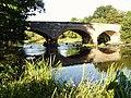
Designed by John Gwynn. Completely rebuilt in the 1920s using the original 1774 stone work, but the bridge was widened by 26 feet (7.9 m) and the gradient reduced; reopened on 26 October 1927. (The 1774 Bridge replaced the medieval East or Old Stone Bridge.) It carries the A458 road. English Bridge a.jpg
Shrewsbury Railway Station Bridge1838 52°42′38″N2°44′52″W / 52.71069°N 2.74782°W / 52.71069; -2.74782 (Shrewsbury Railway Station Bridge) - Shrewsbury station Designed by Robert Stephenson and Joseph Locke. River Severn, Shrewsbury railway station bridge - geograph.org.uk - 949038.jpg
Castle Walk Footbridge 1951 52°42′45″N2°44′38″W / 52.71250°N 2.74382°W / 52.71250; -2.74382 (Castle Walk Footbridge) -ShrewsburyThe first prestressed concrete balanced cantilever bridge in the UK Castle walk footbridge.jpg
Telford Way Bridge1964 52°43′21″N2°43′57″W / 52.72242°N 2.73255°W / 52.72242; -2.73255 (Telford Way Bridge) -ShrewsburyPrestressed concrete bridge. Designed by Scott Wilson Group, it carries the A5112 road. River Severn, Telford Way road bridge - geograph.org.uk - 984789.jpg
Shrewsbury Bypass Bridge1992 52°43′20″N2°42′24″W / 52.72236°N 2.70667°W / 52.72236; -2.70667 (Shrewsbury Bypass Bridge) -ShrewsburyCarries the A49 road. River Severn, Shrewsbury A49 bypass road bridge, upstream bridge of two bridges on bypass - geograph.org.uk - 984829.jpg
Shrewsbury Bypass Bridge1992 52°43′01″N2°42′17″W / 52.71701°N 2.70478°W / 52.71701; -2.70478 (Shrewsbury Bypass Bridge) -ShrewsburyCarries the A49 road. River Severn, Shrewsbury A49 bypass road bridge, downstream bridge of two bridges on bypass - geograph.org.uk - 984853.jpg
Belvidere Bridge 1848 52°42′30″N2°42′46″W / 52.70825°N 2.71271°W / 52.70825; -2.71271 (Belvidere Bridge) II*ShrewsburyDesigned by William Baker; carries the Wolverhampton to Shrewsbury Line. River Severn, Belvidere railway bridge - geograph.org.uk - 984878.jpg
Shrewsbury Bypass Bridge1992 52°41′39″N2°42′34″W / 52.69417°N 2.70942°W / 52.69417; -2.70942 (Shrewsbury Bypass Bridge) -ShrewsburyCarries the A5/A49. River Severn, Shrewsbury A5 bypass road bridge - geograph.org.uk - 984894.jpg
Atcham New Bridge1929 52°40′47″N2°40′53″W / 52.6798°N 2.6813°W / 52.6798; -2.6813 (Atcham New Bridge) - Atcham Designed by L G Mouchel Atcham Bridge - geograph.org.uk - 1674026.jpg
Atcham Bridge1776 52°40′46″N2°40′52″W / 52.67948°N 2.68124°W / 52.67948; -2.68124 (Atcham Bridge) II*AtchamMasonry arch viaduct designed by John Gwynn Old Atcham Bridge - geograph.org.uk - 5677.jpg
SM
Cressage Bridge1913 52°38′14″N2°36′06″W / 52.6371°N 2.6017°W / 52.6371; -2.6017 (Cressage Bridge) - Cressage Carries the B4380 road. Reinforced concrete bridge by L G Mouchel River Severn, Cressage road bridge - geograph.org.uk - 1001985.jpg
Buildwas Bridge1992 52°38′11″N2°31′32″W / 52.63642°N 2.52567°W / 52.63642; -2.52567 (Buildwas Bridge) - Buildwas Carries the A4169 road. Replaced a bridge previously built in 1796 by Thomas Telford River Severn, Buildwas road bridge - geograph.org.uk - 1006547.jpg
Ironbridge "A" Road Bridge (disused)1932 52°38′11″N2°30′47″W / 52.63637°N 2.51293°W / 52.63637; -2.51293 (Ironbridge "A" Road Bridge) - Ironbridge Coalbrookdale. Steel truss bridge providing access to Ironbridge Power Station River Severn, Ironbridge 'A' power station road bridge - geograph.org.uk - 1007781.jpg
Ironbridge "B" Road Bridge1963 52°37′59″N2°30′25″W / 52.63298°N 2.50683°W / 52.63298; -2.50683 (Ironbridge "B" Road Bridge) -IronbridgeCoalbrookdale. Prestressed concrete bridge providing access to Ironbridge Power Station River Severn, Ironbridge 'B' power station road bridge - geograph.org.uk - 1007836.jpg
Albert Edward Bridge 1864 52°37′50″N2°30′12″W / 52.63061°N 2.50333°W / 52.63061; -2.50333 (Albert Edward Bridge) IIDesigned by John Fowler; carries the remaining section of the Wellington to Craven Arms Railway Albert Edward Bridge.JPG
The Iron Bridge 1779 52°37′38″N2°29′08″W / 52.6273°N 2.4855°W / 52.6273; -2.4855 (The Iron Bridge) IIronbridge Arch bridge; the world's first cast iron bridge, built by Abraham Darby III, now foot access only. In the 1970s, major work was undertaken to restore the bridge, including an inverted concrete arch in the river bed to keep the abutments apart. Iron Bridge east side in February 2019 (cropped).jpg
SM
Free Bridge, Jackfield1909 52°37′35″N2°28′21″W / 52.62649°N 2.47259°W / 52.62649; -2.47259 (Free Bridge, Jackfield) II Jackfield The Free Bridge, which was also known as the Haynes Memorial Bridge, opened in 1909 by public subscription, it was the first toll-free crossing of the Ironbridge Gorge. The bridge was the first bridge in England constructed using reinforced concrete and was designed by L G Mouchel. The bridge became unsafe and was demolished in 1993 to make way for the new Jackfield Bridge.
Jackfield Bridge1994 52°37′35″N2°28′21″W / 52.62649°N 2.47259°W / 52.62649; -2.47259 (Jackfield Bridge) -Jackfield Cable-stayed bridge designed by Gifford & Partners, carrying the B4373 road. River Severn, Jackfield road bridge - geograph.org.uk - 1012790.jpg
Jackfield and Coalport Memorial Footbridge1922 52°37′11″N2°27′13″W / 52.61985°N 2.45369°W / 52.61985; -2.45369 (War Memorial Footbridge) - Coalport A steel truss footbridge Coalport Memorial Footbridge - geograph.org.uk - 855304.jpg
Coalport Bridge 1818 52°36′55″N2°26′31″W / 52.61537°N 2.44208°W / 52.61537; -2.44208 (Coalport Bridge) II*CoalportIron arch bridge, replaced a crossing built in 1777 Coalport br1.jpg
SM
Coalport Sewage Treatment Works Bridge 52°36′40″N2°25′56″W / 52.61115°N 2.43211°W / 52.61115; -2.43211 (Coalport Sewage Treatment Works Bridge) -CoalportBridge serving the Coalport Sewage Treatment Works, owned by Severn Trent Water River Severn, Severn Trent sewage treatment works bridge - geograph.org.uk - 1218166.jpg
Apley Park Bridge1905 52°34′55″N2°26′04″W / 52.5819°N 2.4345°W / 52.5819; -2.4345 (Apley Park Footbridge) -Suspension footbridge, designed and built by David Rowell & Co. This is a private road bridge for the Apley Park Estate, and is not a public footpath. Weight limit is 1 tonne, and only one vehicle allowed on the bridge at a time. Apley Bridge - geograph.org.uk - 681314.jpg
Severn Bridge, Bridgnorth1823 52°32′03″N2°24′58″W / 52.53413°N 2.41613°W / 52.53413; -2.41613 (Bridgnorth bridge) II Bridgnorth Originally medieval, but rebuilt in 1795 with improvements made Thomas Telford in 1823 Bridgnorth Bridge - geograph.org.uk - 1094939.jpg
Bridgnorth Bypass Bridge1985 52°31′39″N2°25′02″W / 52.52739°N 2.41721°W / 52.52739; -2.41721 (Bridgnorth bypass bridge) -BridgnorthA458 River Severn, Bridgnorth Bypass Road Bridge - geograph.org.uk - 1417957.jpg
Hampton Loade Water Treatment Works bridge1965 52°28′51″N2°22′31″W / 52.48092°N 2.37533°W / 52.48092; -2.37533 (Hampton Loade Water Treatment Works bridge) - Hampton Loade Bridge serving the Hampton Loade Water Treatment Works. The tubular welded blue arches are waterpipes that carry a small roadway suspended below. The bridge is owned by South Staffordshire Water. River Severn, Hampton Loade Waterworks Bridge - geograph.org.uk - 1417969.jpg
Hampton Loade Ferry <1600 52°28′34″N2°22′26″W / 52.47606°N 2.37391°W / 52.47606; -2.37391 (Hampton Loade Ferry) -Hampton LoadeThe only 'Reaction Cable' ferry in the UK. The most recent boat dated from 2004. It was 20 feet (6.1 m) by 9 feet (2.7 m) and carried up to 12 passengers plus the operator. Was operated by the Hampton Loade Community Trust at weekends during the summer provided the river level was suitable. Closed permanently in 2016. [2] Hampton Loade Ferry - 2004-07-24.jpg
Highley-Alveley Footbridge2006 52°27′10″N2°22′17″W / 52.45265°N 2.37136°W / 52.45265; -2.37136 (Highley-Alveley Footbridge) - Highley Replaced the Alveley Colliery Bridge, which was built in 1937 to take coal to Stourport Power Station. River Severn,Highley to Alveley footbridge - geograph.org.uk - 1658596.jpg
Upper Arley Ferry1331–1972 52°25′09″N2°20′51″W / 52.41920°N 2.34740°W / 52.41920; -2.34740 (Upper Arley Ferry) - Upper Arley Ancient ferry, replaced by the Arley footbridge Upper Arley village and the river Severn - geograph.org.uk - 2379.jpg
Arley footbridge1971 52°25′06″N2°20′45″W / 52.41820°N 2.34578°W / 52.41820; -2.34578 (Arley footbridge) -Upper ArleyTruss footbridge, replaced a vehicular ferry River Severn,Upper Arley footbridge.jpg
Victoria Bridge 1861 52°24′38″N2°20′41″W / 52.41048°N 2.34476°W / 52.41048; -2.34476 (Victoria Bridge, Worcestershire) II*Upper Arley.Cast iron arch designed by John Fowler. Carries the Severn Valley Railway. 43106 Victoria Bridge Severn Valley Railway.jpg
Elan aqueduct circa 1900 52°24′04″N2°19′53″W / 52.40117°N 2.33145°W / 52.40117; -2.33145 (Elan Valley Pipeline Bridge) - Trimpley Carries water from the Elan Valley at Rhayader to Birmingham. It is also known as the Elan Valley Pipeline Bridge River Severn,Bewdley Aqueduct - geograph.org.uk - 1712149.jpg
Dowles Bridge1864 52°23′07″N2°19′30″W / 52.38531°N 2.32495°W / 52.38531; -2.32495 (Dowles Bridge) -On the former Tenbury & Bewdley Railway; dismantled 1965, piers only remaining. Dowles Bridge.jpg
Bewdley Bridge 1798 52°22′35″N2°18′50″W / 52.37646°N 2.31390°W / 52.37646; -2.31390 (Bewdley Bridge) I Bewdley Multiple masonry arches, designed by Thomas Telford. Listed as "Severn Bridge Including Flanking Arches and Balustrade". Bewdley Bridge.jpg
Bewdley Bypass Bridge1987 52°21′59″N2°18′15″W / 52.36629°N 2.30411°W / 52.36629; -2.30411 (A456, Bewdley bypass) -BewdleyCarries the A456 road Bridge over to River Severn - geograph.org.uk - 1036375.jpg
Stourport Bridge1870 52°20′14″N2°16′59″W / 52.33713°N 2.28318°W / 52.33713; -2.28318 (Stourport bridge) II Stourport-on-Severn Single iron arch, replaced a 1775 bridge. Listed as "Bridge over River Severn" Severn River, Stourport Road Bridge (82).jpg
Holt Fleet Bridge 1828 52°16′05″N2°15′32″W / 52.26818°N 2.25889°W / 52.26818; -2.25889 (Holt Bridge) II Holt Fleet Cast iron trussed arch; designed by Telford, opened 1828 and strengthened with reinforced concrete in 1928. Identical design to Galton Bridge, Smethwick over canal (1829). Holt Fleet bridge - geograph.org.uk - 592544.jpg
Bevere Island Bridge1844 52°13′58″N2°14′21″W / 52.23282°N 2.23913°W / 52.23282; -2.23913 (Bevere Island Bridge) - Grimley Links island to East bank; not a full crossing. River Severn, Bevere Island Bridge.jpg
Sabrina Footbridge1992 52°11′40″N2°13′55″W / 52.19445°N 2.23205°W / 52.19445; -2.23205 (Sabrina footbridge) - Worcester Asymmetrical, cable-stayed bridge with one tower. The Sabrina Bridge, Worcester - geograph.org.uk - 280039.jpg
Worcester Railway Bridge1904 52°11′35″N2°13′47″W / 52.19310°N 2.22974°W / 52.19310; -2.22974 (Worcester railway bridge) II Worcester Iron truss. Listed as "Railway Bridge, Worcester". Carries the Cotswold Line over the river near Worcester Foregate Street station. Boats moored on River Severn by Le Vesinet Promenade - geograph.org.uk - 958317.jpg
Worcester Bridge1781 52°11′27″N2°13′35″W / 52.19083°N 2.22632°W / 52.19083; -2.22632 (Worcester A44 road bridge) II Worcester Multiple masonry arches designed by John Gwynn. Reconstructed in 1930. Carried the A44 Bridge over the River Severn at Worcester - geograph.org.uk - 31489.jpg
Worcester Cathedral FerryAncient 52°11′16″N2°13′22″W / 52.18785°N 2.22279°W / 52.18785; -2.22279 (Worcester Cathedral Ferry) - Worcester Also known as Priory Ferry. Operated every day till the 1950s. Service restarted in 1983. As of 2009, it is the only Rowing Ferry across the River Severn; it is operated by volunteers during the summer, every afternoon at weekends and bank holidays. Cropped image of Cathedral Ferry, Worcester.jpg
Diglis BridgeJune 2010 52°10′34″N2°13′29″W / 52.17624°N 2.22474°W / 52.17624; -2.22474 (Diglis Bridge) - Worcester Located just downstream of Diglis Island. Carrying pedestrians and Route 46 of the National Cycle Network [3] [4] River Severn, Diglis Bridge.jpg
Carrington Bridge1985 52°09′46″N2°13′04″W / 52.16290°N 2.21774°W / 52.16290; -2.21774 (Carrington Bridge) - Worcester Carrying the A4440 Southern Link Road [5] Carrington Bridge - geograph.org.uk - 1347948.jpg
Rhydd Ferry 52°06′17″N2°14′20″W / 52.1048°N 2.2389°W / 52.1048; -2.2389 (Rhydd Ferry) - Worcester Ferry was working until approximately 1914. [6] [7] Cropped view of the old Rhydd Ferry crossing.jpg
Upton-upon-Severn bridge1940 52°03′56″N2°13′04″W / 52.06560°N 2.21767°W / 52.06560; -2.21767 (Upton-upon-Severn bridge) - Upton-upon-Severn Girder bridge, latest of several here dating back to 1539. Upton-upon-Severn bridge 929084.jpg
Upton-upon-Severn Railway Bridge 52°02′59″N2°12′04″W / 52.04966°N 2.20106°W / 52.04966; -2.20106 (Upton-upon-Severn railway bridge) - Upton-upon-Severn Former bridge of the Tewkesbury and Malvern Railway, which was part of the Midland Railway. The currently closed line ran from Great Malvern to Tewkesbury. Demolished bridge over the River.
Queenhill Viaduct1960 52°01′49″N2°11′43″W / 52.03026°N 2.19541°W / 52.03026; -2.19541 (Queenhill Bridge) - Queenhill Carrying the M50 Motorway M50 Queenhill Bridge - geograph.org.uk - 1349315.jpg
Mythe Bridge 1826 52°00′07″N2°09′49″W / 52.00203°N 2.16358°W / 52.00203; -2.16358 (Mythe Bridge) II*MytheNear Tewkesbury. Cast iron arch, built by Thomas Telford. Opened as a toll bridge; now free. Major repair work in 1993/94; now single lane with 3 m width limit and 17 ton weight limit and controlled by traffic lights. Crosses from Worcestershire to Gloucestershire. The Mythe Bridge - geograph.org.uk - 4938.jpg
Haw Bridge1961 51°56′56″N2°13′36″W / 51.94899°N 2.22671°W / 51.94899; -2.22671 (Haw Bridge) -Near the village of Apperley West of Tewkesbury. steel beam bridge. Hawbridge over the River Severn - geograph.org.uk - 49823.jpg
X
X
West & East Channel, Gloucester.jpg
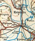
The River Severn splits at the Upper Parting between the 2-mile-long (3.2 km) West Channel,
known locally as the Maisemore Channel, [8] and the 3.6-mile-long (5.8 km) East Channel around Alney Island
[9]
X
X
West Channel crossings
Maisemore Bridge1956 51°53′19″N2°16′04″W / 51.88860°N 2.26772°W / 51.88860; -2.26772 (Maisemore Bridge) - Maisemore Carries the A417. Single masonry arch, latest of several bridges here dating back to 1230. Severn River - Maisemore Bridge.jpg
New Over Bridge (Northern Bypass)1974 51°52′30″N2°16′04″W / 51.87501°N 2.26790°W / 51.87501; -2.26790 (Gloucester Bypass Bridge) -Gloucester A40 The new bridge at Over - geograph.org.uk - 435116.jpg
Over Bridge 1829 51°52′28″N2°16′05″W / 51.87448°N 2.26797°W / 51.87448; -2.26797 (Over Bridge)
SM
GloucesterSingle masonry arch, built by Thomas Telford. Telford's Over Bridge-geograph-5905346-by-Martin-Richard-Phelan.jpg
Over Railway Bridge1957 51°52′26″N2°16′05″W / 51.87378°N 2.26818°W / 51.87378; -2.26818 (Over Railway Bridge) -GloucesterRailway bridge on the Gloucester to Newport Line. Originally the lowest railway crossing downstream as part of the South Wales Railway, until the construction of the Severn Tunnel. The railway bridge at Over - geograph-4425245-by-John-Winder.jpg
East Channel crossings
Walham Viaduct (Northern Bypass)1983 51°52′32″N2°15′37″W / 51.8755°N 2.2604°W / 51.8755; -2.2604 (Walham Viaduct) - Gloucester A40 A40 bridge (Eastern Channel) geograph-4450039-by-David-Smith.jpg
St Catherine's Viaduct 51°52′22″N2°15′26″W / 51.8728°N 2.2572°W / 51.8728; -2.2572 (St Catherine's Viaduct) - Gloucester Railway bridge on the Gloucester to Newport Line. St Catherine's Viaduct - geograph-4330182-by-Martin-Addison.jpg
Westgate Bridge (eastbound)2000 51°52′12″N2°15′24″W / 51.86997°N 2.25661°W / 51.86997; -2.25661 (Westgate Bridge (eastbound)) -Gloucester A417. It replaced an earlier bridge opened in 1974. Westgate Bridge (westgate) over the River Severn - geograph org uk - 435072.jpg
Westgate Footbridge1974 51°52′11″N2°15′24″W / 51.86977°N 2.25669°W / 51.86977; -2.25669 (Westgate Footbridge) -Gloucester Westgate Footbridge over the River Severn - geograph org uk - 435072.jpg
Westgate Bridge (westbound)2000 51°52′10″N2°15′25″W / 51.86957°N 2.25682°W / 51.86957; -2.25682 (Westgate Bridge (westbound)) -Gloucester A417. It replaced earlier bridges opened in 1189, 1809 and 1974. Westgate Bridge westbound - geograph org uk - 502958.jpg
Castle Meads Footbridge1987 51°51′52″N2°15′12″W / 51.86454°N 2.25329°W / 51.86454; -2.25329 (Castle Meads Footbridge) -Gloucester Footbridge to car park at Gloucester - geograph org uk - 701615.jpg
Castle Meads Bridge2005 51°51′45″N2°15′27″W / 51.86262°N 2.25743°W / 51.86262; -2.25743 (Castle Meads Bridge) -Gloucester A430 Beneath Llanthony Bridge.jpg
Llanthony Railway Bridge (disused) 51°51′45″N2°15′29″W / 51.86252°N 2.25816°W / 51.86252; -2.25816 (Llanthony Railway Bridge) -Gloucester Gloucester, an old railway bridge - geograph.org.uk - 1081067.jpg
Disused footbridge 51°51′44″N2°15′33″W / 51.86234°N 2.25906°W / 51.86234; -2.25906 (Disused footbridge) -Gloucester Gloucester, an old footbridge.jpg
The East and West Channels rejoin at the Lower Parting [9]
Severn tunnel (1810) 1810 51°47′16″N2°26′46″W / 51.78770°N 2.44598°W / 51.78770; -2.44598 (Severn Tunnel (1810)) - Newnham on Severn Failed attempt to build a tunnel, abandoned after water broke in View to the Arlingham side - geograph.org.uk - 2237650.jpg
Severn Railway Bridge 1876 51°43′56″N2°28′28″W / 51.73234°N 2.47441°W / 51.73234; -2.47441 (Severn Railway Bridge) - LydneySharpness Demolished 1970 after accident. Severn Railway Bridge, from near Purton - geograph.org.uk - 2041712.jpg
Severn-Wye Cable Tunnel 1973East 51°36′30″N2°36′55″W / 51.6083446°N 2.6153657°W / 51.6083446; -2.6153657 (Severn-Wye Cable Tunnel)
West 51°36′40″N2°40′09″W / 51.61098°N 2.66921°W / 51.61098; -2.66921 (Severn-Wye Cable Tunnel)
- BeachleyAust The tunnel is 47.5 m (156 ft) deep, with a diameter of 3.05 m (10 ft) and a total length of 3,678 m (2.285 mi). [10] The tunnel carries two 400 kV circuits, each with three cables. [11] The tunnel is owned by National Grid. The image to the right shows the cables on pylons entering the Aust (eastern) end of the tunnel before going underground. Pylons - geograph.org.uk - 190588.jpg
Severn Bridge 1966 51°36′33″N2°38′18″W / 51.60903°N 2.63837°W / 51.60903; -2.63837 (The Severn Bridge) I Chepstow – AustSteel suspension bridge. Listed as "Severn Bridge and Aust Viaduct, First Severn Crossing". Severn Bridge (M48) full view - geograph.org.uk - 1742850.jpg
Aust Ferry 1827 51°35′56″N2°37′59″W / 51.59888°N 2.63301°W / 51.59888; -2.63301 (Aust Ferry) -Beachley – AustClosed circa 1860. Service recommenced 1926, finally closed 1966. Aust ferry arp.jpg
Aust Severn Powerline Crossing 1959 51°36′21″N2°38′29″W / 51.60578°N 2.64136°W / 51.60578; -2.64136 (Aust Severn Powerline Crossing) -Longest powerline span in the UK at 1 mile (1,618 metres). Aust Ferry First Severn Road Bridge under construction geograph-2211848-by-Ben-Brooksbank.jpg
New Passage Ferry 1863East 51°34′28″N2°39′38″W / 51.574571°N 2.660611°W / 51.574571; -2.660611 (New Passage Ferry)
West 51°35′24″N2°42′14″W / 51.589955°N 2.703867°W / 51.589955; -2.703867 (New Passage Ferry Black Rock)
New Passage - Black Rock Railway ferry link on the Bristol and South Wales Union Railway Portskewett Pier (G J Stodart 1887).jpg
Severn Tunnel 1886 51°34′30″N2°41′20″W / 51.575°N 2.6889°W / 51.575; -2.6889 (The Severn Tunnel) -Railway tunnel, part of the South Wales Main Line. Severntunnel1.jpg
Prince of Wales Bridge (formerly known as Second Severn Crossing)1996 51°34′24″N2°41′50″W / 51.57331°N 2.69725°W / 51.57331; -2.69725 (The Second Severn Crossing) -A cable-stayed bridge which marks the official start of the Severn Estuary. The central cable-stayed portion of the second Severn Crossing - geograph.org.uk - 1700965.jpg

See also

Bibliography

Related Research Articles

<span class="mw-page-title-main">River Severn</span> River in the United Kingdom

The River Severn, at 220 miles (354 km) long, is the longest river in Great Britain. It is also the river with the most voluminous flow of water by far in all of England and Wales, with an average flow rate of 107 m3/s (3,800 cu ft/s) at Apperley, Gloucestershire. It rises in the Cambrian Mountains in mid Wales, at an altitude of 2,001 feet (610 m), on the Plynlimon massif, which lies close to the Ceredigion/Powys border near Llanidloes. The river then flows through Shropshire, Worcestershire and Gloucestershire. The county towns of Shrewsbury, Worcester and Gloucester lie on its course.

<span class="mw-page-title-main">M4 motorway</span> Major motorway in England and Wales

The M4, originally the London-South Wales Motorway, is a motorway in the United Kingdom running from west London to southwest Wales. The English section to the Severn Bridge was constructed between 1961 and 1971; the Welsh element was largely complete by 1980, though a non-motorway section around Briton Ferry bridge remained until 1993. On the opening of the Second Severn Crossing in 1996, the M4 was rerouted over it.

<span class="mw-page-title-main">River Wye</span> River in Wales and England

The River Wye is the fourth-longest river in the UK, stretching some 250 kilometres from its source on Plynlimon in mid Wales to the Severn Estuary. For much of its length the river forms part of the border between England and Wales. The Wye Valley is designated an Area of Outstanding Natural Beauty. The Wye is important for nature conservation and recreation, but is affected by pollution.

<span class="mw-page-title-main">M48 motorway</span> Motorway in the United Kingdom

The M48 is a 13-mile (21 km) long motorway in Great Britain, which crosses the Severn near Chepstow, Monmouthshire, linking England with Wales via the Severn Bridge. This road used to be the M4, and as a result is anomalously numbered: as it lies to the north of the M4 and to the west of the M5, it is in the Motorway Zone 5. The M4, M48 and the A48(M) motorway are the only motorways in Wales.

<span class="mw-page-title-main">Aust</span> Human settlement in England

Aust is a small village in South Gloucestershire, England, about 10 miles (16 km) north of Bristol and about 28 miles (45 km) south west of Gloucester. It is located on the eastern side of the Severn estuary, close to the eastern end of the Severn Bridge which carries the M48 motorway. The village has a chapel, a church and a public house. There is a large area of farmland on the river bank, which is sometimes flooded due to the high tidal range of the Severn. Aust Cliff, above the Severn, is located about 0.5 miles (0.80 km) from the village. The civil parish of Aust includes the villages of Elberton and Littleton-upon-Severn.

<span class="mw-page-title-main">Severn Railway Bridge</span> Former bridge in United Kingdom

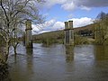
The Severn Railway Bridge was a bridge carrying the railway across the River Severn between Sharpness and Lydney in Gloucestershire, England. It was built in the 1870s by the Severn Bridge Railway Company, primarily to carry coal from the Forest of Dean to the docks at Sharpness; it was the furthest-downstream bridge over the Severn until the opening of the Severn road bridge in 1966. When the company got into financial difficulties in 1893, it was taken over jointly by the Great Western Railway and the Midland Railway companies. The bridge continued to be used for freight and passenger services until 1960, and saw temporary extra traffic on the occasions that the Severn Tunnel was closed for engineering work.

<span class="mw-page-title-main">Tidenham</span> Human settlement in England

Tidenham is a village and civil parish in the Forest of Dean of west Gloucestershire, England, adjoining the Welsh border. Tidenham is bounded by the River Wye to the west and the River Severn to the south. Offa's Dyke runs through the western part of the parish, terminating at Sedbury cliff above the River Severn.

<span class="mw-page-title-main">Severn Bridge</span> Bridge over the rivers Severn and Wye in England and Wales

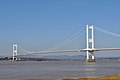
The Severn Bridge is a motorway suspension bridge that spans the River Severn between South Gloucestershire in England and Monmouthshire in South East Wales. It is the original Severn road crossing between England and Wales, and took three and a half years to build, at a cost of £8 million. It replaced the 137-year-old Aust Ferry.

<span class="mw-page-title-main">Arlingham</span> Human settlement in England

Arlingham is a village and civil parish in the Stroud District of Gloucestershire, England. The 2021 Census recorded a parish population of 533. The parish contains the hamlets of Milton End, Overton and Priding. The next parish to the east is Fretherne with Saul.

<span class="mw-page-title-main">A466 road</span> Road in England and Wales

The A466, also known as the Wye Valley Road, is a road from Hereford, England to Chepstow, Wales via Monmouth, Tintern and the Wye Valley.

<span class="mw-page-title-main">Aust Severn Powerline Crossing</span> Power line span over the River Severn in Great Britain

Aust Severn Powerline Crossing is the longest overhead power line span in the United Kingdom with a length of 1,618 m (5,308 ft).

<span class="mw-page-title-main">Elan aqueduct</span> Water connection between Powys and Birmingham

The Elan aqueduct crosses Wales and the Midlands of England, running eastwards from the Elan Valley Reservoirs in Mid Wales to Birmingham's Frankley Reservoir, carrying drinking water for Birmingham.

<span class="mw-page-title-main">Wye Valley Railway</span> Disused railway in England and Wales

The Wye Valley Railway was a standard gauge railway that ran for nearly 15 miles (24 km) along the Lower Wye Valley between the towns of Chepstow and Monmouth, crossing several times between Wales and England. Opened on 1 November 1876, it was leased to, and worked by, the Great Western Railway (GWR), before being fully absorbed by the GWR in 1905.

<span class="mw-page-title-main">Ross and Monmouth Railway</span>

The Ross and Monmouth Railway was a standard gauge railway of 13 miles (21 km) which ran between Ross-on-Wye, in Herefordshire, England and Monmouth, Wales.

<span class="mw-page-title-main">Severn Bridge Railway</span> United Kingdom legislation

The Severn Bridge Railway was a railway company which constructed a railway from Lydney to Sharpness in Gloucestershire, England. It was intended chiefly to give access for minerals in the Forest of Dean to Sharpness Docks, and the company built a long bridge, 1,387 yards (1,268 m) in length, over the River Severn. The line opened in 1879.

<span class="mw-page-title-main">Bridges and tunnels across the Yangtze River</span>

The bridges and tunnels across the Yangtze River carry rail and road traffic across China's longest and largest river and form a vital part of the country's transportation infrastructure. The river bisects China proper from west to east, and every major north–south bound highway and railway must cross the Yangtze. Large urban centers along the river such as Chongqing, Wuhan, and Nanjing also have urban mass transit rail lines crossing the Yangtze.

The Monmouth Railway, also known as the Monmouth Tramroad, was a horse-drawn 3 ft 6 in gauge plateway. It ran for about 5 miles (8.0 km) from Howler's Slade, east of Coleford, in Gloucestershire and Monmouth; there were two branches from other mineral sites. It was intended to bring mineral products of the Forest of Dean to Monmouth, and to the works alongside the River Wye.

<span class="mw-page-title-main">Portskewett Pier railway station</span> Former railway station in Wales

Portskewett Pier was a station on the Bristol & South Wales Union Railway. The pier at Black Rock, near Portskewett, was the Welsh side of the New Passage Ferry across the River Severn. The ferry linked rail services between Bristol and South Wales, avoiding the previous long detour through Gloucester. The ferry service lasted for nearly twenty five years, from 1863 to 1886, until the opening of the railway tunnel beneath the river.

References

  1. Listed Buildings, English Heritage, archived from the original on 9 December 2012, retrieved 22 April 2011
  2. "Hampton Loade Station". Severn Valley Railway. Archived from the original on 6 July 2017. Retrieved 6 July 2017.
  3. "It's all systems go for July official opening as new cycle and footbridge gradually takes shape (From Worcester News)". Worcester News . Newsquest. Retrieved 28 June 2010.
  4. "New bridge over River Severn in Worcester opens". BBC Online . BBC. 20 July 2010. Retrieved 21 July 2010.
  5. "Ron's plaque (From Worcester News)". archive.worcesternews.co.uk. Archived from the original on 11 July 2012. Retrieved 22 May 2022.
  6. "Rhydd Ferry". H W Gwilliam. whepages. 1982. Archived from the original on 2 September 2011. Retrieved 28 May 2011.
  7. Worcestershire Sheet XL.SE (Map). 1:10,560. Ordnance Survey. 1905.
  8. "Over Bridge history and research". English Heritage . Retrieved 18 May 2011.
  9. 1 2 "River Severn at Gloucester: Flood Risk Management Study" (PDF). Environment Agency. Archived from the original (PDF) on 14 March 2011. Retrieved 18 May 2011.
  10. "Mono Severn Wye Tunnel Project wins award". Archived from the original on 11 October 2012. Retrieved 10 May 2011.
  11. "Severn-Wye Cable Tunnel refurb". Global Trade Media. Archived from the original on 28 July 2011. Retrieved 10 May 2011.