Foothills County

Last updated

Foothills County
Municipal District of Sheep River No. 31 (1954)
Municipal District of Foothills No. 31 (19542018)
Foothills No 31, Alberta.svg
AB locator FOOTHILLS COUNTY.svg
Location
CountryCanada
Province Alberta
Region Calgary Region
Census division 6
Established1944
Incorporated1944
Name changeJanuary 1, 2019
Government
   Reeve Delilah Miller
  Governing bodyFoothills County Council
  CAORyan Payne
   Administrative office High River
Area
 (2021) [1]
  Land3,604.76 km2 (1,391.81 sq mi)
Population
 (2021) [1]
  Total23,199
  Density6.4/km2 (17/sq mi)
Time zone UTC−7 (MST)
  Summer (DST) UTC−6 (MDT)
Website mdfoothills.com

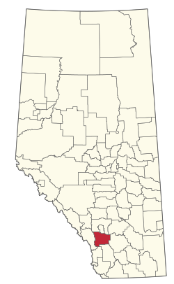
Foothills County is a municipal district in southern Alberta, Canada adjacent to the south side of Calgary in Census Division No. 6. Despite sharing a common border with the City of Calgary, it does not form part of the Calgary census metropolitan area (CMA) as defined by Statistics Canada. It is however a member municipality of the Calgary Metropolitan Region Board.

Contents

History

Foothills County was originally formed as the Municipal District (MD) of Sheep River No. 31 on January 1, 1954, through the amalgamation of portions of Improvement District No. 46 and the MDs of Highwood No. 31, Turner Valley No. 32, and Springbank No. 45. [2] Its name was changed to the MD of Foothills No. 31 shortly thereafter on March 25, 1954. [2] Foothills County assumed its present name on January 1, 2019. [3]

Geography

Communities and localities

The following localities are located within Foothills County. [5]

Localities

Demographics

In the 2021 Census of Population conducted by Statistics Canada, Foothills County had a population of 23,199 living in 8,450 of its 9,075 total private dwellings, a change of

In the 2016 Census of Population conducted by Statistics Canada, Foothills County had a population of 22,766 living in 8,156 of its 8,689 total private dwellings, a

Attractions

See also

Related Research Articles

<span class="mw-page-title-main">Sturgeon County</span> Municipal district in Alberta, Canada

Sturgeon County is a municipal district in the Edmonton Metropolitan Region of Alberta, Canada. It is north of Edmonton and west of the North Saskatchewan River. Sturgeon County is located in Division No. 11 and was named for the Sturgeon River.

<span class="mw-page-title-main">Rocky View County</span> Municipal district in Alberta, Canada

Rocky View County is a municipal district in southern Alberta, Canada that is named for its views of the nearby Rocky Mountains to the west. It surrounds most of Calgary, forming the city's northern boundary and most of the city's western and eastern boundaries. At a population of 41,028 in 2021, Rocky View County is the most populous municipal district in Alberta. Though predominantly rural in nature, Rocky View County is home to 14 hamlets, including Langdon, one of Alberta's most populous hamlets. Its rural areas are home to numerous country residential subdivisions.

<span class="mw-page-title-main">Irricana</span> Town in Alberta, Canada

Irricana is a town in the Calgary Metropolitan Region of Alberta, Canada. Surrounded by Rocky View County, it is adjacent to Highway 9, approximately 53 kilometres (33 mi) northeast of Calgary.

<span class="mw-page-title-main">Red Deer County</span> Municipal district in Alberta, Canada

Red Deer County is a municipal district in central Alberta, Canada within Census Division No. 8 and surrounding the City of Red Deer. The neighbouring municipalities of Red Deer County are Clearwater County to the west, Lacombe County to the north, the County of Stettler No. 6 to the east, Kneehill County to the southeast and Mountain View County to the south. It is located approximately midway between Edmonton and Calgary, bisected by the Queen Elizabeth II Highway and bounded on the north and east by the Red Deer River.

<span class="mw-page-title-main">Municipal District of Bonnyville No. 87</span> Municipal district in Alberta, Canada

The Municipal District of Bonnyville No. 87 is a municipal district (MD) in northeastern Alberta, Canada in Division No. 12. On the east, it is adjacent to the province of Saskatchewan.

<span class="mw-page-title-main">Municipal District of Taber</span> Municipal district in Alberta, Canada

The Municipal District of Taber is a municipal district (MD) in southern Alberta, Canada. It is located in Census Division 2.

<span class="mw-page-title-main">Municipal District of Acadia No. 34</span> Municipal district in Alberta, Canada

The Municipal District of Acadia No. 34 is a municipal district (MD) in southern Alberta, Canada, east of Calgary, close to the Saskatchewan border, in Census Division No. 4.

<span class="mw-page-title-main">Municipal District of Bighorn No. 8</span> Municipal district in Alberta, Canada

The Municipal District of Bighorn No. 8 is a municipal district (MD) situated in Census Division No. 15 of Alberta, Canada. It is located between Calgary and Banff National Park, north of Kananaskis Improvement District. Highway 1 passes through the municipal district.

<span class="mw-page-title-main">Municipal District of Fairview No. 136</span> Municipal district in Alberta, Canada

The Municipal District of Fairview No. 136 is a municipal district (MD) in northwestern Alberta, Canada. It is located in Census Division 19.

<span class="mw-page-title-main">Municipal District of Lesser Slave River No. 124</span> Municipal district in Alberta, Canada

The Municipal District of Lesser Slave River No. 124 is a municipal district (MD) in north-central Alberta, Canada. Its municipal office is located in the Town of Slave Lake. Located in Census Division 17, the MD takes its name from Lesser Slave River, which drains Lesser Slave Lake into the Athabasca River.

<span class="mw-page-title-main">Municipal District of Opportunity No. 17</span> Municipal district in Alberta, Canada

The Municipal District of Opportunity No. 17 is a municipal district (MD) occupying a remote area in central northern Alberta, Canada. Located in Census Division 17 north of the Town of Athabasca, its municipal office is located in the Hamlet of Wabasca.

<span class="mw-page-title-main">County of Northern Lights</span> Municipal district in Alberta, Canada

The County of Northern Lights is a municipal district in northwest Alberta, Canada. Located in Census Division 17, its municipal office is located in the Town of Manning.

<span class="mw-page-title-main">Municipal District of Smoky River No. 130</span> Municipal district in Alberta, Canada

The Municipal District of Smoky River No. 130 is a municipal district (MD) in northwestern Alberta, Canada. Located in Census Division No. 19, its municipal office is located in the Town of Falher.

<span class="mw-page-title-main">Municipal District of Wainwright No. 61</span> Municipal district in Alberta, Canada

The Municipal District of Wainwright No. 61 is a municipal district (MD) in eastern Alberta, Canada. Located in Census Division No. 7., its municipal office is located in the Town of Wainwright. The municipal district is bisected north-south by the Buffalo Trail and east-west by the Poundmaker Trail.

<span class="mw-page-title-main">Municipal District of Willow Creek No. 26</span> Municipal district in Alberta, Canada

The Municipal District of Willow Creek No. 26 is a municipal district (MD) in southern Alberta, Canada. Located in Census Division No. 3, its municipal office is located adjacent to Claresholm Industrial Airport, west of the Town of Claresholm.

<span class="mw-page-title-main">Smoky Lake County</span> Municipal district in Alberta, Canada

Smoky Lake County is a municipal district in north-eastern Alberta, Canada. Located in Census Division No. 12, its municipal office is located in the Town of Smoky Lake.

<span class="mw-page-title-main">Municipal District of Spirit River No. 133</span> Municipal district in Alberta, Canada

The Municipal District of Spirit River No. 133 is a municipal district (MD) in northwest Alberta, Canada, north of Grande Prairie. Located in the Upper Peace Region, its municipal office is located in the Town of Spirit River. With an area of 683.6 km2 (263.9 sq mi), it is the smallest municipal district in Alberta.

<span class="mw-page-title-main">Municipal District of Ranchland No. 66</span> Municipal district in Alberta, Canada

The Municipal District of Ranchland No. 66 is a municipal district (MD) in southwest Alberta, Canada. Containing no urban communities of any kind, its municipal office is located in Chain Lakes Provincial Park, approximately 38 km (24 mi) southwest of the Town of Nanton. Ranchland's rugged foothill terrain is unsuited for the crop agriculture practiced elsewhere in Alberta, and ranching remains the single livelihood of its inhabitants. With a 2016 population of 92, it is the least populated municipal district in Alberta, and its population density of 29 square kilometres for every resident is almost exactly equal to that of the Northwest Territories.

<span class="mw-page-title-main">Municipal District of Provost No. 52</span> Municipal district in Alberta, Canada

The Municipal District of Provost No. 52 is a municipal district (MD) in east-central Alberta, Canada, on the Alberta/Saskatchewan border. Located in Census Division No. 7, its municipal office is located in the Town of Provost.

<span class="mw-page-title-main">Municipal District of Pincher Creek No. 9</span> Municipal district in Alberta, Canada

The Municipal District of Pincher Creek No. 9 is a municipal district (MD) in southwestern Alberta, Canada. Located in Census Division No. 3, its municipal office is located in the Town of Pincher Creek.

References

  1. 1 2 3 "Population and dwelling counts: Canada, provinces and territories, and census subdivisions (municipalities)". Statistics Canada. February 9, 2022. Retrieved February 9, 2022.
  2. 1 2 "Location and History Profile: Foothills County" (PDF). Alberta Municipal Affairs. May 15, 2020. pp. 127–128. Retrieved May 16, 2020.
  3. "O.C. 396/2018". Government of Alberta. December 11, 2018. Retrieved May 16, 2020.
  4. 1 2 "Specialized and Rural Municipalities and Their Communities" (PDF). Alberta Municipal Affairs. January 12, 2022. Retrieved January 21, 2022.
  5. "Standard Geographical Classification (SGC) 2006, Economic Regions: 4806001 - Foothills No. 31, geographical codes and localities, 2006". Statistics Canada. March 5, 2010. Archived from the original on May 25, 2013. Retrieved August 11, 2012.
  6. "Population and dwelling counts, for Canada, provinces and territories, and census subdivisions (municipalities), 2016 and 2011 censuses – 100% data (Alberta)". Statistics Canada. February 8, 2017. Retrieved February 8, 2017.