Municipal District of Peace No. 135

Last updated

Municipal District of Peace No. 135
Peace Country grain fields.JPG
Grain fields in the Peace Country
AB MD of Peace logo.png
AB locator MUNICIPAL DISTRICT OF PEACE NO 135.svg
Location within Alberta
CountryCanada
Province Alberta
Region Northern Alberta
Census division 19
Established1916
Incorporated1945
Government
[1]
   Reeve Robert Willing
  Governing bodyMD of Peace Council
   Administrative office adjacent to Berwyn
Area
 (2021) [2]
  Land847.22 km2 (327.11 sq mi)
Population
 (2021) [2]
  Total1,581
  Density1.9/km2 (5/sq mi)
Time zone UTC−7 (MST)
  Summer (DST) UTC−6 (MDT)
Website mdpeace.com

The Municipal District of Peace No. 135 is a municipal district (MD) in northwestern Alberta, Canada. Located in Census Division No. 19, its municipal office is located outside but adjacent to the Village of Berwyn.

Contents

Geography

Communities and localities

Demographics

In the 2021 Census of Population conducted by Statistics Canada, the MD of Peace No. 135 had a population of 1,581 living in 577 of its 654 total private dwellings, a change of

In the 2016 Census of Population conducted by Statistics Canada, the MD of Peace No. 135 had a population of 1,747 living in 578 of its 639 total private dwellings, a

Economy

Agriculture is a significant part of the area's economy, with the region being dubbed as most northern agricultural industry oasis in the world. [17] The region has unique growing combination of a northern climate, fertile soils, and a watershed system fed by glacial run offs.

Attractions

See also

Related Research Articles

<span class="mw-page-title-main">Fairview, Alberta</span> Town in Alberta, Canada

Fairview is a town in Peace Country, Alberta, Canada. It is located 82 km (51 mi) southwest of Peace River and 115 km (71 mi) north of Grande Prairie at the intersection of Highway 2 and Highway 64A.

<span class="mw-page-title-main">Sexsmith, Alberta</span> Town in Alberta, Canada

Sexsmith is a town in northern Alberta, it is on Highway 2, 20 kilometres (12 mi) north of Grande Prairie.

<span class="mw-page-title-main">Strathmore, Alberta</span> Town in Alberta, Canada

Strathmore is a town located in southern Alberta, Canada that is surrounded by Wheatland County. It is along the Trans-Canada Highway approximately 50 kilometres (30 mi) east of Calgary.

<span class="mw-page-title-main">County of Grande Prairie No. 1</span> Municipal district in Alberta, Canada

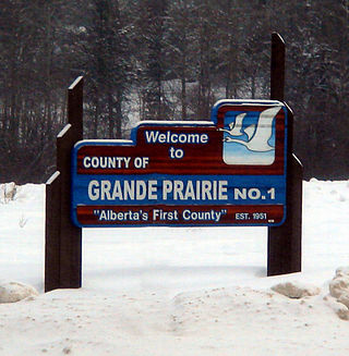
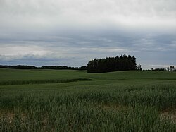
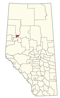
The County of Grande Prairie No. 1 is a municipal district in northwestern Alberta, Canada in Census Division No. 19.

<span class="mw-page-title-main">High Prairie</span> Town in Alberta, Canada

High Prairie is a town in northern Alberta, Canada within Big Lakes County. It is located at the junction of Highway 2 and Highway 749, approximately 89 km (55 mi) northeast of Valleyview and 118 km (73 mi) west of Slave Lake.

<span class="mw-page-title-main">McLennan, Alberta</span> Town in Alberta, Canada

McLennan is a town in northern Alberta, Canada. It is approximately 50 km (31 mi) north of High Prairie on Highway 2.

<span class="mw-page-title-main">Spirit River, Alberta</span> Town in Alberta, Canada

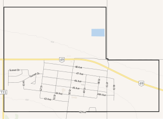
Spirit River is a town in northern Alberta, Canada. It is approximately 78 km (48 mi) north of Grande Prairie at the junction of Highway 49 and Highway 731.

<span class="mw-page-title-main">Wembley, Alberta</span> Town in Alberta, Canada

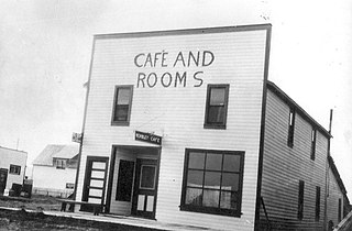
Wembley is a town in northern Alberta, Canada. It is approximately 23 km (14 mi) west of Grande Prairie at the junction of Highway 43 and Highway 724.

Berwyn is a village in northwestern Alberta, Canada. It is located approximately 37 km (23 mi) west of the Town of Peace River, 10 km (6.2 mi) southwest of the Town of Grimshaw, and 15 km (9.3 mi) northeast of the Duncan's First Nation reserve.

<span class="mw-page-title-main">Donnelly, Alberta</span> Village in Alberta, Canada

Donnelly is a village in northern Alberta, Canada within the Municipal District of Smoky River No. 130. It is located near the intersection of Highway 2 and Highway 49, located approximately 65 km (40 mi) south of Peace River and 427 km (265 mi) northwest of Edmonton.

<span class="mw-page-title-main">Girouxville</span> Village in Alberta, Canada

Girouxville is a village in northern Alberta, Canada. It is located 58 kilometres (36 mi) south of the Town of Peace River.

<span class="mw-page-title-main">Hines Creek</span> Village in Alberta, Canada

Hines Creek is a village in northern Alberta, Canada. It is located 67 km west of Grimshaw and 28 km north of Fairview, along Highway 64.

<span class="mw-page-title-main">Hythe, Alberta</span> Hamlet in Alberta, Canada

Hythe is a hamlet in northwest Alberta, Canada within the County of Grande Prairie No. 1. It is located on Highway 43 approximately 58 km (36 mi) northwest of the City of Grande Prairie and 73 km (45 mi) southeast of the City of Dawson Creek, British Columbia. It held village status prior to July 2021.

<span class="mw-page-title-main">Kinuso</span> Hamlet in Alberta, Canada

Kinuso is a hamlet in northern Alberta, Canada within Big Lakes County, and surrounded by the Swan River First Nation reserve. It is located approximately 48 kilometres (30 mi) west of Slave Lake and 71 km east of High Prairie along Highway 2, south of the southern shore of Lesser Slave Lake.

<span class="mw-page-title-main">Rycroft, Alberta</span> Village in Alberta, Canada

Rycroft is a village in northern Alberta, Canada. It is approximately 68 km (42 mi) north of Grande Prairie and 7 km (4.3 mi) east of Spirit River. Dunvegan Provincial Park is located 20 km north of the community.

<span class="mw-page-title-main">Municipal District of Acadia No. 34</span> Municipal district in Alberta, Canada

The Municipal District of Acadia No. 34 is a municipal district (MD) in southern Alberta, Canada, east of Calgary, close to the Saskatchewan border, in Census Division No. 4.

<span class="mw-page-title-main">Municipal District of Fairview No. 136</span> Municipal district in Alberta, Canada

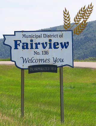
The Municipal District of Fairview No. 136 is a municipal district (MD) in northwestern Alberta, Canada. It is located in Census Division 19.

<span class="mw-page-title-main">Municipal District of Smoky River No. 130</span> Municipal district in Alberta, Canada

The Municipal District of Smoky River No. 130 is a municipal district (MD) in northwestern Alberta, Canada. Located in Census Division No. 19, its municipal office is located in the Town of Falher.

<span class="mw-page-title-main">Municipal District of Spirit River No. 133</span> Municipal district in Alberta, Canada

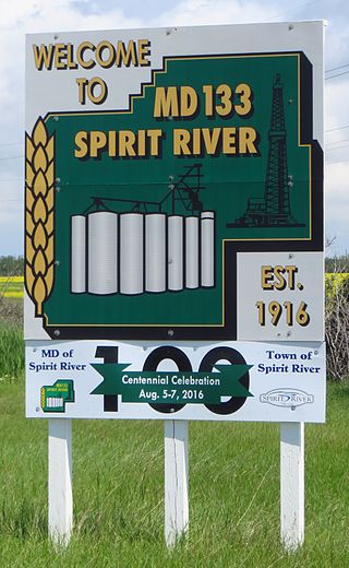
The Municipal District of Spirit River No. 133 is a municipal district (MD) in northwest Alberta, Canada, north of Grande Prairie. Located in the Upper Peace Region, its municipal office is located in the Town of Spirit River. With an area of 683.6 km2 (263.9 sq mi), it is the smallest municipal district in Alberta.

Wanham is a hamlet in northern Alberta, Canada within Birch Hills County. It is located 29 km (18 mi) east of Rycroft along Highway 49 and approximately 106 km (66 mi) north of Grande Prairie, in the farmlands of Peace River Country. Saddle River, a tributary of Peace River, flows immediately north of the community. The origin of the name Wanham could have come from Wanham in England.

References

  1. "Municipal Officials Search". Alberta Municipal Affairs. May 9, 2019. Retrieved October 1, 2021.
  2. 1 2 3 "Population and dwelling counts: Canada, provinces and territories, and census subdivisions (municipalities)". Statistics Canada. February 9, 2022. Retrieved February 9, 2022.
  3. 1 2 "Specialized and Rural Municipalities and Their Communities" (PDF). Alberta Municipal Affairs. January 12, 2022. Retrieved January 21, 2022.
  4. "Standard Geographical Classification (SGC) 2006, Economic Regions: 4819071 - Peace No. 135, geographical codes and localities, 2006". Statistics Canada. March 5, 2010. Retrieved August 12, 2012.
  5. "Table IV: Population of Prairie Provinces by Municipalities, Local Improvement Districts or Unorganized Territorial Units, 1916". Census of Prairie Provinces, 1916. Ottawa: Department of Trade and Commerce. 1918.
  6. "Table 6: Population by census divisions of Alberta classified by municipalities for census years, 1921 and 1926". Census of Prairie Provinces, 1926. Ottawa: Department of Trade and Commerce. 1929.
  7. "Table 6: Population by census subdivisions, 1926-1946". Census of the Prairie Provinces, 1946. Vol. I: Population. Ottawa: Dominion Bureau of Statistics. 1949.
  8. "Table 6: Population by sex, for census subdivisions, 1956 and 1951". Census of Canada, 1956. Vol. I: Population. Ottawa: Dominion Bureau of Statistics. 1958.
  9. "Table 9: Population by census subdivisions, 1966 by sex, and 1961". 1966 Census of Canada. Western Provinces. Vol. Population: Divisions and Subdivisions. Ottawa: Dominion Bureau of Statistics. 1967.
  10. "Table 3: Population for census divisions and subdivisions, 1971 and 1976". 1976 Census of Canada. Census Divisions and Subdivisions, Western Provinces and the Territories. Vol. Population: Geographic Distributions. Ottawa: Statistics Canada. 1977.
  11. "Table 2: Census Subdivisions in Alphabetical Order, Showing Population Rank, Canada, 1981". 1981 Census of Canada. Vol. Census subdivisions in decreasing population order. Ottawa: Statistics Canada. 1982. ISBN   0-660-51563-6.
  12. "Table 2: Population and Dwelling Counts, for Census Divisions and Census Subdivisions, 1986 and 1991 – 100% Data". 91 Census. Vol. Population and Dwelling Counts – Census Divisions and Census Subdivisions. Ottawa: Statistics Canada. 1992. pp. 100–108. ISBN   0-660-57115-3.
  13. "Population and Dwelling Counts, for Canada, Provinces and Territories, and Census Divisions, 2001 and 1996 Censuses – 100% Data (Alberta)". Statistics Canada . Retrieved May 28, 2019.
  14. "Population and dwelling counts, for Canada, provinces and territories, and census subdivisions (municipalities), 2006 and 2001 censuses – 100% data (Alberta)". Statistics Canada. January 6, 2010. Retrieved May 28, 2019.
  15. "Census Profile, 2016 Census". Statistics Canada. February 8, 2017. Retrieved May 28, 2019.
  16. "Population and dwelling counts, for Canada, provinces and territories, and census subdivisions (municipalities), 2016 and 2011 censuses – 100% data (Alberta)". Statistics Canada. February 8, 2017. Retrieved February 8, 2017.
  17. "Defining Quality of Peace Country Agriculture" (PDF). Branding the Peace Country Association. April 2009. Archived from the original (PDF) on October 3, 2011. Retrieved March 23, 2011.