
Lexden is a suburb of Colchester and former civil parish, in the county of Essex, England. It was formerly a village, and has previously been called Lessendon, Lassendene and Læxadyne. In 2011 the ward had a population of 5,549.

The City of Colchester is a local government district with city status in Essex, England, named after its main settlement, Colchester. The district also includes the towns of West Mersea and Wivenhoe and the surrounding rural areas stretching from Dedham Vale on the Suffolk border in the north to Mersea Island in the Colne Estuary in the south.

Sturminster Marshall is a village and civil parish in the east of Dorset in England, situated on the River Stour between Blandford Forum and Poole. The parish had a population of 1,895 at the 2001 census, increasing to 1,969 at the 2011 Census and includes the village of Almer west of Sturminster Marshall, near Winterborne Zelston and the hamlet of Henbury to the south-east of the village. The village is twinned with the French commune of Sainte-Mère-Église in Normandy. The appropriate electoral ward is called 'Stour'. From Sturminster Marshall the ward goes east to Pamphill, with a total population of 2,582.

Tiptree is a village and civil parish in the English county of Essex, situated 10 miles (16 km) south-west of Colchester and around 50 miles (80 km) north-east of London. Surrounding villages include Messing, Tolleshunt Knights, Tolleshunt Major, Layer Marney, Inworth, Birch, Great Braxted, Great Totham and Little Totham.

Fingringhoe is a village and civil parish in the City of Colchester district of Essex, England. The centre of the village is classified as a conservation area, featuring a traditional village pond and red telephone box. The Roman River flows nearby before entering the River Colne. It has been noted frequently on lists of unusual place names. The village's name actually derives from its geographic circumstances: it sits at the confluence of the smaller Roman River and the River Colne. A "hoe" refers to a jutting out piece of land while "finger" describes an elongated finger-like land extension. "Ing" is a common toponym in the UK referring to "peoples". As such, the name refers to the "people living on the land jutting out into the river".

Saffron Walden is a constituency in Essex, represented in the House of Commons of the UK Parliament since 2017 by Kemi Badenoch, a Conservative.

Stanway is a village and civil parish in Essex, England near Colchester and within Colchester Borough. 'Stanway' is an Anglo-Saxon name for the 'stone way' of the Roman road, now the A12.

The Rodings are a group of eight villages in the upper part of the River Roding and the west of Essex, England, the largest group in the country to bear a common name. The Rodings do not lie within a single district in the county; they are arranged around the tripoint of the administrative areas of Chelmsford, Uttlesford and Epping Forest. An alternative arcane name, linked to the Middle English Essex dialect, was The Roothings.

Aldham is a village and civil parish in the City of Colchester district of Essex, England. It is located 4+1⁄2 mi (7.2 km) west of Colchester. The village is in the parliamentary constituency of Harwich and North Essex. The village has its own parish council.

Alresford is a village and electoral ward in Essex, England. It is centred 9 km (5.6 mi) southeast of Colchester and is 39 km (24 mi) northeast from the county town of Chelmsford. The village and its civil parish are the district of Tendring. The local primary school is Alresford Primary School and the village has a pre-school and church. Alresford won the Essex Village of the year competition in 2012 and tied for first place for another Essex Village of the Year award in 2019.
Bures St Mary is a civil parish in the Babergh district of the English county of Suffolk. In 2005 it had a population of 940, reducing to 918 at the 2011 Census. The parish covers the eastern part of the village of Bures, the western part being in the Bures Hamlet parish in Essex divided by the River Stour.
Bures is a village in eastern England that straddles the Essex/Suffolk border, made up of two civil parishes: Bures Hamlet in Essex and Bures St. Mary in Suffolk.

Dedham is a village in the City of Colchester district of Essex, England. It is near the River Stour, which is the border of Essex and Suffolk. The nearest town to Dedham is the small market town of Manningtree.

Earls Colne is a village in Essex, England named after the River Colne, on which it stands, and the Earls of Oxford who held the manor of Earls Colne from before 1086 to 1703.

Chappel is a village and civil parish in the City of Colchester district of Essex, England. The River Colne flows through the village. It is significant for its Victorian viaduct, which crosses the Colne valley.

Wormingford is a village and civil parish in the City of Colchester district of Essex, England.

Little Cornard is a village and civil parish in Suffolk, England. Located around 0.5 miles (0.8 km) from its larger sibling, Great Cornard, on the B1508 road between Sudbury and Colchester, it is part of Babergh district, and has a population of 305, reducing to 286 at the 2011 Census. The parish also includes the hamlet of Workhouse Green.
Leavenheath is a village and civil parish in Suffolk, England, close to the Essex border. Located on the A134 between Sudbury and Colchester, it is part of Babergh district. The parish also contains the hamlets of Cock Street and Honey Tye, and in 2001 had a population of 1,373, falling slightly to 1,370 at the 2011 Census.
Hemp's Green or Hemps Green is a hamlet in the civil parish of Fordham, in the Colchester borough and the county of Essex, England.

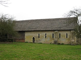
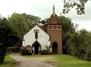
All Saints Church is a Church of England parish church in Fordham, Essex. The church is a Grade I listed building.

