Cumberland County is a county in the Canadian province of Nova Scotia.

Delta is a city in the Lower Mainland region of British Columbia, Canada, as part of Greater Vancouver. Located on the Fraser Lowland south of Fraser River's south arm, it is bordered by the city of Richmond on the Lulu Island to the north, New Westminster to the northeast, Surrey to the east, the Boundary Bay and the American pene-exclave Point Roberts to the south, and the Strait of Georgia to the west.

Cache Creek is a historic transportation junction and incorporated village 354 kilometres (220 mi) northeast of Vancouver in British Columbia, Canada. It is on the Trans-Canada Highway in the province of British Columbia at a junction with Highway 97. The same intersection and the town that grew around it was at the point on the Cariboo Wagon Road where a branch road, and previously only a trail, led east to Savona's Ferry on Kamloops Lake. This community is also the point at which a small stream, once known as Riviere de la Cache, joins the Bonaparte River.

Jasper is a specialized municipality and townsite in western Alberta within the Canadian Rockies. The townsite is in the Athabasca River valley and is the commercial centre of Jasper National Park.
McBride is a village in the Robson Valley region of British Columbia, Canada. The village is located 210 km (130 mi) southeast of Prince George, British Columbia, and 166 km (103 mi) west of Jasper, Alberta. Incorporated in 1932, McBride is located in the Robson Valley surrounded by the Rocky Mountains and Cariboo Ranges.

Burns Lake is a rural village in the North-western-Central Interior of British Columbia, Canada, incorporated in 1923. The village had a population of 1,779 as of the 2016 Census.

The Regional District of Bulkley–Nechako (RDBN) is a regional district in the Canadian province of British Columbia, Canada. As of the 2016 census, the population was 37,896. The area is 73,419.01 square kilometres. The regional district offices are in Burns Lake.
Telkwa is a village located along British Columbia Highway 16, nearly 15 kilometres (9 mi) southeast of the town of Smithers and 350 kilometres (220 mi) west of the city of Prince George, in northwest British Columbia, Canada.
Vanderhoof is a district municipality near the geographical centre of British Columbia, Canada. Covering 2.92 square kilometers., it has a population of about 4,500 within town limits, and offers services to nearly 10,000 people in nearby rural communities. Its main industries are forestry, agriculture, and related businesses. Tourism is also growing, and mining operations are being developed in the area. It has many elementary schools, and one major secondary school, Nechako Valley Secondary School (NVSS), comprising School District 91 Nechako Lakes. The College of New Caledonia has a regional campus there.

The Peace River Regional District is a regional district in northeastern British Columbia, Canada. The regional district comprises seven municipalities and four electoral areas. Its member municipalities are the cities of Fort St. John and Dawson Creek, the district municipalities of Tumbler Ridge, Chetwynd, Taylor, and Hudson's Hope, and the village of Pouce Coupe. The district's administrative offices are in Dawson Creek.
Denare Beach is a northern village on the east shore of Amisk Lake, Saskatchewan. Located on Highway 167, the community is 20 kilometres (12 mi) south-west of Flin Flon and 422 kilometres (262 mi) north-east of Prince Albert.

The Northern Rockies Regional Municipality (NRRM), formerly the Northern Rockies Regional District (NRRD), and before that the Fort Nelson–Liard Regional District, is a municipality in northeastern British Columbia, Canada. Although portrayed as a regional municipality in its official name, and existing on the same administrative level as a regional district, it is actually classified as a district municipality. The NRRM's offices are located in Fort Nelson, formerly an incorporated town that amalgamated with the NRRD on February 6, 2009 to form the NRRM. With the Peace River Regional District as the southern part, it was the northern part of the Peace River-Liard Regional District, which was split into two on October 31, 1987.

Fort Vermilion is a hamlet on the Peace River in northern Alberta, Canada, within Mackenzie County.

Fort Fraser is an unincorporated village of about 500 people, situated near the base of Fraser Mountain, close to the village municipality of Fraser Lake and the Nechako River. It can be found near the geographical centre of British Columbia, Canada, 44 km (27 mi) west of Vanderhoof on the Yellowhead Highway. Originally established in 1806 as a North West Company fur trading post by the explorer Simon Fraser, it is one of present-day British Columbia's oldest permanent European-founded settlements. The area around the community is also recorded as the site of the first land in British Columbia cultivated by non-First Nations people.

Houston is a forestry, mining and tourism town in the Bulkley Valley of the Northern Interior of British Columbia, Canada. Its urban population is approximately 3600 people, with approximately 2000 in the surrounding rural area. It is known as the "steelhead capital" and it has the world's largest fly fishing rod. Houston's tourism industry is largely based on ecotourism and Steelhead Park, situated along Highway 16. Houston is named in honour of the pioneer newspaperman John Houston.
The Regional District of Fraser–Fort George (RDFFG) is a regional district located in the Central Interior of British Columbia. It is bounded by the Alberta border to the east, the Columbia–Shuswap and Thompson–Nicola regional districts to the south and southeast, Cariboo Regional District to the southwest, the Regional District of Bulkley–Nechako to the west, and the Peace River Regional District to the north and northeast. As of the Canada 2011 Census, Fraser–Fort George had a population of 91,879 and a land area of 51,083.73 km2. The offices of the regional district are located at Prince George.
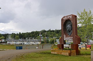
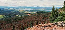
Granisle is a village on Babine Lake in the Northern Interior of British Columbia, Canada, to the north of Topley between Burns Lake and Houston.
New Hazelton is a district municipality on Highway 16 in northwest British Columbia, Canada. It is situated 133 km (83 mi) northeast of Terrace and 68 km (42 mi) northwest of Smithers and in 2016 had a population of 580 people, a decrease of 12.9% comparing to 2011. New Hazelton is one of the "Three Hazeltons", the other two being the original "Old" Hazelton located 6 km (4 mi) to the northwest very near to the confluence of the Skeena and Bulkley Rivers and South Hazelton, 5 km (3 mi) to the west.
The Nechako Region is the second-largest economic development region in British Columbia and covers an area of 200,023 km2, from the Nechako plateau, in central British Columbia, northward to the border with Yukon Territory.
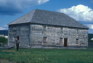
Fort St. James is a district municipality and former fur trading post in northern central British Columbia, Canada. It is located on the south-eastern shore of Stuart Lake in the Omineca Country, at the northern terminus of Highway 27, which connects to Highway 16 at Vanderhoof.