
Rickreall is an unincorporated community in Polk County, Oregon, United States. For statistical purposes, the United States Census Bureau has defined Rickreall as a census-designated place (CDP). The census definition of the area may not precisely correspond to local understanding of the area with the same name. The population of the CDP was 57 at the 2000 census. Rickreall is part of the Salem Metropolitan Statistical Area. Rickreall Creek runs along the community's southern edge.
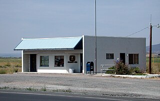
Riley is an unincorporated community in Harney County, Oregon, United States, located at the crossroads of U.S. Highway 395 and U.S. Highway 20, milepost 104, about 28 miles (45 km) west of Burns, the seat of Harney County. The elevation of Riley is 4,226 feet (1,288 m). The town presently consists entirely of two service establishments with attached apartments: a post office, and a general store with gas pump and garage service. It exists to serve the rural farming and ranching community that surrounds it, and highway travelers.
Orenco is a former company town in Washington County, Oregon, United States, located between Hillsboro and Aloha. The former community of Orenco now forms the Orenco neighborhood in Hillsboro, which is the site of the Orenco Station housing development.
Sylvan-Highlands is a neighborhood of Portland, Oregon, United States located on the west side of the West Hills.

Elmira is an unincorporated community in Lane County, Oregon, United States. It is located west of Eugene and north of Veneta and Oregon Route 126, near the Long Tom River and Fern Ridge Reservoir.

Crane is a census-designated place and unincorporated community in Harney County, Oregon, United States, northeast of Malheur Lake on Oregon Route 78. Its population was 129 at the 2010 census.

Forest Grove School District is a public school district in Washington County, Oregon, United States. It serves the communities of Cornelius, Dilley, Forest Grove and Gales Creek. David Parker is the superintendent of the district. The Forest Grove Elementary college District 15 was created in 1855 and later merged with several other districts including the Cornelius Elementary School District 2, with the larger district then later merged with the Forest Grove high school district (5). The Cornelius district was dissolved in 1960, with the western parts of the enrollment area going to the Forest Grove district and the eastern part going to the Hillsboro districts.

Gales Creek, is a tributary, 23.5 miles (37.8 km) long, of the Tualatin River in Washington County, Oregon, United States. The headwaters of Gales Creek are on the north side of the mountain Round Top in the Northern Oregon Coast Range. The community of Gales Creek, Oregon, is near the creek, which further downstream forms the southwest border of the city of Forest Grove.

Diamond is an unincorporated community in Harney County, Oregon, United States. Diamond is west of Oregon Route 205 and south of Malheur Lake, 52 miles (84 km) south-southeast of Burns by highway. Its post office is assigned ZIP code 97722.

Roy is an unincorporated historical community in Washington County, Oregon, United States. It is located south of the Sunset Highway and southeast of the city of Banks.

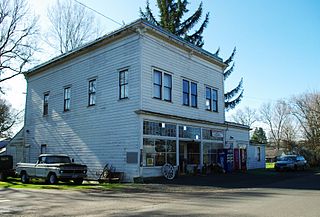
Dilley is an unincorporated community in Washington County, Oregon, United States. It is located south of Forest Grove and north of the city of Gaston on Oregon Route 47 in the Portland metropolitan area. Settled in the late 1840s, the community was platted in 1874 after the arrival of the railroad. The population of the area in 2000 was approximately 2,000.
Culp Creek is an unincorporated community in Lane County, Oregon, United States, southeast of Cottage Grove on the Row River. It lies on Row River Road between Dorena and Disston.
Glenwood is an unincorporated community in Washington County, Oregon, United States, northwest of Forest Grove on Oregon Route 6.

Farmington is an unincorporated community in Washington County, Oregon, United States. It is located on the Tualatin River, a tributary of the Willamette, about eight miles southwest of Beaverton, at the intersection of Oregon Route 10 and River Road. It is about two miles east of the junction of OR 10 with Oregon Route 219. Farmington was one of the earliest settlements in Oregon and was prominent for a time as an important milling and grain-shipping point on the Tualatin when steamships were the principal means of shipping grain along the Willamette River. Farmington was the site of an early Christian Church, founded by 1845 pioneers in Sarah and Philip Harris, who arrived in Oregon via the Meek Cutoff. At that time the locale was called "Bridgeport". Baptisms were in the Tualatin River.

Mountaindale is an unincorporated community in Washington County, Oregon, United States, about four miles northwest of North Plains. Settled in the 1850s, the small community was the longtime home of the Mountaindale Store. The area is part of Washington County Fire District 2.

Greenville is an unincorporated historic community in Washington County, Oregon, United States. It is located approximately two miles south of Banks on Oregon Route 47.
Pleasant Valley is an unincorporated community in Baker County, Oregon, United States. It is about 13 miles (21 km) southeast of Baker City on U.S. Route 30, slightly bypassed by Interstate 84.

Verboort is an unincorporated community in Washington County, Oregon, United States. It is located approximately two miles northeast of Forest Grove, one mile east of Oregon Route 47 in the Tualatin Valley. The community is part of the Forest Grove Rural Fire Protection District.

Thatcher is an unincorporated historic community in Washington County, Oregon, United States. It was located approximately three miles north of Forest Grove at the intersection of Hillside and Thatcher roads. The area is part of the Forest Grove Rural Fire Protection District.
Suntex is the name of an unincorporated community in Harney County, in the U.S. state of Oregon. It was established with the placement of a post office in the valley of Silver Creek west of Burns and north of U.S. Route 20.


