
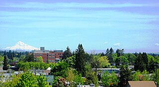
Cedar Hills is a census-designated place and neighborhood in Washington County, Oregon, United States south of U.S. Route 26 and west of Oregon Route 217 and within the Portland metropolitan area. Constructed starting in 1946.
Hillsboro is the 5th most populous city in the U.S. state of Oregon and is the county seat of Washington County. Situated in the Tualatin Valley on the west side of the Portland metropolitan area, the city hosts many high-technology companies, such as Intel, locally known as the Silicon Forest. At the 2020 census, the city's population was 106,447.

Interstate 205 (I-205) is an auxiliary Interstate Highway in the Portland metropolitan area of Oregon and Washington, United States. The north–south freeway serves as a bypass route of I-5 along the east side of Portland, Oregon, and Vancouver, Washington. It intersects several major highways and serves Portland International Airport.

Interstate 405 (I-405), also known as the Stadium Freeway No. 61, is a short north–south Interstate Highway in Portland, Oregon. It forms a loop that travels around the west side of Downtown Portland, between two junctions with I-5 on the Willamette River near the Marquam Bridge to the south and Fremont Bridge to the north.

The MAX Blue Line is a light rail service in Portland, Oregon, United States, operated by TriMet as part of the MAX Light Rail system. It travels east–west for approximately 33 miles (53 km)—the longest in the network—between Hillsboro, Beaverton, Portland, and Gresham and serves 48 stations from Hatfield Government Center to Cleveland Avenue. The line carried an average 55,370 riders each day on weekdays in September 2018, the busiest of the five MAX lines. It runs for 221⁄2 hours per day from Monday to Thursday, with headways of between 30 minutes off-peak and five minutes during rush hour. Service runs later in the evening on Fridays and Saturdays and ends earlier on Sundays.
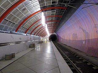
Washington Park is a light rail station in Portland, Oregon, United States, served by TriMet as part of the MAX Light Rail system. Situated between Sunset Transit Center and Goose Hollow/Southwest Jefferson Street station, it is the 17th and 3rd station eastbound on the Blue Line and the Red Line, respectively. The station's two tracks and island platform are part of the Robertson Tunnel beneath Portland's West Hills. Its head house and surface-level plaza occupy the middle of a parking lot surrounded by the Hoyt Arboretum, Oregon Vietnam Veterans Memorial, Oregon Zoo, and World Forestry Center. Washington Park is the only completely underground station in the MAX system. At 260 feet (79 m) below ground, it is the deepest transit station in North America and in the western hemisphere. It is also the seventh-deepest in the world.

The Sunset Transit Center is a TriMet bus transit center and light rail station on the MAX Blue and Red lines in Beaverton, Oregon. It opened for MAX in 1998 and is the 5th stop westbound on the Westside MAX. This is the first stop after the Robertson Tunnel under Portland's West Hills. Sunset TC is the second-busiest station on the Westside MAX line, with a weekday average of almost 6,000 daily riders in 2012. Though the station has a Portland address, it primarily serves residents of the communities of Cedar Hills, Cedar Mill, and Beaverton.

In the U.S. state of Oregon, U.S. Route 30, a major east–west U.S. Highway, runs from its western terminus in Astoria to the Idaho border east of Ontario. West of Portland, US 30 generally follows the southern shore of the Columbia River; east of Portland the highway has largely been replaced with Interstate 84, though it is signed all the way across the state, and diverges from the I-84 mainline in several towns, as a de facto business route. Out of all the states U.S. Route 30 traverses, it spends the most time in Oregon. At 477 miles, it is also the longest road in the state.

The Hillsdale district is a neighborhood in the southwest section of Portland, Oregon, United States. It is centered on the Hillsdale retail and business area, a series of strip malls on SW Capitol Highway between SW Sunset Boulevard and SW Bertha Boulevard. It is home to the Hillsdale Farmer's Market, which takes place on Sundays during the summer and every other Sunday during the winter. Hillsdale is also home to Oregon's first brewpub, with the opening of McMenamins Hillsdale Brewery in 1985.

Tanasbourne, Oregon, is a neighborhood in Washington County, Oregon, where NW 185th Avenue and the Sunset Highway intersect. It is located within the greater Portland metropolitan area. The area includes portions of Beaverton and Hillsboro, and is generally considered to be south of U.S. 26, north of Walker Road, west of 158th, and east of Cornelius Pass Road. Adjacent to Aloha and part of the West Metro region, Tanasbourne has many shopping areas and is the former home of the defunct Tanasbourne Mall.

The Sovereign Hotel was a Portland, Oregon, hotel built in 1923. The nine-story building was added to the United States' National Register of Historic Places on December 2, 1981. Part of the building houses a portion of the Oregon Historical Society's Oregon History Center.
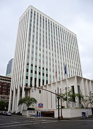
The Union Bank Tower, formerly known as the Union Bank of California Tower and originally as the Bank of California building, is an 82 m (269 ft), 15-story office building completed in 1969 in downtown Portland, Oregon. It was briefly the tallest building in the city when it topped-out in 1968, but was soon eclipsed by the Georgia-Pacific Building.

Interstate 5 (I-5) in the U.S. state of Oregon is a major Interstate Highway that traverses the state from north to south. It travels to the west of the Cascade Mountains, connecting Portland to Salem, Eugene, Medford, and other major cities in the Willamette Valley and across the northern Siskiyou Mountains. The highway runs 308 miles (496 km) from the California state line near Ashland to the Washington state line in northern Portland, forming the central part of Interstate 5's route between Mexico and Canada.

Interstate 84 (I-84) in the U.S. state of Oregon is a major Interstate Highway that traverses the state from west to east. It is concurrent with U.S. Route 30 (US 30) for most of its length and runs 376 miles (605 km) from an interchange with I-5 in Portland to the Idaho state line near Ontario. The highway roughly follows the Columbia River and historic Oregon Trail in northeastern Oregon, and is designated as part of Columbia River Highway No. 2 and all of the Old Oregon Trail Highway No. 6; the entire length is also designated as the Vietnam Veterans Memorial Highway. I-84 intersects several of the state's main north–south roads, including US 97, US 197, I-82, and US 395.

U.S. Route 26 is a major cross-state United States highway with its western terminus in the U.S. state of Oregon, connecting U.S. Route 101 on the Oregon Coast near Seaside with the Idaho state line east of Nyssa. Local highway names include the Sunset Highway No. 47, Mount Hood Highway No. 26, and John Day Highway No. 5 before continuing into Idaho and beyond.
Cornelius Pass Road is an arterial road over Cornelius Pass in the Tualatin Mountains west of Portland, Oregon, United States, also extending several miles to the south. Running north–south, the road stretches between U.S. Route 30 (US 30) on the north and Kinnaman Street, just south of Oregon Route 8 (OR 8), on the south. The road passes through Washington and Multnomah counties, crossing the Tualatin Mountains at Cornelius Pass, 581 feet (177 m) above sea level. TriMet's MAX Light Rail line travels over the road on a bridge. The section between US 30 in Burlington and U.S. Route 26 in Hillsboro is Oregon Route 127 , known in the Oregon state highway system as Cornelius Pass Highway No. 127.
Electro Scientific Industries, Inc. (ESI) is an American high technology company headquartered in the Portland, Oregon, metropolitan area, specifically in Beaverton, Oregon, since 2021, but from 1963–2021, it was based in the unincorporated Cedar Mill area just north of Beaverton. ESI is a developer and supplier of photonic and laser systems for microelectronics manufacturers. Founded in 1944, it is the oldest high-tech company in Oregon. Along with Tektronix, and later Intel, it has spawned numerous technology-based companies in the Portland area, an area known as the Silicon Forest. From 1983 to 2019, shares in the company were publicly traded on NASDAQ, under the ticker symbol ESIO.

The Sunset Esplanade is an outdoor shopping center located in the southeast part of Hillsboro, in the U.S. state of Oregon. Opened in 1989, the center is along Tualatin Valley Highway at Minter Bridge Road and includes about five anchor tenants and about thirty other tenants in a complex with about 363,000 square feet (33,700 m2) of space. Neighbors opposed the center when it was proposed, due to concerns over increased traffic and how it would blend with existing residential neighborhoods. After appeals to the Hillsboro City Council and state land use board, the $23 million project received approval almost two years after first proposed.
Harry Mittleman was a prominent building contractor, apartment owner, and real estate developer in Portland, Oregon. During his career, he built more than 20 apartment buildings and owned 30 bank buildings. Mittleman owned the Sovereign Hotel for 34 years. The Mittleman Jewish Community Center at the Schnitzer Family Campus is named after Mittleman's wife, Helen Mittleman.

Cornell Road is an east–west street and traffic corridor in the Portland metropolitan area, in Multnomah and Washington counties in the U.S. state of Oregon. It crosses the Tualatin Mountains between the Willamette Valley and the city of Portland on the east and the Tualatin Valley and the city of Hillsboro on the west.


