Granby (CDP), Massachusetts

Last updated

Granby, Massachusetts
The Church of Christ Congregational, Granby MA.jpg
The Church of Christ Congregational
Hampshire County Massachusetts incorporated and unincorporated areas Granby (CDP) highlighted.svg
Location in Hampshire County in Massachusetts
Coordinates: 42°15′29″N72°31′19″W / 42.25806°N 72.52194°W / 42.25806; -72.52194
Country United States
State Massachusetts
County Hampshire
Town Granby
Area
[1]
  Total3.48 sq mi (9.01 km2)
  Land3.48 sq mi (9.00 km2)
  Water0.00 sq mi (0.01 km2)
Elevation
312 ft (95 m)
Population
 (2020)
  Total1,306
  Density375.83/sq mi (145.10/km2)
Time zone UTC-5 (Eastern (EST))
  Summer (DST) UTC-4 (EDT)
ZIP code
01033
Area code 413
FIPS code 25-26500
GNIS feature ID0609013

Granby is a census-designated place (CDP) comprising the main village in the town of Granby in Hampshire County, Massachusetts, United States. The population of the CDP was 1,368 at the 2010 census, [2] out of a total town population of 6,240. It is part of the Springfield, Massachusetts Metropolitan Statistical Area.

Contents

Geography

The Granby CDP is located in the west-central part of the town of Granby at 42°15′29″N72°31′18″W / 42.25806°N 72.52167°W / 42.25806; -72.52167 (42.258128, -72.52186). [3] It includes the village of Granby plus rural land to the west, north and east. U.S. Route 202 (State Street) forms much of the southern edge of the CDP, except around the village center, where the border extends to the south along Center Street and Taylor Street. Elsewhere, the CDP extends east to Greenmeadow Lane and Ingraham Brook; north to Batchelor Brook, Batchelor Street, and Easton Street; and west to Amherst Street and Cold Hill Road. [4]

US 202 leads east 6 miles (10 km) to Belchertown and southwest 7 miles (11 km) to Holyoke. South Hadley is 3 miles (5 km) to the west, via West Street, and downtown Springfield is 13 miles (21 km) to the south.

According to the United States Census Bureau, the Granby CDP has a total area of 23 square kilometres (9.0 sq mi), of which 0.004 square miles (0.01 km2), or 0.11%, are water. [2] The village is drained to the north by Batchelor Brook, a westward-flowing tributary of the Connecticut River, and to the south by tributaries of Stony Brook, which also flows west to the Connecticut.

Demographics

Historical population
CensusPop.Note
2020 1,306
U.S. Decennial Census [5]

As of the census [6] of 2000, there were 1,344 people, 530 households, and 357 families residing in the CDP. The population density was 149.5/km2 (386.8/mi2). There were 541 housing units at an average density of 60.2/km2 (155.7/mi2). The racial makeup of the CDP was 96.43% White, 0.67% Black or African American, 0.15% Native American, 0.45% Asian, 0.07% Pacific Islander, 1.04% from other races, and 1.19% from two or more races. Hispanic or Latino of any race were 2.31% of the population.

There were 530 households, out of which 27.7% had children under the age of 18 living with them, 56.8% were married couples living together, 7.7% had a female householder with no husband present, and 32.6% were non-families. 27.9% of all households were made up of individuals, and 15.7% had someone living alone who was 65 years of age or older. The average household size was 2.54 and the average family size was 3.12.

In the CDP, the population was spread out, with 21.7% under the age of 18, 7.7% from 18 to 24, 27.8% from 25 to 44, 26.3% from 45 to 64, and 16.5% who were 65 years of age or older. The median age was 41 years. For every 100 females, there were 89.8 males. For every 100 females age 18 and over, there were 86.2 males.

The median income for a household in the CDP was $51,250, and the median income for a family was $59,960. Males had a median income of $40,611 versus $31,964 for females. The per capita income for the CDP was $21,631. None of the families and 1.5% of the population were living below the poverty line, including no under eighteens and 3.0% of those over 64.

Related Research Articles

<span class="mw-page-title-main">Monument Beach, Massachusetts</span> Census-designated place in Massachusetts, United States

Monument Beach is a census-designated place (CDP) in the town of Bourne in Barnstable County, Massachusetts, United States. The population was 2,790 at the 2010 census.

<span class="mw-page-title-main">Pocasset, Massachusetts</span> Census-designated place in Massachusetts, United States

The village of Pocasset is a census-designated place (CDP) in the town of Bourne in Barnstable County, Massachusetts, United States, located on Buzzards Bay. The population was 2,851 at the 2010 census.

<span class="mw-page-title-main">Millers Falls, Massachusetts</span> Census-designated place in Massachusetts, United States

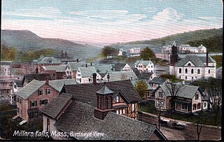
Millers Falls is a census-designated place (CDP) in the towns of Montague and Erving in Franklin County, Massachusetts, United States. The population was 1,139 at the 2010 census. It is part of the Springfield, Massachusetts metropolitan statistical area.

<span class="mw-page-title-main">Monson Center, Massachusetts</span> Census-designated place in Massachusetts, United States

Monson Center is a census-designated place (CDP) in the town of Monson in Hampden County, Massachusetts, United States. The population was 2,107 at the 2010 census, out of a total 8,560 people in the town. It is part of the Springfield, Massachusetts Metropolitan Statistical Area.

<span class="mw-page-title-main">Amherst Center, Massachusetts</span> Census-designated place in Massachusetts, United States

Amherst Center is a census-designated place (CDP) in the City of Amherst in Hampshire County, Massachusetts, United States. The CDP covers the primary village in town. The population was 19,065 at the 2010 census, out of a total town population of 37,819. It is part of the Springfield, Massachusetts Metropolitan Statistical Area.

<span class="mw-page-title-main">North Amherst, Massachusetts</span> Census-designated place in Massachusetts, United States

North Amherst is a census-designated place (CDP) in the city of Amherst in Hampshire County, Massachusetts, United States. The population was 6,819 at the 2010 census, up from 6,019 at the 2000 census. It is part of the Springfield, Massachusetts Metropolitan Statistical Area.

<span class="mw-page-title-main">South Amherst, Massachusetts</span> Census-designated place in Massachusetts, United States

South Amherst is a census-designated place (CDP) in the town of Amherst in Hampshire County, Massachusetts, United States. The population was 4,994 at the 2010 census. The CDP includes the village of South Amherst and residential subdivisions south of the Amherst town center.

<span class="mw-page-title-main">Cochituate, Massachusetts</span> Census-designated place in Massachusetts, United States

Cochituate is a census-designated place (CDP) in the town of Wayland in Middlesex County, Massachusetts, United States. The population was 6,927 at the 2020 census, out of 13,943 in the entire town of Wayland.

<span class="mw-page-title-main">West Concord, Massachusetts</span> Census-designated place in Massachusetts, United States

West Concord is an unincorporated village and census-designated place (CDP) in the town of Concord in Middlesex County, Massachusetts, United States. The population was 6,320 at the 2020 census.

<span class="mw-page-title-main">Fiskdale, Massachusetts</span> CDP in Sturbridge, Massachusetts, United States

Fiskdale is a census-designated place (CDP) in the town of Sturbridge in Worcester County, Massachusetts, United States. The population was 2,583 at the 2010 census.

<span class="mw-page-title-main">Great Barrington (CDP), Massachusetts</span> Census-designated place in Massachusetts, United States

Great Barrington is a census-designated place (CDP) located in the town of Great Barrington in Berkshire County, Massachusetts, United States. The population was 2,231 at the 2010 census, out of 7,104 in the entire town of Great Barrington.

<span class="mw-page-title-main">Belchertown (CDP), Massachusetts</span> Census-designated place in Massachusetts, United States

Belchertown is a census-designated place (CDP) comprising the central village in the town of Belchertown in Hampshire County, Massachusetts, United States. The population was 2,899 at the 2010 census, out of a total town population of 14,649. It is part of the Springfield, Massachusetts Metropolitan Statistical Area.

<span class="mw-page-title-main">Hatfield (CDP), Massachusetts</span> Census-designated place in Massachusetts, United States

Hatfield is a census-designated place (CDP) comprising the main village in the town of Hatfield in Hampshire County, Massachusetts, United States. The population of the CDP was 1,318 at the 2010 census, out of a total town population of 3,279. It is part of the Springfield, Massachusetts Metropolitan Statistical Area.

<span class="mw-page-title-main">Ware (CDP), Massachusetts</span> Census-designated place in Massachusetts, United States

Ware is a census-designated place (CDP) comprising the main village in the town of Ware in Hampshire County, Massachusetts, United States. The population of the CDP was 6,170 at the 2010 census, out of a total town population of 9,872. It is part of the Springfield, Massachusetts Metropolitan Statistical Area.

<span class="mw-page-title-main">Ayer (CDP), Massachusetts</span> Census-designated place in Massachusetts, United States

Ayer is a census-designated place (CDP) and the primary settlement in the town of Ayer in Middlesex County, Massachusetts, United States. The population of the CDP was 2,986 at the 2020 census, out of 8,479 in the entire town.

<span class="mw-page-title-main">Groton (CDP), Massachusetts</span> Census-designated place in Massachusetts, United States

Groton is a census-designated place (CDP) comprising the main village in the town of Groton in Middlesex County, Massachusetts, United States. The population of the CDP was 1,353 at the 2020 census, out of 11,315 in the entire town of Groton.

<span class="mw-page-title-main">Hudson (CDP), Massachusetts</span> Census-designated place in Massachusetts, United States

Hudson is a census-designated place (CDP) comprising the densely developed central part of the town of Hudson in Middlesex County, Massachusetts, United States. The population of the CDP was 15,749 at the 2020 census, out of 20,092 in the entire town.

<span class="mw-page-title-main">Pepperell (CDP), Massachusetts</span> Census-designated place in Massachusetts, United States

Pepperell is a census-designated place (CDP) comprising the main village in the town of Pepperell in Middlesex County, Massachusetts, United States. The population was 2,390 at the 2020 census, out of 11,604 in the entire town of Pepperell.

<span class="mw-page-title-main">Shirley (CDP), Massachusetts</span> Census-designated place in Massachusetts, United States

Shirley is a census-designated place (CDP) comprising the main village in the town of Shirley in Middlesex County, Massachusetts, United States. The population was 1,611 at the 2020 census, out of 7,431 in the entire town of Shirley.

<span class="mw-page-title-main">Townsend (CDP), Massachusetts</span> Census-designated place in Massachusetts, United States

Townsend is a census-designated place (CDP) comprising the main village in the town of Townsend in Middlesex County, Massachusetts, United States. The population was 1,213 at the 2020 census, out of 9,127 in the entire town.

References

  1. "2020 U.S. Gazetteer Files". United States Census Bureau. Retrieved May 21, 2022.
  2. 1 2 "Geographic Identifiers: 2010 Census Summary File 1 (G001): Granby CDP, Massachusetts". American Factfinder. U.S. Census Bureau. Archived from the original on February 13, 2020. Retrieved August 10, 2017.
  3. "US Gazetteer files: 2010, 2000, and 1990". United States Census Bureau. February 12, 2011. Retrieved April 23, 2011.
  4. "TIGERweb: Granby CDP, Massachusetts". Geography Division, U.S. Census Bureau. Retrieved August 10, 2017.
  5. "Census of Population and Housing". Census.gov. Retrieved June 4, 2016.
  6. "U.S. Census website". United States Census Bureau . Retrieved January 31, 2008.