Cummington, Massachusetts

Last updated

Cummington, Massachusetts
Fire Department, Cummington MA.jpg
Former Cummington Fire Department headquarters
Flag of Cummington, Massachusetts.png
Seal of Cummington, Massachusetts.png
Hampshire County Massachusetts incorporated and unincorporated areas Cummington highlighted.svg
Coordinates: 42°27′42″N72°53′40″W / 42.46167°N 72.89444°W / 42.46167; -72.89444
Country United States
State Massachusetts
County Hampshire
Settled1762
Incorporated1779
Government
  Type Open town meeting
Area
  Total23.1 sq mi (59.7 km2)
  Land22.9 sq mi (59.3 km2)
  Water0.1 sq mi (0.3 km2)
Elevation
[1]
1,519 ft (463 m)
Population
 (2020)
  Total829
  Density36/sq mi (14/km2)
Time zone UTC−5 (Eastern)
  Summer (DST) UTC−4 (Eastern)
ZIP Code
01026
Area code 413
FIPS code 25-16040
GNIS feature ID0618198 [1]
Website www.cummington-ma.gov

Cummington is a town in Hampshire County, Massachusetts, United States. The population was 829 at the 2020 census, [2] a decline from the figure of 872 tabulated in 2010. It is part of the Springfield, Massachusetts Metropolitan Statistical Area.

Contents

History

Cummington was first settled in 1762 and was officially incorporated in 1779. It was named after Colonel John Cumings, the original landholder. [3]

The first Congregational Church minister was Rev. James Briggs (1743–1825) of Norton, Massachusetts, and a graduate of Yale College around 1775. [4] Briggs was the son of Deacon James and Damaris (White) Briggs, and the husband of Anna Wiswall.

Although a small town, several Revolutionary War patriots are buried there, including Nathaniel Holbrook, Seth Wilder Sr., and Seth Wilder Jr.

Noted poet and newspaper editor William Cullen Bryant was born in Cummington, and returned for many years to summer in the town. His house is now preserved and open to the public as the William Cullen Bryant Homestead. The town hosts the Cummington Fair every August on the town's fairgrounds. The fair features many events, including adult and 4-H exhibition halls, a craft barn, vaudeville stage, antique car parade, oxen pull, and an assortment of fair rides, games, and food stands.

The town was the subject of a 1945 documentary film, The Cummington Story, about the welcome given to a group of European refugees. [5]

Geography

Cummington is in northwestern Hampshire County. It is bordered to the west by the towns of Peru and Windsor in Berkshire County, to the north by Plainfield in Hampshire County, and to the northeast by Ashfield in Franklin County. To the east is the town of Goshen, to the southeast is Chesterfield, and to the south is Worthington, all in Hampshire County.

According to the United States Census Bureau, the town has a total area of 23.1 square miles (59.7 km2), of which 22.9 square miles (59.3 km2) are land and 0.1 square miles (0.3 km2), or 0.56%, are water. [6] The Westfield River (sometimes referred to as the East Branch) flows through Cummington. Massachusetts Route 9 runs through the town, following the Westfield River for most of its way. Route 9 leads southeast 20 miles (32 km) to Northampton and west 22 miles (35 km) to Pittsfield. Massachusetts Route 112 leads west, then south, 21 miles (34 km) to Huntington.

The mineral cummingtonite was first found in this town and was named after it. [7] [8]

Demographics

As of the census [20] of 2000, there were 978 people, 382 households, and 239 families residing in the town. The population density was 42.4 inhabitants per square mile (16.4/km2). There were 452 housing units at an average density of 19.6 per square mile (7.6/km2). The racial makeup of the town was 96.42% White, 0.61% African American, 0.41% Native American, 0.31% Asian, 0.51% from other races, and 1.74% from two or more races. Hispanic or Latino of any race were 3.27% of the population.

There were 382 households, out of which 24.3% had children under the age of 18 living with them, 54.2% were married couples living together, 5.8% had a female householder with no husband present, and 37.4% were non-families. 28.0% of all households were made up of individuals, and 10.2% had someone living alone who was 65 years of age or older. The average household size was 2.26 and the average family size was 2.77.

In the town, the population was spread out, with 27.9% under the age of 18, 5.7% from 18 to 24, 30.3% from 25 to 44, 24.8% from 45 to 64, and 11.2% who were 65 years of age or older. The median age was 38 years. For every 100 females, there were 102.5 males. For every 100 females age 18 and over, there were 92.1 males.

The median income for a household in the town was $42,250, and the median income for a family was $48,750. Males had a median income of $31,765 versus $27,279 for females. The per capita income for the town was $21,553. About 4.2% of families and 6.6% of the population were below the poverty line, including 5.7% of those under age 18 and none of those age 65 or over.

Education

Cummington is part of the Central Berkshire Regional School District, along with Becket, Dalton, Hinsdale, Peru, Washington, and Windsor. Elementary school students attend Craneville School, middle school students attend Nessacus Regional Middle School, and high school students attend Wahconah Regional High School.

Government

The town is part of the First Hampshire District in the Massachusetts House of Representatives, and the Berkshire, Hampden, Franklin, and Hampshire Senate district.

Points of interest

Notable people

Related Research Articles

<span class="mw-page-title-main">Egremont, Massachusetts</span> Town in Massachusetts, United States

Egremont is a town in Berkshire County, Massachusetts, United States. It is part of the Pittsfield, Massachusetts Metropolitan Statistical Area. The population was 1,372 at the 2020 census. Egremont consists of two villages, North Egremont and South Egremont, and their outlying areas, which are mostly lightly settled forests and farmland.

<span class="mw-page-title-main">Hancock, Massachusetts</span> Town in Massachusetts, United States

Hancock is a town in Berkshire County, Massachusetts, United States. It is part of the Pittsfield, Massachusetts Metropolitan Statistical Area. The population was 757 at the 2020 census.

<span class="mw-page-title-main">Peru, Massachusetts</span> Town in Massachusetts, United States

Peru is a town in Berkshire County, Massachusetts, United States. The population was 814 at the 2020 census.

<span class="mw-page-title-main">Savoy, Massachusetts</span> Town in Massachusetts, United States

Savoy is a town in Berkshire County, Massachusetts, United States. It is part of the Pittsfield, Massachusetts Metropolitan Statistical Area. The population was 645 at the 2020 census.

<span class="mw-page-title-main">Windsor, Massachusetts</span> Town in Massachusetts, United States

Windsor is a town in Berkshire County, Massachusetts, United States. It is part of the Metropolitan Statistical Area of Pittsfield, Massachusetts. The population was 831 at the 2020 census.

<span class="mw-page-title-main">Ashfield, Massachusetts</span> Town in Massachusetts, United States

Ashfield is a town in Franklin County, Massachusetts, United States. The population was 1,695 at the 2020 census. It is part of the Springfield, Massachusetts Metropolitan Statistical Area.

<span class="mw-page-title-main">Colrain, Massachusetts</span> Town in Massachusetts, United States

Colrain is a town in Franklin County, Massachusetts, United States. The population was 1,606 at the 2020 census. It is part of the Springfield, Massachusetts Metropolitan Statistical Area.

<span class="mw-page-title-main">Conway, Massachusetts</span> Town in Massachusetts, United States

Conway is a town in Franklin County, Massachusetts, United States. The population was 1,761 at the 2020 census. It is part of the Springfield, Massachusetts Metropolitan Statistical Area.

<span class="mw-page-title-main">Monroe, Massachusetts</span> Town in Massachusetts, United States

Monroe is a town in Franklin County, Massachusetts, United States. The population was 118 at the 2020 census. By area, population, and population density, it is the smallest town in the county; and is the second-smallest town by population in the Commonwealth, with only Gosnold having fewer residents.

<span class="mw-page-title-main">New Salem, Massachusetts</span> Town in Massachusetts, United States

New Salem is a town in Franklin County, Massachusetts, United States. The population was 983 at the 2020 census. It is part of the Springfield, Massachusetts Metropolitan Statistical Area.

<span class="mw-page-title-main">Whately, Massachusetts</span> Town in Massachusetts, United States

Whately is a town in Franklin County, Massachusetts, United States. The population was 1,607 at the 2020 census. It is part of the Springfield, Massachusetts Metropolitan Statistical Area.

<span class="mw-page-title-main">Huntington, Massachusetts</span> Town in Massachusetts, United States

Huntington is a town in Hampshire County, Massachusetts, United States. The population was 2,094 at the 2020 census. It is part of the Springfield, Massachusetts Metropolitan Statistical Area.

<span class="mw-page-title-main">Plainfield, Massachusetts</span> Town in Massachusetts, United States

Plainfield is a town on the northwestern edge of Hampshire County, Massachusetts, United States, about 25 miles east of Pittsfield and 30 miles northwest of Northampton. The population was 633 at the 2020 census. It is part of the Springfield, Massachusetts Metropolitan Statistical Area.

<span class="mw-page-title-main">Westhampton, Massachusetts</span> Town in Massachusetts, United States

Westhampton is a town in Hampshire County, Massachusetts, United States. The population was 1,622 at the 2020 census. It is part of the Springfield, Massachusetts Metropolitan Statistical Area.

<span class="mw-page-title-main">Williamsburg, Massachusetts</span> Town in Massachusetts, United States

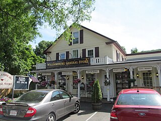
Williamsburg is a town in Hampshire County, Massachusetts, United States. The population was 2,504 at the 2020 census. It is part of the Springfield, Massachusetts Metropolitan Statistical Area.

<span class="mw-page-title-main">Worthington, Massachusetts</span> Town in Massachusetts, United States

Worthington is a town in Hampshire County, Massachusetts, United States. The population was 1,193 at the 2020 census, up from 1,156 at the 2010 census. It is part of the Springfield, Massachusetts Metropolitan Statistical Area.

<span class="mw-page-title-main">Ashburnham, Massachusetts</span> Town in Massachusetts, United States

Ashburnham is a town in Worcester County, Massachusetts, United States. At the 2020 census, the town population was 6,315. It is home to Cushing Academy, a private preparatory boarding school.

<span class="mw-page-title-main">Phillipston, Massachusetts</span> Town in Massachusetts, United States

Phillipston is a town in Worcester County, Massachusetts, United States. The population was 1,724 at the 2020 census.

<span class="mw-page-title-main">Townsend, Massachusetts</span> Town in Massachusetts, United States

Townsend is a town in Middlesex County, Massachusetts, United States. The population was 9,127 at the 2020 census.

<span class="mw-page-title-main">North Brookfield, Massachusetts</span> Town in Massachusetts, United States

North Brookfield is a town in Worcester County, Massachusetts, United States. The population was 4,735 at the 2020 census.

References

  1. 1 2 U.S. Geological Survey Geographic Names Information System: Cummington, Massachusetts
  2. "Census - Geography Profile: Cummington town, Hampshire County, Massachusetts". United States Census Bureau . Retrieved November 14, 2021.
  3. Town of Cummington - History
  4. William W. Streeter and Daphne H. Morris, Editors, The Vital Records of Cummington, Massachusetts 1762-1900 (Hartford, CT: William W. Streeter and D. H. Morris, 1979)
  5. Arthur Knight. The Liveliest Art: A Panoramic History of the Movies, New York: Mentor, n.d. p. 254.
  6. "Geographic Identifiers: 2010 Census Summary File 1 (G001): Cummington town, Hampshire County, Massachusetts". American Factfinder. U.S. Census Bureau. Archived from the original on February 13, 2020. Retrieved August 8, 2017.
  7. http://rruff.geo.arizona.edu/doclib/hom/cummingtonite.pdf Handbook of Mineralogy, 2001, Mineral Data Pub.
  8. http://www.mindat.org/min-1170.html Mindat data
  9. "Total Population (P1), 2010 Census Summary File 1". American FactFinder, All County Subdivisions within Massachusetts. United States Census Bureau. 2010.
  10. "Massachusetts by Place and County Subdivision - GCT-T1. Population Estimates". United States Census Bureau. Retrieved July 12, 2011.
  11. "1990 Census of Population, General Population Characteristics: Massachusetts" (PDF). US Census Bureau. December 1990. Table 76: General Characteristics of Persons, Households, and Families: 1990. 1990 CP-1-23. Retrieved July 12, 2011.
  12. "1980 Census of the Population, Number of Inhabitants: Massachusetts" (PDF). US Census Bureau. December 1981. Table 4. Populations of County Subdivisions: 1960 to 1980. PC80-1-A23. Retrieved July 12, 2011.
  13. "1950 Census of Population" (PDF). Bureau of the Census. 1952. Section 6, Pages 21-10 and 21-11, Massachusetts Table 6. Population of Counties by Minor Civil Divisions: 1930 to 1950. Retrieved July 12, 2011.
  14. "1920 Census of Population" (PDF). Bureau of the Census. Number of Inhabitants, by Counties and Minor Civil Divisions. Pages 21-5 through 21-7. Massachusetts Table 2. Population of Counties by Minor Civil Divisions: 1920, 1910, and 1920. Retrieved July 12, 2011.
  15. "1890 Census of the Population" (PDF). Department of the Interior, Census Office. Pages 179 through 182. Massachusetts Table 5. Population of States and Territories by Minor Civil Divisions: 1880 and 1890. Retrieved July 12, 2011.
  16. "1870 Census of the Population" (PDF). Department of the Interior, Census Office. 1872. Pages 217 through 220. Table IX. Population of Minor Civil Divisions, &c. Massachusetts. Retrieved July 12, 2011.
  17. "1860 Census" (PDF). Department of the Interior, Census Office. 1864. Pages 220 through 226. State of Massachusetts Table No. 3. Populations of Cities, Towns, &c. Retrieved July 12, 2011.
  18. "1850 Census" (PDF). Department of the Interior, Census Office. 1854. Pages 338 through 393. Populations of Cities, Towns, &c. Retrieved July 12, 2011.
  19. "City and Town Population Totals: 2020−2022". United States Census Bureau . Retrieved November 24, 2023.
  20. "U.S. Census website". United States Census Bureau . Retrieved January 31, 2008.