
Salisbury Plain is a chalk plateau in the south western part of central southern England covering 300 square miles (780 km2). It is part of a system of chalk downlands throughout eastern and southern England formed by the rocks of the Chalk Group and largely lies within the county of Wiltshire, but stretches into Hampshire.

Lardon Chase, the Holies and Lough Down is a National Trust countryside property in the English county of Berkshire. It is situated on the edge of the Berkshire Downs above the village of Streatley and overlooking the Goring Gap. The property omprises an outstanding area of 27 hectares of downland and woodland with many attractive walks and views. Lardon Chase, and a part of the Holies known as Holies Down, are also designated as Sites of Special Scientific Interest. The property lies within the North Wessex Downs Area of Outstanding Natural Beauty, and in an area known for the presence of several Neolithic and Iron Age forts.

Beacon Hill is near the village of Burghclere and Watership Down, in north Hampshire. The hill's name is derived from the fact that it was one of many Beacon Hills in England and beyond. This hill was once the site of the most famous beacon in Hampshire. It is 261 metres high and has one of England's most well known hill forts on its slopes, visible from the main A34 road which passes close by. From there, outstanding views of the surrounding area and much of Hampshire may be obtained. The site is open to the public and managed by Hampshire County Council. It is an 80.7-hectare (199-acre) biological Site of Special Scientific Interest called Burghclere Beacon and a Nature Conservation Review site, Grade I.

Windsor Hill is a 61.8 hectare biological Site of Special Scientific Interest in Princes Risborough in Buckinghamshire. It lies within the Chilterns Area of Outstanding Natural Beauty, and it is featured in the Nature Conservation Review. A small part is managed by the Berkshire, Buckinghamshire and Oxfordshire Wildlife Trust, and access to this area requires a permit.

Noar Hill is a 63-hectare (160-acre) biological Site of Special Scientific Interest south of Selborne in Hampshire. It is a Nature Conservation Review site, Grade 2, and part of East Hampshire Hangers Special Area of Conservation. An area of 20 hectares is a nature reserve managed by the Hampshire and Isle of Wight Wildlife Trust.
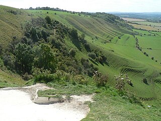
Bratton Downs is a 395.8 hectare biological and geological Site of Special Scientific Interest in Wiltshire, England, near the villages of Bratton and Edington, and about 3 miles (5 km) east of the town of Westbury. It was notified in 1971. The designated area consists mainly of chalk grassland, as well as some ancient woodland, and supports a diverse range of native flora and fauna. It overlays notable geological features—principally landforms created by glaciation in the Pleistocene.

Morgan's Hill is a 12.6-hectare (31-acre) biological Site of Special Scientific Interest between Calne and Devizes in Wiltshire, England. The SSSI was notified in 1951 and again in 1987.

Long Knoll is a hill in the west of the English county of Wiltshire. It is a ridge of chalk grassland, some 1.5 kilometres (1 mi) in length, and forms the boundary between the civil parishes of Kilmington to the south and Maiden Bradley to the north. The ridge is 288 metres (945 ft) above sea level at its highest point and it is possible to view King Alfred's Tower, Cranmore Tower, the Black Mountains and Glastonbury Tor on clear days.

Pewsey Downs is a 305.3 hectare biological Site of Special Scientific Interest on the southern edge of the Marlborough Downs north of Pewsey in Wiltshire, notified in 1951. It includes the Pewsey Downs National Nature Reserve.
NVC community CG2 is one of the calcicolous grassland communities in the British National Vegetation Classification system. It is one of three short-sward communities associated with heavy grazing, within the lowland calcicolous grassland group, and is regarded as "typical" chalk grassland.

Barnsley Warren is a 61.3-hectare (151-acre) biological Site of Special Scientific Interest in Gloucestershire, notified in 1954 and renotified in 1984. The site is also included in A Nature Conservation Review. It lies in a steep-sided dry valley, east of the A429, northeast of Cirencester in the Cotswolds. The site is listed in the 'Cotswold District' Local Plan 2001-2011 as a Key Wildlife Site (KWS).

Park Gate Down or Parkgate Down is a 7-hectare (17-acre) biological Site of Special Scientific Interest south-east of Stelling Minnis in Kent. It is also a Special Area of Conservation and is managed by the Kent Wildlife Trust,

Totternhoe Knolls is a 13.1 hectare Site of Special Scientific Interest (SSSI) in Totternhoe in Bedfordshire. It is also a local nature reserve, and part of the Chilterns Area of Outstanding Natural Beauty. The site is owned by Central Bedfordshire Council and leased to the National Trust. Most of the site is maintained jointly by the National Trust and the Wildlife Trust for Bedfordshire, Cambridgeshire and Northamptonshire (WTBCN), and is part of the WTBCN Totternhoe nature reserve, which also includes Totternhoe Chalk Quarry and Totternhoe Stone Pit. The SSSI also includes Totternhoe Castle, the earthworks of a Norman motte-and-bailey castle which is a Scheduled monument.
NVC community CG5 is one of the calcicolous grassland communities in the British National Vegetation Classification system. It is one of four communities of rank, tussocky grassland associated with low levels of grazing, within the lowland calcicolous grassland group.
NVC community CG1 is one of the calcicolous grassland communities in the British National Vegetation Classification system. It is one of three short-sward communities associated with heavy grazing, within the lowland calcicolous grassland group, and is regarded as the south-west coastal counterpart of "typical" chalk grassland.
Chalk heath is a rare habitat, in the temperate grasslands, savannas, and shrublands biome, formed of a paradoxical mixture of shallow-rooted calcifuge ("calcium-hating") and deeper-rooted calcicole ("calcium-loving") plants, growing on a thin layer of acidic soil over an alkaline substrate. Chalk heath is intermediate between two much more widespread habitats, chalk grassland and heathland.
Deacon Hill SSSI is a 35.4 hectare biological Site of Special Scientific Interest in Pegsdon in Bedfordshire. It is in the Chilterns Area of Outstanding Natural Beauty, and it is part of the Pegsdon Hills and Hoo Bit nature reserve, managed by Wildlife Trust for Bedfordshire, Cambridgeshire and Northamptonshire.

Ladle Hill is a 10.5-hectare (26-acre) biological Site of Special Scientific Interest west of Kingsclere in Hampshire. It is also a Scheduled Monument.
Gentianella anglica, the early gentian, is a species of flowering plant in the genus Gentianella, native to Great Britain. Gentianella anglica is endemic to Great Britain and its centre of distribution is in Dorset, Wiltshire, and the Isle of Wight.

Cleeve Hill is a 4-hectare (9.9-acre) biological Site of Special Scientific Interest south of Lambourn in Berkshire.

