
Bucks County is a county located in the Commonwealth of Pennsylvania. As of the 2010 census, the population was 625,249, making it the fourth-most populous county in Pennsylvania and the 99th-most populous county in the United States. The county seat is Doylestown. The county is named after the English county of Buckinghamshire or more precisely, its shortname.

Buck Township is a township in Luzerne County, Pennsylvania, United States. As of the 2010 census, the population was 435, making it the least populous township in the county.
Street, Maryland is a rural unincorporated community in northern Harford County, Maryland. Street was first settled by Dutch immigrants in the early 18th century.

Eddington is a census-designated place located in Bucks County, Pennsylvania. The community was part of Cornwells Heights-Eddington, which was split into two separate CDPs. As of the 2010 census, the population was 1,906. The community is served by the Eddington station along SEPTA Regional Rail's Trenton Line.

Summerseat, also known as the George Clymer House and Thomas Barclay House, is a historic house museum at Hillcrest and Legion Avenues in Morrisville, Bucks County, Pennsylvania. Built about 1770, it is the only house known to be owned by two signers of the United States Declaration of Independence, George Clymer and Robert Morris, and as a headquarters of General George Washington during the American Revolutionary War. The house is now managed by the Morrisville Historical Society, which offers tours. It was designated a National Historic Landmark in 1965.
Milford Square is a census-designated place in Milford Township, Bucks County, Pennsylvania. It is located along PA Route 663 near the borough of Trumbauersville. As of the 2010 census, the population was 897 residents. While the village has a PO Box post office with the zip code of 18935, the surrounding area uses the Quakertown zip code of 18951. It is located on the Unami Creek which drains into the Perkiomen Creek. It was formerly known as Heistville after the Heist family who operated Achey's Mill and lived in, and greatly renovated, the miller’s home.

Almont is a populated place in Rockhill Township, Bucks County, Pennsylvania, United States, a half mile or so west of Sellersville.
Hagersville is a populated place situated in East Rockhill Township in Bucks County, Pennsylvania. It has an estimated elevation of 427 feet (130 m) above sea level.
Hartsville is a populated place situated at the crossroads of Bristol Road and the Old York Road straddling Warminster and Warwick Township in Bucks County, Pennsylvania. It has an estimated elevation of 427 feet (130 m) above sea level. It is served by the Warminster Post Office ZIP code 18974.

Highton is a populated place situated along the border of Buckingham and Solebury townships in Bucks County, Pennsylvania. The small settlement is located along Street Road at its intersection with Ridge Road. As the latter road's name implies, it is located along a ridge between Pidcock Creek and Curls Run about three and a half miles (5.6 km) southeast of New Hope. There are a few houses located around the settlement, the remainder consists of farms and properties containing large houses over rolling terrain.
Hilltop is a populated place situated in Springfield Township in Bucks County, Pennsylvania. It has an estimated elevation of 591 feet (180 m) above sea level.
Hinkletown is a populated place situated in Plumstead Township in Bucks County, Pennsylvania. It has an estimated elevation of 528 feet (161 m) above sea level.
Holicong is a populated place situated in Buckingham Township in Bucks County, Pennsylvania. It has an estimated elevation of 236 feet (72 m) above sea level.
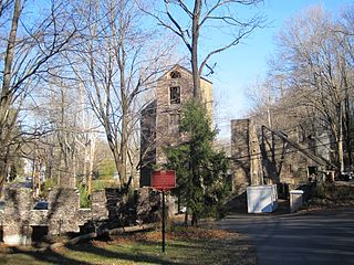
Hood is a populated place situated in New Hope, a borough in Bucks County, Pennsylvania. It has an estimated elevation of 108 feet (33 m) above sea level and is located at the intersection of Mechanic Street and Sugan Road. Nearby the settlement are the Aquetong Creek and New Hope and Ivyland Railroad. The site features ruins of the Robert Heath Mills, a grist mill built in the early 1700s. The original name of this community was Springdale.
Loux Corner is a populated place of 5 or 6 houses in Hilltown Township, Bucks County, Pennsylvania, United States. Formerly, it was known as Albrights Corner.

Highland Park is a populated place situated in Cochise County, Arizona. It has an estimated elevation of 5,800 feet (1,800 m) above sea level.
Highland Park, also known as Highland Pines, is a populated place situated in Yavapai County, Arizona. It has an estimated elevation of 6,411 feet (1,954 m) above sea level.
Applebachsville is populated place in Haycock Township, Bucks County, Pennsylvania 2.6 miles (4.2 km) northeast of Richlandtown.
Aquetong is populated place in Solebury Township, Bucks County, Pennsylvania along U.S. Route 202 about 2.9 miles (4.7 km) west of New Hope.
Brick Tavern is a populated place in Milford Township, Bucks County, Pennsylvania in the United States.


